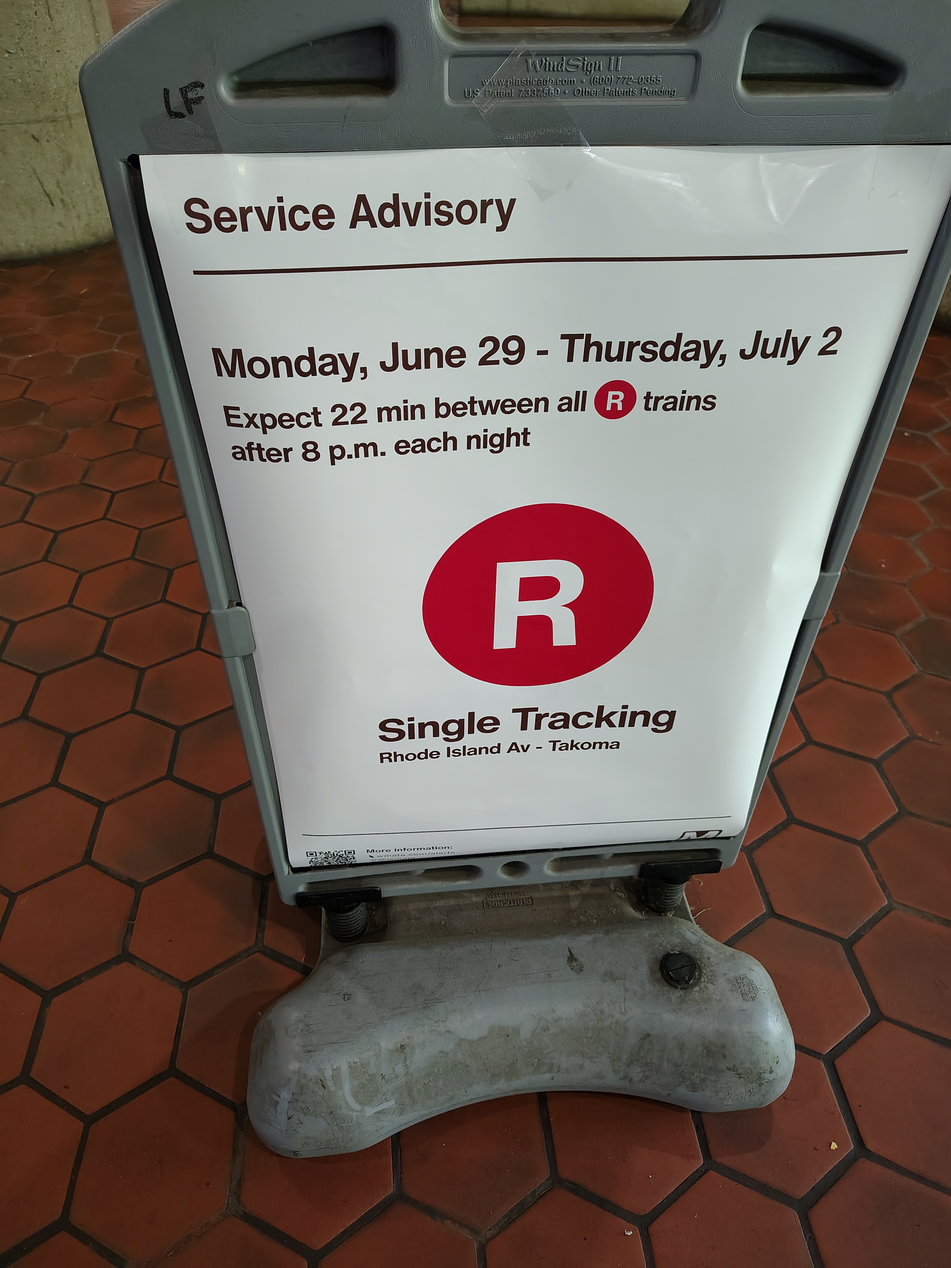
From June 29 to July 2, there will be single tracking on the red line between Rhode Island Ave & Takoma stations after 8pm. Plan accordingly.

From June 29 to July 2, there will be single tracking on the red line between Rhode Island Ave & Takoma stations after 8pm. Plan accordingly.
Information passed along by ANC Commissioner Garrett Moore (4B08) from DDOT:
Now that construction of the protected bike lanes is complete, ANC 4B will be hosting a project walkthrough on Monday, June 29, from 6 to 8 p.m. DDOT staff will be in attendance and welcome your participation. We’ll gather at the corner of Kansas Avenue and Madison Street for a brief discussion before walking the corridor together. This walkthrough is a great opportunity to share your feedback on the project and offer suggestions for improvement.
ANC 4B Kansas Ave Protected Bike Lane Project Post Construction Walkthrough
Monday, June 29, 2026
6pm to 8pm
Meet at Kansas Ave NW & Madison St NW
From Ward 5 Councilmember Zachary Parker’s newsletter
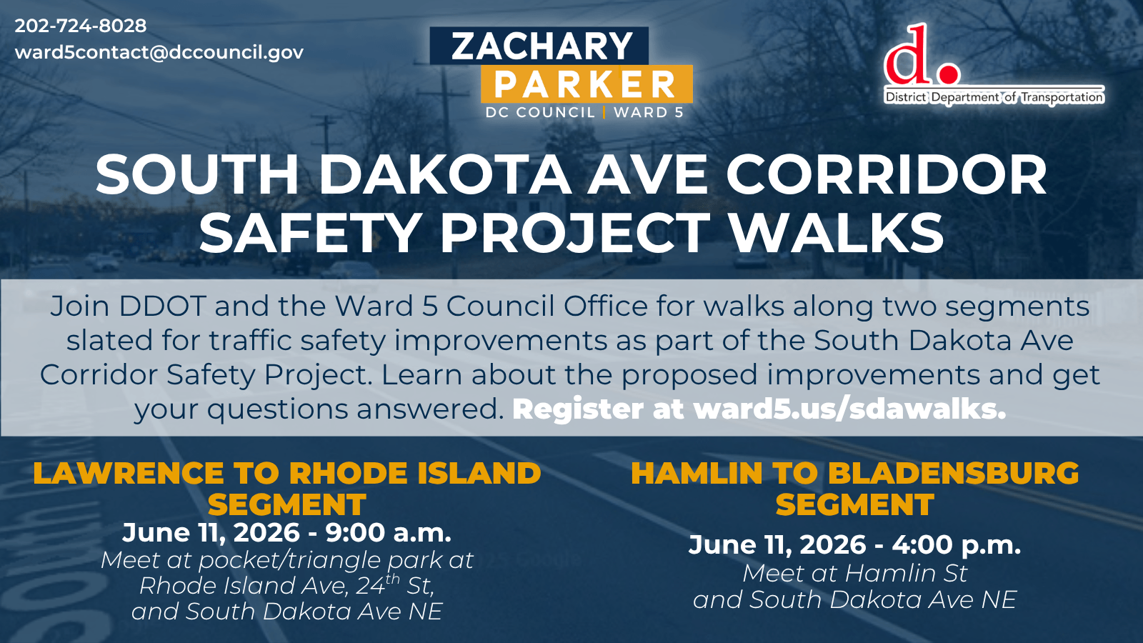
Following the South Dakota Ave Corridor Safety Study conducted by the District Department of Transportation (DDOT), targeted safety improvements are moving forward on two segments along the corridor using existing project funds:
DDOT invites neighbors to join DDOT staff and members of my office for community walks along these two segments to learn more about the proposed intersection safety treatments and ask questions. Please consider joining for one or both of these walks!
Please register to attend here. For more information on the project details please visit the project website.
Councilmember Parker is currently working to secure additional funds in the FY 27 budget to move forward with safety improvements at other segments along the South Dakota Avenue corridor.
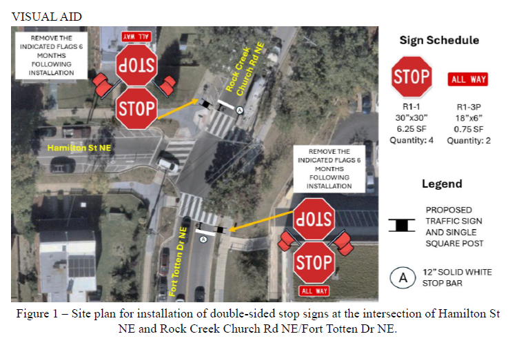
ANC Commissioner Valeria Sosa Garnica (5A07) passed along a Notice of Intent (NOI) from DDOT for proposed installation of all-way stop signs at the intersection of Fort Totten Drive/Rock Creek Church Road & Hamilton Street NE.
See NOI 26-158-PSD
From the NOI:
DETAIL PROPOSED ACTIONS
Citing risks to pedestrian safety at Hamilton St NE & Rock Creek Church Rd NE/Fort Totten Dr NE, DDOT listed an all-way stop control (AWSC) study as a medium-term recommendation for the 2024-2025 Bridges/Briya/Bilingual Safe Routes to School action plan. DDOT has since analyzed the intersection and determined that it fits the criteria for an all-way stop. DDOT will install double-sided stop signs and stop bar pavement markings at the northbound and southbound approaches on Fort Totten Dr NE and Rock Creek Church Rd NE. Following good practices to increase awareness of the new stop signs, DDOT will affix small flags to the new signs for the first 6 months after installation.
To view and submit comments on NOI 26-158-PSD, visit DDOT’s NOI portal at http://noi.ddot.dc.gov by June 29, 2026.
From ANC 5A
ANC 5A/5B Joint Committee on Taylor St Bike Lanes
This meeting is planned as an Open Meeting, but not a Public Meeting, so no agenda or voting is scheduled. The meeting will be recorded and a URL to the recording will be provided within 7 days of the meeting date.
Topic: Joint Special Committee on Taylor
Time: May 17, 2026 04:00 PM Eastern Time (US and Canada)
Join Zoom Meeting
https://dc-gov.zoom.us/j/89121638949?pwd=FZ0ZPpddgPiEy0oRgOHaFKWOaJVJy5.1
Meeting ID: 891 2163 8949
Passcode: 486647
One tap mobile
+13126266799,,89121638949#,,,,*486647# US (Chicago)
+16469313860,,89121638949#,,,,*486647# US
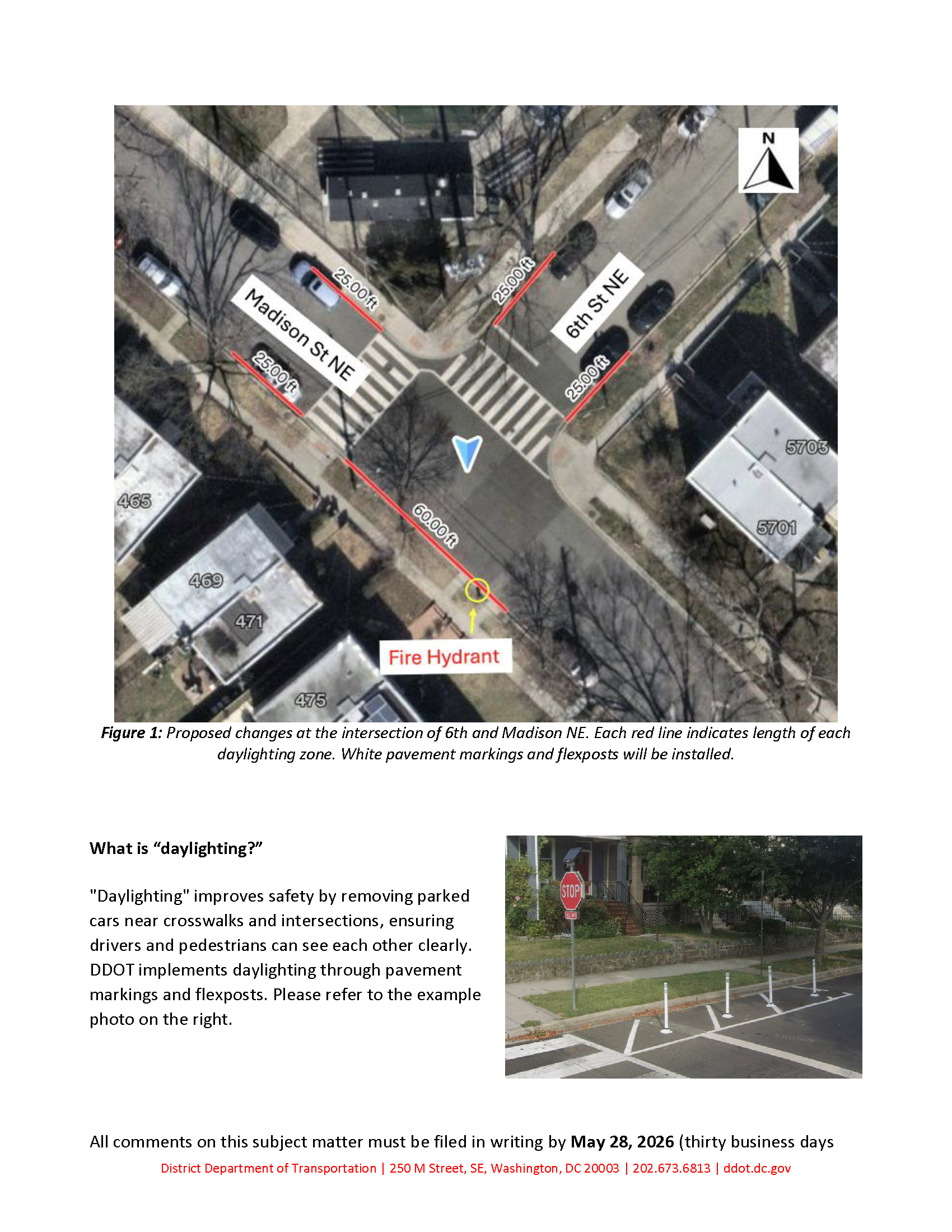
ANC Commissioner Danielle Geong (4B09) passed along information about a Notice of Intent (NOI) with proposed parking changes around 6th Street & Madison Street NE. DDOT is proposing to daylight the intersection of 6th and Madison by installing pavement markings and flexposts within 25 feet of the existing crosswalk.
See NOI 26-129-TSA.
Commissioner Geong wrote:
DDOT issued a plan to update 4B09 residential parking signage and daylight the intersection at 6th/Madison St NE to improve safety (please reference attachment for details). This is the southwest corner by Riggs field, where a lot of W4-5 neighbors walk to LaSalle ES, the rec center etc. Parking in and around the intersection will be prohibited in accordance with existing city regulations if the NOI moves forward.
Background: ANC 4B sent DDOT a traffic-calming resolution last year in response to a history of serious traffic accidents in the LaSalle-Backus ES school zone. LaSalle ES serves PK3-5 students in both ANCs 4B and 5A (5A01, 5A02, 5A07, 5A09).
To view and submit comments on this notice of intent (NOI 26-129-TSA Daylighting and Parking Change), visit DDOT’s NOI portal at http://noi.ddot.dc.gov by May 28, 2026.
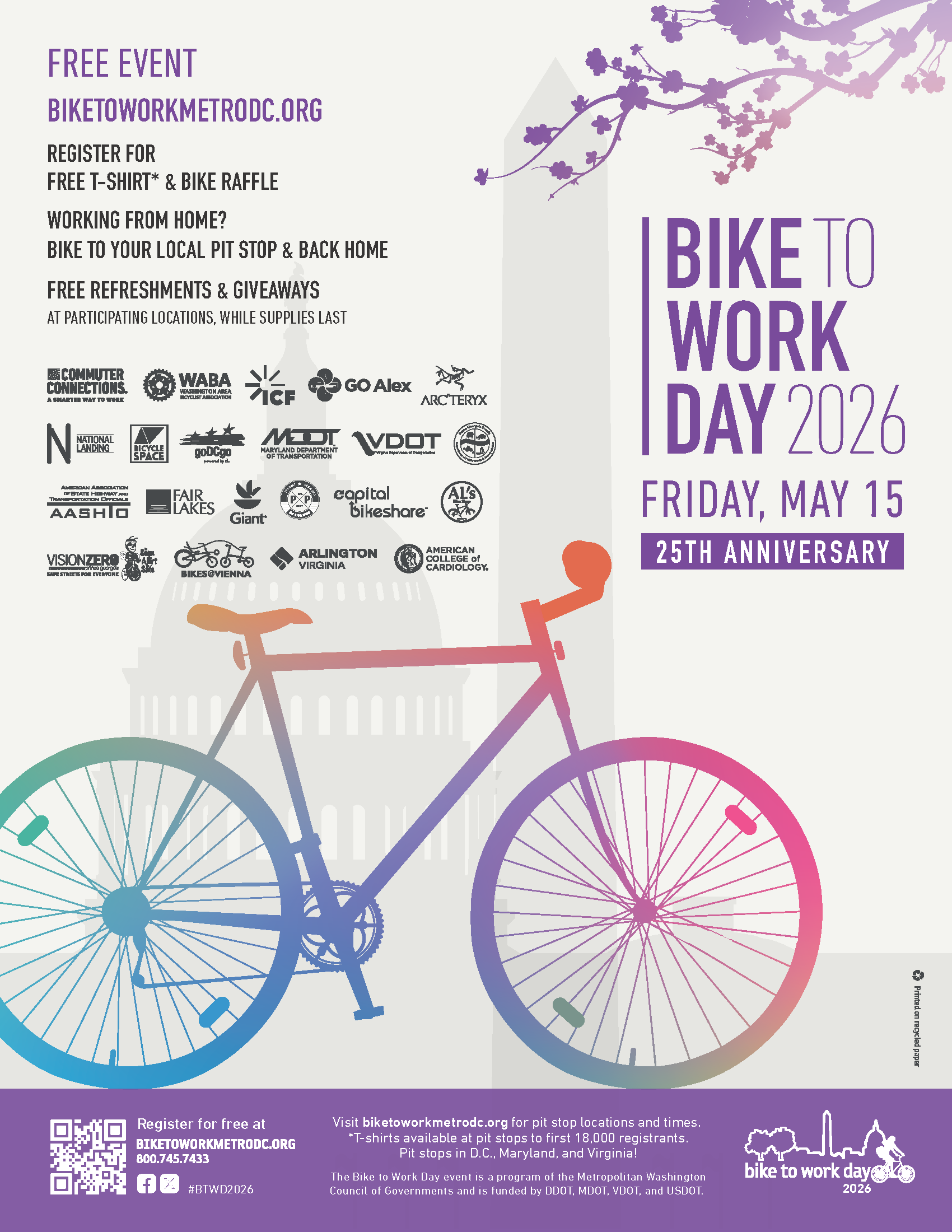
Tomorrow is Bike to Work Day. Fort Totten station is a pit stop location from 7am-9:30am. Find other pit stop locations at https://www.biketoworkmetrodc.org/pit-stop-locations.
DDOT recently installed a new Capital Bikeshare station at South Dakota Avenue & Ingraham Street NE. DDOT announced back in 2021 that they would put a bikeshare station at South Dakota & Galloway but circumstances led DDOT to put the station at Ingraham instead. Glad to have another bikeshare station in the neighborhood. Happy riding.
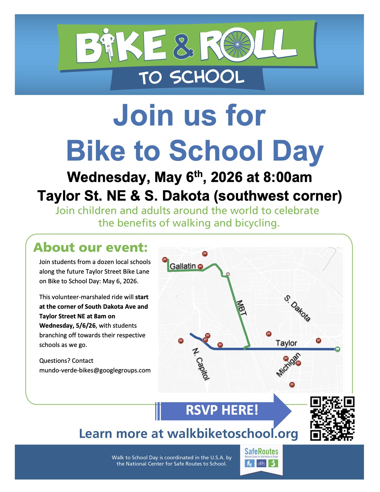
Tomorrow is Bike to School Day. Lots of children will be riding their bikes/scooters to school around the ward so drivers should be extra careful.
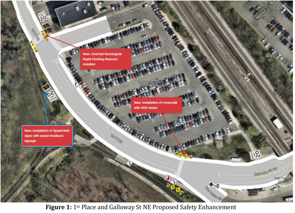
DDOT has proposed safety improvements along 1st Place & Galloway Street NE near Fort Totten Metro station: NOI-26-135-MSED.
Submit comments via DDOT’s NOI portal by June 8, 2026.
The NOI states:
In response to 7 crashes in the 2022-2024 period with 2 of the crashes involving pedestrians/bicyclists, DDOT is proposing safety treatments at 1st Pl NE and Galloway St NE listed below and depicted in Figure 1.
I support a lot of these proposals.
I think the speed limit should be 15 mph on 1st Place instead of 20 mph though. It is 15 mph on Galloway by the small parking lot. Cars and buses tend to fly around the bend along 1st Place. With the addition of a new crosswalk and the existing crosswalk closer to Riggs, to me it would make sense to maintain the lower speed limit.
A neighbor suggested and I agree that the right southbound lane leading to the restricted bus bays should be a marked “Bus Only” lane. People have taken to stopping in that lane, sometimes for long periods of time.
I like the idea of the new crosswalk on Galloway just south of the large parking lot. I just wonder if it is in the right place. I know sometimes the buses bunch together or stop along 1st Place just before the restricted bays. I suppose drivers would know not to stop in the crosswalk and if they do need to stop, then they need to provide enough distance for daylighting. Also, I think there should be a sign indicating that bikes may be crossing too, not just pedestrians.
It is still feels a bit chaotic for bike riders around the station. A multi-use path is supposed to be constructed on the south side of Galloway between South Dakota & 4th Street. National Park Service stated in February of this year that they had final plans for the design but that “a last-minute issue, raised by DC Water, regarding potential soft soils under the project may require a re-examination of the final plans.” So far, I have not heard any more updates. Until that path gets constructed, I wonder if it would be worthwhile to add sharrow markings to the road on Galloway. I know sharrows do not really do anything but maybe a reminder that bikes can use the road will help make things feel a little less chaotic around the station.
Submit your comments on NOI-26-235 on the NOI portal by June 8.
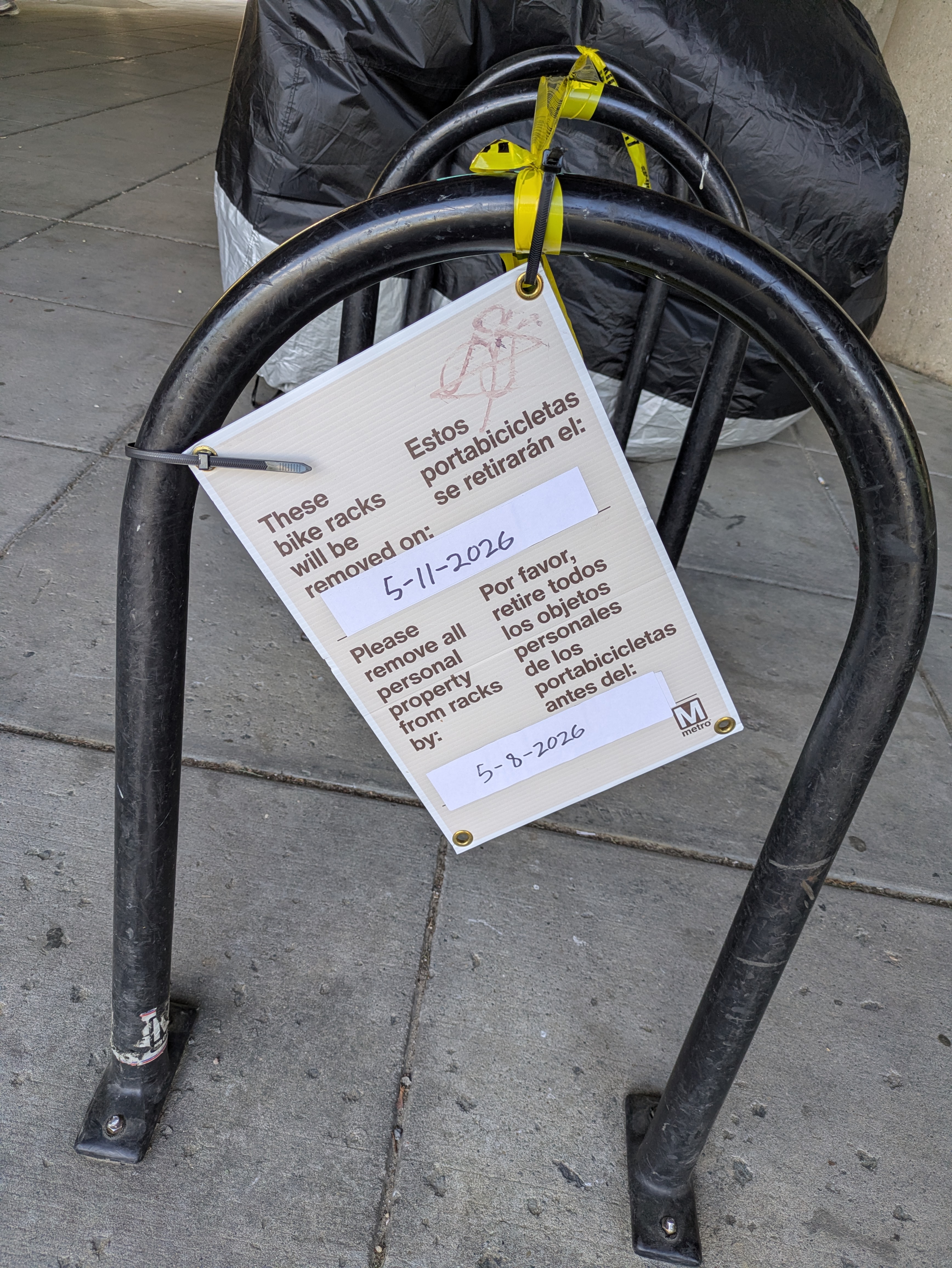
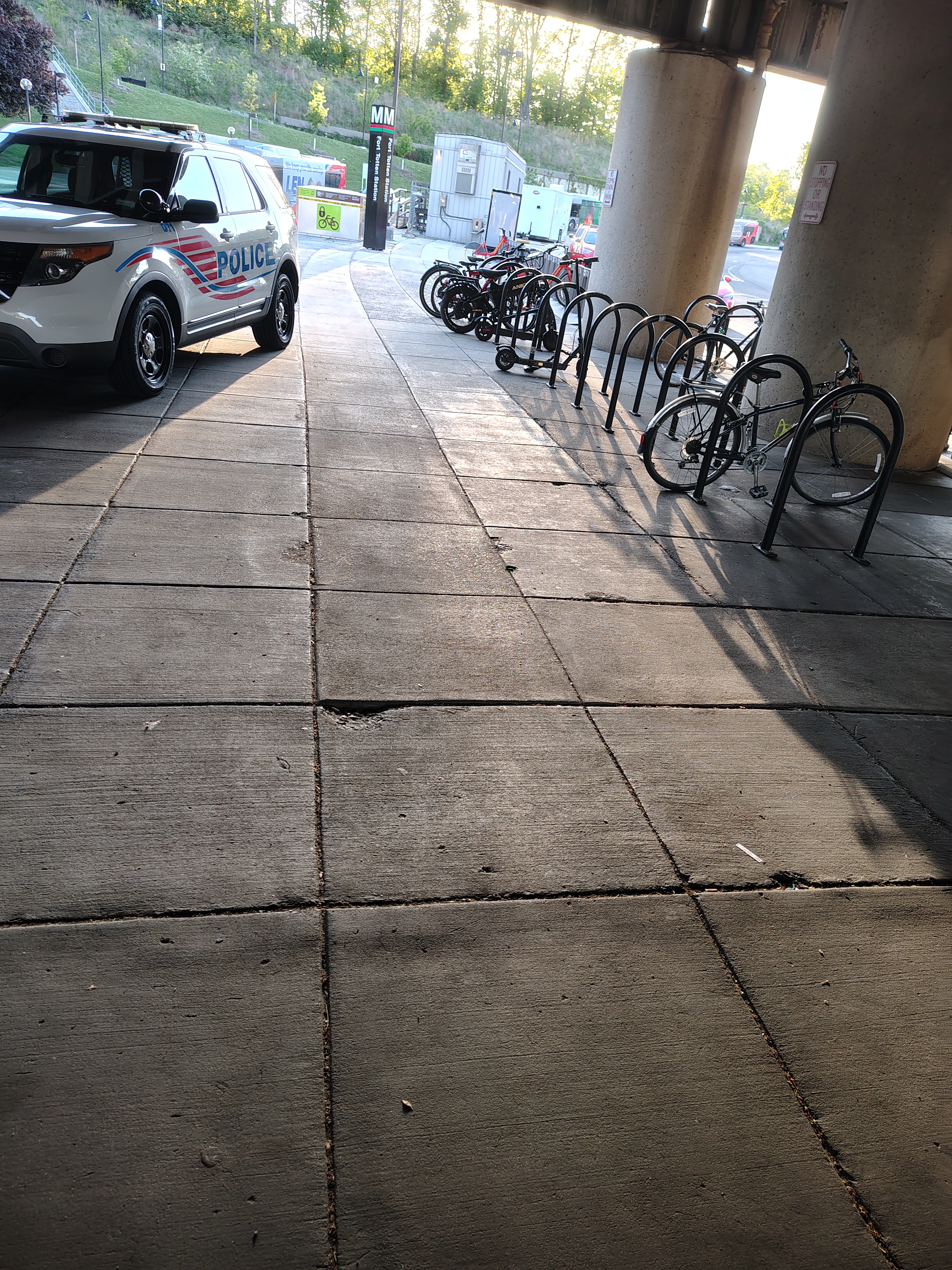
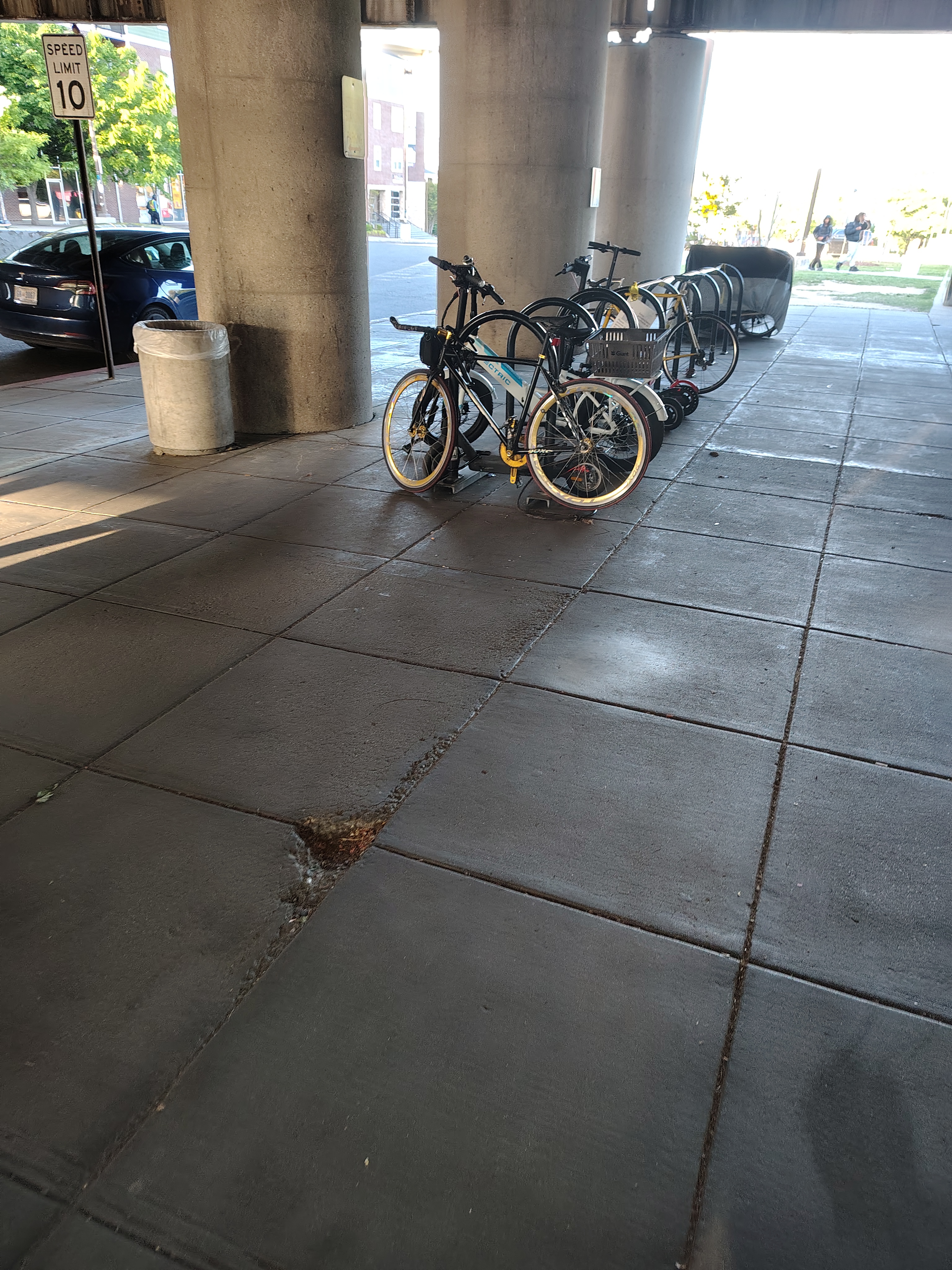
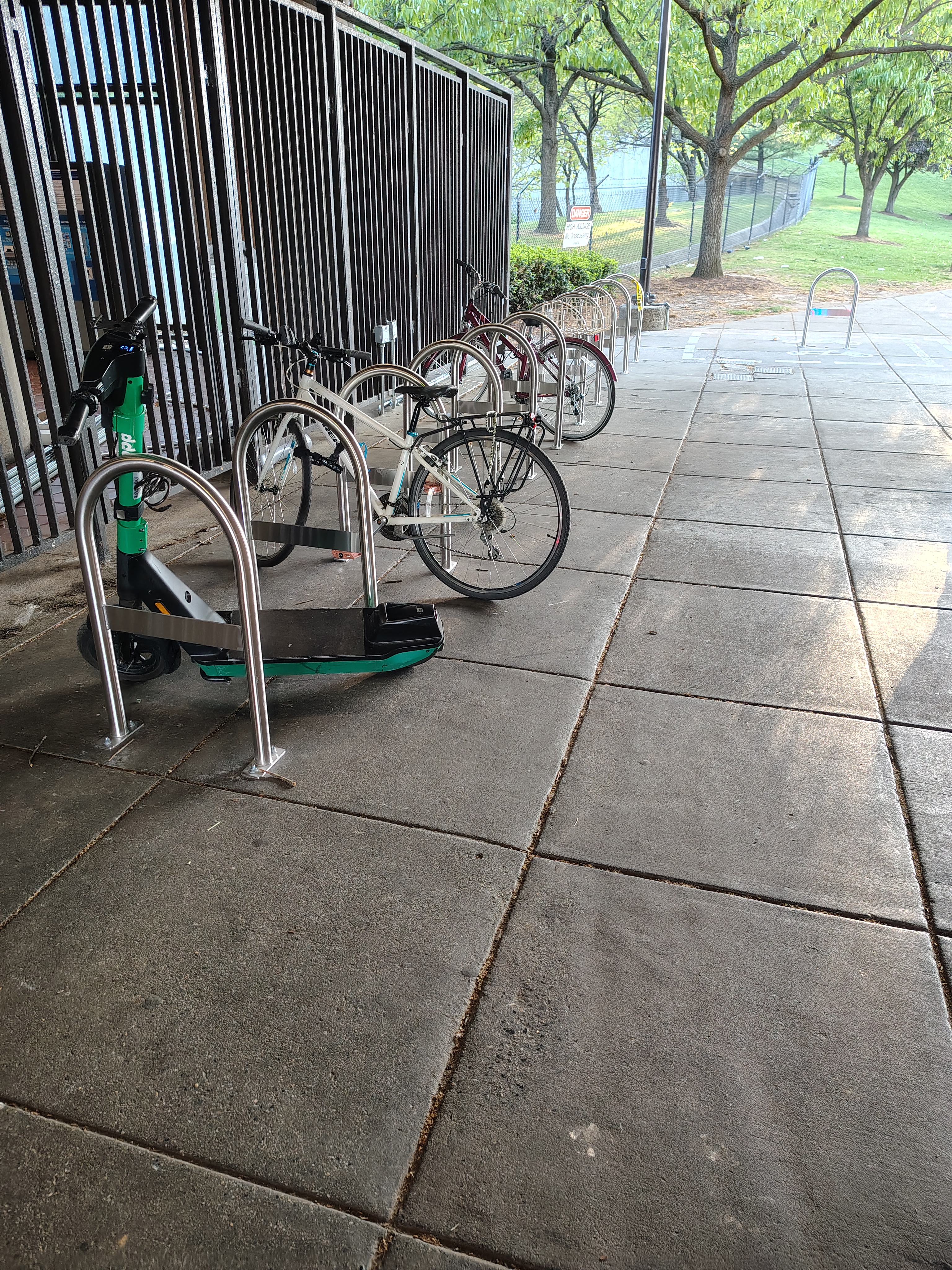
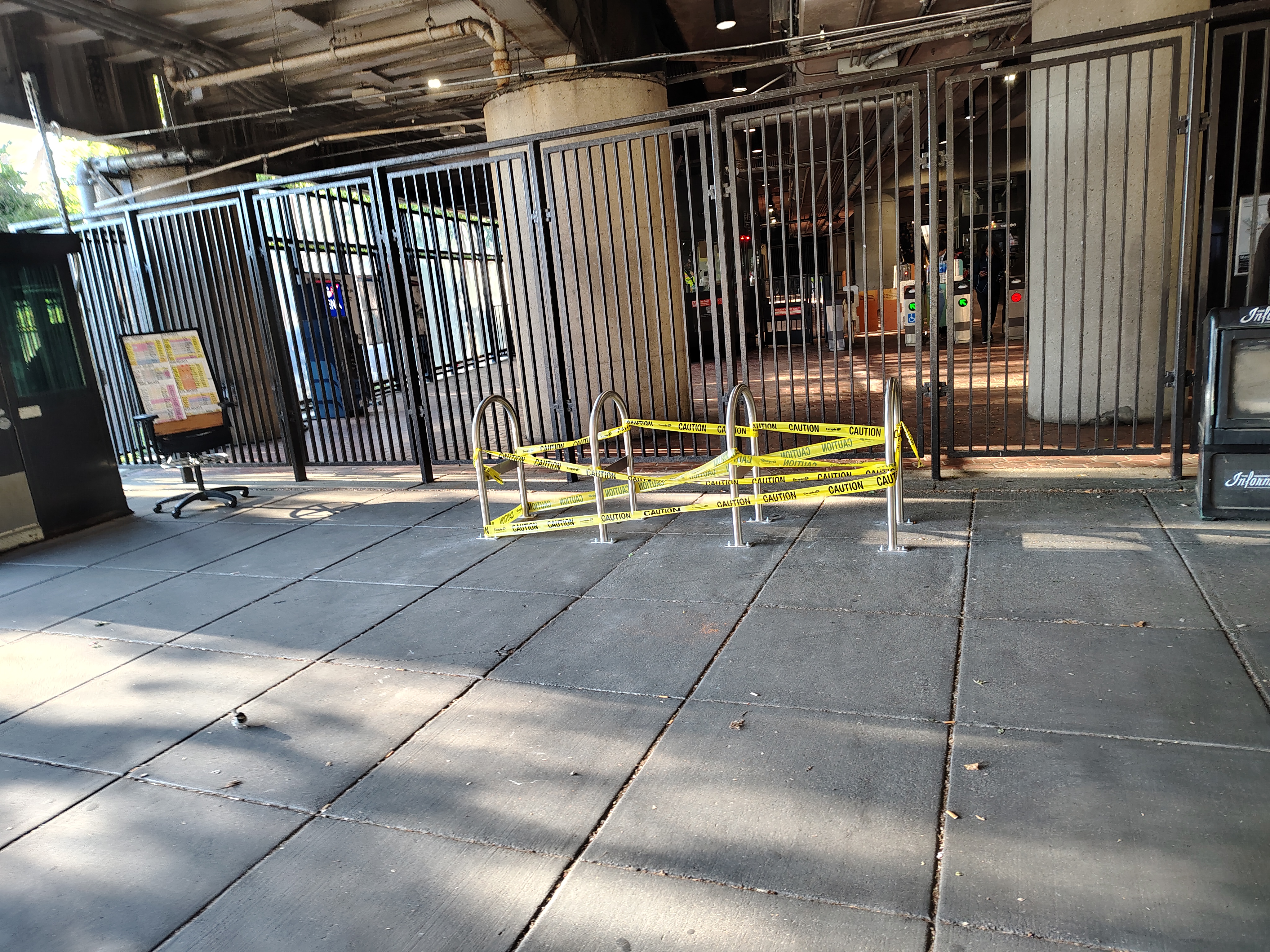
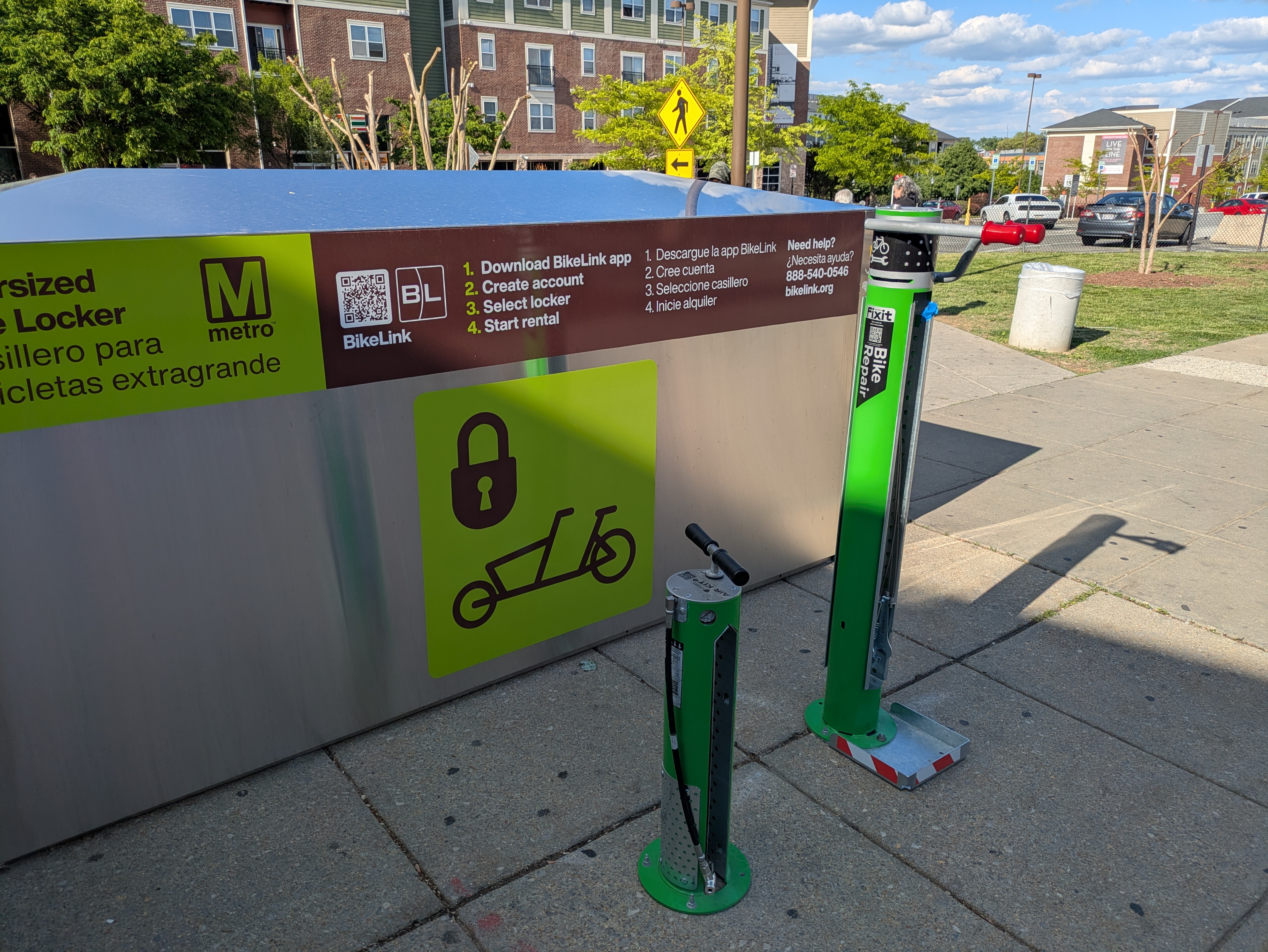
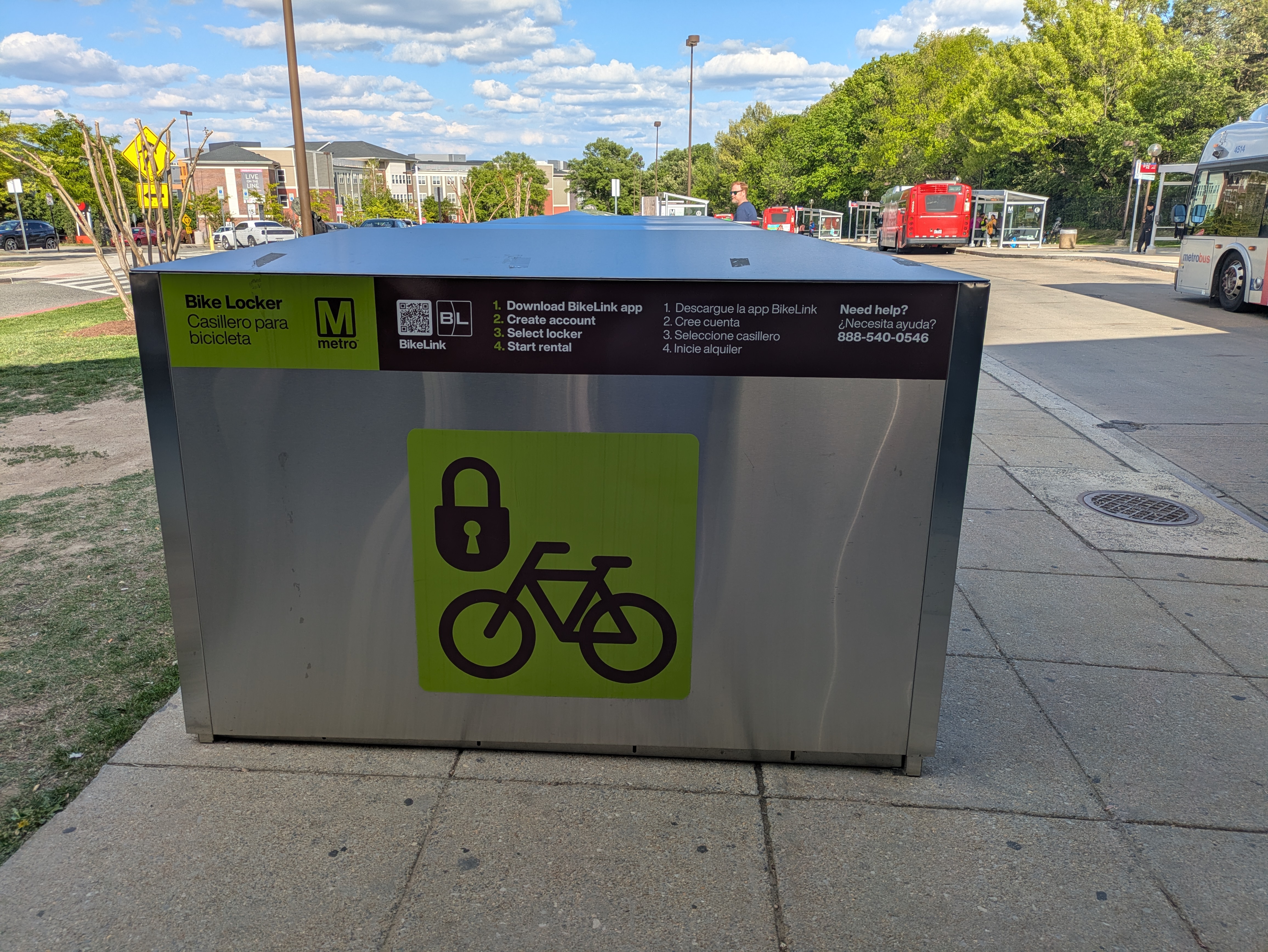
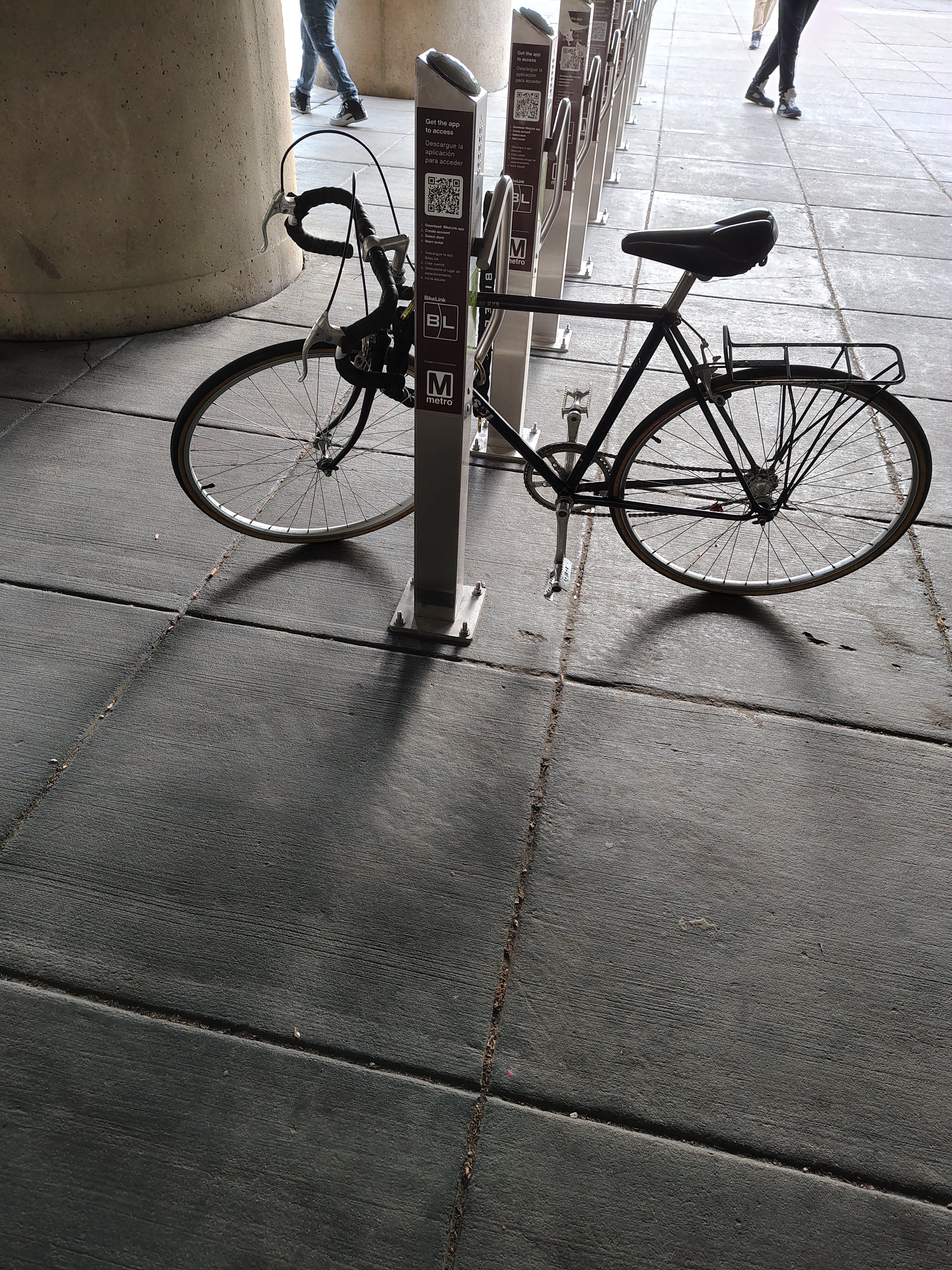
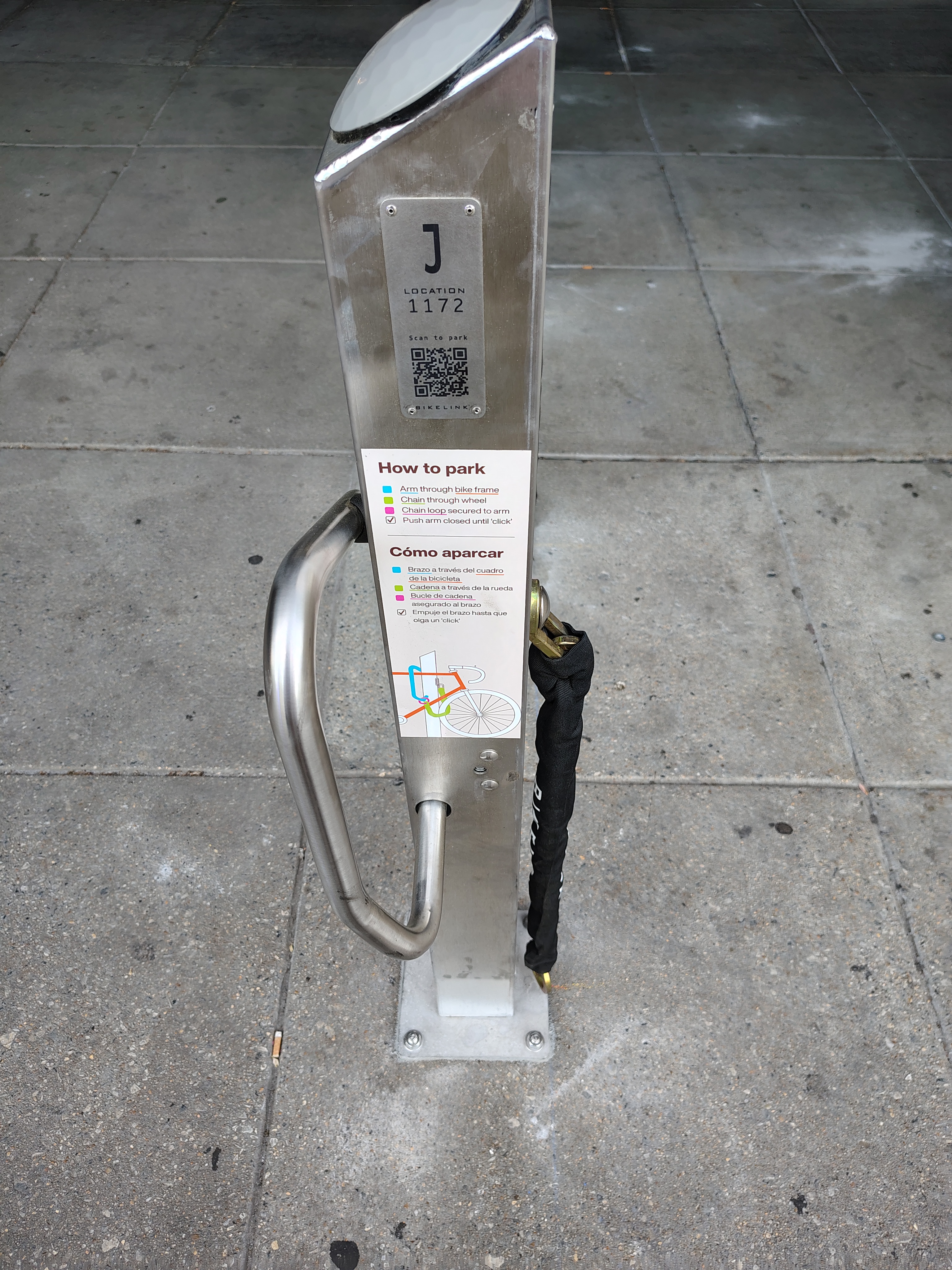
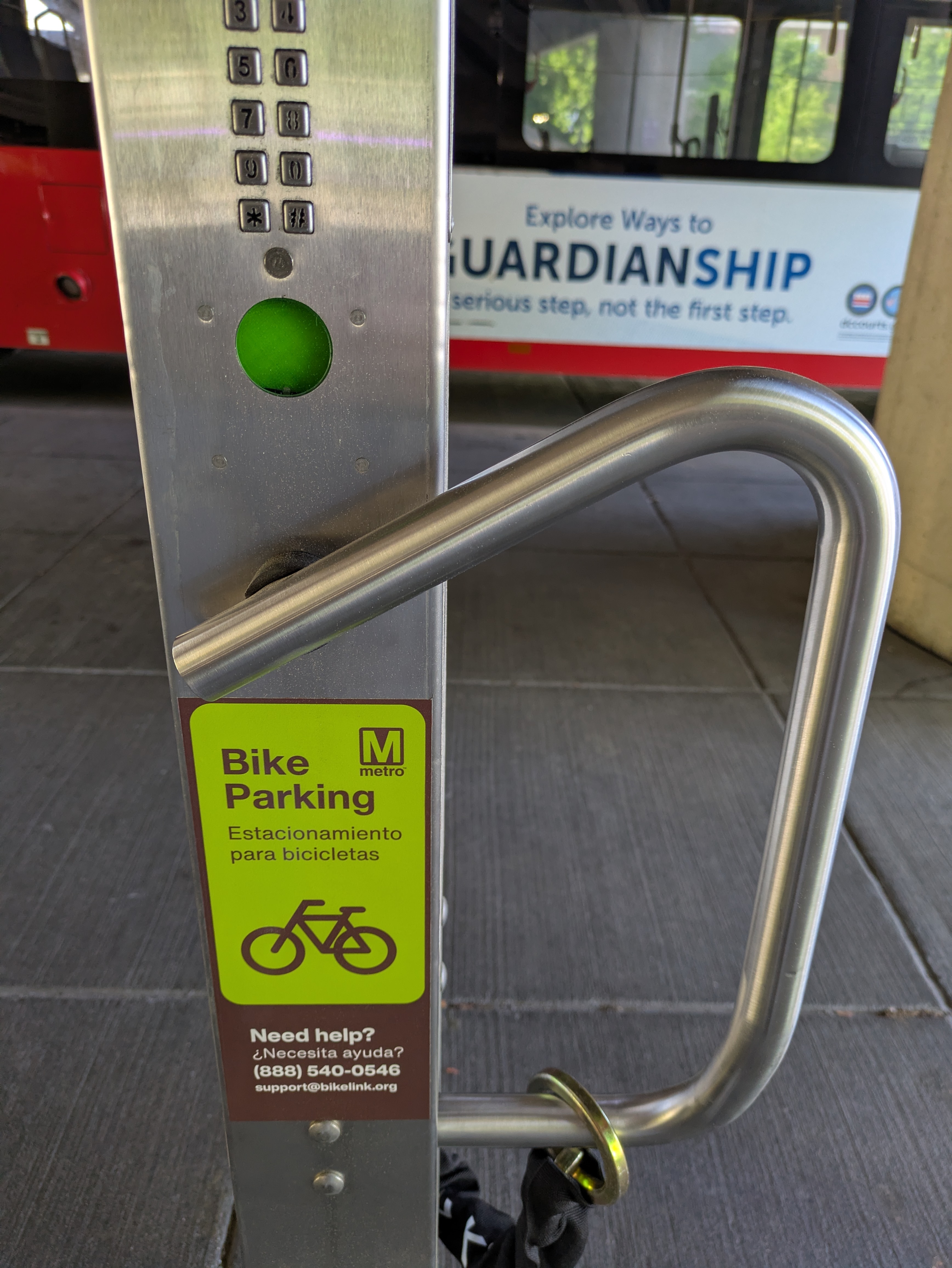
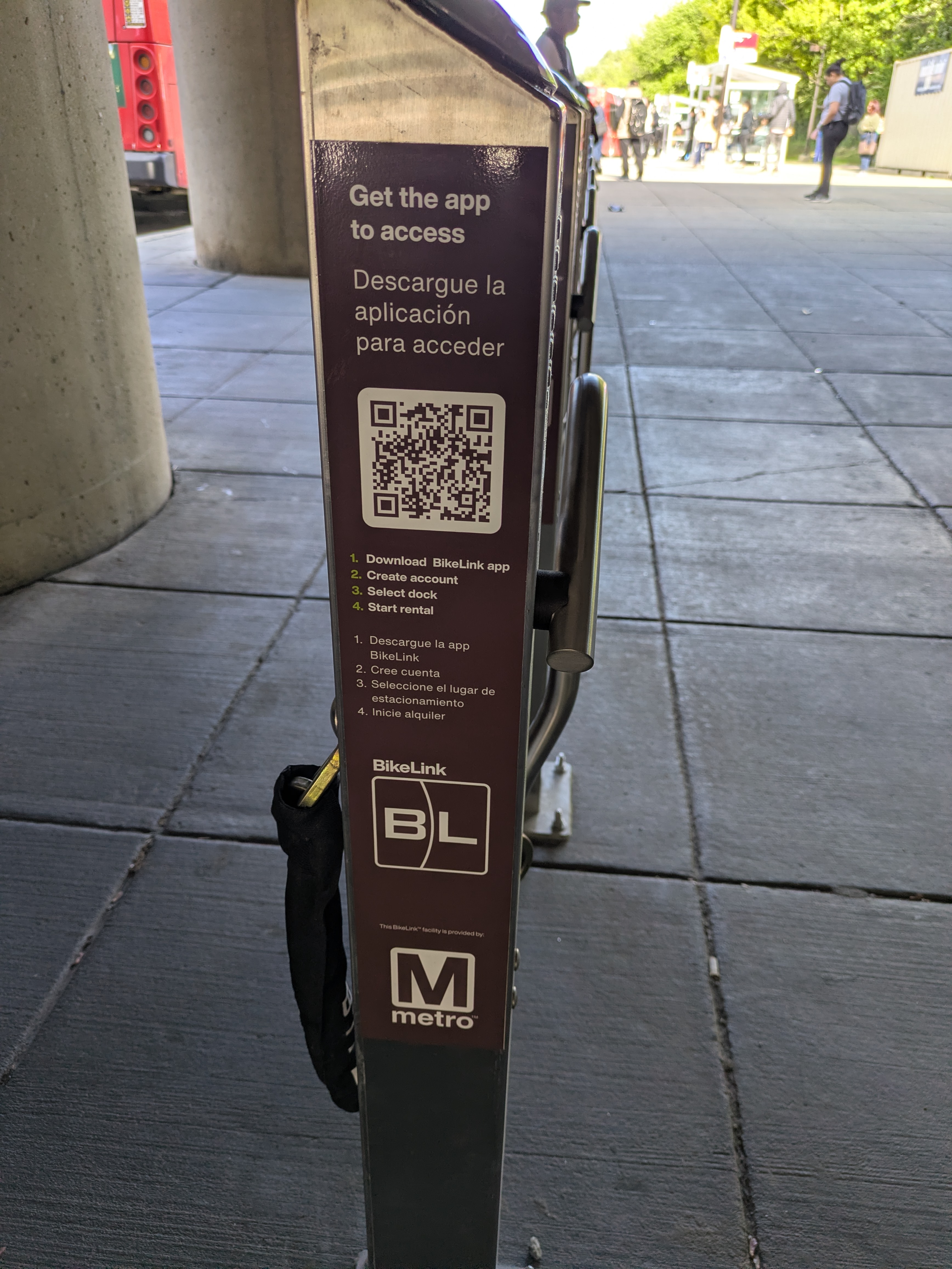
Metro started upgrading bike parking at Fort Totten station a few weeks ago. New bike lockers, “smart” self-locking racks, and standard U-racks will be available, along with a new bike repair station. More information at wmata.com/bikelocker.
Some of the old U-racks have been replaced and are available for use. Old ones in the center median still remain with parked bikes. Bikes must be removed from the old racks by May 8. Updated 5/7/2026: Now bikes must be removed from the old racks by May 18.
Metro recently released a revised FY2027 budget proposal: Metro Revised FY2027 Budget Proposal.
Changes explained by Metro (copied and pasted)
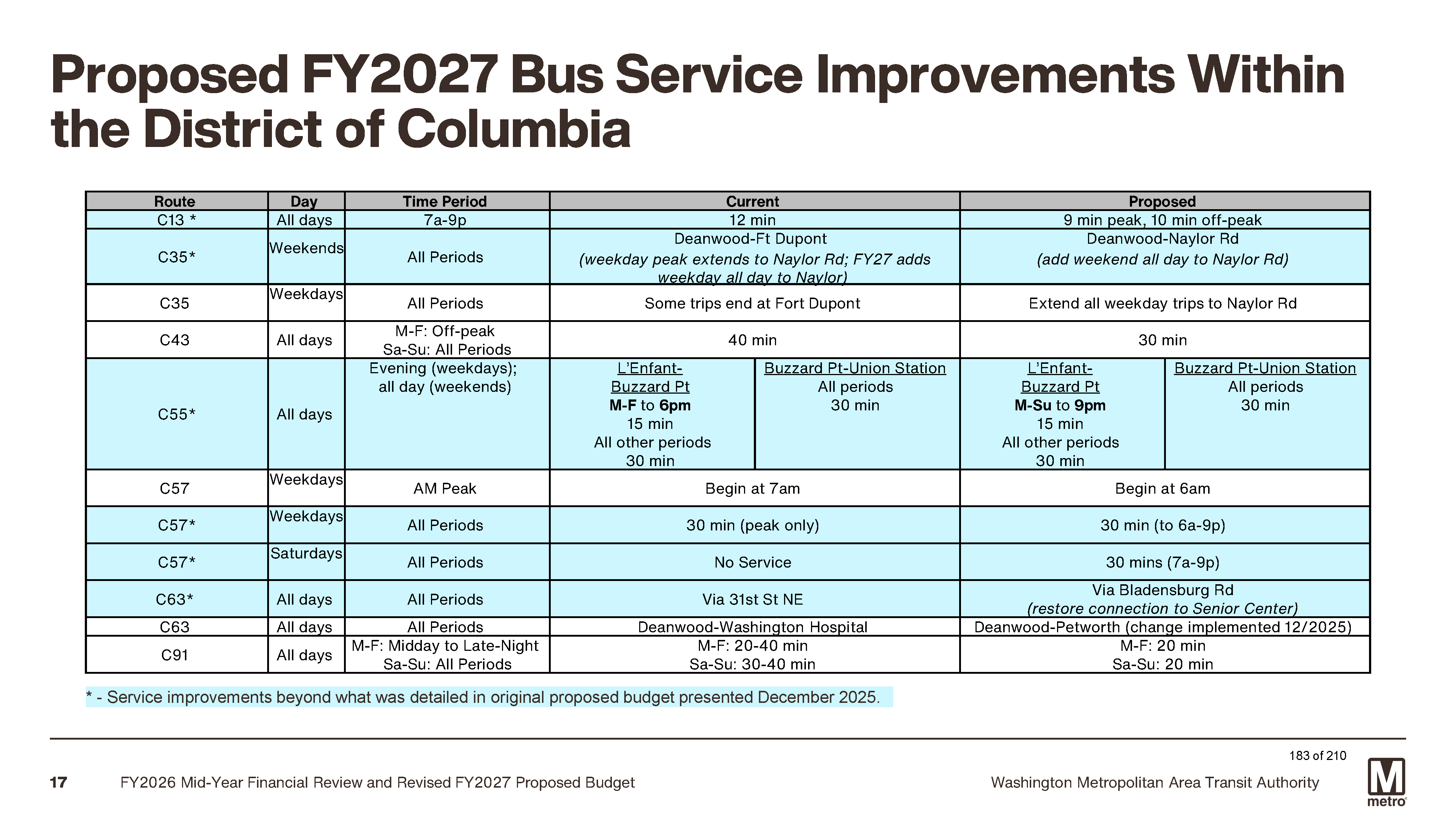
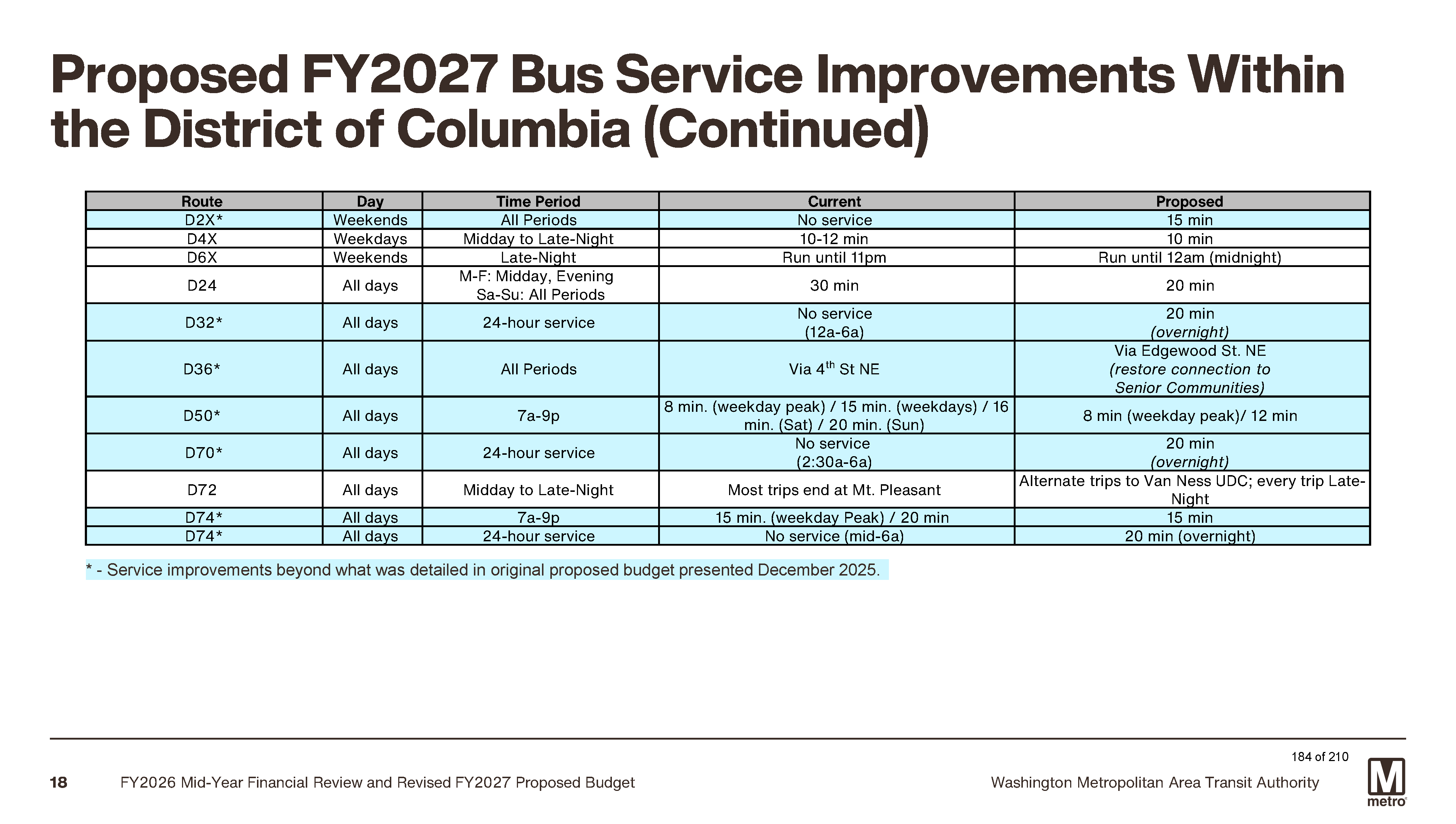
The original FY27 proposed bus service improvements (Nine routes in DC and two in Virginia) are slated to start on or near July 1, 2026.
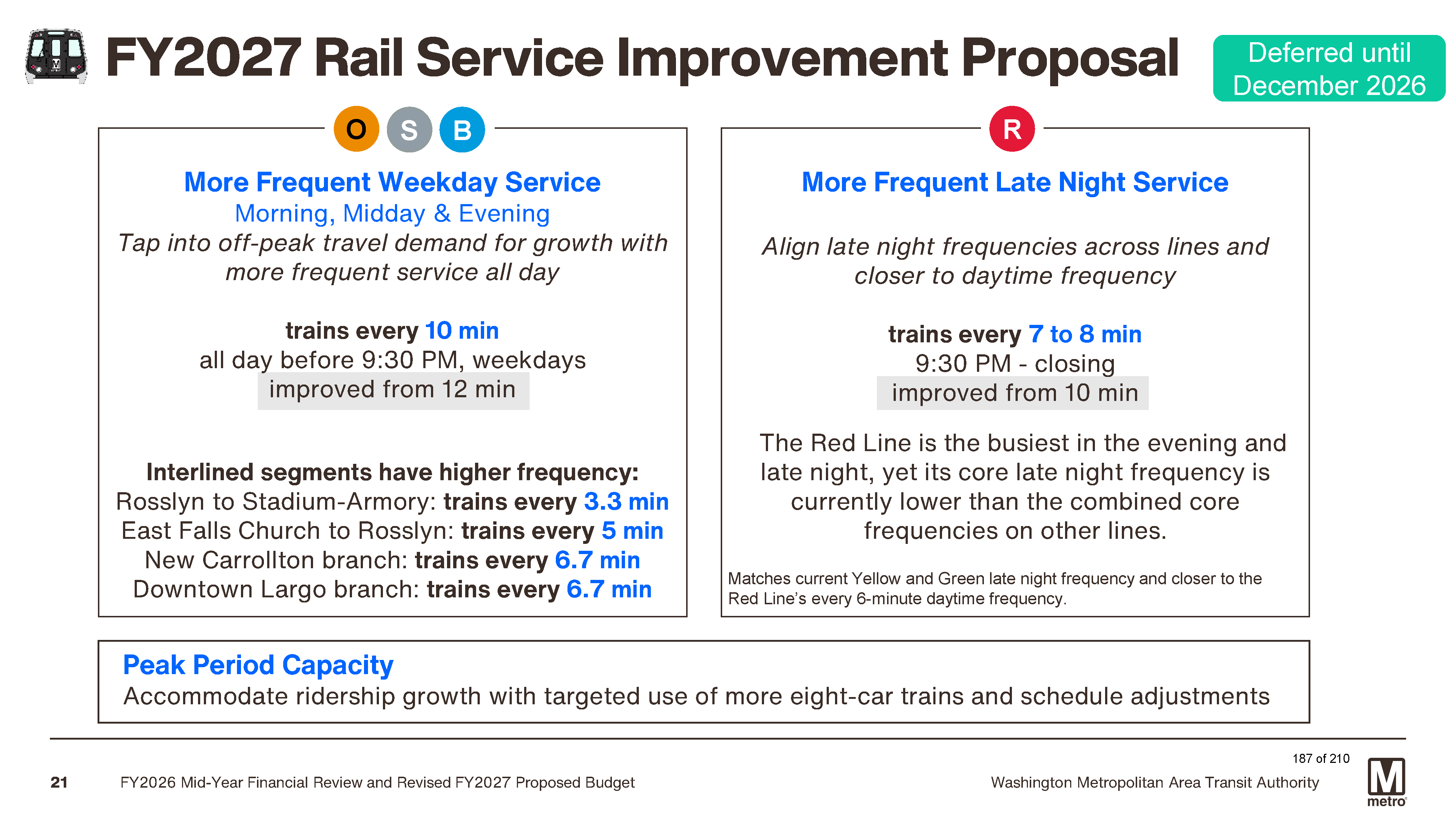
To further support the Better Bus visionary transit network, the following service improvements are being considered for December 2026, pending Board adoption:
More Frequent Weekday Service: Orange, Silver, and Blue Line trains every 10 minutes all day before 9:30 p.m. – an improvement from the current 12-minute headway – to support off peak demand and encourage ridership growth with more frequent all-day service in December 2026.
More Frequent Late-Night Service: Red Line trains every 7 to 9 minutes – improved from every 10 minutes – during late night period from 9:30 p.m. until closing, seven days a week, to boost capacity in both directions for evening travel in December 2026.
$3 per-trip administrative fee for Abilities Ride trips starting July 1, 2026.
The Board of Directors will consider the General Manager’s recommendations and is anticipated to adopt the final FY2027 Budget on April 23, 2026.
ANC Commissioner Danielle Geong (4B09) passed along a notice from DDOT about road repaving that will be starting in the neighborhood in a couple of weeks. Please pay attention to posted signs regarding street parking. Road paving can take 3-5 days to complete.
Also, DDOT has a paving plan dashboard where you can see where DDOT is currently paving and plans to start paving roads, sidewalks, and alleys. In addition, DDOT sends out a weekly construction notice with paving restoration locations. So lots of ways to be aware of upcoming work that may block roads.
Estimated start dates for neighborhood work:
Note that DDOT will be working in nearby Takoma and Manor Park starting the week of March 16 so check out the full list for road paving locations.
ANC Commissioner Danielle Geong (4B09) passed along a letter from DDOT that residents should have received regarding sidewalk work expected to start on March 9, 2026, on Nicholson Street NE from 8th Street to Kennedy Street.
Resident Notification Letter – Nicholson Street NE 8th to Kennedy.
The repairs will include sidewalks, curbs, gutters, and/or wheelchair ramps at Nicholson St NE from 8th St to Kennedy St. The contractor is authorized to work Monday through Saturday, from 7:00 a.m. to 7:00 p.m.
Note that the work may require residents to remove their vehicles from the street so please pay attention to posted signs.
Questions may be directed to Victor Nwabueze at (202) 369-9851 or victor.nwabueze@dc.gov.
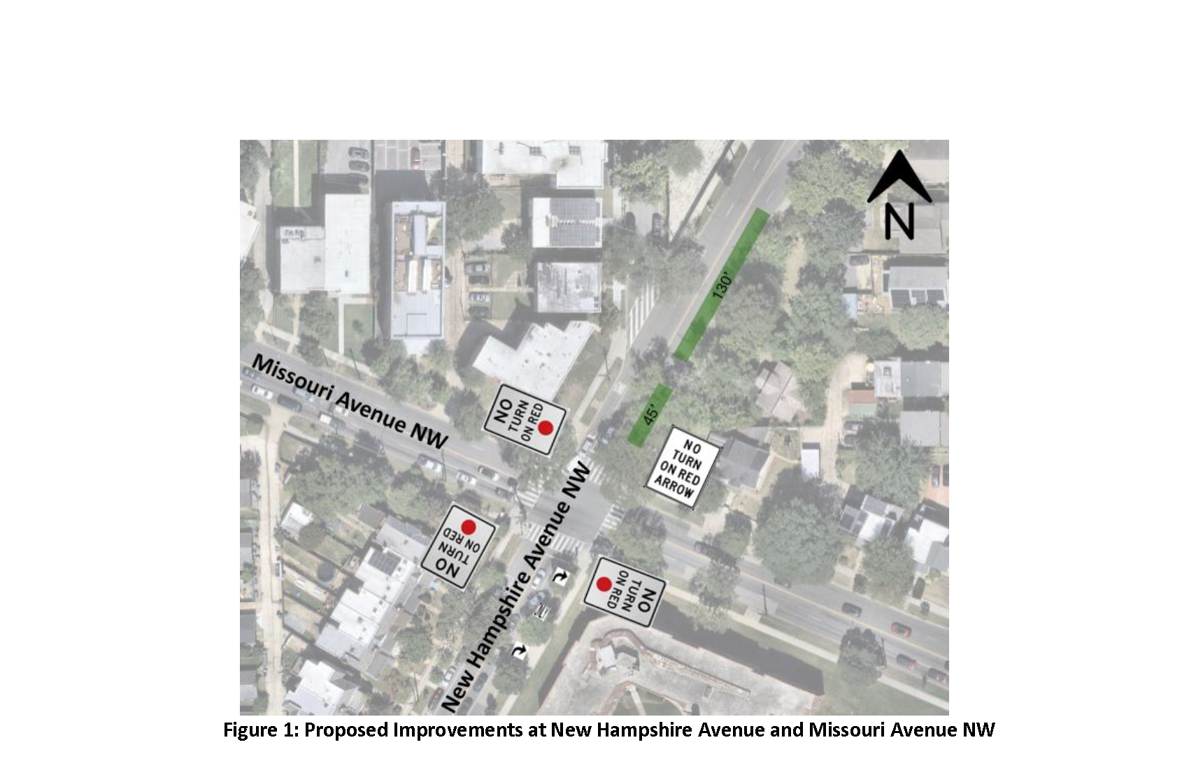
ANC Commissioner Garrett Moore (4B08) shared a Notice of Intent for proposed changes to the intersection of New Hampshire Avenue and Missouri NW (NOI-26-04-MSED).
Document: NOI-26-04-MSED New Hampshire Ave & Missouri Ave NW.
Submit comments on the proposed changes through DDOT’s NOI portal by March 30, 2026.
Proposed changes:
No Turn on Red (NTOR) restriction at New Hampshire Avenue and Missouri Avenue NW (all approaches).
Lane reconfiguration on New Hampshire Ave NW: Currently on New Hampshire Avenue NW northeastbound, the existing right lane allows both through and right-turn movements. This lane will be reconfigured to “right-turn only.”
Parking changes on New Hampshire Avenue NW: Add full time parking spaces on New Hampshire Ave NW northeastbound, north of Missouri Ave NW (see green boxes in Figure 1) as this space is no longer needed to receive through-traffic due to the lane reconfiguration proposal above.
Neighbor Gavin passed along a few tidbits from DDOT’s performance oversight hearing from documents here: https://lims.dccouncil.gov/Hearings/hearings/2113.
Capital Bikeshare: DDOT plans to add a Capital Bikeshare station at/around South Dakota Avenue & Ingraham Street NE in FY26.
Metropolitan Branch Trail, Blair Rd to Piney Branch: DDOT expects to complete the necessary property acquisition from WMATA and advertise the project for construction in FY27, with construction anticipated to begin in Spring 2027.
Metropolitan Branch Trail, 1st Pl NE to Oglethorpe St NW: DDOT is working to procure a consultant to conduct a feasibility study for a trail corridor running parallel to 1st Street NE, from Oglethorpe Street NW to 1st Place NE, beginning in 2026.
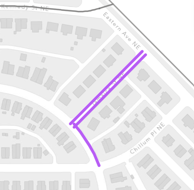
Eastern Avenue NE project: The extent of the shared use path was under review to limit impact to private properties and earthwork. Funds for construction were not included in the FY26 budget. The project is on hold until funds can be provided to finalize the design and construct the project.
In 2026, DDOT plans to build sidewalks where they are currently missing in these neighborhood locations:
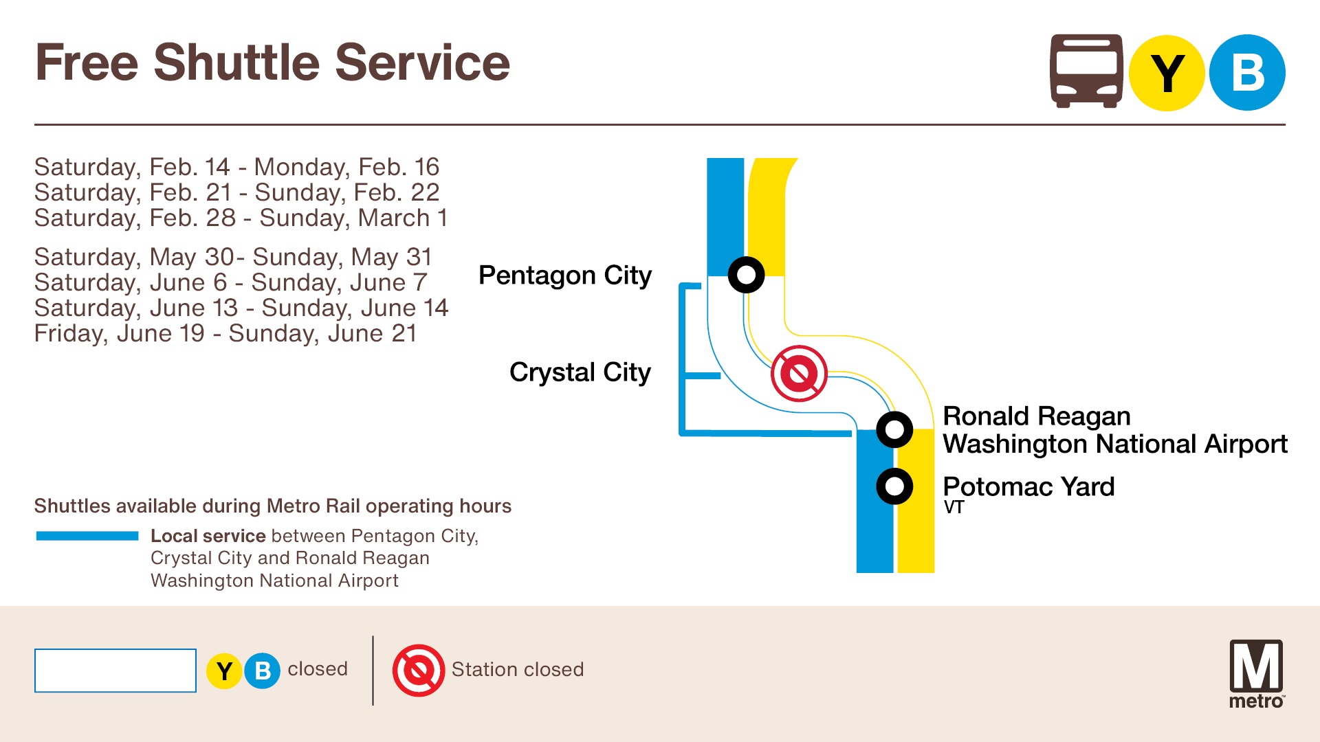
If you usually take the train to National Airport, be aware that Metro has an advisory about train service to the airport on select weekends beginning February 14. Plan extra time to connect to free shuttle buses. Shuttle trips are expected to take approximately 20 minutes depending on traffic.
Crystal City station will be closed, and no trains will run from Pentagon City to National Airport:
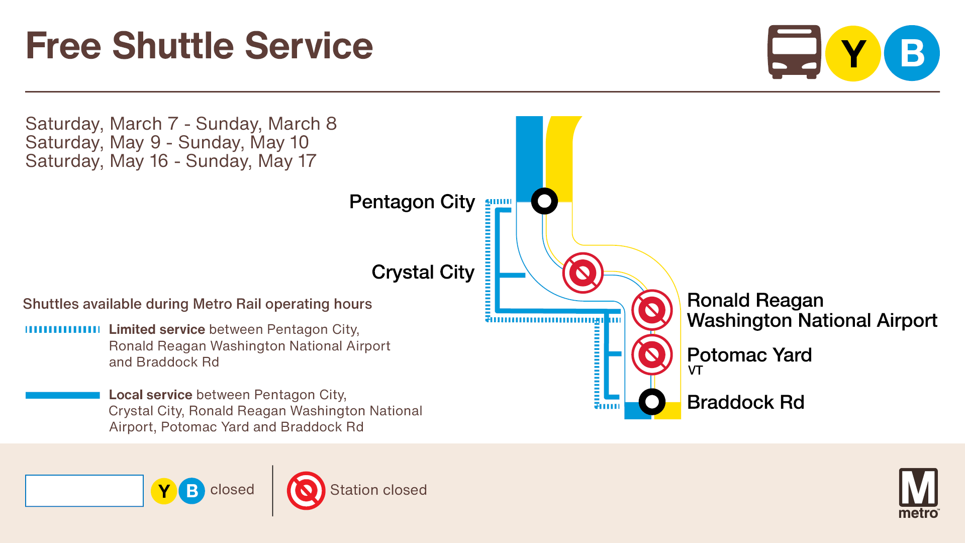
National Airport and Potomac Yard stations will also be closed, and shuttles will extend to Braddock Rd:
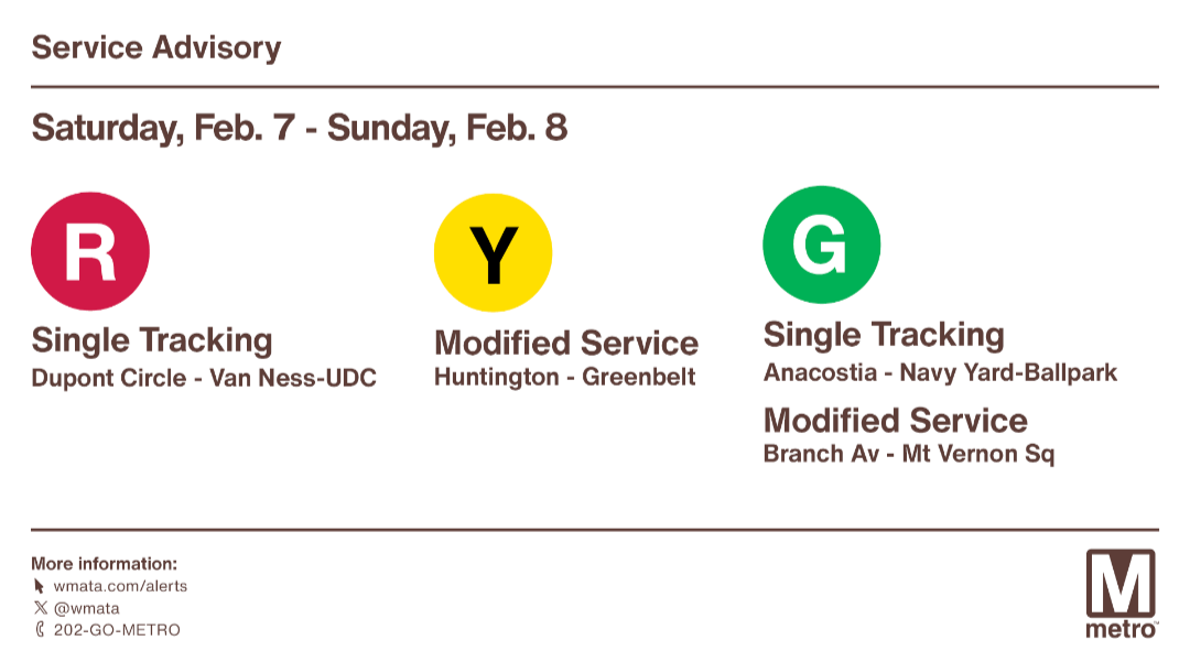
Advisory Effective: 2/7/26 – 2/8/26
Hours: Sat 6 a.m. – 2 a.m.; Sun 6 a.m. – midnight
| Red Line | Trains single track between Dupont Circle and Van Ness. Trains run every 9 min between Farragut North and Glenmont and every 18 minutes between Shady Grove and Glenmont. |
| Orange Line | Normal Service |
| Silver Line | Normal Service |
| Yellow Line | Trains run every 8 minutes between Huntington and Greenbelt. |
| Green Line | Trains single track between Anacostia and Navy Yard. Trains run every 18 minutes between Branch Av and Mt Vernon Sq. |
| Blue Line | Normal Service |
The District Department of Transportation (DDOT) is once again administering the District E-Bike Incentive Program. The application cycle will run February 1, 2026, through February 21, 2026.
This application cycle is open only to District residents enrolled in the Supplemental Nutrition Assistance Program (SNAP), Temporary Assistance for Needy Families (TANF), Medicaid, or the DC Healthcare Alliance.
Eligible residents can apply online at ddot.dc.gov/ebikes or at in-person application events held during the application window at various community partner locations. All applicants must reapply regardless of whether an application was submitted during a previous application cycle. Details about application events will be listed on the District E-Bike Incentive Program’s website.
Selected applicants will receive a voucher of up to $1,500 that can be used toward the purchase of an e-bike, helmet, and bicycle lock at authorized retailers. Recipients will be chosen at random.
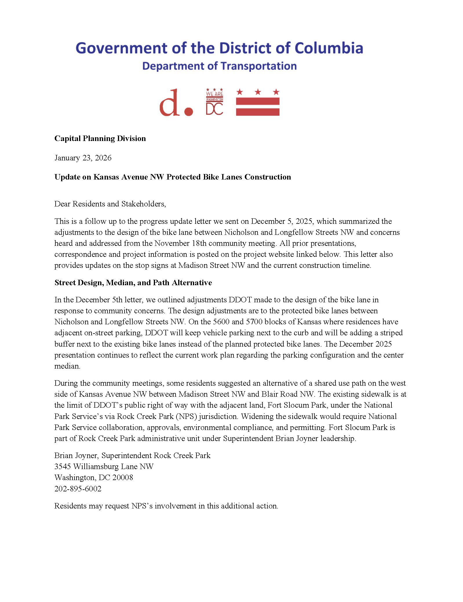
ANC Commissioner Garrett Moore (4B08) shared the latest update on the Kansas Avenue bike lane project from DDOT.
DDOT Kansas Avenue Bike Lane Project Update (January 23, 2026).