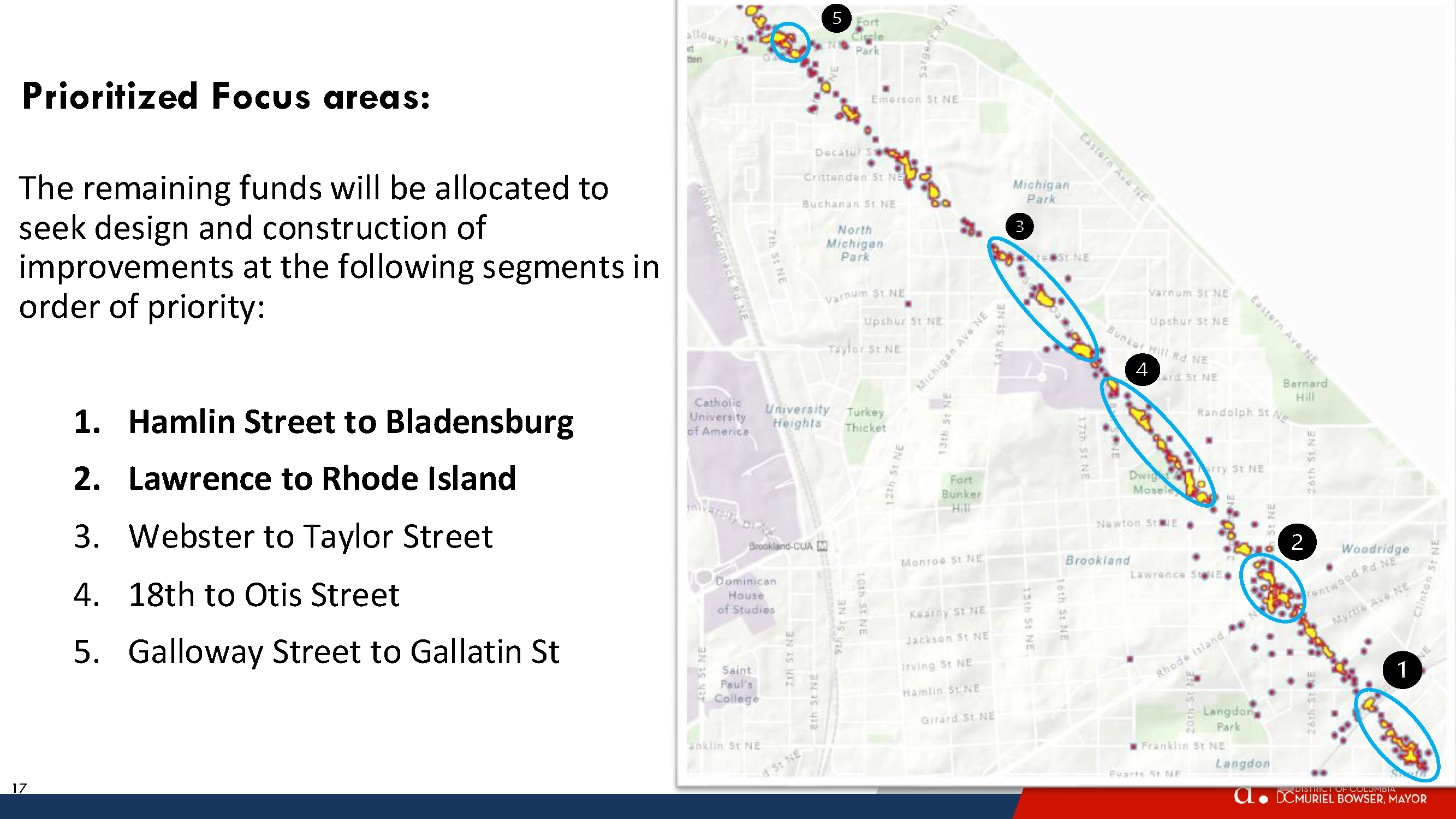
Spot Treatment Locations from Highest to Lowest priority
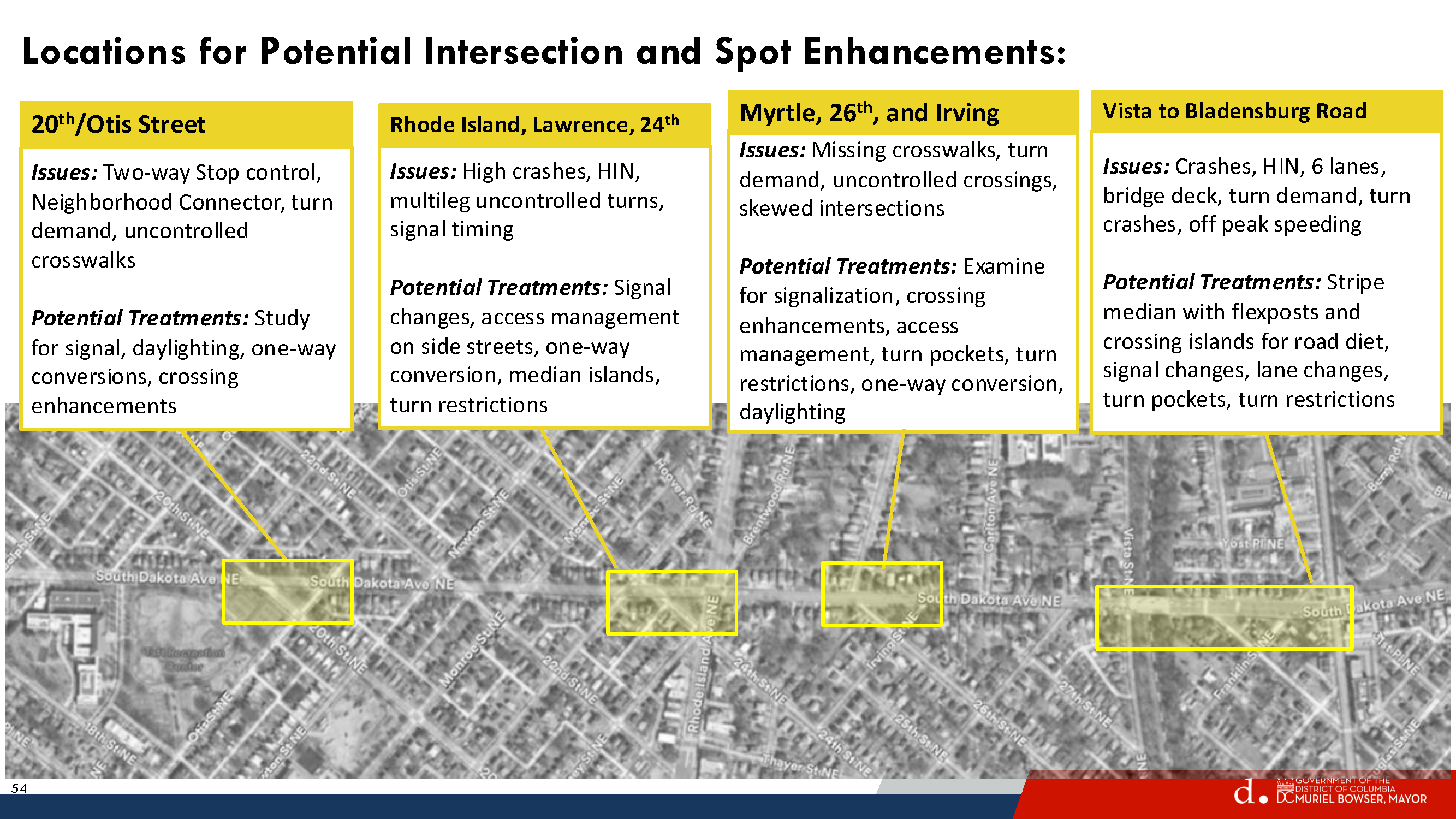
Hamlin Street to Bladensburg
Lawrence to Rhode Island
Webster to Taylor Street
18th to Otis Street
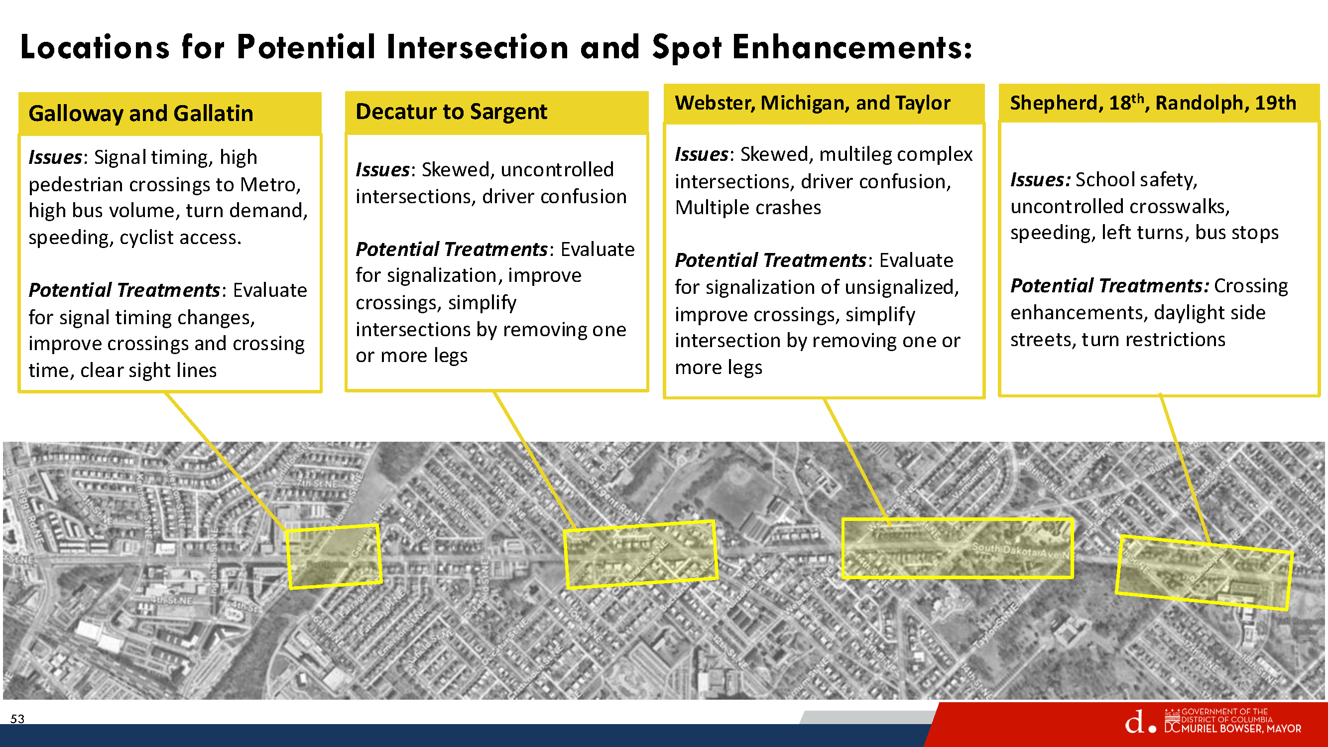
Galloway Street to Gallatin St
Galloway-Gallatin is the only location selected for spot treatment in this neck of the woods. DDOT did not plan to address anything on the northern end, but then Galloway received the most comments and Riggs Road received the second highest number of comments. So DDOT decided to put Galloway-Gallatin at the bottom of the priority list. Everyone, including DDOT, knows that Riggs is a problem but they say that addressing Riggs & South Dakota would be a very capital intensive project that would need support from the Ward 4 councilmember.
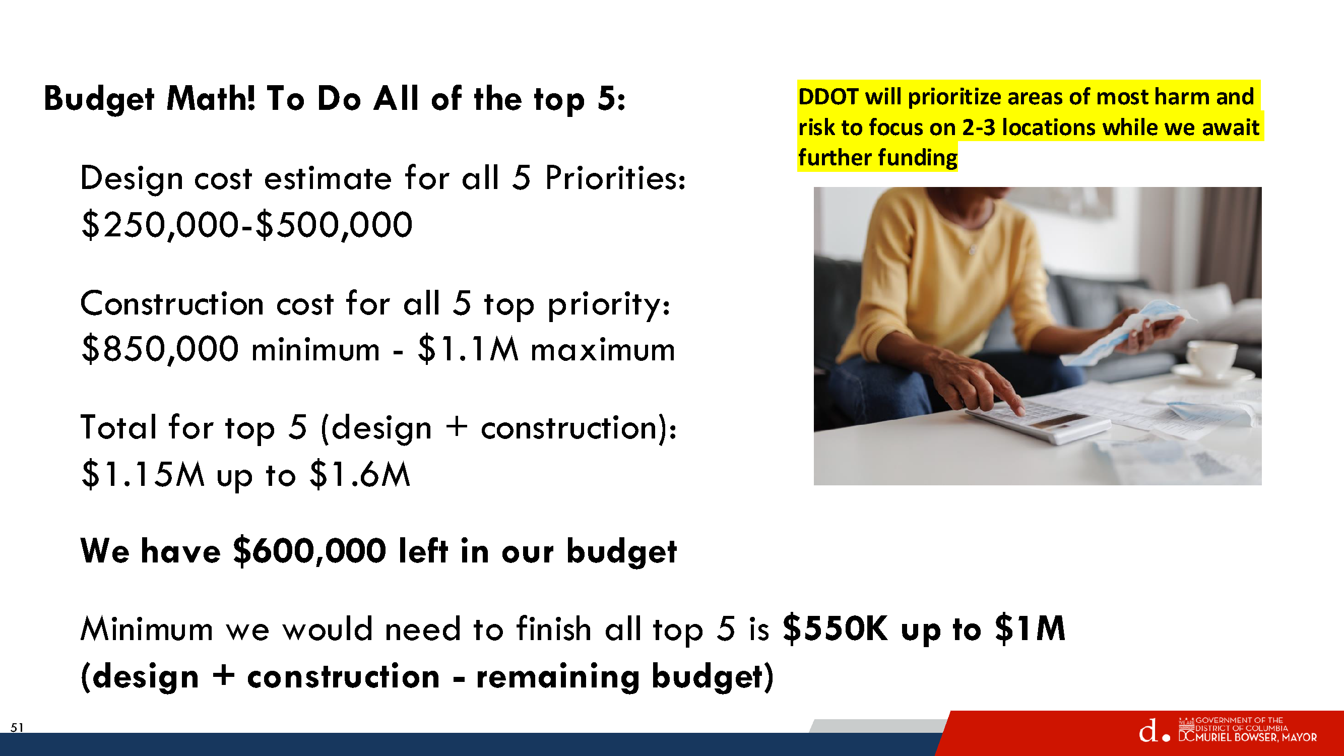
In any case, DDOT has about $600,000 remaining in the South Dakota Avenue corridor project budget, which is enough for just the top one or two priority areas. But Councilmember Zachary Parker’s office seems confident that they can get more money to do all five priority areas if residents really want them to.
So let’s pretend that DDOT will get to the northern end and take a look at what they propose for Galloway-Gallatin.
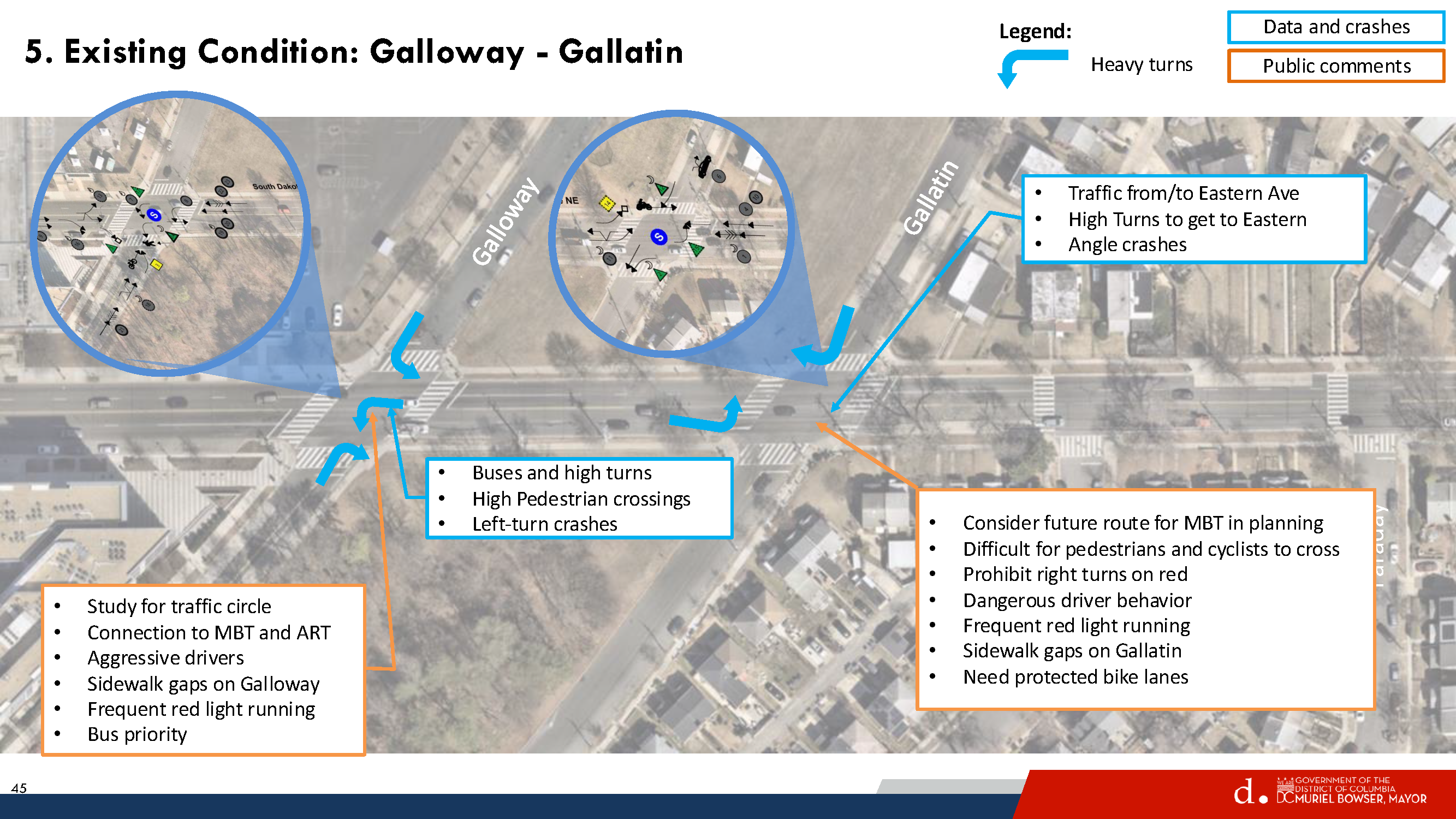
Existing Conditions Galloway-Gallatin
Residents are familiar with existing problems at South Dakota/Galloway and at South Dakota/Gallatin. Galloway gets a lot of traffic. It leads to the Fort Totten station and the Metropolitan Branch Trail, so lots of cars, buses, pedestrians, and people on bikes. The station is a major bus transfer point and lots of students use the station to get to nearby UDC and charter schools or to get on buses to go to schools outside the neighborhood. Gallatin sees less traffic than Galloway, but still gets a fair amount. And Gallatin is envisioned as a future connection to bike trails in Prince George’s County.
Looking at the existing conditions described by DDOT above, note that there is no intention of putting a traffic circle at either Galloway or Gallatin. That was a comment submitted by a resident during the early stages of the project.
Proposed Concept – Gallatin
For Gallatin, DDOT would consider a few things:
Centerline hardening southbound South Dakota to slow down turns
“Stop for Pedestrian while Turning” signs
Daylighting markings on all four corners of Gallatin to improve visibility of crossing pedestrians
Yellow frame around traffic lights so that they are easier to see
This all seems fine enough and would not interfere with potential bike facilities in the future.
Proposed Concept – Galloway
For Galloway Street, DDOT would consider doing a few things:
Northbound South Dakota Avenue
Dedicated left turn lane
Short Median in northbound travel lane would provide safe space for people in middle of crossing, ensure that drivers turn left at Galloway and do not proceed straight, and reduce the number of through lanes in just that one spot.
Center lane hardening
Southbound South Dakota Avenue
Lane markings
Eastbound Galloway Street
Two eastbound travel lanes so that there is a left turn lane for drivers to head northbound on South Dakota Avenue or proceed straight on Galloway and a dedicated right turn lane.
Westbound Galloway Street
One travel lane westbound
Daylighting markings east and west of South Dakota
This post is way too long so TL;DR here – I do not think what is proposed for Galloway makes sense, and I am curious what others think.
The thing that jumped out to me immediately is that the proposal states that DDOT would talk to Metro about removing the eastbound bus stop at Galloway & South Dakota in order to make two eastbound travel lanes on Galloway. I confirmed with DDOT that they were referring to the eastbound stop. In fact, Metro removed that eastbound bus stop during the bus network redesign but that got overlooked by DDOT.
That means the westbound stop on Galloway would remain. There are a lot of cars and buses that make that left turn onto Galloway. Currently, when buses make the turn onto Galloway and stop at that westbound stop (it is used a fair amount), cars are able to go around the bus. If DDOT makes two eastbound travel lanes and one westbound lane, I do not think there will be enough space for cars to go around the stopped bus and that would leave cars hanging out in the intersection trying to make the left turn. That would not be good.
DDOT said maybe they could move the stop further west or create a diversion space around the bus or something. I do not see where else the stop could go that would not create the same problem or become useless given that it is the last stop before the Metro station and moving it closer and closer to the station would eventually make it useless.
Also, I think I can safely say that the buses would not be able to make that turn onto Galloway if the stop bar is at the crosswalk. Moving the stop bar back could provide a better turning radius but then fewer vehicles would get through the intersection to turn left or go straight ahead.
With respect to the dedicated turn lanes westbound Galloway, I do not know that it makes sense to have vehicles traveling straight on Galloway sitting behind vehicles waiting to turn left.
I am also not sure about the treatment for South Dakota Avenue with the short refuge median there.
All of this to say, I am not so sure that the proposal for the Galloway-South Dakota travel lanes make a lot of sense. But I am not an engineer and I have not seen a traffic analysis, so I don’t know, maybe this all could make sense.
Things that I think would make sense:
More time for pedestrians to cross South Dakota at Galloway
Centerline hardening (though I suspect the buses will just run over it)
Daylighting on Galloway east of South Dakota on both sides of the street. Bulbouts here are actually included in UDC’s 2023-2033 Lamond-Riggs campus plan (which is not really moving forward because apparently there is no money or something). UDC’s enrollment at the Lamond-Riggs campus has grown tremendously (which is why they really need funding to proceed with their campus plan, so DC Council really should give them the money to do it!!). Between campus visitors and the youth sports teams that practice on the field across the street from the campus, lots of cars end up being parked right up to the intersection often enough.
I like the idea of dedicated left turn lanes because it is true that waiting for buses/cars to turn left backs up traffic and makes people impatient and they end up running the light regularly enough. But I just do not know that this concept is the way to do it unless maybe they removed the parking lane on Galloway west of South Dakota, which I am reluctant to even type out because I can just see heads exploding. Lots of parents drive to the daycare on Galloway so I can certainly see why people would want some curbside space to drop off and pick up the kiddos.
Also, a 10-foot multi-use path is supposed to be installed on the south side of Galloway between South Dakota and 4th Street, with construction currently anticipated in 2026-2027. This is one of those (federal) projects that keeps getting pushed back year after year for all sorts of reasons. If this does proceed as planned, it might be useful to see how travel patterns for pedestrians and people on bikes change.
None of this will likely do much to slow down the excessive speeding on South Dakota, which was supposed to be the whole point of the corridor project. But we abandoned that goal before we really got started so.
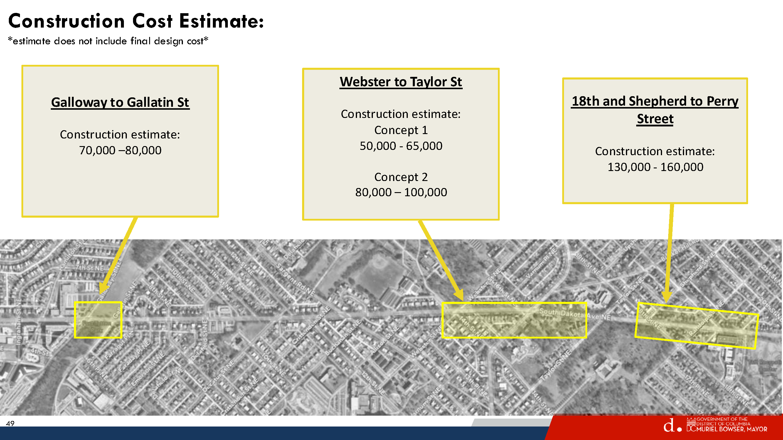
These are just my thoughts. DDOT will not do anything at Galloway-Gallatin unless residents really want them to and ask Councilmember Parker’s office to identify funding to get it done. The cost for Galloway-Gallatin is not that much (roughly $70,000-80,000), so people need to decide what they want to happen or not happen.
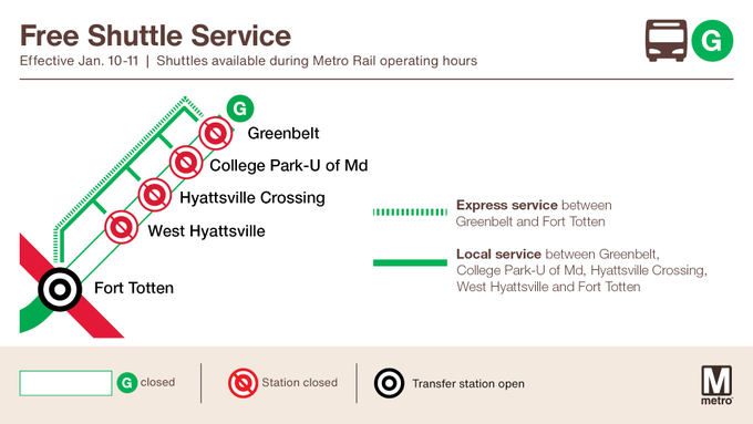
Metrorail weekend service for Saturday, January 10 through Sunday, January 11
Advisory Effective: 1/10/26 – 1/11/26
Hours: Sat 6 a.m. – 2 a.m.; Sun 6 a.m. – midnight
Green Line
Free shuttle buses replace trains between Fort Totten and Greenbelt stations. West Hyattsville, Hyattsville Crossing, College Park U-MD, and Greenbelt stations closed. Trains run every 8 minutes.
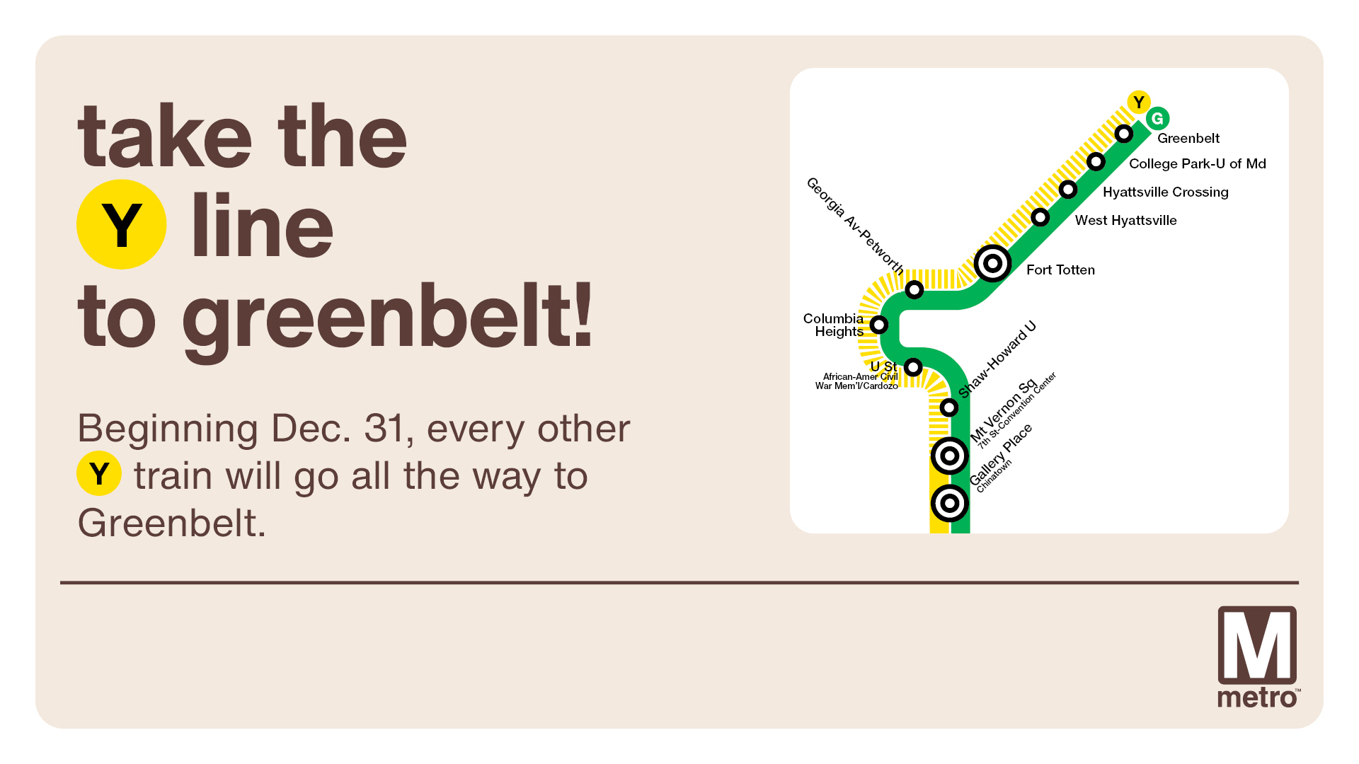
Yellow Line
Modifed service: Trains run every 8 minutes between Huntington and Mt Vernon Sq.
Beginning December 31, 2025, half of Yellow Line trains will operate between Huntington and Greenbelt (every 12-15 mins) and the other half will operate between Huntington & Mt. Vernon Sq (every 6-8 mins).
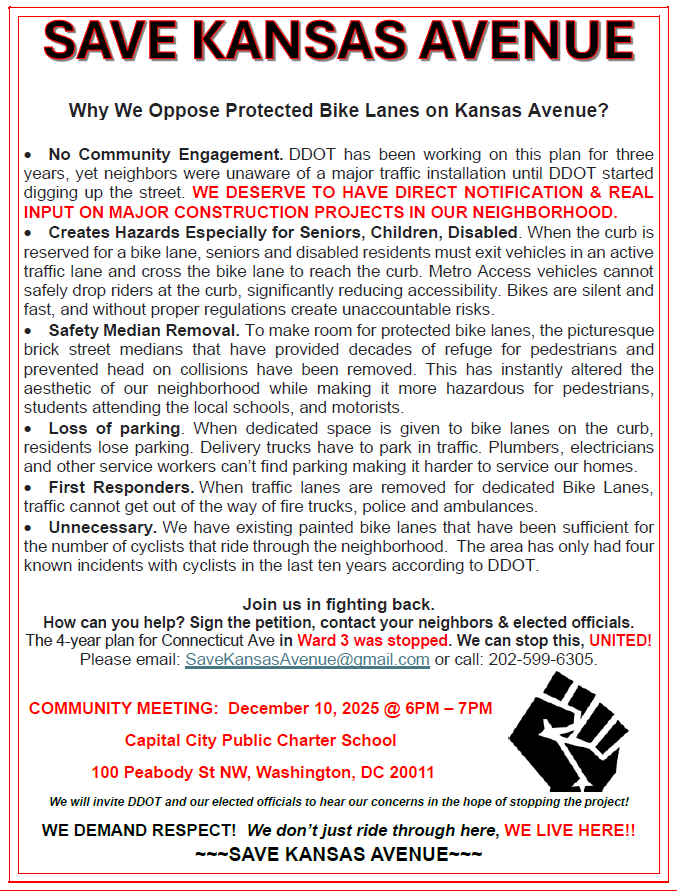
A couple of days ago, I received an email from a group calling itself “Save Kansas Avenue.” They sent this email in response to last week’s post about the updated design for the Kansas Avenue bike lane project. They said they wanted to share information from the perspective of some of the directly impacted residents, and they passed along the flyer created for the community meeting organized on December 10. Primarily they say that DDOT did not do sufficient community engagement over the life of this project and that many residents were not aware of this project until after construction began a few weeks ago.
(I published a post about the Notice of Intent for this project back in 2022. The NOI is the point when the public weighs in. I do not know what kind of outreach was done at that point and over the years to let people know about this project. I also published a post in September of this year with an update about the construction timeline that was slated for October. Again, I do not know what kind of outreach was done at that point to convey the construction timeline. The email from the Save Kansas Avenue group stated that over the past three years, DDOT has engaged only with ANC commissioners and the charter schools in the area (and they say that the charter schools are opposed to the protected bike lanes) and that residents did not get any notice about construction before it started.)
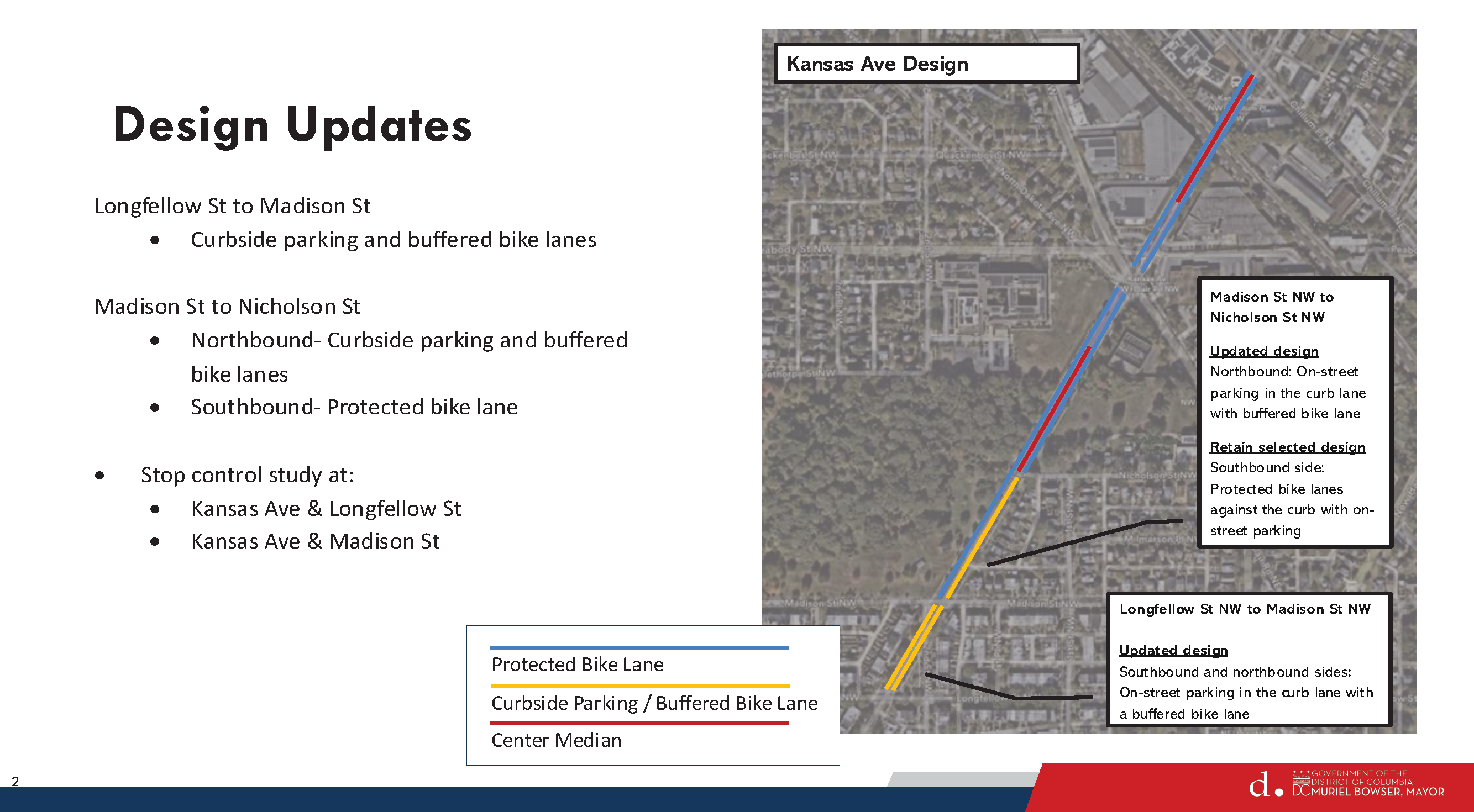
On December 5, DDOT provided detailed responses to resident concerns in a letter (linked in last week’s blog post) explaining what design changes the agency planned to make. Residents organized a community meeting on December 10 where DDOT gave a presentation about the updated design. I did not attend that meeting. The presentation is available on the Kansas Avenue bike lane project website.
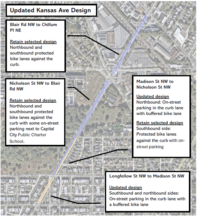
Updated Kansas Avenue bike lane design, December 10, 2025.
The Save Kansas Avenue group wanted to let me know that even with DDOT’s updated design they are still against the project. They wrote:
[T]he community is still against it because of the hazardous conditions it has caused with the removal of the street medians to accommodate the bike lanes. Additionally, we see a great opportunity with the city by instead of installing protected bike lanes, the city could install a multi use trail at the Fort Slocum Park by expanding the sidewalk by 4 feet. This would not only accommodate pedestrians and cyclists, but also tie it to the adjacent Metro Branch Trail and would be better for the local community.
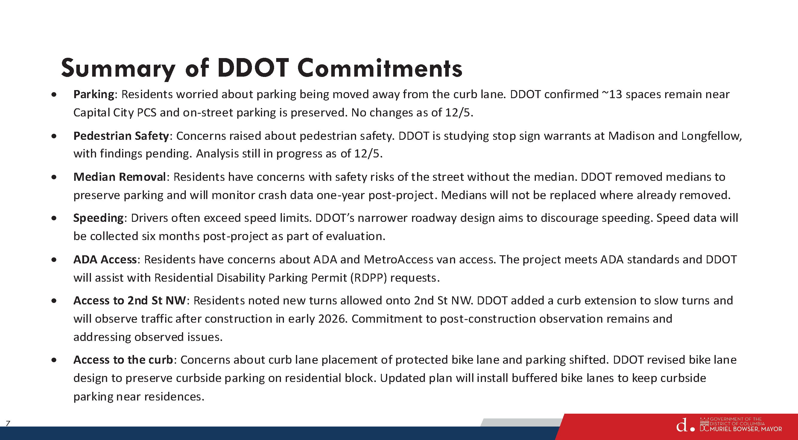
Summary of DDOT’s commitments from December 10, 2025, presentation.
Included in the December 10th presentation is a slide about DDOT’s commitments going forward. Unclear what will ultimately happen given the continued concerns from these residents.
Construction on the Green Line will cause single-tracking between U St and Georgia Av-Petworth starting at 10 p.m. on Tuesday, Dec. 16 through system closing Tuesday, Dec. 30.
Customers are encouraged to plan ahead and allow additional travel time.
All stations will remain open. However, wait times will be longer than usual with Green Line trains running every 16 minutes all day. Yellow Line trains will run every 8 minutes all day between Mt. Vernon Square and Huntington during the construction period.
Customers also have several bus options as alternatives, including the D40 and D4X along Georgia Avenue NW, the D50 and D5X along 14th Street NW, the D60 and D6X along 16th Street NW, the C51 and C53 along U Street NW, and the C61 along Columbia Road/Irving Street NW.
Metro is doing critical work to improve safety and reliability, including replacing rail and fastening systems, renewing communications and signal equipment, and restoring lighting infrastructure. For more information, visit the winter major construction page.
Metro scheduled this work during the holiday season, when ridership is typically lower, to minimize impacts on customers.
Starting Dec. 31: Yellow Line to Greenbelt
Once construction ends, the Yellow Line extension to Greenbelt will begin on Dec. 31. Half of the Yellow Line trains will operate between Huntington and Greenbelt, and the other half will operate between Huntington and Mt. Vernon Square.
Trip Planning Resources
Customers are encouraged to use MetroPulse or wmata.com for real-time service information, sign up for MetroAlerts, or check @wmata, @metrorailinfo, and @metrobusinfo on social media for updates. Customers can also call 202-GO-METRO (202-466-3876, TTY 202-962-2033), M-F, 7 am-8 pm; Sat-Sun, 8 am-8 pm. Automated information is available 24/7. View our planned track work at wmata.com/trackwork.
Spot Treatment Locations from Highest to Lowest priority
Hamlin Street to Bladensburg
Lawrence to Rhode Island
Webster to Taylor Street
18th to Otis Street
Galloway Street to Gallatin St
Galloway-Gallatin is the only location selected for spot treatment in this neck of the woods. DDOT did not plan to address anything on the northern end, but then Galloway received the most comments and Riggs Road received the second highest number of comments. So DDOT decided to put Galloway-Gallatin at the bottom of the priority list. Everyone, including DDOT, knows that Riggs is a problem but they say that addressing Riggs & South Dakota would be a very capital intensive project that would need support from the Ward 4 councilmember.
In any case, DDOT has about $600,000 remaining in the South Dakota Avenue corridor project budget, which is enough for just the top one or two priority areas. But Councilmember Zachary Parker’s office seems confident that they can get more money to do all five priority areas if residents really want them to.
So let’s pretend that DDOT will get to the northern end and take a look at what they propose for Galloway-Gallatin.
Existing Conditions Galloway-Gallatin
Residents are familiar with existing problems at South Dakota/Galloway and at South Dakota/Gallatin. Galloway gets a lot of traffic. It leads to the Fort Totten station and the Metropolitan Branch Trail, so lots of cars, buses, pedestrians, and people on bikes. The station is a major bus transfer point and lots of students use the station to get to nearby UDC and charter schools or to get on buses to go to schools outside the neighborhood. Gallatin sees less traffic than Galloway, but still gets a fair amount. And Gallatin is envisioned as a future connection to bike trails in Prince George’s County.
Looking at the existing conditions described by DDOT above, note that there is no intention of putting a traffic circle at either Galloway or Gallatin. That was a comment submitted by a resident during the early stages of the project.
Proposed Concept – Gallatin
For Gallatin, DDOT would consider a few things:
Centerline hardening southbound South Dakota to slow down turns
“Stop for Pedestrian while Turning” signs
Daylighting markings on all four corners of Gallatin to improve visibility of crossing pedestrians
Yellow frame around traffic lights so that they are easier to see
This all seems fine enough and would not interfere with potential bike facilities in the future.
Proposed Concept – Galloway
For Galloway Street, DDOT would consider doing a few things:
Northbound South Dakota Avenue
Dedicated left turn lane
Short Median in northbound travel lane would provide safe space for people in middle of crossing, ensure that drivers turn left at Galloway and do not proceed straight, and reduce the number of through lanes in just that one spot.
Center lane hardening
Southbound South Dakota Avenue
Lane markings
Eastbound Galloway Street
Two eastbound travel lanes so that there is a left turn lane for drivers to head northbound on South Dakota Avenue or proceed straight on Galloway and a dedicated right turn lane.
Westbound Galloway Street
One travel lane westbound
Daylighting markings east and west of South Dakota
This post is way too long so TL;DR here – I do not think what is proposed for Galloway makes sense, and I am curious what others think.
The thing that jumped out to me immediately is that the proposal states that DDOT would talk to Metro about removing the eastbound bus stop at Galloway & South Dakota in order to make two eastbound travel lanes on Galloway. I confirmed with DDOT that they were referring to the eastbound stop. In fact, Metro removed that eastbound bus stop during the bus network redesign but that got overlooked by DDOT.
That means the westbound stop on Galloway would remain. There are a lot of cars and buses that make that left turn onto Galloway. Currently, when buses make the turn onto Galloway and stop at that westbound stop (it is used a fair amount), cars are able to go around the bus. If DDOT makes two eastbound travel lanes and one westbound lane, I do not think there will be enough space for cars to go around the stopped bus and that would leave cars hanging out in the intersection trying to make the left turn. That would not be good.
DDOT said maybe they could move the stop further west or create a diversion space around the bus or something. I do not see where else the stop could go that would not create the same problem or become useless given that it is the last stop before the Metro station and moving it closer and closer to the station would eventually make it useless.
Also, I think I can safely say that the buses would not be able to make that turn onto Galloway if the stop bar is at the crosswalk. Moving the stop bar back could provide a better turning radius but then fewer vehicles would get through the intersection to turn left or go straight ahead.
With respect to the dedicated turn lanes westbound Galloway, I do not know that it makes sense to have vehicles traveling straight on Galloway sitting behind vehicles waiting to turn left.
I am also not sure about the treatment for South Dakota Avenue with the short refuge median there.
All of this to say, I am not so sure that the proposal for the Galloway-South Dakota travel lanes make a lot of sense. But I am not an engineer and I have not seen a traffic analysis, so I don’t know, maybe this all could make sense.
Things that I think would make sense:
More time for pedestrians to cross South Dakota at Galloway
Centerline hardening (though I suspect the buses will just run over it)
Daylighting on Galloway east of South Dakota on both sides of the street. Bulbouts here are actually included in UDC’s 2023-2033 Lamond-Riggs campus plan (which is not really moving forward because apparently there is no money or something). UDC’s enrollment at the Lamond-Riggs campus has grown tremendously (which is why they really need funding to proceed with their campus plan, so DC Council really should give them the money to do it!!). Between campus visitors and the youth sports teams that practice on the field across the street from the campus, lots of cars end up being parked right up to the intersection often enough.
I like the idea of dedicated left turn lanes because it is true that waiting for buses/cars to turn left backs up traffic and makes people impatient and they end up running the light regularly enough. But I just do not know that this concept is the way to do it unless maybe they removed the parking lane on Galloway west of South Dakota, which I am reluctant to even type out because I can just see heads exploding. Lots of parents drive to the daycare on Galloway so I can certainly see why people would want some curbside space to drop off and pick up the kiddos.
Also, a 10-foot multi-use path is supposed to be installed on the south side of Galloway between South Dakota and 4th Street, with construction currently anticipated in 2026-2027. This is one of those (federal) projects that keeps getting pushed back year after year for all sorts of reasons. If this does proceed as planned, it might be useful to see how travel patterns for pedestrians and people on bikes change.
None of this will likely do much to slow down the excessive speeding on South Dakota, which was supposed to be the whole point of the corridor project. But we abandoned that goal before we really got started so.
These are just my thoughts. DDOT will not do anything at Galloway-Gallatin unless residents really want them to and ask Councilmember Parker’s office to identify funding to get it done. The cost for Galloway-Gallatin is not that much (roughly $70,000-80,000), so people need to decide what they want to happen or not happen.
Thanks to Washington Area Bicyclist Association (WABA) for sharing information about DDOT’s December 5, 2025, update for the Kansas Avenue bike lane project.
DDOT originally planned to install fully protected bike lanes on Kansas Avenue from Longfellow Street NW to Chillum Place NE. The updated design will have buffered bike lanes in certain sections to preserve curbside parking.
WABA notes that Kansas Avenue is classified as a minor arterial road and according to DDOT policy, “[a]ny bicycle facilities planned for minor arterial streets will be fully-protected facilities (per NACTO/FHWA guidance).” So the updated design will be a bit of a departure from DDOT policy.
DDOT plans to attend a community-organized meeting on December 10, 2025, at 6pm at Capital City Public Charter School.
The District Department of Transportation (DDOT) invites you to a Ward 5 public workshop for the Strategic Bikeways Plan project. This in-person workshop will be held on Tuesday, December 9 from 6p to 8p at Bunker Hill Elementary at 1401 Michigan Avenue NE. The project team will be presenting results from its evaluation of existing conditions and will be inviting community members and stakeholders to share feedback on the project team’s work to date, bicycle transportation needs, safety concerns, key gaps in the bicycle network, potential project ideas, and other local considerations.
The District Department of Transportation (DDOT), in partnership with Ward 5 Councilmember Zachary Parker, invites you to attend public meetings for the South Dakota Avenue Corridor Safety Project from Riggs Road NE to Bladensburg Road NE. DDOT will be hosting two meetings: a virtual meeting on Thursday, December 4, 2025, and an in-person meeting on Saturday, December 6, 2025.
DDOT staff will provide an update on the progress of the study, present on the existing conditions and road diet feasibility, and go over spot improvement locations, concepts, and estimates. Attendees will have the opportunity to ask questions and engage directly with DDOT representatives.
Materials from this meeting will be made available on the study website within 72 hours of meeting conclusion. Those who would like to leave a comment about the study can do so by leaving a comment on the project website.
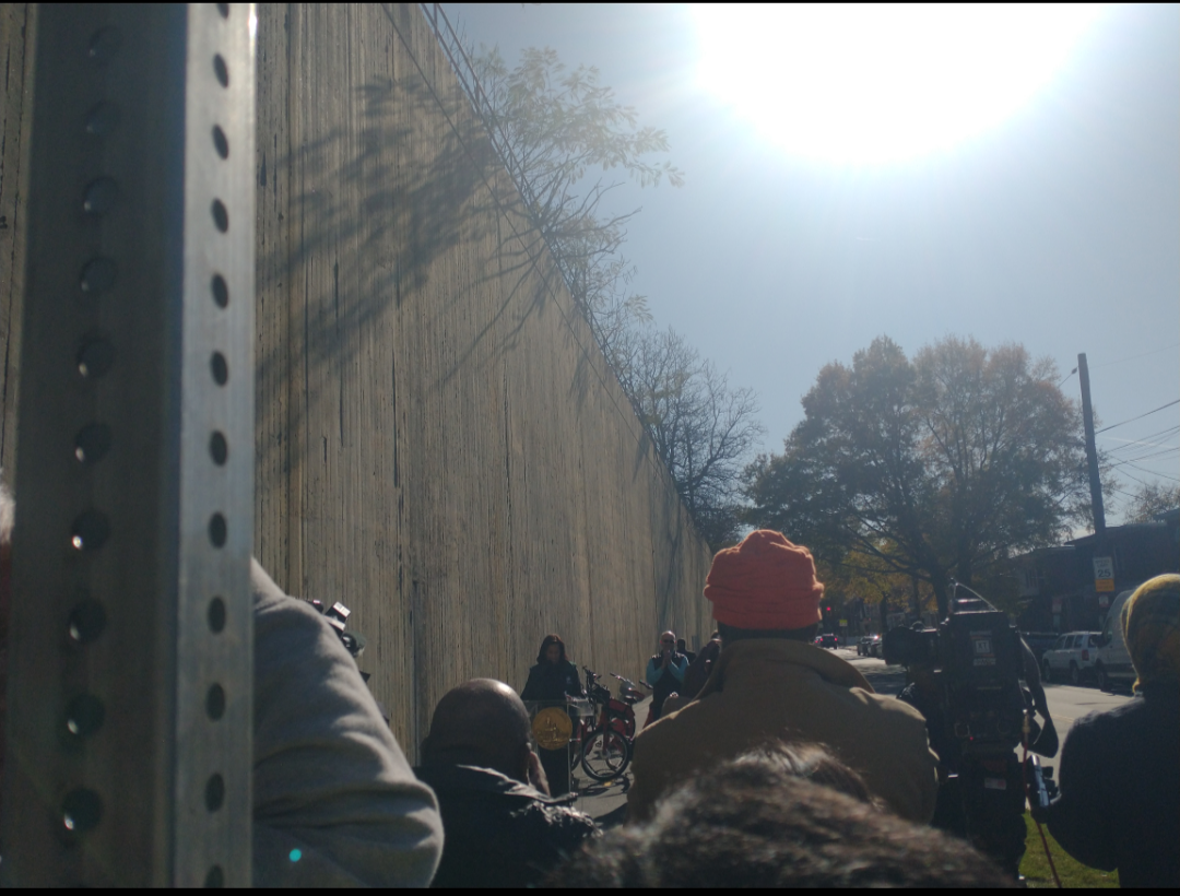
Mayor Muriel Bowser and DDOT Director Sharon Kershbaum officially opened the Fort Totten to Takoma segment of the Metropolitan Branch Trail (MBT) on November 12, 2025. Ward 4 Councilmember Janeese Lewis George, ANC Commissioner Charlie Mayer (4B04), and Washington Area Bicyclist Association Executive Director Elizabeth Kiker also gave remarks.
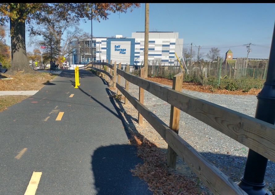
This section of the trail includes a short off-street section along Riggs Road NE before turning to an on-street portion along First Street NE, meandering through Manor Park before getting to Blair Road for an off-street portion. The section on Blair Road includes a lot of active curb cuts so it will be a bit of a different experience than the rest of the trail.
In her remarks, Director Kershbaum noted that DDOT has placed a couple of speed feedback devices on southern end of the trail to encourage reduced speeds to make the trail more comfortable for all users.
The next portion of the trail to be constructed will be the Piney Branch to Blair Road extension. This segment is still in the design phase as the agency had to negotiate easements with Metro and National Park Service. DDOT hopes to begin construction on this segment in 2026.
The District Department of Transportation (DDOT) invites residents to join a community meeting on Tuesday, November 18, 2025, from 6:30 pm to 8:00 pm on the Kansas Ave Protected Bike Lane Project. DDOT representatives will provide information about the project’s development, safety improvements, and construction timeline. Agency representatives will be available to hear your concerns and answer your questions. The meeting will be held at the Sela Public Charter School at 6015 Chillum Pl NE, Washington, DC 20011.
Kansas Ave NW Protected Bike Lane Community Meeting
Tuesday, November 18, 6:30 pm to 8:00 pm
Sela Public Charter School
6015 Chillum Pl NE Washington, DC 20011
Project Background
The Kansas Ave NW Protected Bike Lane is a multimodal safety project that includes the following features to improve safety for all roadway users:
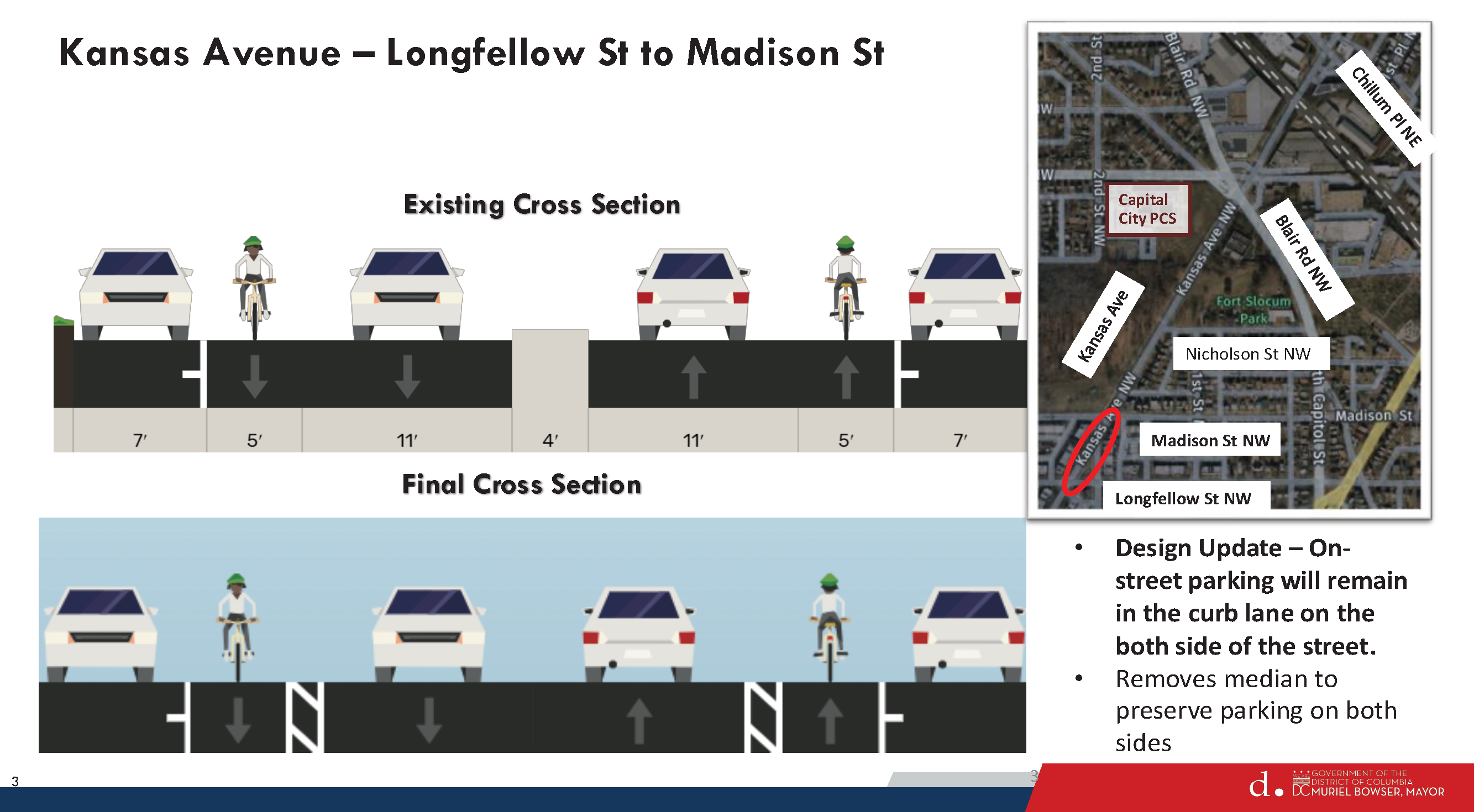
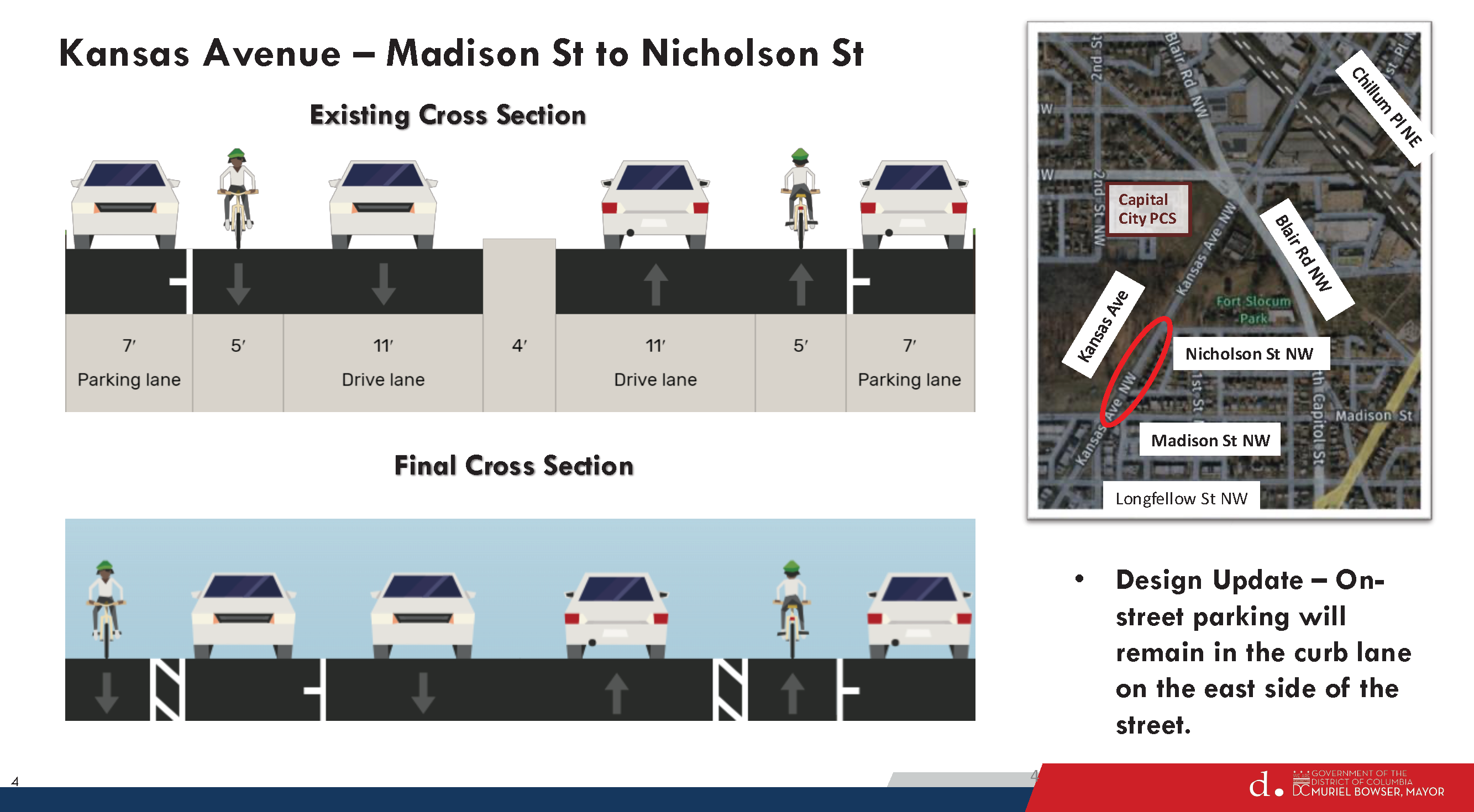
• Upgraded pedestrian crossings, including more visible Rapid Rectangular Flashing Beacons (RRFB) at Longfellow St NW and Madison St NW, and Nicholson St NW, following ADA guidelines. Intersection daylighting at Madison St NW to improve sightlines for drivers to see cross traffic.
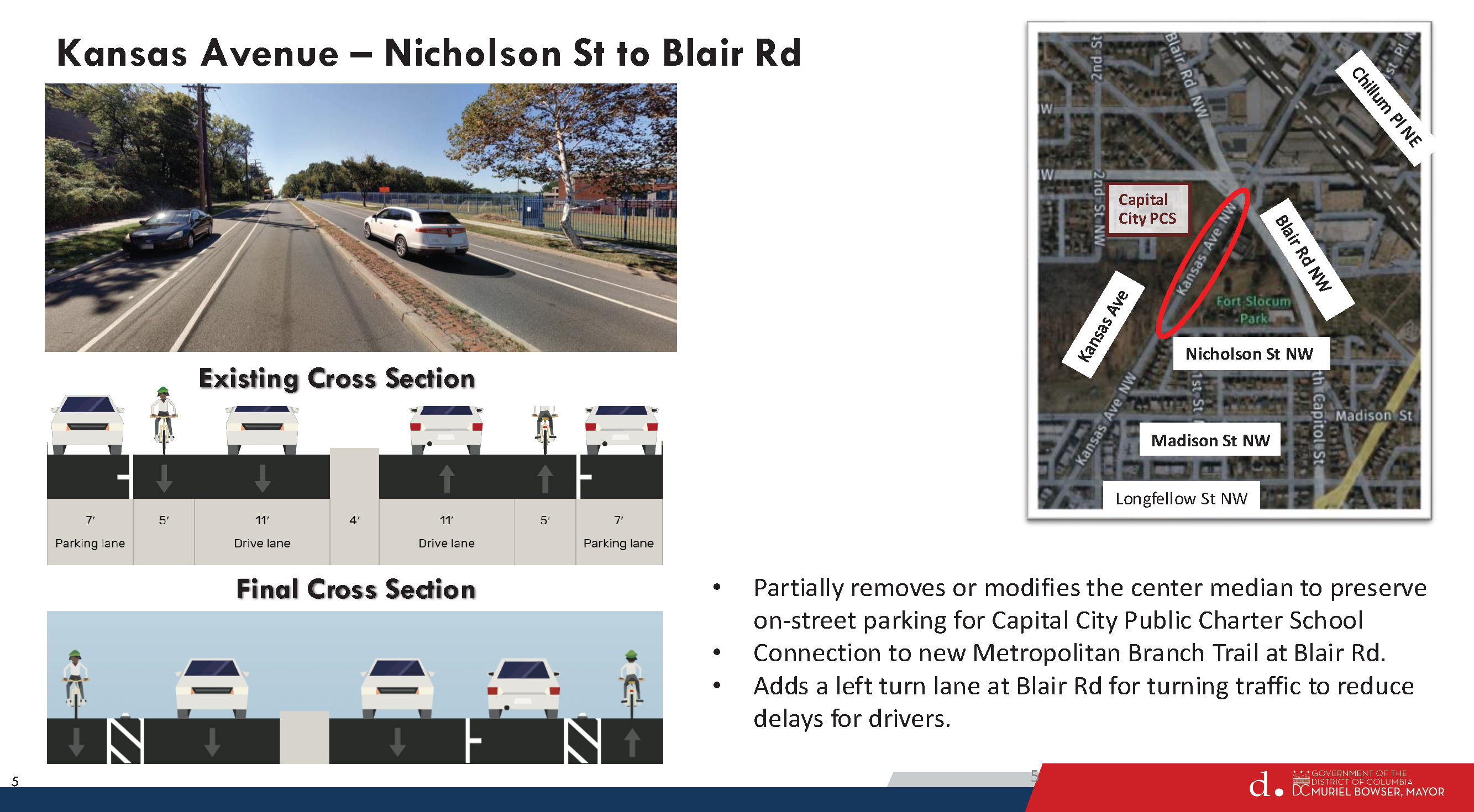
• Removal of center medians on the 5600 and 5700 blocks of Kansas Ave NW and a short section just south of Blair Rd to maintain on-street parking.
• Additional on-street parking along the west side of the 5600 block.
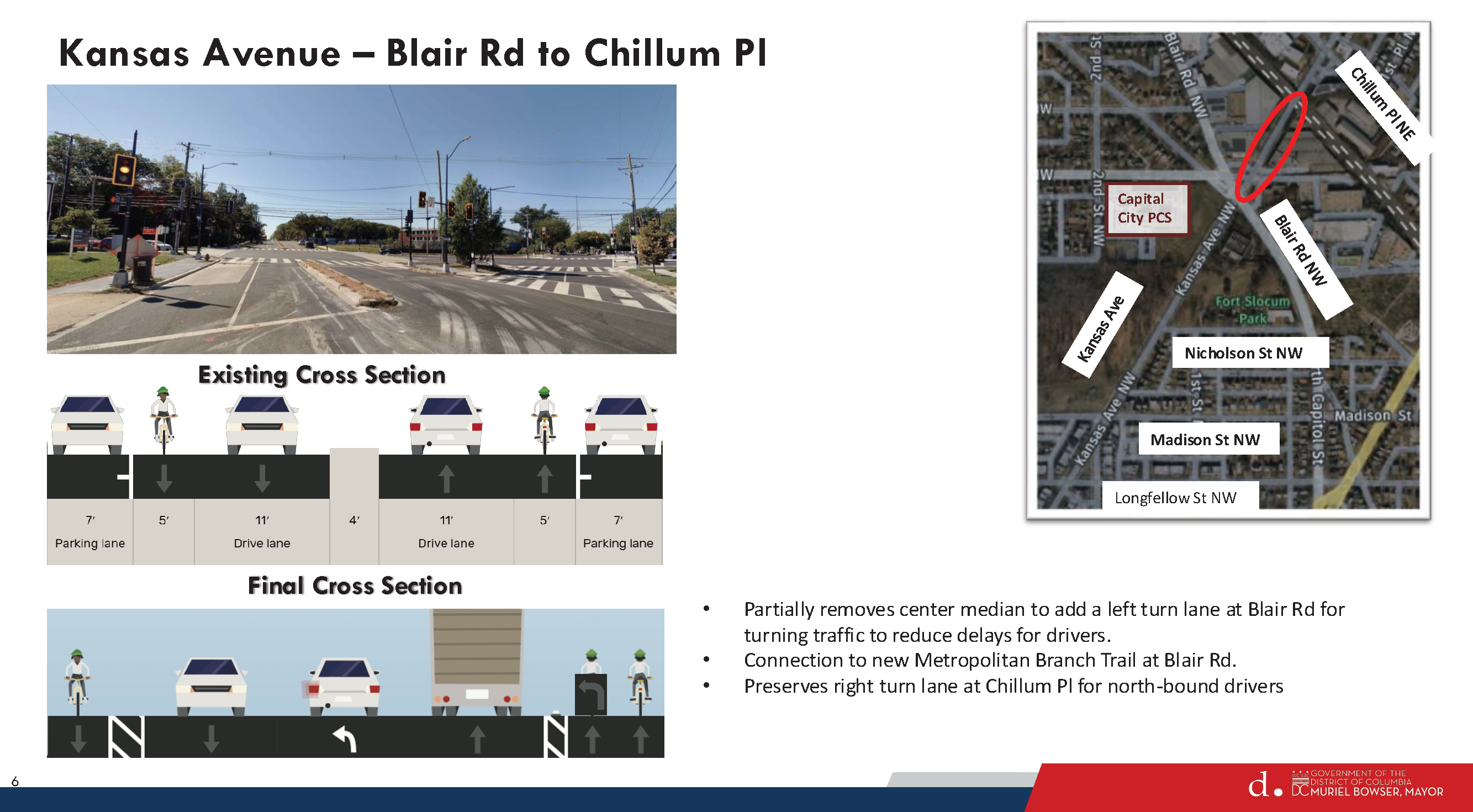
• New left turn lanes for southwest-bound and northeast-bound vehicular traffic at the intersection with Blair Rd to improve safety and traffic flow for drivers.
Closure of a critical gap in the bike lanes along the corridor between Chillum Place NE and Blair Rd NW to connect to the Metropolitan Branch Trail (MBT).
• Upgraded bike lanes between Blair Rd NW and Longfellow NW to protected bike lanes as a safety and traffic calming improvement.
When complete, the Kansas Ave NW Protected Bike Lane Project will create a safe and comfortable connection between the several schools in the neighborhood to the newly completed Metropolitan Branch Trail (MBT) extension.
The Fort Totten to Takoma extension of the MBT crosses Kansas Ave at Blair Rd and now provides a trail connection from the neighborhood 5.3 miles south to Union Station.
The cumulative effect of all of the improvements will be a safer street with fewer crashes and reduced speeding.
Please visit the project website for additional project details at: https://bikelanes.ddot.dc.gov/ pages/kansas-ave-nw. If you have any questions or concerns, please contact the DDOT Bikeways Branch Manager Greg Billing at gregory.billing@dc.gov or (202) 873-3756.
The District Department of Transportation (DDOT) invites you to a Ward 4 public workshop for the Strategic Bikeways Plan project. This in-person workshop will be held on Thursday, November 13 from 6p to 8p at the Raymond Recreation Center at 3725 10th Street NW. The project team will be presenting results from its evaluation of existing conditions and will be inviting community members and stakeholders to share feedback on the project team’s work to date, bicycle transportation needs, safety concerns, key gaps in the bicycle network, potential project ideas, and other local considerations.
Metrorail weekend service for Saturday, October 18 through Monday, October 19
Advisory Effective: 10/18/25 – 10/19/25
Hours: Sat 6 a.m. – 2 a.m.; Sun 6 a.m. – midnight
Red Line
Free shuttle buses replace trains between Union Station and Rhode Island Av. NoMa-Gallaudet Station closed. Trains run every 8 minutes (daytime) and 10 minutes (evening) between Shady Grove and Union Station and Normal Service frequencies between Rhode Island Av and Glenmont. At Judiciary Square only, one track will be closed to customers, and trains will arrive every 16 minutes (daytime) and 20 minutes after 9:30 p.m. on the track available to customers. As an alternative, customers can board nearby at Gallery Place-Chinatown for a shorter wait time.
Silver Line
Trains single track between Addison Road and Morgan Blvd. Trains run every 12 minutes (daytime) and 15 minutes (evening) between Ashburn and New Carrollton with no service on the Silver Line Downtown Largo branch.
The District Department of Transportation has issued a Notice of Intent (NOI) for proposed changes to 3rd and Kennedy Street NE (NOI-25-213-MSED). Submit comments to amha.kelemework@dc.gov by October 3, 2025.
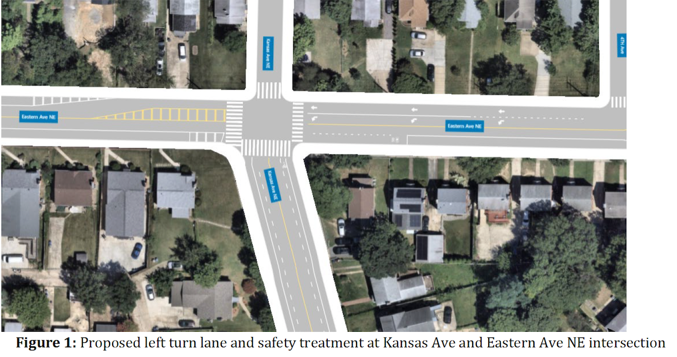
Copied from NOI
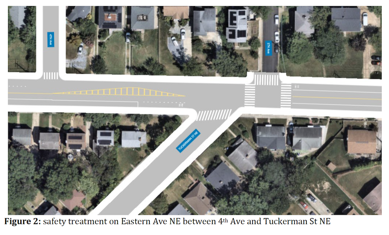
Left turn lane on Eastern Ave NE at Kansas Ave NE intersection
In response to a fatal crash that occurred in December 2024, DDOT is proposing safety treatments on Eastern Ave NE from Sligo Mill Road to Kansas Ave NE. DDOT is proposing the following changes:
A safe merging space for northbound Eastern Ave NE traffic after Sligo Mill Road intersection
Proposed left turn lane on Eastern Ave at Kansas Ave NE to provide a safe turning space and enhance traffic operation
Delineate bus stop/zone areas to reduce conflicts between bus and vehicular traffic
Rehabilitate existing damage to pavement on Eastern Ave NE between Kansas and 4th Ave.
The proposed safety treatments is intended to reduce crashes by providing a safer merging space for northbound eastern traffic after Sligo Mill Road, new markings will better guide vehicular traffic, and traffic operations should also improve by providing a dedicated left turn lane at Kansas Ave NE.
[Aside: Seems like DDOT is doing everything except completing the Rehabilitation of Eastern Avenue NE project that would address the issues on this road.]
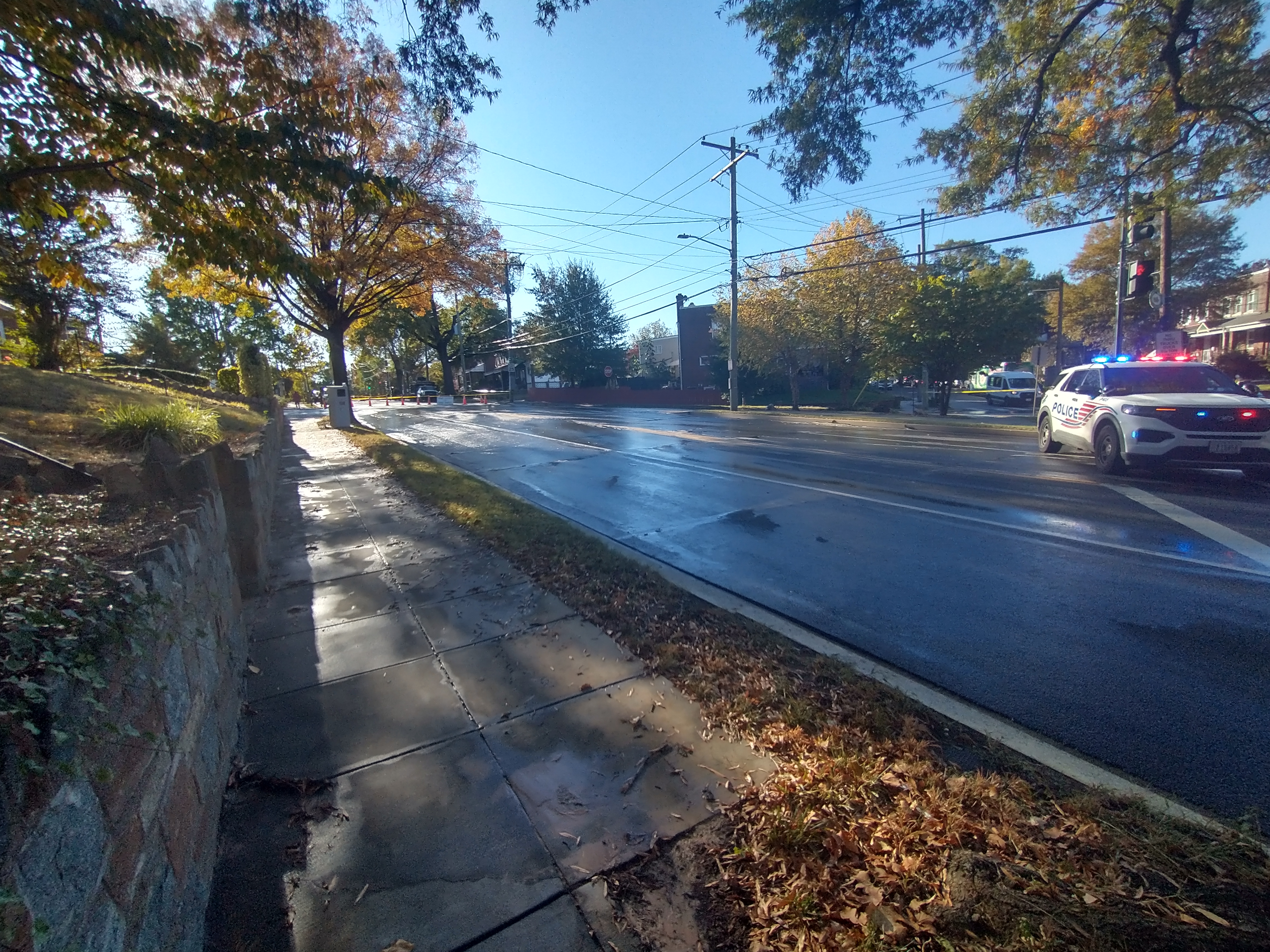
Below are pictures from the NOI, rearranged to show the driving pattern on Eastern from Sligo Mill to Kansas.
Neighbor Gavin passed along some trail and bike lane updates from the DC Bicycle Advisory Council. Learn more about active bike projects on DDOT’s Bike Lane Projects page.
Michigan Avenue Trail (between Harewood Road and Monroe Street): At 65% design – expect NOI to be published in September.
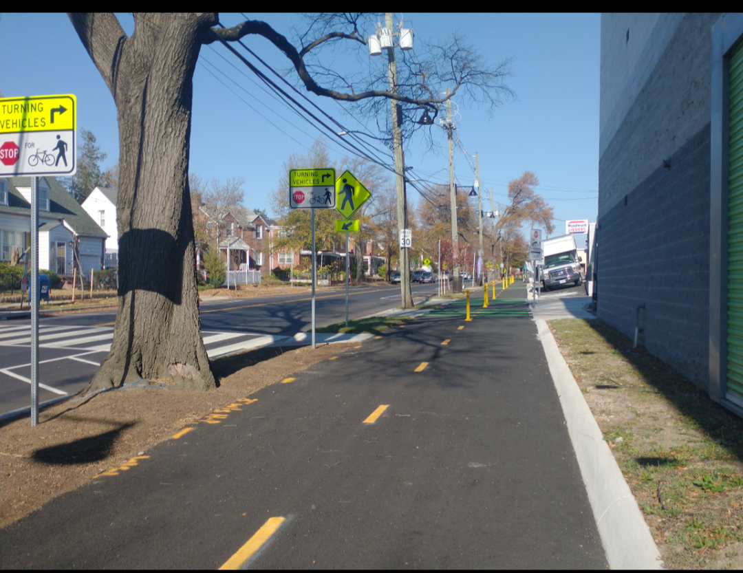
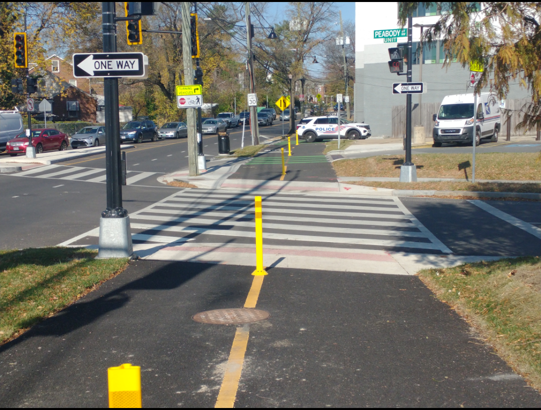
Galloway Street Trail: Eastern Federal Lands is finalizing 100% design and hopes to begin construction soon. Anticipated construction 2026/2027.
Kansas Avenue: Includes protected bike lanes between Blair Road NW and Chillum Place NE. The existing bike lanes between Longfellow and Blair Road will be upgraded to protected. Construction to begin in late September/early October.
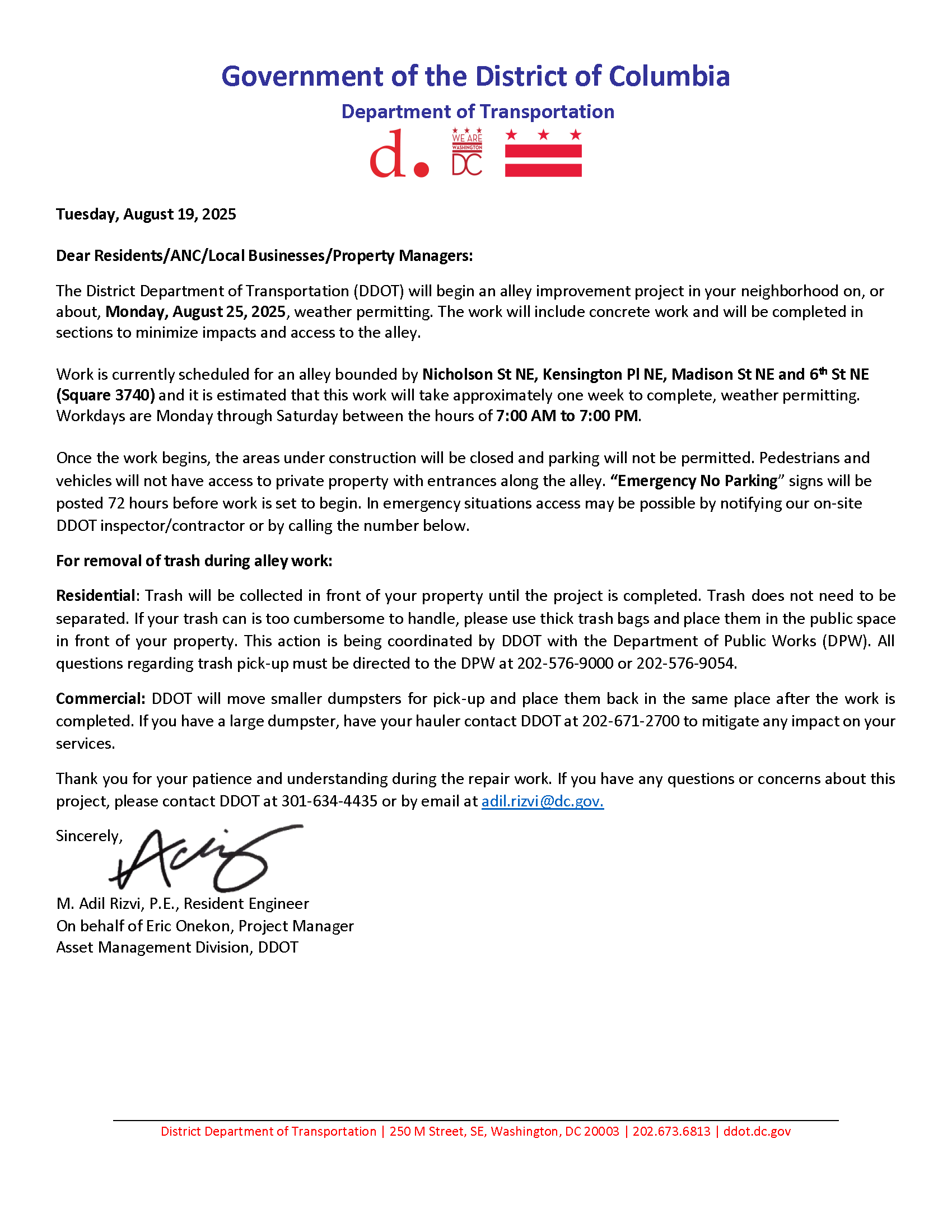
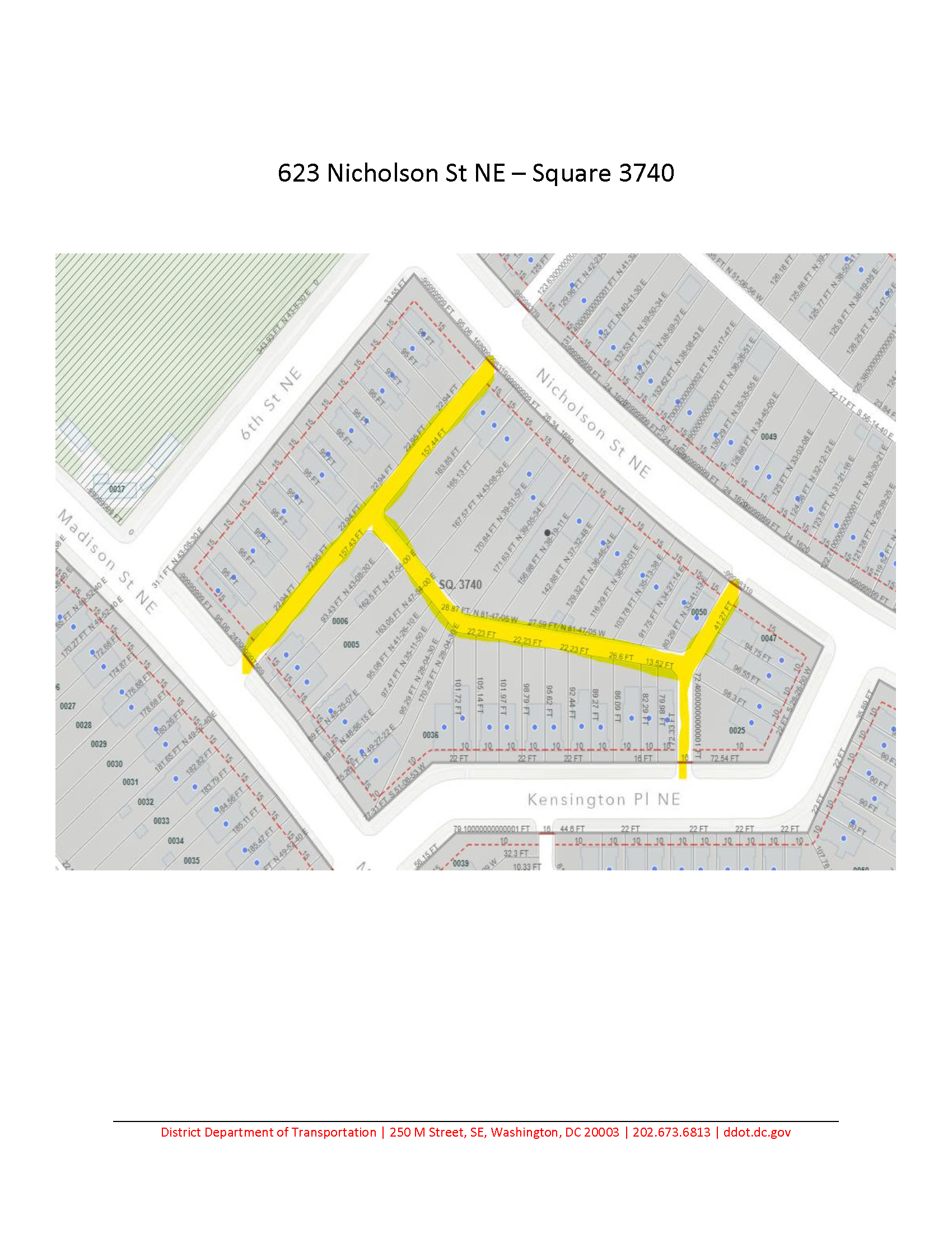
The District Department of Transportation (DDOT) will begin alley paving on Monday, August 25, 2025, weather permitting, for the alley bounded by Nicholson St NE, Kensington Pl NE, Madison St NE and 6th St NE (Square 3740). Work will take approximately one week to complete, weather permitting.
Workdays are Monday through Saturday between the hours of 7:00 AM to 7:00 PM. Once the work begins, the areas under construction will be closed and parking will not be permitted. Pedestrians and vehicles will not have access to private property with entrances along the alley.
For questions or concerns contact DDOT at 301-634-4435 or by email at adil.rizvi@dc.gov.
The District Department of Transportation (DDOT) held two public meetings to discuss next steps for the South Dakota Avenue NE Corridor Safety project.
The tl;dr is that DDOT will not be doing a road diet. Instead, they will focus on spot treatments at a few problematic intersections. DDOT has a new survey asking residents to rank possible locations for spot treatment. South Dakota & Galloway is one of the intersections being considered. South Dakota & Decatur is another.
For South Dakota & Galloway, they would potentially look at signal timing and improvements to crossings and cross time. For South Dakota & Decatur, they would potentially look at signalization, improvements to crossings, and simplifying the intersection.
If you care, take the survey and rank the locations. You can also suggest other locations for consideration.
It is worth taking at a look at the presentation slides and project website. DDOT explained how they determine whether a road diet is feasible. They explained the impact of a full road diet to travel the entire South Dakota Avenue corridor from Bladensburg to Riggs to show that delay would be minimal.
On weekdays, northbound motorists would see a 1 minute decrease in travel time for the entire corridor during morning peak and a 4.7 minute increase during evening peak.
On weekdays, southbound motorists would see a 7.3 minute increase in travel time for the entire corridor during morning peak and a 2.7 minute increase during evening peak.
On weekends, a full road diet would increase travel time 42 seconds going northbound and 2.3 minutes going southbound.
They also shared travel time impacts at key intersections. Spot treatment modeling videos are on the project website:
(One thing a resident pointed out to me is that these numbers are based on present day; the study does not take into account planned development along/near the corridor.)
A full road diet for the entire corridor would cost around $6.5 million. DDOT does not plan to seek funding necessary for a road diet, choosing to focus their efforts on the previously identified high risk corridors. DDOT will publish the safety study and keep it in DDOT’s library for future reference. They will use the $600,000 remaining in the project budget on spot treatments at a few locations.
Spot Treatments
Examples of safety treatments that may be implemented include:
New Traffic Signal Installation
Curb Extensions (Bulb-outs)
Pavement Marking Improvements
Turn Lane Modifications
No Turn on Red
Left-Turn Traffic Calming
Rectangular Rapid Flashing Beacons (RRFBs)
HAWK Signal (Pedestrian Hybrid Beacon)
Median Refuge Islands
DDOT discussed the costs of common treatments. A full traffic signal costs $300,000. Markings signs, and side street safety treatments can cost $10,000- $50,000 per intersection. Concrete improvements can start at $50k for a curb extensions or median island. So if DDOT puts a traffic signal at one of the intersections, that will use up half of the $600,000 budget for spot treatments. DDOT shared all of this to manage expectations and to emphasize that there will be tradeoffs depending on what is most important to residents.
As ranked by number of comments received, the number one and number two locations of concern were (1) South Dakota & Galloway and (2) South Dakota and Riggs. But DDOT does not plan to address South Dakota & Riggs any time soon. A DDOT representative first told me it is not part of Ward 5 (it partially is) and then they said that Riggs needs its own corridor study and that “we need to talk to our councilmember,” referring to the Ward 4 councilmember.
(Aside: This is pretty typical where the executive and council pass the ball back and forth and make residents jump through hoops again and again and do repeated backflips to get a known problem addressed. In this case, one that the city is responsible for poorly designing in the first place. Moving on.)
DDOT will select locations for spot treatment based on a few factors, including safety data and community input.
Selection criteria include:
High Injury Network intersections – areas with a history of severe or fatal crashes.
Intersections with high crash rates – based on recent traffic collision data.
School zones – especially where children frequently walk, bike, or cross busy streets.
Unsignalized multi-lane crosswalks – crossings that lack traffic signals and are challenging for people to navigate safely.
Resident-identified areas – any additional locations where the community has raised serious safety concerns.
During the meeting, DDOT stated they will prioritize locations based on crash data and turning movement (primarily looking at left turn conflicts with pedestrians). After the public presentation, DDOT told me they will also consider input from Councilmember Parker.
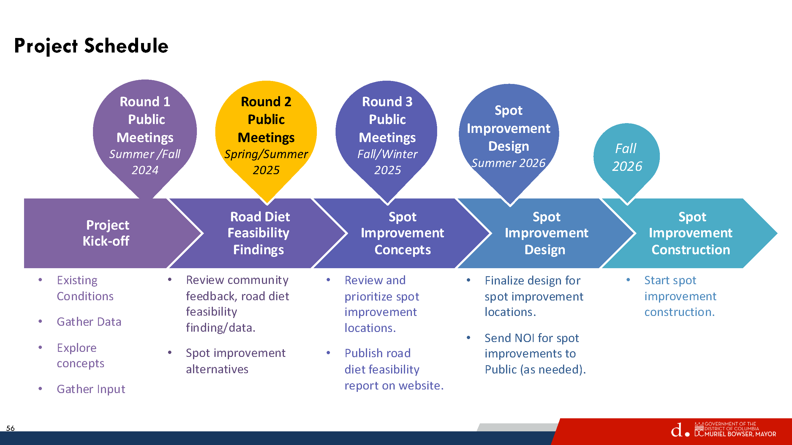
Timeline
DDOT will have a another meeting to review and prioritize spot improvement locations. Once the locations are selected, DDOT will finalize design and issue Notices of Intent (NOIs) before installing any treatment. DDOT expects to start spot improvement construction in fall 2026.
South Dakota Avenue Corridor Safety Project Public Meeting Notice
(WASHINGTON, DC) — The District Department of Transportation (DDOT), in partnership with Ward 5 Councilmember Zachary Parker, invites you to attend public meetings for the South Dakota Avenue Corridor Safety Project from Riggs Road NE to Bladensburg Road NE. DDOT will be hosting two meetings: a virtual meeting on Wednesday, July 9, 2025, and an in-person meeting on Saturday, July 12, 2025.
DDOT staff will provide an update on the progress of the study, present data and community feedback collected, and outline the next steps in the process. Attendees will have the opportunity to ask questions and engage directly with DDOT representatives.
Materials from this meeting will be made available on the study website within 72 hours of meeting conclusion. Those who would like to leave a comment about the study can do so by leaving a comment on the project website