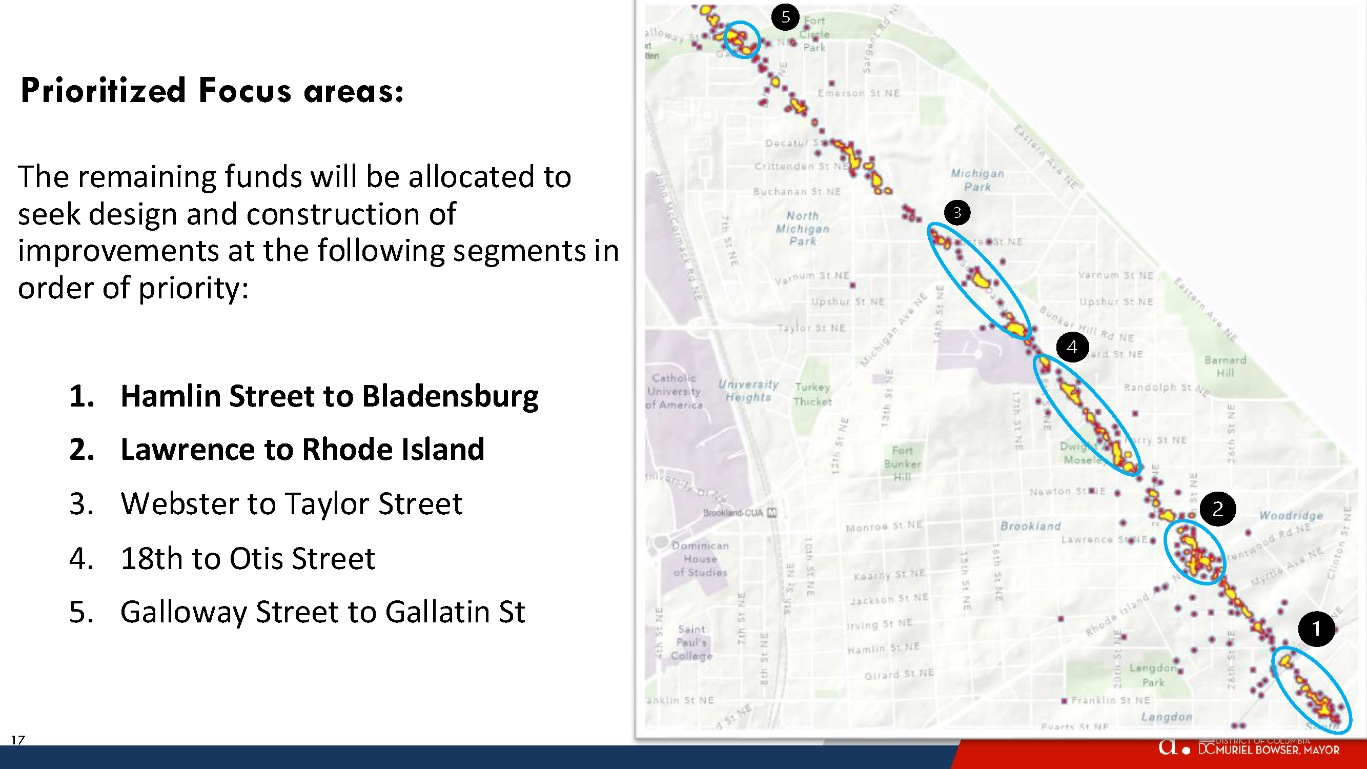
Spot Treatment Locations from Highest to Lowest priority
Hamlin Street to Bladensburg
Lawrence to Rhode Island
Webster to Taylor Street
18th to Otis Street
Galloway Street to Gallatin St
Galloway-Gallatin is the only location selected for spot treatment in this neck of the woods. DDOT did not plan to address anything on the northern end, but then Galloway received the most comments and Riggs Road received the second highest number of comments. So DDOT decided to put Galloway-Gallatin at the bottom of the priority list. Everyone, including DDOT, knows that Riggs is a problem but they say that addressing Riggs & South Dakota would be a very capital intensive project that would need support from the Ward 4 councilmember.
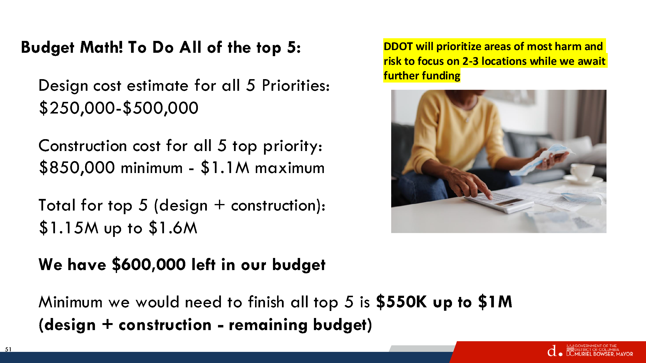
In any case, DDOT has about $600,000 remaining in the South Dakota Avenue corridor project budget, which is enough for just the top one or two priority areas. But Councilmember Zachary Parker’s office seems confident that they can get more money to do all five priority areas if residents really want them to.
So let’s pretend that DDOT will get to the northern end and take a look at what they propose for Galloway-Gallatin.
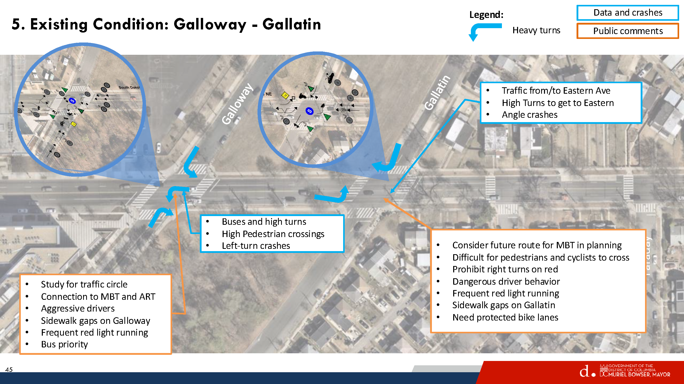
Existing Conditions Galloway-Gallatin
Residents are familiar with existing problems at South Dakota/Galloway and at South Dakota/Gallatin. Galloway gets a lot of traffic. It leads to the Fort Totten station and the Metropolitan Branch Trail, so lots of cars, buses, pedestrians, and people on bikes. The station is a major bus transfer point and lots of students use the station to get to nearby UDC and charter schools or to get on buses to go to schools outside the neighborhood. Gallatin sees less traffic than Galloway, but still gets a fair amount. And Gallatin is envisioned as a future connection to bike trails in Prince George’s County.
Looking at the existing conditions described by DDOT above, note that there is no intention of putting a traffic circle at either Galloway or Gallatin. That was a comment submitted by a resident during the early stages of the project.
Proposed Concept – Gallatin
For Gallatin, DDOT would consider a few things:
Centerline hardening southbound South Dakota to slow down turns
“Stop for Pedestrian while Turning” signs
Daylighting markings on all four corners of Gallatin to improve visibility of crossing pedestrians
Yellow frame around traffic lights so that they are easier to see
This all seems fine enough and would not interfere with potential bike facilities in the future.
Proposed Concept – Galloway
For Galloway Street, DDOT would consider doing a few things:
Northbound South Dakota Avenue
Dedicated left turn lane
Short Median in northbound travel lane would provide safe space for people in middle of crossing, ensure that drivers turn left at Galloway and do not proceed straight, and reduce the number of through lanes in just that one spot.
Center lane hardening
Southbound South Dakota Avenue
Lane markings
Eastbound Galloway Street
Two eastbound travel lanes so that there is a left turn lane for drivers to head northbound on South Dakota Avenue or proceed straight on Galloway and a dedicated right turn lane.
Westbound Galloway Street
One travel lane westbound
Daylighting markings east and west of South Dakota
This post is way too long so TL;DR here – I do not think what is proposed for Galloway makes sense, and I am curious what others think.
The thing that jumped out to me immediately is that the proposal states that DDOT would talk to Metro about removing the eastbound bus stop at Galloway & South Dakota in order to make two eastbound travel lanes on Galloway. I confirmed with DDOT that they were referring to the eastbound stop. In fact, Metro removed that eastbound bus stop during the bus network redesign but that got overlooked by DDOT.
That means the westbound stop on Galloway would remain. There are a lot of cars and buses that make that left turn onto Galloway. Currently, when buses make the turn onto Galloway and stop at that westbound stop (it is used a fair amount), cars are able to go around the bus. If DDOT makes two eastbound travel lanes and one westbound lane, I do not think there will be enough space for cars to go around the stopped bus and that would leave cars hanging out in the intersection trying to make the left turn. That would not be good.
DDOT said maybe they could move the stop further west or create a diversion space around the bus or something. I do not see where else the stop could go that would not create the same problem or become useless given that it is the last stop before the Metro station and moving it closer and closer to the station would eventually make it useless.
Also, I think I can safely say that the buses would not be able to make that turn onto Galloway if the stop bar is at the crosswalk. Moving the stop bar back could provide a better turning radius but then fewer vehicles would get through the intersection to turn left or go straight ahead.
With respect to the dedicated turn lanes westbound Galloway, I do not know that it makes sense to have vehicles traveling straight on Galloway sitting behind vehicles waiting to turn left.
I am also not sure about the treatment for South Dakota Avenue with the short refuge median there.
All of this to say, I am not so sure that the proposal for the Galloway-South Dakota travel lanes make a lot of sense. But I am not an engineer and I have not seen a traffic analysis, so I don’t know, maybe this all could make sense.
Things that I think would make sense:
More time for pedestrians to cross South Dakota at Galloway
Centerline hardening (though I suspect the buses will just run over it)
Daylighting on Galloway east of South Dakota on both sides of the street. Bulbouts here are actually included in UDC’s 2023-2033 Lamond-Riggs campus plan (which is not really moving forward because apparently there is no money or something). UDC’s enrollment at the Lamond-Riggs campus has grown tremendously (which is why they really need funding to proceed with their campus plan, so DC Council really should give them the money to do it!!). Between campus visitors and the youth sports teams that practice on the field across the street from the campus, lots of cars end up being parked right up to the intersection often enough.
I like the idea of dedicated left turn lanes because it is true that waiting for buses/cars to turn left backs up traffic and makes people impatient and they end up running the light regularly enough. But I just do not know that this concept is the way to do it unless maybe they removed the parking lane on Galloway west of South Dakota, which I am reluctant to even type out because I can just see heads exploding. Lots of parents drive to the daycare on Galloway so I can certainly see why people would want some curbside space to drop off and pick up the kiddos.
Also, a 10-foot multi-use path is supposed to be installed on the south side of Galloway between South Dakota and 4th Street, with construction currently anticipated in 2026-2027. This is one of those (federal) projects that keeps getting pushed back year after year for all sorts of reasons. If this does proceed as planned, it might be useful to see how travel patterns for pedestrians and people on bikes change.
None of this will likely do much to slow down the excessive speeding on South Dakota, which was supposed to be the whole point of the corridor project. But we abandoned that goal before we really got started so.
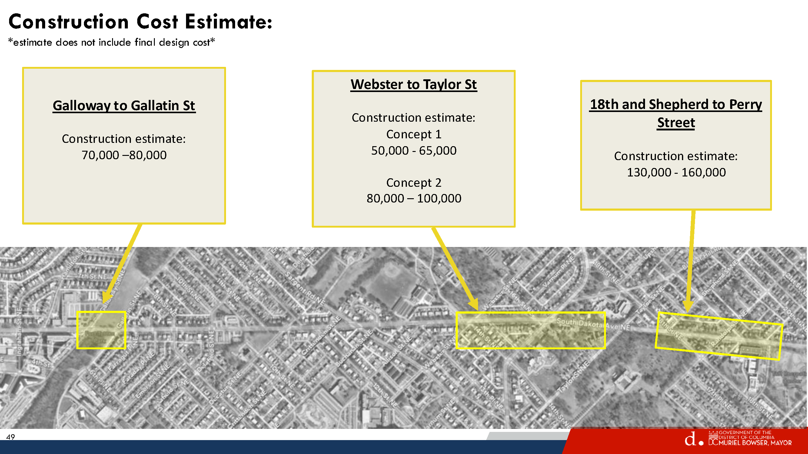
These are just my thoughts. DDOT will not do anything at Galloway-Gallatin unless residents really want them to and ask Councilmember Parker’s office to identify funding to get it done. The cost for Galloway-Gallatin is not that much (roughly $70,000-80,000), so people need to decide what they want to happen or not happen.
Thanks to neighbor Gavin for passing along information from DPR’s kickoff meeting for improvements to the playground at Lamond Rec, held on December 1, 2025.
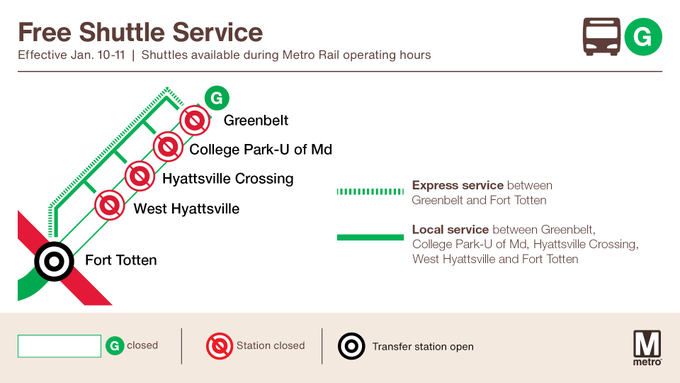
Metrorail weekend service for Saturday, January 10 through Sunday, January 11
Advisory Effective: 1/10/26 – 1/11/26
Hours: Sat 6 a.m. – 2 a.m.; Sun 6 a.m. – midnight
Green Line
Free shuttle buses replace trains between Fort Totten and Greenbelt stations. West Hyattsville, Hyattsville Crossing, College Park U-MD, and Greenbelt stations closed. Trains run every 8 minutes.
Yellow Line
Modifed service: Trains run every 8 minutes between Huntington and Mt Vernon Sq.
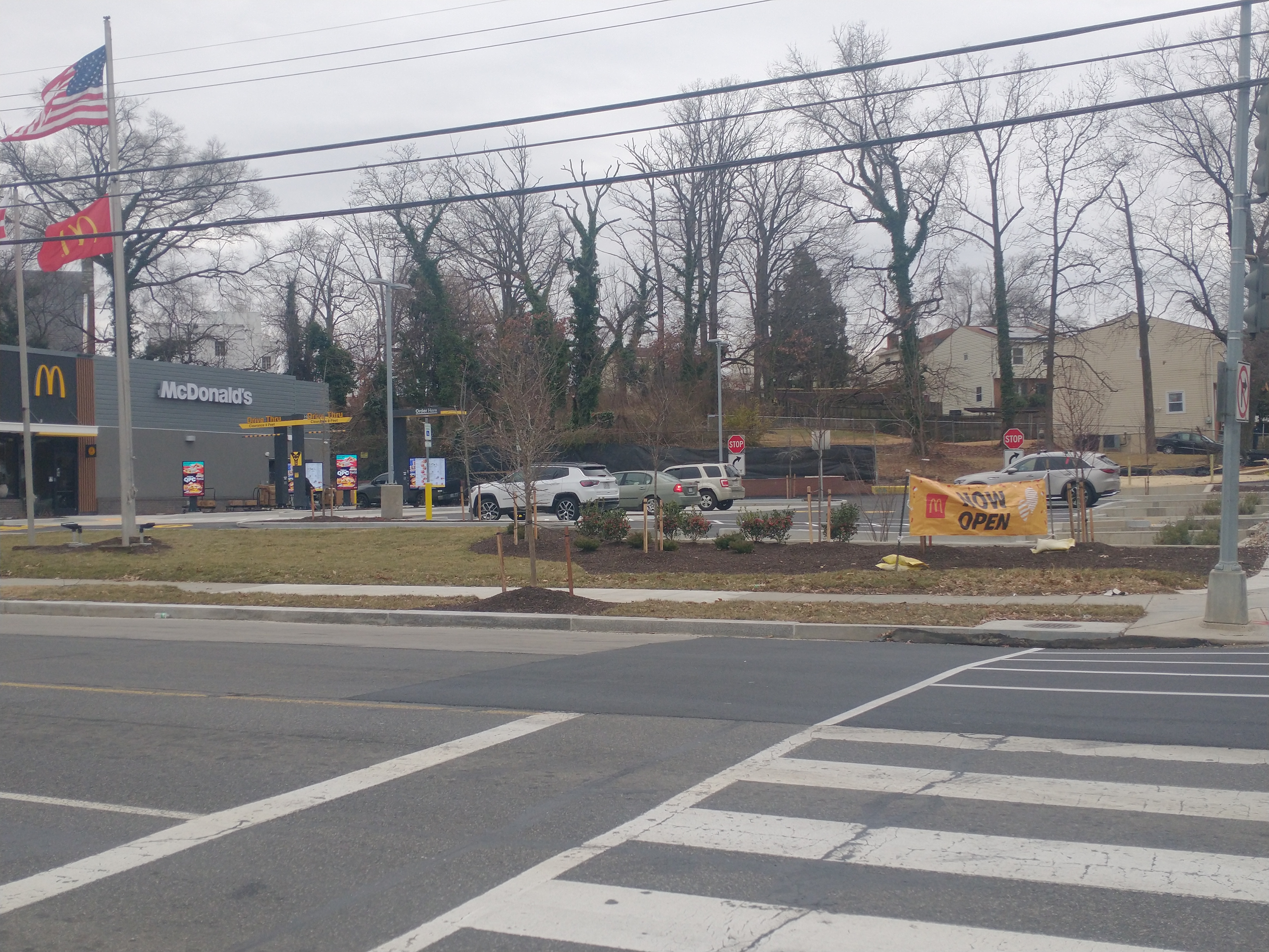
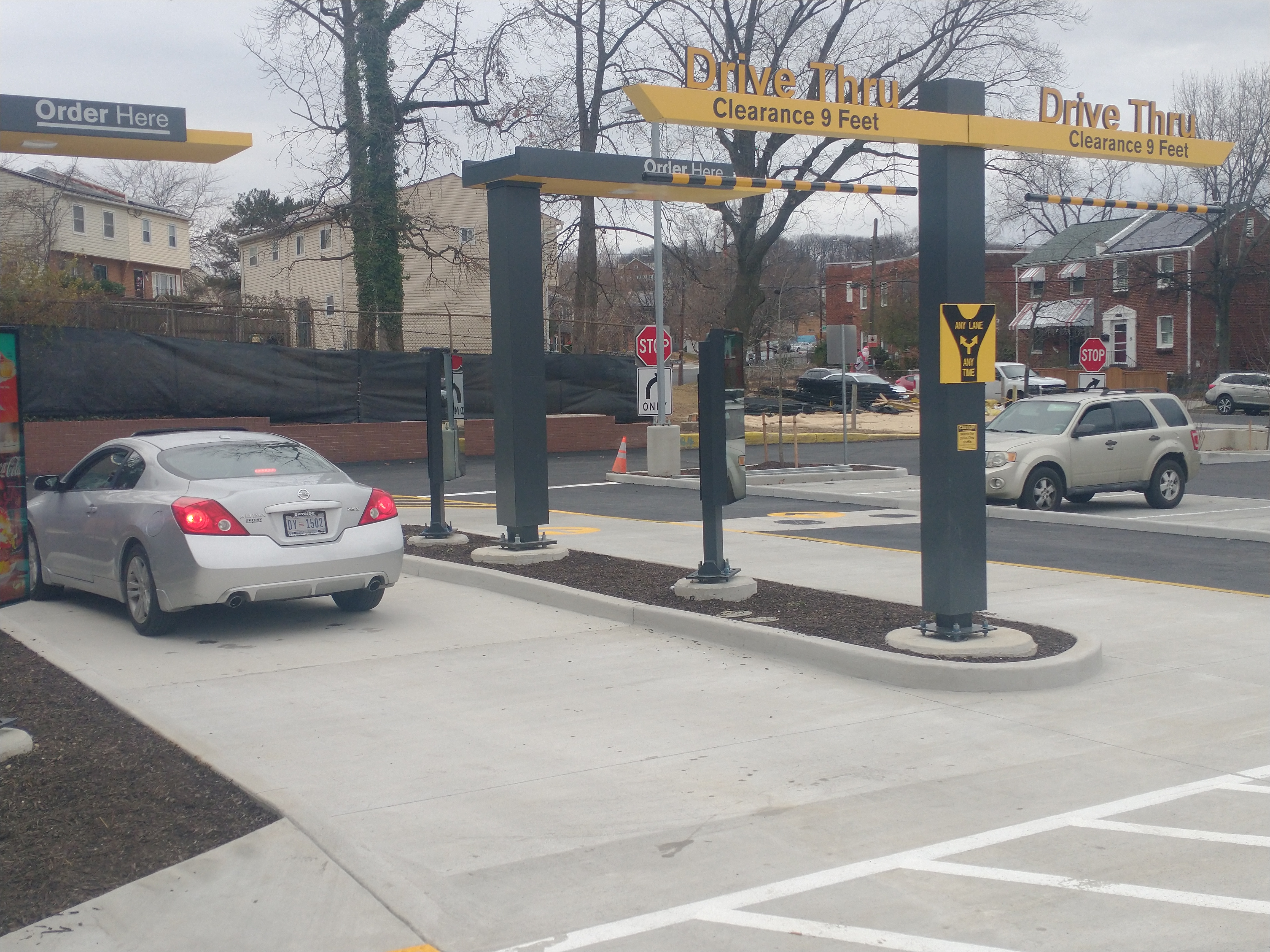
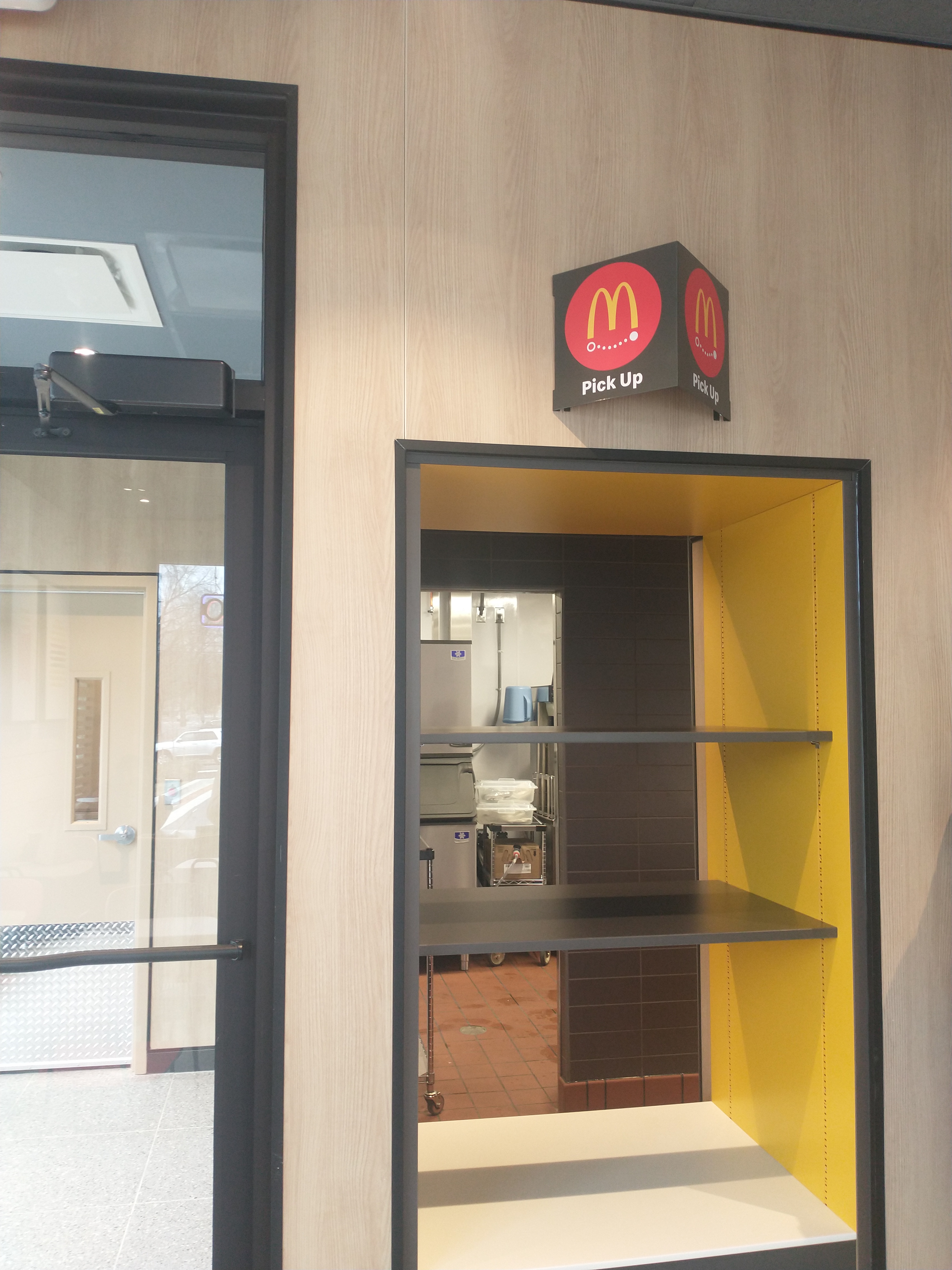
The new restaurant features dual drive-thru lanes; indoor and outdoor pick-up windows for mobile ordering; a few parking spaces; and extensive planting beds. The rebuilt restaurant replaces what some called the first McDonald’s in the city. With the help of the DC Office of Planning, former Ward 5 Councilmember Harry Thomas, Jr., and the North Michigan Park Civic Association (under leadership of former president Grace Lewis who moved out of the city in 2023), McDonald’s utilized a chaotic Comp Plan process to upzone the property for the sole purpose of tearing down the old restaurant that did not have a drive-thru in order to build a new one with a drive-thru as a matter of right.
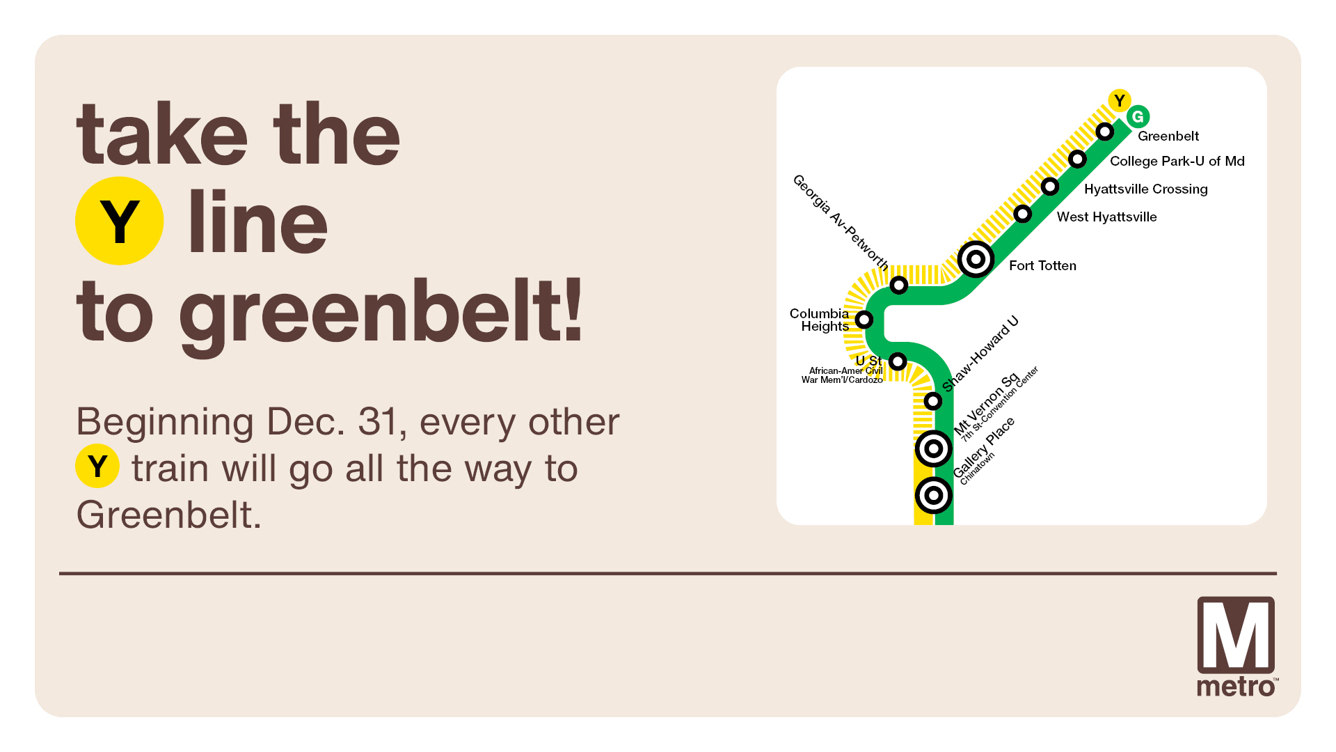
Beginning December 31, 2025, half of Yellow Line trains will operate between Huntington and Greenbelt (every 12-15 mins) and the other half will operate between Huntington & Mt. Vernon Sq (every 6-8 mins).
Thanks to neighbor Gavin for passing along information from DPR’s kickoff meeting for improvements to the playground at Lamond Rec, held on December 1, 2025.
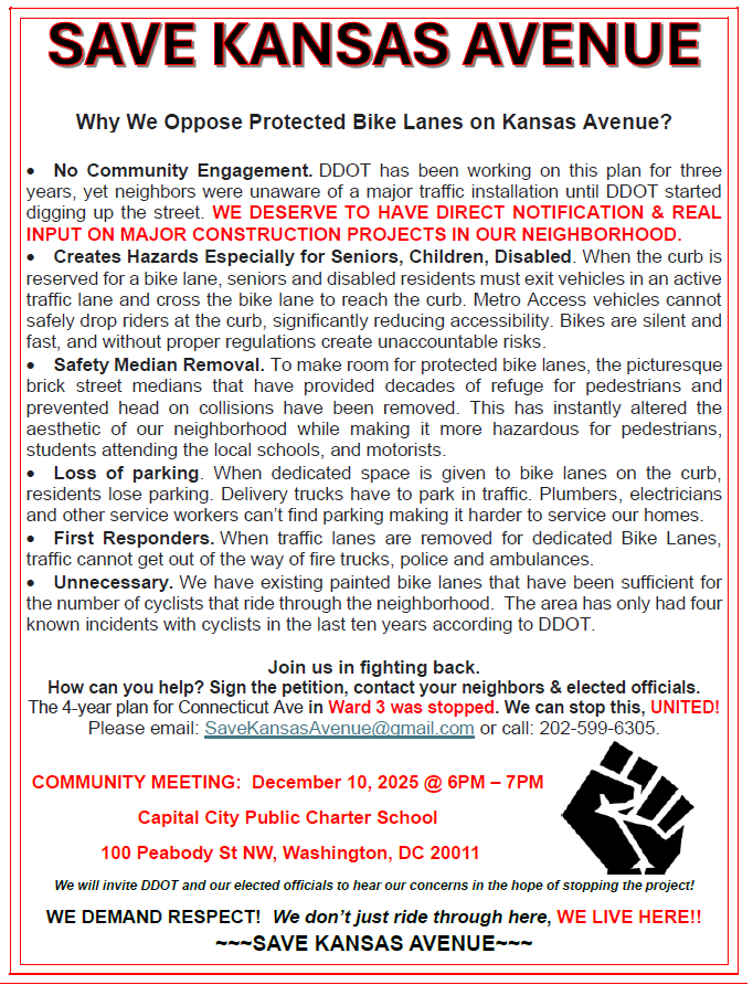
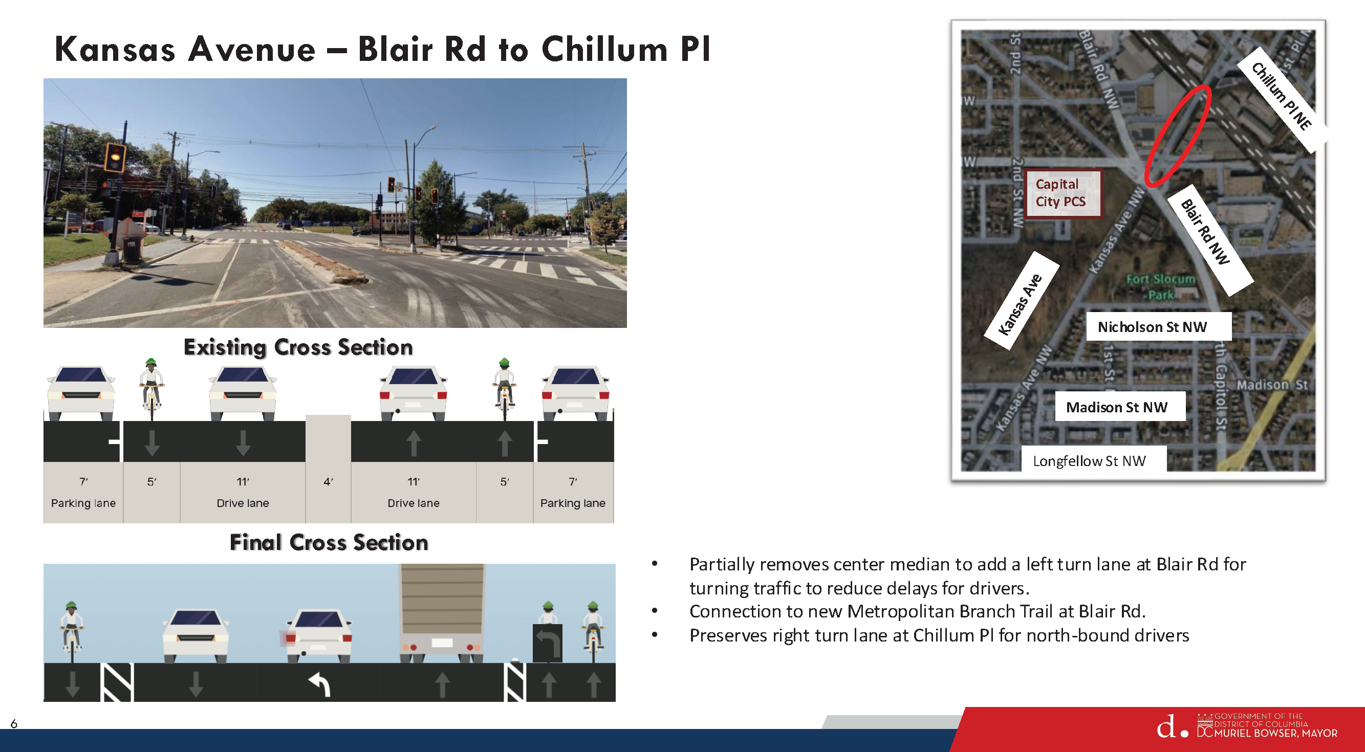
A couple of days ago, I received an email from a group calling itself “Save Kansas Avenue.” They sent this email in response to last week’s post about the updated design for the Kansas Avenue bike lane project. They said they wanted to share information from the perspective of some of the directly impacted residents, and they passed along the flyer created for the community meeting organized on December 10. Primarily they say that DDOT did not do sufficient community engagement over the life of this project and that many residents were not aware of this project until after construction began a few weeks ago.
(I published a post about the Notice of Intent for this project back in 2022. The NOI is the point when the public weighs in. I do not know what kind of outreach was done at that point and over the years to let people know about this project. I also published a post in September of this year with an update about the construction timeline that was slated for October. Again, I do not know what kind of outreach was done at that point to convey the construction timeline. The email from the Save Kansas Avenue group stated that over the past three years, DDOT has engaged only with ANC commissioners and the charter schools in the area (and they say that the charter schools are opposed to the protected bike lanes) and that residents did not get any notice about construction before it started.)
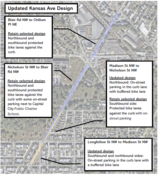
On December 5, DDOT provided detailed responses to resident concerns in a letter (linked in last week’s blog post) explaining what design changes the agency planned to make. Residents organized a community meeting on December 10 where DDOT gave a presentation about the updated design. I did not attend that meeting. The presentation is available on the Kansas Avenue bike lane project website.
Updated Kansas Avenue bike lane design, December 10, 2025.
The Save Kansas Avenue group wanted to let me know that even with DDOT’s updated design they are still against the project. They wrote:
[T]he community is still against it because of the hazardous conditions it has caused with the removal of the street medians to accommodate the bike lanes. Additionally, we see a great opportunity with the city by instead of installing protected bike lanes, the city could install a multi use trail at the Fort Slocum Park by expanding the sidewalk by 4 feet. This would not only accommodate pedestrians and cyclists, but also tie it to the adjacent Metro Branch Trail and would be better for the local community.
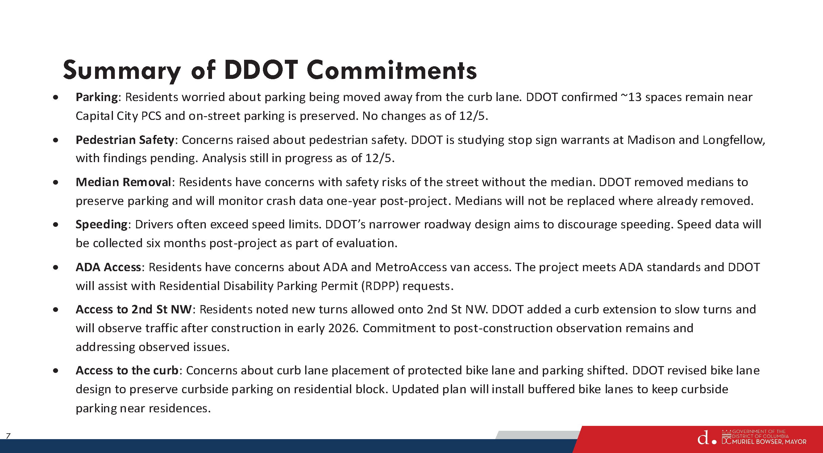
Summary of DDOT’s commitments from December 10, 2025, presentation.
Included in the December 10th presentation is a slide about DDOT’s commitments going forward. Unclear what will ultimately happen given the continued concerns from these residents.
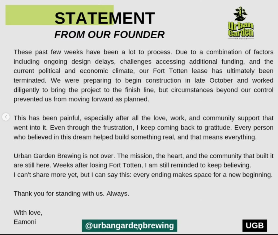
Urban Garden Brewing is no longer coming to Art Place at Fort Totten. The brewery was looking at locating in the first phase of Art Place on South Dakota Avenue. Owner Eamoni Collier posted a message on instagram a couple of days ago:
These past few weeks have been a lot to process. Due to a combination of factors including ongoing design delays, challenges accessing additional funding, and the current political and economic climate, our Fort Totten lease has ultimately been terminated. We were preparing to begin construction in late October and worked diligently to bring the project to the finish line, but circumstances beyond our control prevented us from moving forward as planned.
This has been painful, especially after all the love, work, and community support that went into it. Even through the frustration, I keep coming back to gratitude. Every person who believed in this dream helped build something real, and that means everything.
Urban Garden Brewing is not over. The mission, the heart, and the community that built it are still here. Weeks after losing Fort Totten, I am still reminded to keep believing.
I can’t share more yet, but I can say this: every ending makes space for a new beginning.
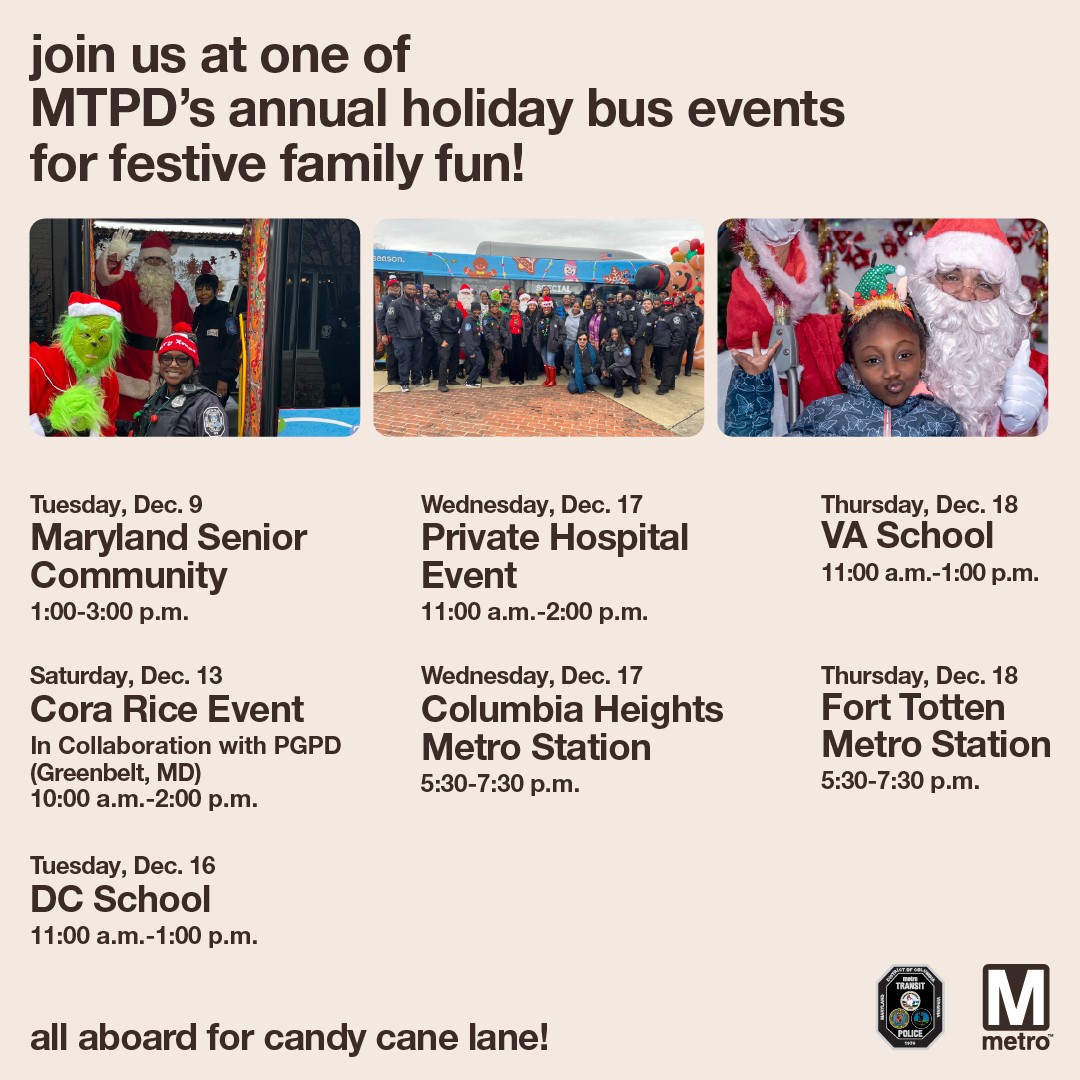
Join Metro Transit Police Department for their annual Holiday Bus event at Fort Totten Metro station on December 18, 2025, 5:30 pm-7:30 pm. Enjoy festive bus decorations, music, and holiday treats.
DC Dental Studio, a general dentist practice by Dr. Jasmine Marshall, is now open at Art Place at Fort Totten, located at 430 Galloway Street NE, Suite B.
Construction on the Green Line will cause single-tracking between U St and Georgia Av-Petworth starting at 10 p.m. on Tuesday, Dec. 16 through system closing Tuesday, Dec. 30.
Customers are encouraged to plan ahead and allow additional travel time.
All stations will remain open. However, wait times will be longer than usual with Green Line trains running every 16 minutes all day. Yellow Line trains will run every 8 minutes all day between Mt. Vernon Square and Huntington during the construction period.
Customers also have several bus options as alternatives, including the D40 and D4X along Georgia Avenue NW, the D50 and D5X along 14th Street NW, the D60 and D6X along 16th Street NW, the C51 and C53 along U Street NW, and the C61 along Columbia Road/Irving Street NW.
Metro is doing critical work to improve safety and reliability, including replacing rail and fastening systems, renewing communications and signal equipment, and restoring lighting infrastructure. For more information, visit the winter major construction page.
Metro scheduled this work during the holiday season, when ridership is typically lower, to minimize impacts on customers.
Starting Dec. 31: Yellow Line to Greenbelt
Once construction ends, the Yellow Line extension to Greenbelt will begin on Dec. 31. Half of the Yellow Line trains will operate between Huntington and Greenbelt, and the other half will operate between Huntington and Mt. Vernon Square.
Trip Planning Resources
Customers are encouraged to use MetroPulse or wmata.com for real-time service information, sign up for MetroAlerts, or check @wmata, @metrorailinfo, and @metrobusinfo on social media for updates. Customers can also call 202-GO-METRO (202-466-3876, TTY 202-962-2033), M-F, 7 am-8 pm; Sat-Sun, 8 am-8 pm. Automated information is available 24/7. View our planned track work at wmata.com/trackwork.
Spot Treatment Locations from Highest to Lowest priority
Hamlin Street to Bladensburg
Lawrence to Rhode Island
Webster to Taylor Street
18th to Otis Street
Galloway Street to Gallatin St
Galloway-Gallatin is the only location selected for spot treatment in this neck of the woods. DDOT did not plan to address anything on the northern end, but then Galloway received the most comments and Riggs Road received the second highest number of comments. So DDOT decided to put Galloway-Gallatin at the bottom of the priority list. Everyone, including DDOT, knows that Riggs is a problem but they say that addressing Riggs & South Dakota would be a very capital intensive project that would need support from the Ward 4 councilmember.
In any case, DDOT has about $600,000 remaining in the South Dakota Avenue corridor project budget, which is enough for just the top one or two priority areas. But Councilmember Zachary Parker’s office seems confident that they can get more money to do all five priority areas if residents really want them to.
So let’s pretend that DDOT will get to the northern end and take a look at what they propose for Galloway-Gallatin.
Existing Conditions Galloway-Gallatin
Residents are familiar with existing problems at South Dakota/Galloway and at South Dakota/Gallatin. Galloway gets a lot of traffic. It leads to the Fort Totten station and the Metropolitan Branch Trail, so lots of cars, buses, pedestrians, and people on bikes. The station is a major bus transfer point and lots of students use the station to get to nearby UDC and charter schools or to get on buses to go to schools outside the neighborhood. Gallatin sees less traffic than Galloway, but still gets a fair amount. And Gallatin is envisioned as a future connection to bike trails in Prince George’s County.
Looking at the existing conditions described by DDOT above, note that there is no intention of putting a traffic circle at either Galloway or Gallatin. That was a comment submitted by a resident during the early stages of the project.
Proposed Concept – Gallatin
For Gallatin, DDOT would consider a few things:
Centerline hardening southbound South Dakota to slow down turns
“Stop for Pedestrian while Turning” signs
Daylighting markings on all four corners of Gallatin to improve visibility of crossing pedestrians
Yellow frame around traffic lights so that they are easier to see
This all seems fine enough and would not interfere with potential bike facilities in the future.
Proposed Concept – Galloway
For Galloway Street, DDOT would consider doing a few things:
Northbound South Dakota Avenue
Dedicated left turn lane
Short Median in northbound travel lane would provide safe space for people in middle of crossing, ensure that drivers turn left at Galloway and do not proceed straight, and reduce the number of through lanes in just that one spot.
Center lane hardening
Southbound South Dakota Avenue
Lane markings
Eastbound Galloway Street
Two eastbound travel lanes so that there is a left turn lane for drivers to head northbound on South Dakota Avenue or proceed straight on Galloway and a dedicated right turn lane.
Westbound Galloway Street
One travel lane westbound
Daylighting markings east and west of South Dakota
This post is way too long so TL;DR here – I do not think what is proposed for Galloway makes sense, and I am curious what others think.
The thing that jumped out to me immediately is that the proposal states that DDOT would talk to Metro about removing the eastbound bus stop at Galloway & South Dakota in order to make two eastbound travel lanes on Galloway. I confirmed with DDOT that they were referring to the eastbound stop. In fact, Metro removed that eastbound bus stop during the bus network redesign but that got overlooked by DDOT.
That means the westbound stop on Galloway would remain. There are a lot of cars and buses that make that left turn onto Galloway. Currently, when buses make the turn onto Galloway and stop at that westbound stop (it is used a fair amount), cars are able to go around the bus. If DDOT makes two eastbound travel lanes and one westbound lane, I do not think there will be enough space for cars to go around the stopped bus and that would leave cars hanging out in the intersection trying to make the left turn. That would not be good.
DDOT said maybe they could move the stop further west or create a diversion space around the bus or something. I do not see where else the stop could go that would not create the same problem or become useless given that it is the last stop before the Metro station and moving it closer and closer to the station would eventually make it useless.
Also, I think I can safely say that the buses would not be able to make that turn onto Galloway if the stop bar is at the crosswalk. Moving the stop bar back could provide a better turning radius but then fewer vehicles would get through the intersection to turn left or go straight ahead.
With respect to the dedicated turn lanes westbound Galloway, I do not know that it makes sense to have vehicles traveling straight on Galloway sitting behind vehicles waiting to turn left.
I am also not sure about the treatment for South Dakota Avenue with the short refuge median there.
All of this to say, I am not so sure that the proposal for the Galloway-South Dakota travel lanes make a lot of sense. But I am not an engineer and I have not seen a traffic analysis, so I don’t know, maybe this all could make sense.
Things that I think would make sense:
More time for pedestrians to cross South Dakota at Galloway
Centerline hardening (though I suspect the buses will just run over it)
Daylighting on Galloway east of South Dakota on both sides of the street. Bulbouts here are actually included in UDC’s 2023-2033 Lamond-Riggs campus plan (which is not really moving forward because apparently there is no money or something). UDC’s enrollment at the Lamond-Riggs campus has grown tremendously (which is why they really need funding to proceed with their campus plan, so DC Council really should give them the money to do it!!). Between campus visitors and the youth sports teams that practice on the field across the street from the campus, lots of cars end up being parked right up to the intersection often enough.
I like the idea of dedicated left turn lanes because it is true that waiting for buses/cars to turn left backs up traffic and makes people impatient and they end up running the light regularly enough. But I just do not know that this concept is the way to do it unless maybe they removed the parking lane on Galloway west of South Dakota, which I am reluctant to even type out because I can just see heads exploding. Lots of parents drive to the daycare on Galloway so I can certainly see why people would want some curbside space to drop off and pick up the kiddos.
Also, a 10-foot multi-use path is supposed to be installed on the south side of Galloway between South Dakota and 4th Street, with construction currently anticipated in 2026-2027. This is one of those (federal) projects that keeps getting pushed back year after year for all sorts of reasons. If this does proceed as planned, it might be useful to see how travel patterns for pedestrians and people on bikes change.
None of this will likely do much to slow down the excessive speeding on South Dakota, which was supposed to be the whole point of the corridor project. But we abandoned that goal before we really got started so.
These are just my thoughts. DDOT will not do anything at Galloway-Gallatin unless residents really want them to and ask Councilmember Parker’s office to identify funding to get it done. The cost for Galloway-Gallatin is not that much (roughly $70,000-80,000), so people need to decide what they want to happen or not happen.
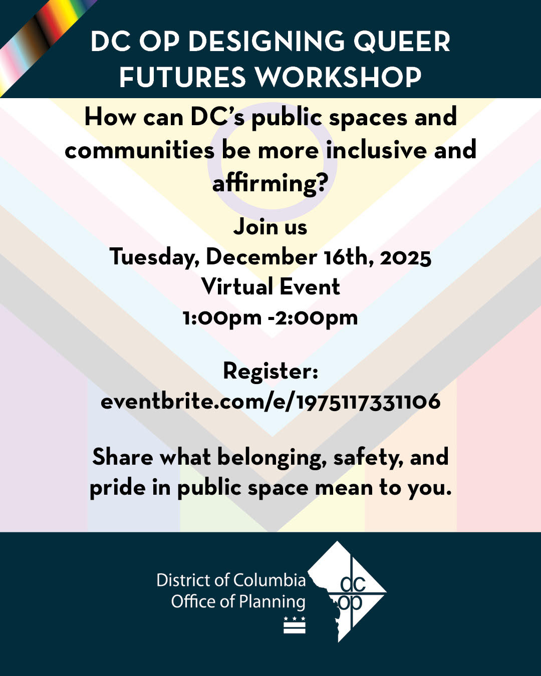
The DC Office of Planning (OP) is working on DC 2050, the update to DC’s Comprehensive Plan, that will guide how the city will grow. So far, OP has hosted several in-person public workshops. Now there is an online self-guided version of the public workshops that gives residents an opportunity to explore the city’s land use policy and let District officials know how and where you think the city should grow.
OP is hosting an online workshop next Tuesday December 16, 2025, entitled “Designing Queer Futures Workshop.” The DC Office of Planning invites LGBTQIA+ community members, elders, advocates, and allies to share with OP what matters to them.
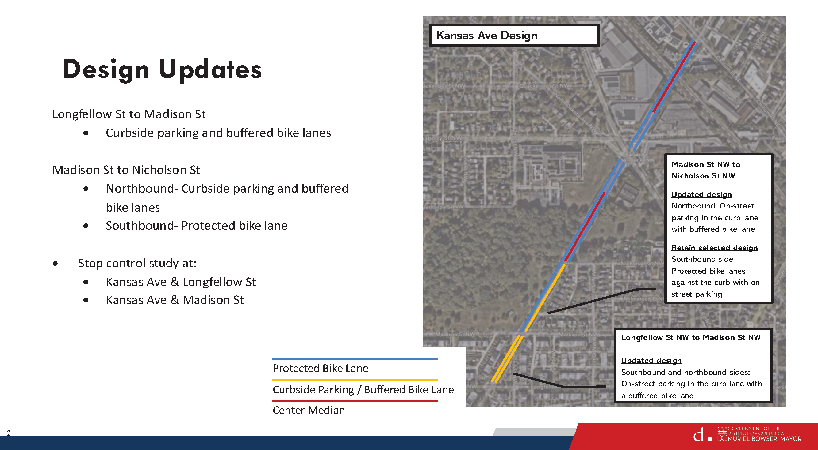
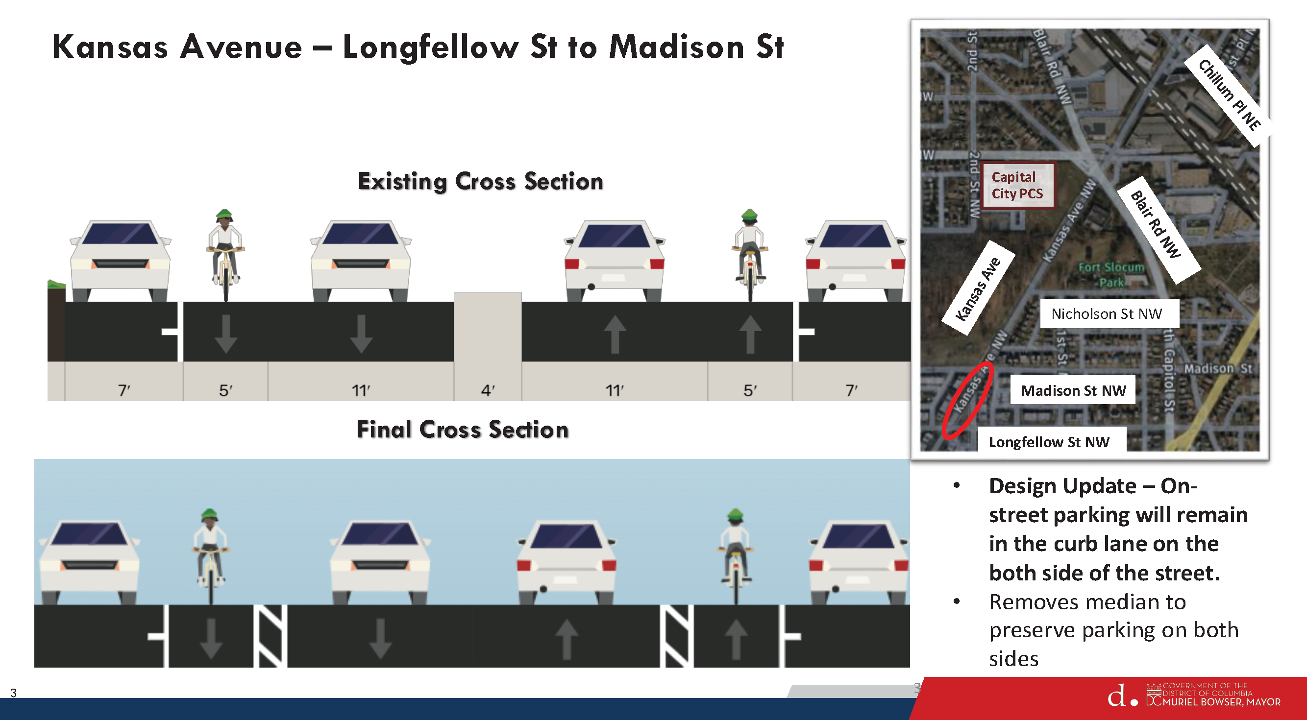
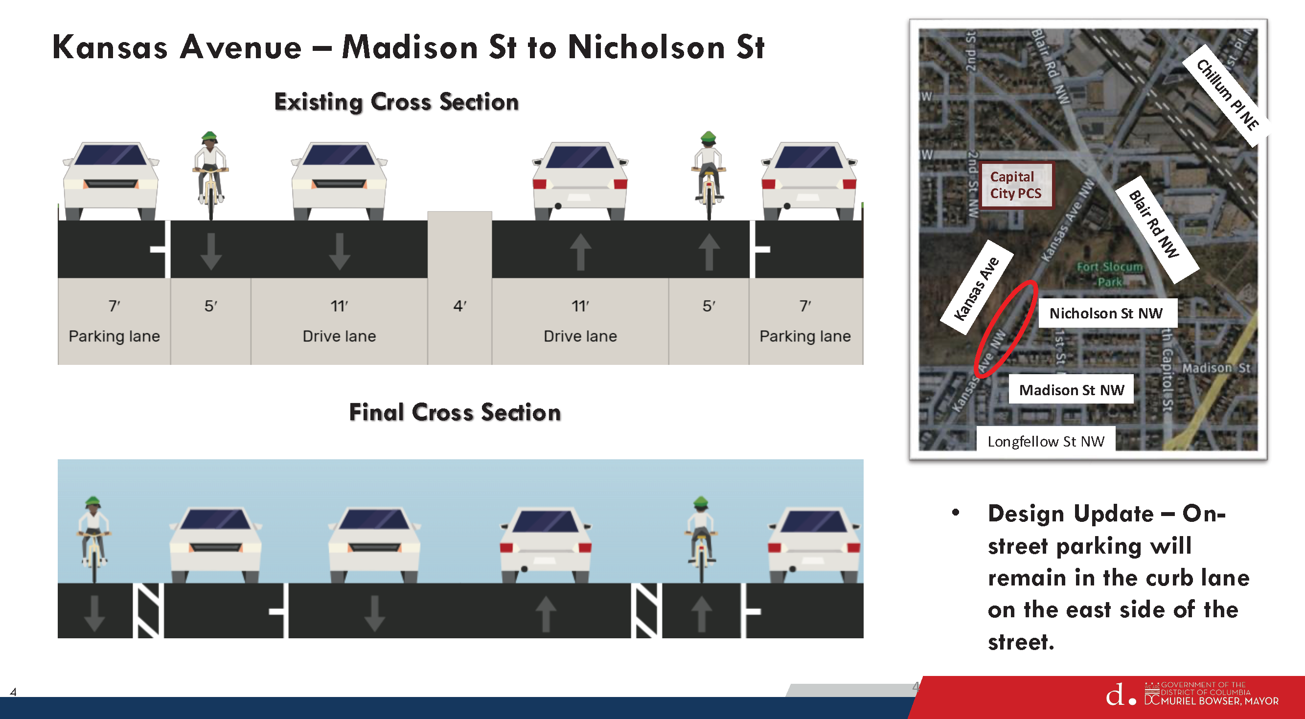
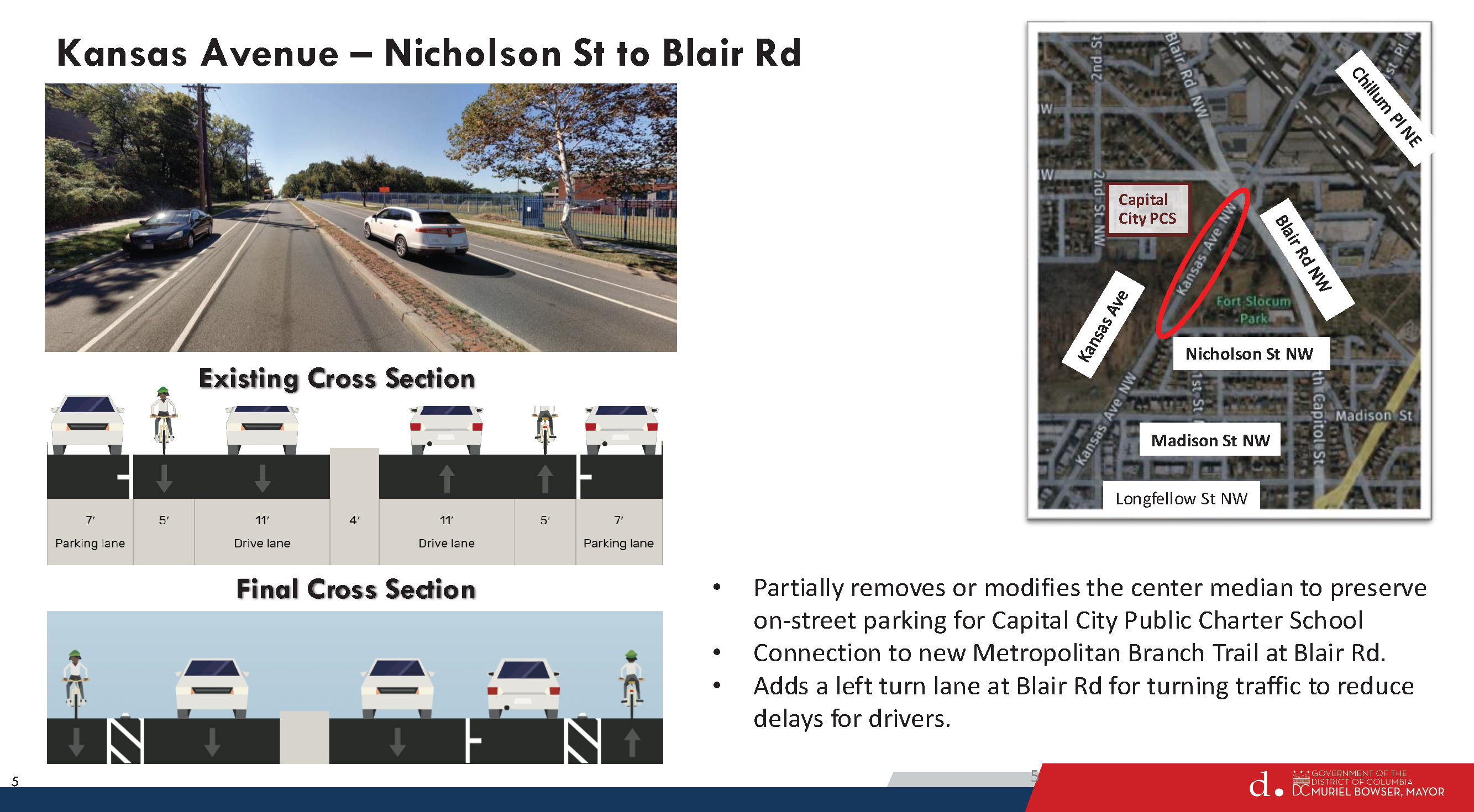
Thanks to Washington Area Bicyclist Association (WABA) for sharing information about DDOT’s December 5, 2025, update for the Kansas Avenue bike lane project.
DDOT originally planned to install fully protected bike lanes on Kansas Avenue from Longfellow Street NW to Chillum Place NE. The updated design will have buffered bike lanes in certain sections to preserve curbside parking.
WABA notes that Kansas Avenue is classified as a minor arterial road and according to DDOT policy, “[a]ny bicycle facilities planned for minor arterial streets will be fully-protected facilities (per NACTO/FHWA guidance).” So the updated design will be a bit of a departure from DDOT policy.
DDOT plans to attend a community-organized meeting on December 10, 2025, at 6pm at Capital City Public Charter School.