Share your thoughts about Vision Zero and safe streets.
The DC Offices of Vision Zero and Highway Safety are working to develop a new plan to reshape street safety efforts. Staff are holding listening sessions to work closely with communities and stakeholders to identify problems and build solutions. These discussions will be part of the top-to-bottom update of the District’s Vision Zero Plan and DC Strategic Highway Safety Plan.
There will be in-person listening sessions across the city. View the full line-up.
The Ward 5 listening session will be on September 21, 10:30am-11:30am at Lamond-Riggs Library.
Complete the online survey here by September 23, 2024, at noon.
Thankfully, that means that the large number of charter buses idling on Galloway Street and along South Dakota Avenue, damaging neighborhood roads, and creating safety hazards in the neighborhood are now gone. Hopefully the next time Metro decides to shut down nearby stations, they will utilize their huge parking lot at Fort Totten station for shuttle buses instead of housing a bunch of buses in the neighborhood.
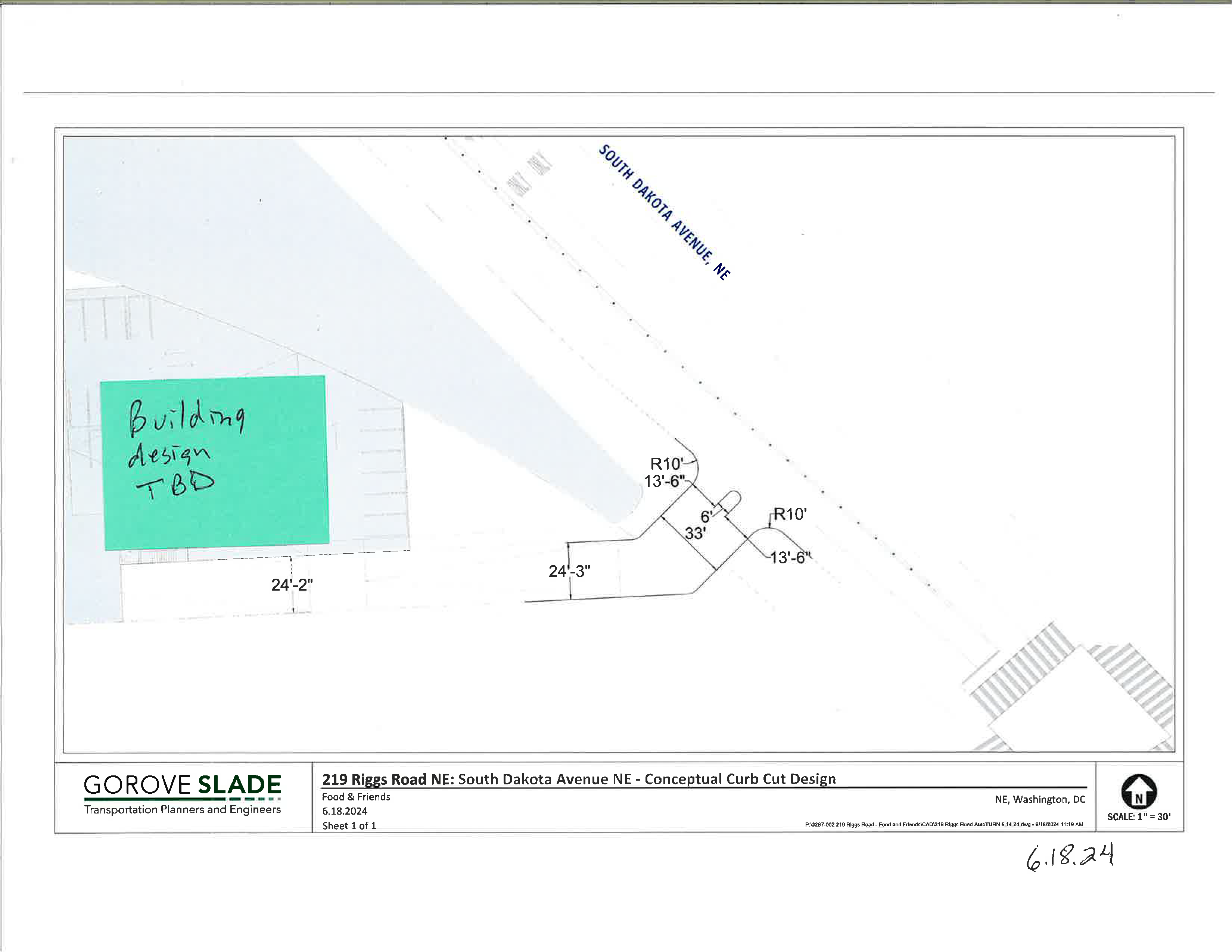
Food & Friends is requesting a curb cut on South Dakota Avenue just north of Kennedy Street NE. The so-called conceptual curb cut request will be the subject of a DC Public Space Committee meeting on August 22, 2024 (application #445416).
Food & Friends is looking to expand its building on the corner of South Dakota Avenue & Riggs Road NE in order to serve more clients. Because the land to the north of the property is District-owned land slated for park space, Food & Friends is looking to expand east towards South Dakota. Food & Friends reps have been to a few meetings, but there are still a lot of unanswered questions. They are calling this a conceptual curb cut project because they contend that their expansion is years away. So apparently the Public Space Committee is going to decide on whether the organization can get a curb cut on South Dakota Avenue in the absence of any information about their building expansion plan.
Conceptual curb cut diagram provided by Food & Friends.
Curb Cut Design
Residents do not have access to public space applications in the city’s online permitting system, which is known as TOPS. What we do know is that they are requesting a pretty sizeable curb cut (leading to a driveway) that looks to be about 33 feet wide on a block that currently has none. In an email to me, they said, “The design includes a 6-foot-wide pedestrian safety island, increased turn radii to alleviate off-tracking, and right-in/right-out movement.” We also know that curb cut access will likely require some amount of public space beyond just sidewalk access because of the way the property lines are drawn. But it is not clear to me based on the one diagram we have exactly how much public space they are requesting.
They say they are requesting this curb cut because they are thinking about building an expanded kitchen facility closer to South Dakota Avenue. So, they will want to reroute food delivery (via 18-wheeler trucks) to the South Dakota side in the future. My understanding is that DDOT is requesting that they close one of their two curb cuts on Riggs Road if they want a curb cut on South Dakota. My understanding is that staff and volunteers would continue to use Riggs to access the parking lot. But it’s a pretty large parking lot, so who knows if that space would be reconfigured as well as part of an expansion plan.
In an email to me, Food & Friends said:
Sixty-five staff, 80 kitchen volunteers, 10 Food & Friends delivery vans, 30 volunteer delivery cars and several vendor delivery trucks (including semi-sized) currently travel to our location daily to prepare and home-deliver 6,000 meals a day to the region’s most vulnerable neighbors. We encourage use of Metro and cycling (we had a cycling team in the 2000s!) and routinely shuttle our staff and volunteers to the Metro station to encourage less vehicles.
Ward 5 Councilmember Zachary Parker submitted a letter in support of the conceptual curb cut to the Public Space Committee.
My thoughts
I do not think anyone has done a really good job of explaining what is really happening here and we’re being asked to comment on something on which we lack full information, specifically impacts to public space. Obviously, Food & Friends plans to build on their property and may even want more public space than what is being publicly discussed. Residents do not have access to applications in TOPS and the ANC is not doing anything regarding this matter. I’m sure most support Food & Friends in their goal to serve more clients around the region.
(Fun fact about me: I served in Americorps in DC before continuing my education. One team member was placed at Food & Friends, and we would have team service days at Food & Friends at their old location in Southeast DC. I’m a big fan and supporter of Food & Friends).
We already know that curb cuts introduce vehicle/pedestrian conflicts. I think a really useful conversation would be how to maximize the amount of public space available to the community, how to minimize harm introduced by installing a new curb cut on the block, and how to safely and most efficiently accommodate the multiple uses that the property owners in the immediate area wish to put in that one little area.
I think it would be super useful for the property owners in the area to talk to one another, particularly the Cafritz Foundation (and their tenants) and Food & Friends. This conversation could also include Metro, National Park Service, and Impact DMV Church. I get the impression they don’t really communicate about their plans and how they are connected to an actual neighborhood, and I think that lack of communication at an institutional level makes it way more difficult than it needs to be to get things done.
Anyways, submit comments to the Public Space Committee at public.spacecommittee@dc.gov by August 20 and send a copy of your comments to CM Parker.
[Ed. Note: Republishing this post because today, August 15, is the last day to submit comments for the first phase of engagement on the South Dakota Avenue Corridor Safety Project. There is still time to provide feedback to DDOT to make sure we address speeding through street design, get needed improvements at key intersections in the neighborhood, and work towards developing a corridor that safely supports multiple means of moving around the neighborhood outside of just private vehicles.]
DDOT is looking at ways to address safety issues on South Dakota Avenue from Bladensburg Road NE to Riggs Road NE.
Let DDOT know what you think about what is needed along the corridor by completing this questionnaire and providing information on this public input map (where you can identify important changes you’d like to see at specific intersections like more visible crosswalks, better pedestrian accommodations, etc).
Councilmember Parker earmarked funds in the FY2024 budget for a road diet on the corridor. While much of the media attention has been erroneously focused on bike lanes, the alternatives for a road diet include potential parking lanes where there are none currently, as well. It is worth taking a look at the presentation slides to see all of the alternatives, including how DDOT could potentially address traffic diversion to side streets or address congestion through, for example, signal timing.
Most agree speeding is a problem on South Dakota. There is a relatively low volume of vehicles during off-peak hours, which makes the wide road ripe for speeding. There are too many crashes and near misses. People feel unsafe crossing the street. Too many pedestrians have been injured or killed walking along the corridor. People want to be able to safely walk and bike to points along the corridor. Everyone wants the situation to be addressed. The question is how to get there.
Project Scope
DDOT is going to study the entire corridor, examine three concepts for a road diet, select one concept, and design and build the concept on one portion of the corridor. DDOT will also make spot improvements at certain intersections, which is why it is really important to indicate on the map where improvements are needed. DDOT plans to start construction on the southern end (near Bladensburg) because they state that is where there is highest need.
DDOT is going to study three options for the corridor.
Option One: 3 lanes with full-time parking
Option one would have three lanes with parking on each side of the street.
Maintains one lane in each direction
Uses curbside space for full-time parking
Center space can be left turn lanes or pedestrian islands depending on needs
(Currently, no parking is allowed on South Dakota except for limited parking on the west side of South Dakota between Galloway and Ingraham (soon extending to Kennedy). A couple of churches closer to the southern end of the corridor use a lane for parking on Sundays.)
Option Two: 3 lanes with parking and two-way protected bike lanes
Option two would have three lanes with parking and a two-way protected bike lane:
Maintains one travel lane in each direction
Uses curbside on one curb face for protected bike lanes
Uses opposite curb for parking
Center space can be left turn lanes or pedestrian islands depending on need
Option Three: 3 lanes with protected bike lanes in each direction
Option three would have three lanes with protected bike lanes in each direction.
Maintains one lane in each direction
Uses curbside space for protected bike lanes
Center space can be left turn lanes or pedestrian islands depending on needs
Project Timeline
DDOT plans to gather data, explore concepts, and gather input before holding a second round of public meetings in fall 2024, having a third round of public meetings in winter 2024/2025, beginning work on design plans in spring 2025, and finally starting construction just on the southern end in summer 2025.
Though DDOT is going to focus the limited construction money on the southern end of the corridor to start, please take the time to provide input to DDOT about neighborhood issues through this public engagement effort. In particular, I think that highlighting problematic intersections and needed safety, mobility, and access improvements in the neighborhood on the public map will be useful given that we know there are no immediate plans for bike lanes on SDA in the neighborhood.
Contacts
Questions may be sent to the project team:
Sayra Molina, Corridor Safety Team sayra.molina2@dc.gov
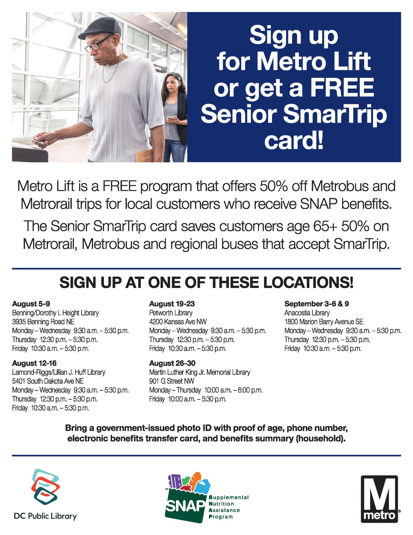
Metro and DC Public Library are partnering to offer Metro Lift and Senior SmarTrip card registration at select library locations. Eligible residents save 50% on bus and rail fares.
Representatives will be at Lamond-Riggs Library August 12-16. 5401 South Dakota Avenue NE Monday – Wednesday 9:30 a.m. – 5:30 p.m. Thursday 12:30 p.m. – 5:30 p.m. Friday 10:30 a.m. – 5:30 p.m.
Bring current government-issued ID with proof of age, phone number, SNAP electronic benefits transfer card, and SNAP benefits summary (household).
Let DDOT know what you think about what is needed along the corridor by completing this questionnaire and providing information on this public input map (where you can identify important changes you’d like to see at specific intersections like more visible crosswalks, better pedestrian accommodations, etc). Give your input by August 15, 2024.
Councilmember Parker earmarked funds in the FY2024 budget for a road diet on the corridor. While much of the media attention has been erroneously focused on bike lanes, the alternatives for a road diet include potential parking lanes where there are none currently, as well. It is worth taking a look at the presentation slides to see all of the alternatives, including how DDOT could potentially address traffic diversion to side streets.
Most agree speeding is a problem on South Dakota. There is a relatively low volume of vehicles during off-peak hours, which makes the wide road ripe for speeding. There are too many crashes and near misses. People feel unsafe crossing the street. Too many pedestrians have been injured or killed walking along the corridor. People want to be able to safely walk and bike to points along the corridor. Everyone wants the situation to be addressed. The question is how to get there.
Project Scope
DDOT is going to study the entire corridor, examine three concepts for a road diet, select one concept, and design and build the concept on one portion of the corridor. DDOT will also make spot improvements at certain intersections, which is why it is really important to indicate on the map where improvements are needed. DDOT plans to start construction on the southern end (near Bladensburg) because they state that is where there is highest need.
DDOT is going to study three options for the corridor.
Option One: 3 lanes with full-time parking
Option one would have three lanes with parking on each side of the street.
Maintains one lane in each direction
Uses curbside space for full-time parking
Center space can be left turn lanes or pedestrian islands depending on needs
(Currently, no parking is allowed on South Dakota except for limited parking on the west side of South Dakota between Galloway and Ingraham (soon extending to Kennedy). A couple of churches closer to the southern end of the corridor use a lane for parking on Sundays.)
Option Two: 3 lanes with parking and two-way protected bike lanes
Option two would have three lanes with parking and a two-way protected bike lane:
Maintains one travel lane in each direction
Uses curbside on one curb face for protected bike lanes
Uses opposite curb for parking
Center space can be left turn lanes or pedestrian islands depending on need
Option Three: 3 lanes with protected bike lanes in each direction
Option three would have three lanes with protected bike lanes in each direction.
Maintains one lane in each direction
Uses curbside space for protected bike lanes
Center space can be left turn lanes or pedestrian islands depending on needs
Project Timeline
DDOT plans to gather data, explore concepts, and gather input before holding a second round of public meetings in fall 2024, having a third round of public meetings in winter 2024/2025, beginning work on design plans in spring 2025, and finally starting construction just on the southern end in summer 2025.
Though DDOT is going to focus the limited construction money on the southern end of the corridor, please take the time to provide input to DDOT about neighborhood issues through this public engagement effort. In particular, I think that highlighting problematic intersections and needed safety, mobility, and access improvements in the neighborhood on the public map will be useful given that we know there are no immediate plans for bike lanes on SDA in the neighborhood.
Contacts
Questions may be sent to the project team:
Sayra Molina, Corridor Safety Team sayra.molina2@dc.gov
There will be a special North Michigan Park Civic Association meeting held:
Date: Wednesday, August 7, 2024
Time: 6:00 pm to 9:00 pm
Location: Faith United Church 4900 10th Street NE Washington, DC 20017
The guest for this meeting is the Department of Transportation (DDOT) to discuss proposed safety changes for South Dakota Avenue. One of the proposed changes is adding bike lanes along the avenue.
This is your opportunity to voice your concern and to offer alternative measures for safety along the avenue.
The District Department of Transportation (DDOT) is soliciting public comment on the 90% design of the Riggs Road NE two-way cycletrack (NOI #24-150 PSD; 90% design plan). This is the proposed cycletrack on eastbound Riggs using part of the existing dedicated right-turn only lane between South Dakota Avenue and 1st Place NE. DDOT is reissuing the NOI for this project after it stalled last year. The project sits in ANC 5A09. Send comments to bike.lanes@dc.gov by July 23, 2024.
DDOT states:
DDOT proposes to reconfigure the 100 block of Riggs Road between First Place NE and South Dakota Ave NE to remove the curbside eastbound travel lane for 800 feet and convert that space to a two-way protected bike lane as shown in the attached plans.
The purpose of this change is to assist cyclists in crossing under the railroad tracks to reach the Metropolitan Branch Trail.
We are re-issuing this NOI at the 90% design stage to solicit public feedback through the ongoing development stages of this project.
Rendering of proposed cycletrack from NOI
It is worth looking at the 90% design plan for details. For example, DDOT expects that people on bikes will follow the pedestrian signal rather than having a separate bike signal. It looks like DDOT plans to install a yellow flex post in the cycletrack at the corner of 1st Pl & Riggs that will hopefully stop cars from entering the cyletrack. Plenty of other details to comment on.
Send comments to bike.lanes@dc.gov by July 23, 2024.
DDOT and Ward 5 Councilmember Zachary Parker recently held two kickoff meetings for the South Dakota Avenue NE Corridor Safety Study. DDOT is looking at ways to address issues on South Dakota from Bladensburg Road NE to Riggs Road NE.
Let DDOT know what you think about what is needed along the corridor by completing this questionnaire and providing information on this public input map (where you can identify important changes you’d like to see at specific intersections like more visible crosswalks, better pedestrian accommodations, etc).
Councilmember Parker earmarked funds in the FY2024 budget for a road diet on the corridor:
“fund efforts to improve safety on the corridor in the short term, preferably by constructing a road diet on a segment of the corridor […] the Committee recommends that DDOT consider either the segment between Bladensburg Road and Monroe Street NE or the segment between Sargent Road NE and RiggsRoad NE.”
Most agree speeding is a problem on South Dakota. There is a relatively low volume of vehicles during off-peak hours, which makes the wide road ripe for speeding. There are too many crashes and near misses. People feel unsafe crossing the street. Too many pedestrians have been injured or killed walking along the corridor. People want to be able to safely walk and bike to points along the corridor. Everyone wants the situation to be addressed. The question is how to get there.
Project Scope
DDOT is going to study the entire corridor, examine three concepts for a road diet, select one concept, and design and build the concept on one portion of the corridor. DDOT plans to start construction on the southern end (near Bladensburg) because they state that is where there is highest need.
DDOT is looking at three options for the corridor.
Option One: 3 lanes with full-time parking
Option one would have three lanes with parking on each side of the street.
Maintains one lane in each direction
Uses curbside space for full-time parking
Center space can be left turn lanes or pedestrian islands depending on needs
(Currently, no parking is allowed on South Dakota except for limited parking on the west side of South Dakota between Galloway and Ingraham (soon extending to Kennedy). A couple of churches closer to the southern end of the corridor use a lane for parking on Sundays.)
Option Two: 3 lanes with parking and two-way protected bike lanes
Option two would have three lanes with parking and a two-way protected bike lane:
Maintains one travel lane in each direction
Uses curbside on one curb face for protected bike lanes
Uses opposite curb for parking
Center space can be left turn lanes or pedestrian islands depending on need
Option Three: 3 lanes with protected bike lanes in each direction
Option three would have three lanes with protected bike lanes in each direction.
Maintains one lane in each direction
Uses curbside space for protected bike lanes
Center space can be left turn lanes or pedestrian islands depending on needs
Project Timeline
DDOT plans to gather data, explore concepts, and gather input before holding a second round of public meetings in fall 2024, having a third round of public meetings in winter 2024/2025, beginning work on design plans in spring 2025, and finally starting construction just on the southern end in summer 2025.
Ways to Give Input
Let DDOT know what you think about what is needed along the corridor by completing this questionnaire and providing information on this public input map (where you can identify important changes you’d like to see at specific intersections like more visible crosswalks, better pedestrian accommodations, etc).
Though DDOT is going to focus the limited construction money on the southern end of the corridor, please take the time provide input to DDOT about neighborhood issues through this public engagement effort.
(I am going to exercise restraint from getting too soapboxy about how it would have been amazing if our city agencies would have required safe street design while the streets have been torn up for all of the development plus the city’s own street reconfiguration on the northern end of the corridor the past several years. Would have been amazing if our planning agency did not greenlight a new drive-thru on South Dakota on the northern end. Please complete the surveys & advocate for funding to complete the entire corridor.)
As part of its bus network redesign, Metro is looking to consolidate some of its bus stops. View the full list of bus stops that Metro is proposing to eliminate: Metro Bus Stop Consolidation Report (May 2024). Metro states:
Metro used our Board adopted Service Guidelines, which provide guidelines of the average number of bus stops per mile for different kinds of service. We focused on stops that were about 660 feet apart or less and then assessed ridership at the stop and the availability of safe access for customers. For stops that were close together with low ridership or without safe pedestrian access were considered for consolidation.
Share your input with Metro
In this post, we discussed some of the neighborhood impacts of the 2025 Network Proposal. Residents should also comment on the proposed elimination of bus stops. Remember to provide input to Metro at https://betterbus.wmata.com/share by 5:00 pm on July 15, 2024.
Proposed Bus Stop Consolidation Neighborhood Impacts
Virtual Public Hearing Tuesday, June 18, 2024, 10:00 a.m.-12:00 p.m. Meeting Code: 490 122 856#
Virtual Public Hearing Monday, June 24, 2024, 4:00 p.m.-6:00 p.m. Meeting Code: 787 960 816#
Metro is holding popup events about the 2025 Network Proposal around the region.
Pop-Up @ Rhode Island Ave Metro Station Monday, June 17, 2024 3:00 – 7:00 p.m. Rhode Island Ave Metro Station 919 Rhode Island Ave NE Washington DC 20018
Ward 5 Councilmember Zachary Parker cohosted a virtual Ward 5 meeting on June 3.
Ward 4 Councilmember Janeese Lewis George is cohosting a meeting with Metro on June 27 at 6:30 pm at Coolidge High School.
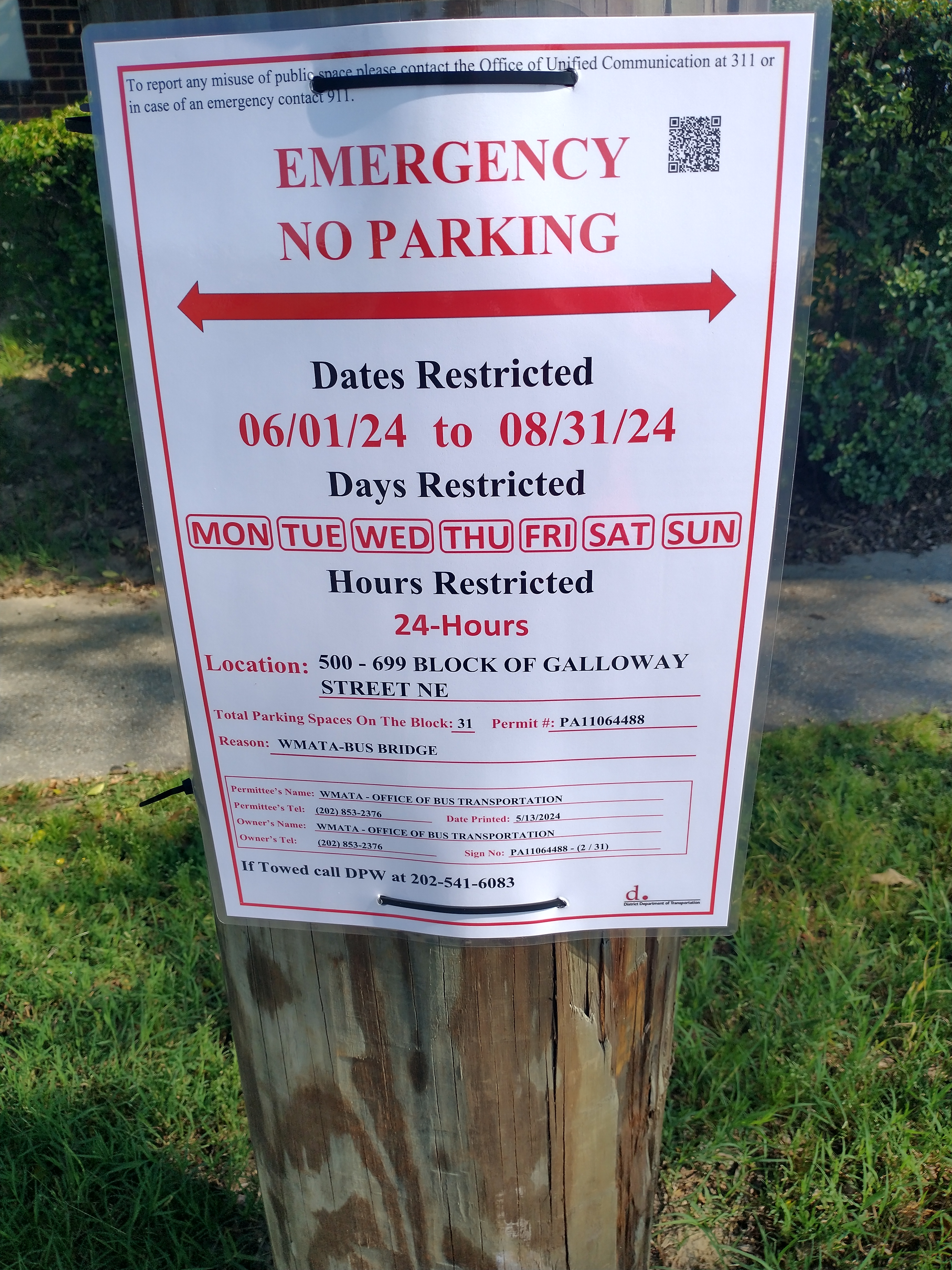
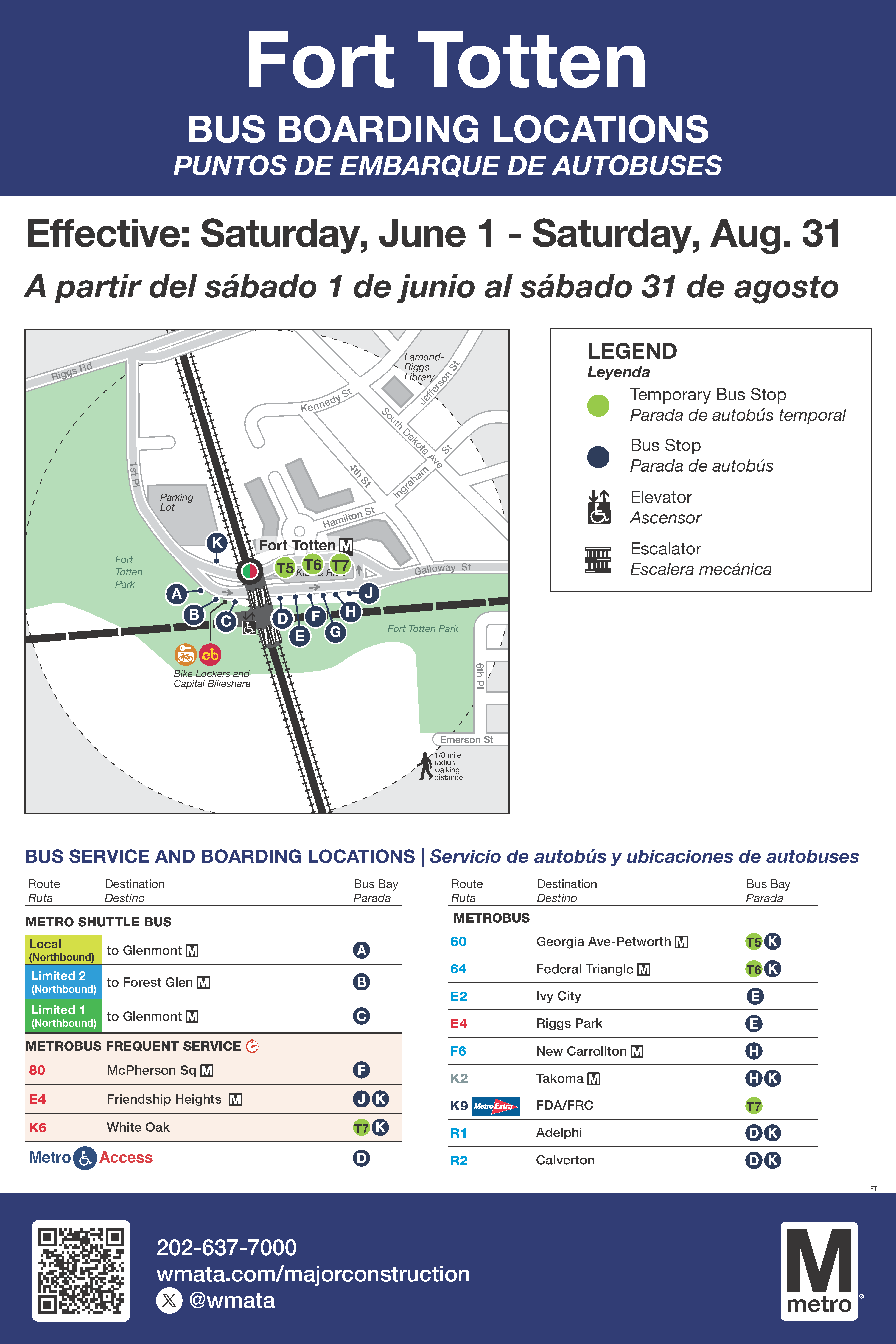
Heads up. Due to Metro’s upcoming three-month partial red line closure, parking will be restricted on Galloway Street from South Dakota Avenue to 7th Street NE to make room for a bus bridge. No parking will be allowed at any time from June 1 to August 31, 2024.
Metro will be doing construction on a good chunk of the red line starting June 1, 2024. Takoma station will be closed June 1 – June 29, 2024. Glenmont, Wheaton, Forest Glen, & Silver Spring stations will be closed June 1 – Aug 31, 2024. Plan accordingly.
The three-month closure will allow the Maryland Transit Administration Purple Line project to build a new mezzanine at Silver Spring which will improve the connectivity between the Paul S. Sarbanes Transit Center and the future Purple Line Station with Metro.
The outage will also provide Metro with an opportunity to complete maintenance, repairs, and customer experience improvements on the Red Line, condensing eight months of weekend closures and disruptions into the summer months.
SERVICE INFORMATION
June 1 – June 29, 2024
Free shuttle buses replace trains between Glenmont and Fort Totten
Stations closed: Glenmont, Wheaton, Forest Glen, Silver Spring, and Takoma
Green Line service and Red Line service to/from Shady Grove available at Fort Totten
June 30 – Aug. 31, 2024
Free shuttle buses replace trains between Glenmont and Takoma
Stations closed: Glenmont, Wheaton, Forest Glen, and Silver Spring
Green and Red Line service available at Fort Totten
Takoma Station reopened. Customers traveling between the closed stations and Takoma should use the local shuttle bus, or limited stop shuttle bus to the Red Line via Fort Totten
TRAVEL ALTERNATIVES
Free Shuttle Service
Free local, limited-stop, and express shuttles available during Metrorail operating hours. Shuttles will be available at all closed stations for customers with accessibility needs. To request an accessible shuttle, please ask a Metro team member onsite.
Saturday, June 1 to Saturday, Aug. 31, 2024
Local: Local service stopping at all stations between Glenmont, Wheaton, Forest Glen, Takoma, and Fort Totten
AM/PM Peak – approximately every 4 minutes
All other times, weekends, and holidays – approximately every 8 minutes
Estimated travel time: 61 minutes between Glenmont and Fort Totten during peak traffic
Limited 1: Limited-stop service between Glenmont, Wheaton, and Fort Totten
AM/PM Peak – approximately every 4 minutes
All other times, weekends, and holidays – approximately every 8 minutes
Estimated travel time: 37 minutes between Glenmont and Fort Totten during peak traffic
Limited 2: Limited-stop service between Forest Glen, Silver Spring, and Fort Totten
AM/PM Peak – approximately every 4 minutes
All other times, weekends, and holidays – approximately every 8 minutes
Estimated travel time: 25 minutes between Glenmont and Fort Totten during peak traffic
Express: Express service between Silver Spring and Metro Center (pick up location 12th & G streets NW)
Weekday only – approximately 4-8 minutes all day
Estimated travel time: 39 minutes between Silver Spring and Metro Center during peak traffic
Public Meeting Notice: South Dakota Avenue Corridor Safety Project
(WASHINGTON, DC) —The District Department of Transportation (DDOT), in partnership with Ward 5 Councilmember Zachary Parker, invites you to attend public meetings for the South Dakota Avenue Corridor Safety Project from Riggs Road NE to Bladensburg Road NE. DDOT will be hosting two meetings: a virtual meeting on Thursday, May 30, 2024, and an in-person meeting on Saturday, June 1, 2024.
The meetings are an opportunity for community members to share their feedback on ongoing issues, challenges, and opportunities for the corridor. DDOT staff will also provide information on existing conditions and will be available to answer questions and gather comments.
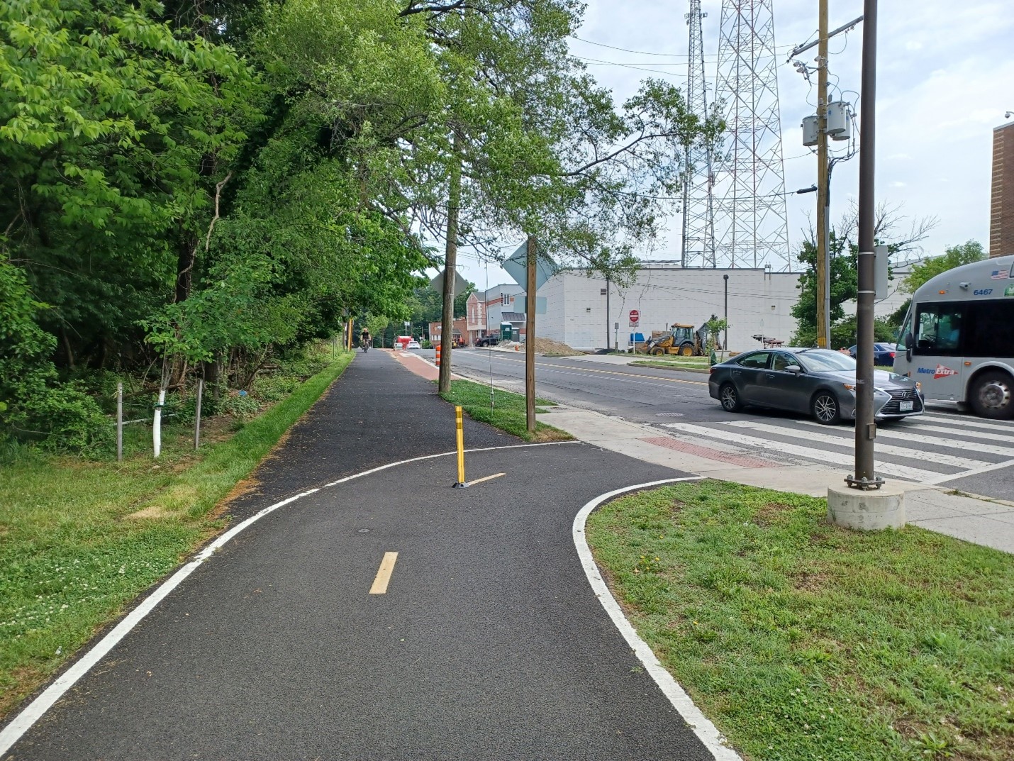
The Metropolitan Branch Trail is a multiuse path for people to walk, bike, jog, and scoot. The trail is being built in stages between Washington Union Station and Silver Spring, roughly parallel to the Metropolitan Branch railroad tracks and the Metrorail Red Line. The trail’s Brookland to Fort Totten section opened in 2022.
The asphalt is now open north from the Fort Totten trailhead along 1st Place NE and west along Riggs Road to 1st Street NE. There will probably be some finishing touches, such as striping, when all is said and done, but it’s open for use now.
Looking north along 1st Place NELooking south along 1st Place NELooking west along Riggs Road NELooking east along Riggs Road NE
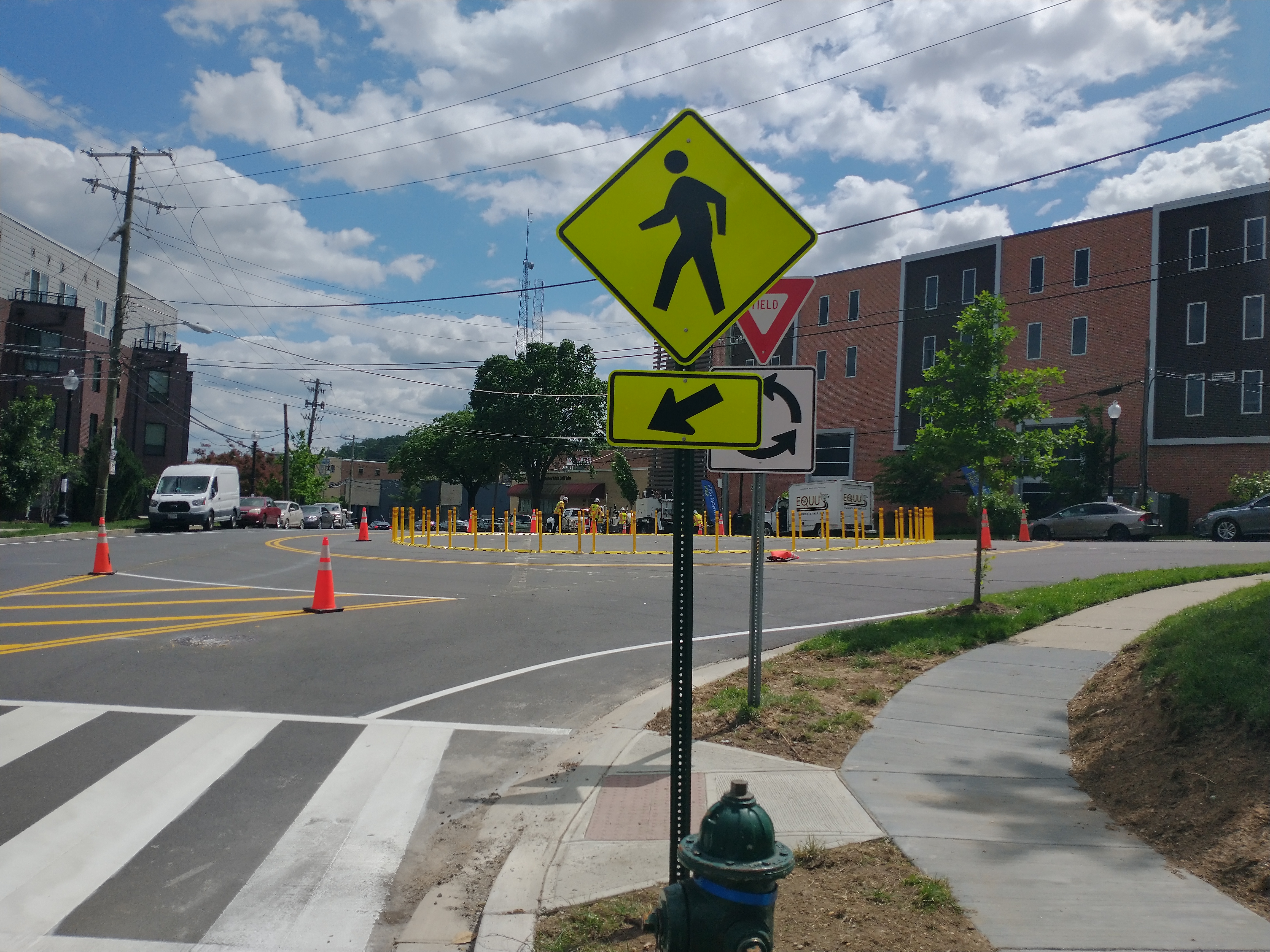
A few days ago, DDOT contractors started work to install a roundabout at the 2nd/3rd Street NE intersection.
We described what the final product will look like in this post. People in cars exiting Walmart’s garage will have to turn right. No more abrupt U-turns in the middle of the road. Two new crosswalks are being installed.
NOI design for 2nd/3rd Street NE.
I have seen people driving the wrong way as installation progresses, so exercise caution over the next few days while workers are in the road.
Wrong way driver in roundabout.
Hopefully once all the signs and arrows are installed, people will understand it’s pretty easy to navigate. Drive on the right around the circle and yield to traffic in the circle.
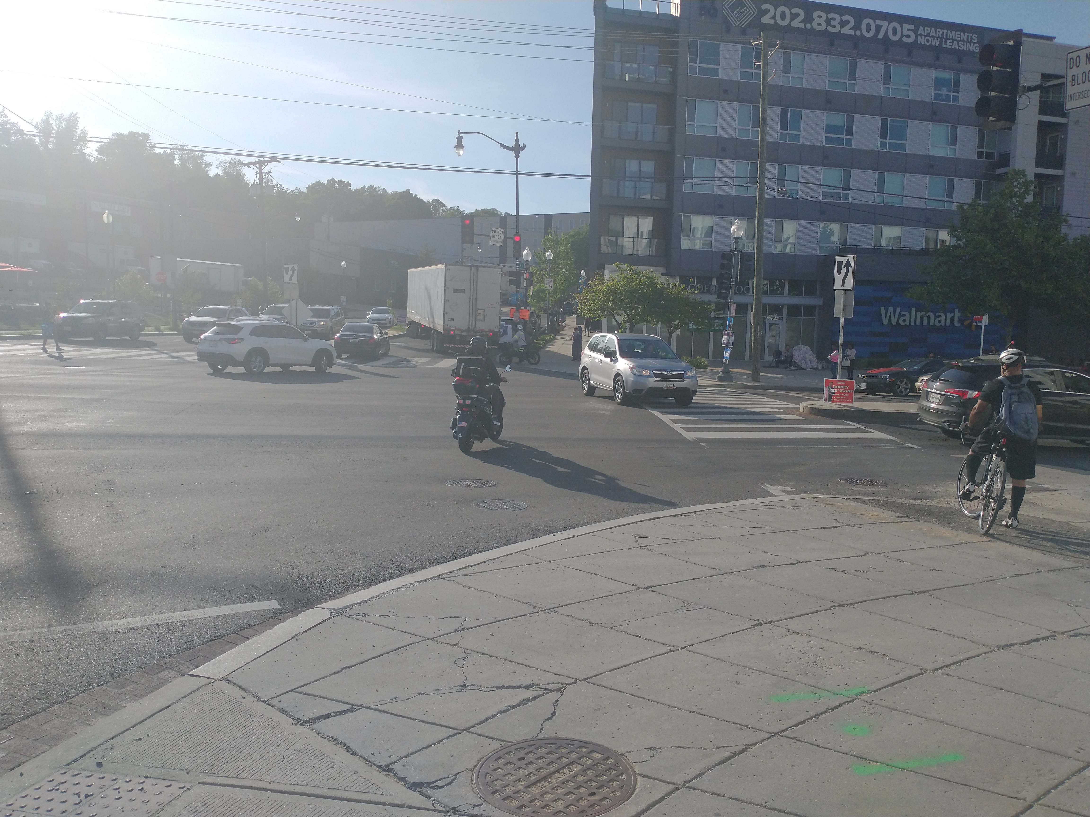
DDOT still needs to address the intersection at South Dakota Avenue & Riggs Road NE that was poorly reconfigured in 2011 to eliminate the slip lanes. The intersection is too wide. All of the turning radii are completely off. People think they can make U-turns when they cannot. People always block the intersection during the morning commute. And people are still parking right up to the crosswalk and intersection on the corner where Wing Stop will be opening. A few days ago a driver of a large truck got stuck for over 10 minutes trying to make the turn with parked cars in the way.
Absurdity at South Dakota Avenue/3rd Street/Riggs Road NE, May 13, 2024.
It would be nice to have the parking addressed, at a minimum. Something tells me it will continue to take years for simple stuff to be addressed though.
In any case, pack some patience as people get used to the new traffic pattern at 2nd & 3rd streets.
Free shuttle buses replace trains between Takoma and Rhode Island Avenue. Normal Service frequencies with trains operating between Shady Grove and Rhode Island Avenue and between Glenmont and Takoma. No Red Line service at Brookland and Fort Totten stations.
Green Line
Trains single track between Naylor Road and Branch Avenue. Trains run every 8 minutes between Greenbelt and Southern Avenue and every 16 minutes between Southern Avenue and Branch Avenue.