
North Michigan Park neighbor Robert Oliver passed along the presentation that Office of Planning Associate Director Ryan Hand gave to North Michigan Park Civic Association (NMPCA) about draft changes to the Future Land Use Map (FLUM). These draft changes are just one step in OP’s Comprehensive Plan rewrite, which OP is calling DC2050.
See OP Draft FLUM Presentation to North Michigan Park Civic Association (May 2026)
Submit comments on the draft FLUM by May 17, 2026.
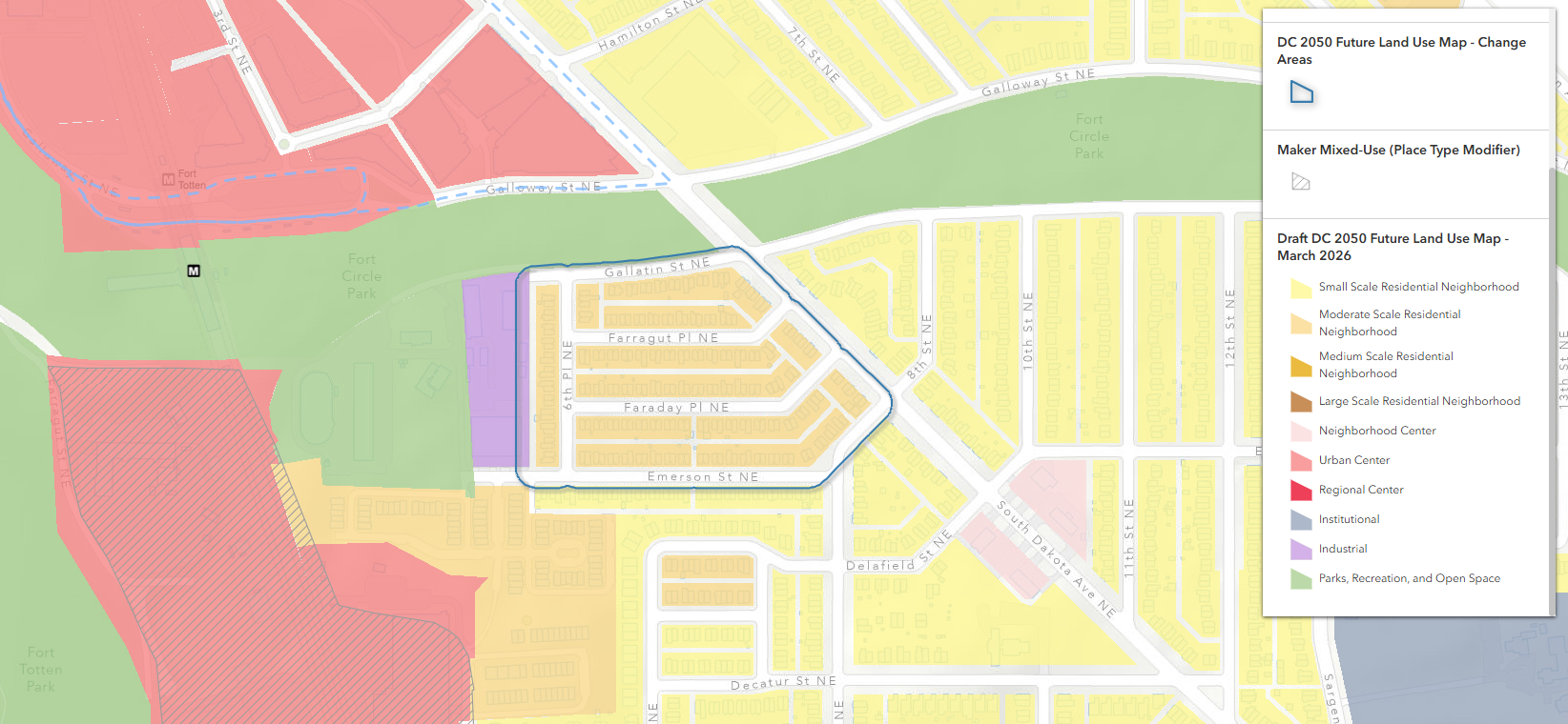
There is a tiny section of North Michigan Park just south of Fort Totten Park that OP wants to change from “small-scale residential” to “moderate-scale residential.” Residents at the NMPCA meeting on May 6 were not on board this proposal.
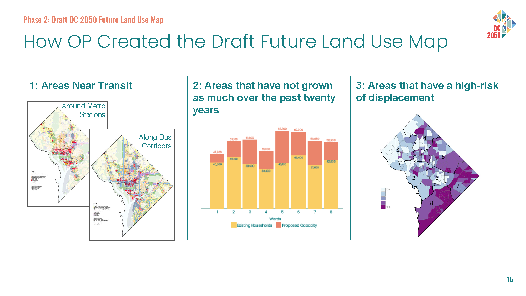
I noted in this post that OP Director Anita Cozart stated that the intent of the change is to possibly make way for small apartments or accessory dwelling units (ADUs) (though ADUs are already permissible). Mr. Hand echoed that rationale stating that OP sought to “up-FLUM” areas near Metrorail and high frequency bus corridors and also areas that have not grown as much over the past 20 years. At the same time, Mr. Hand noted that OP also wants to be cautious about making changes to areas too quickly that are at high risk of displacement.
Mr. Hand acknowledged concerns from residents that this change could incentivize developers to try to buy out homeowners to tear down the existing semi-detached homes and build multifamily buildings in their place. In response to a resident who brought up the explosive growth in Columbia Heights, Mr. Hand stated that the development that took place in Columbia Heights was a different situation at a unique moment in the city’s history. So OP does not seem too concerned about something similar happening in North Michigan Park (or nearby).
I noted in a previous post that I do not quite understand why OP is drawing the map the way they are. This meeting with Mr. Hand did provide confirmation that it really is kind of random. OP is targeting areas near Metrorail, hence the change to this small section of North Michigan Park. On the Ward 4 side, OP selected areas along Riggs Road to up-FLUM because they are along a high-frequency bus corridor. It is still puzzling to me that OP chose not to account for for-sale and rental housing that can be built in areas identified as institutional areas on the FLUM.
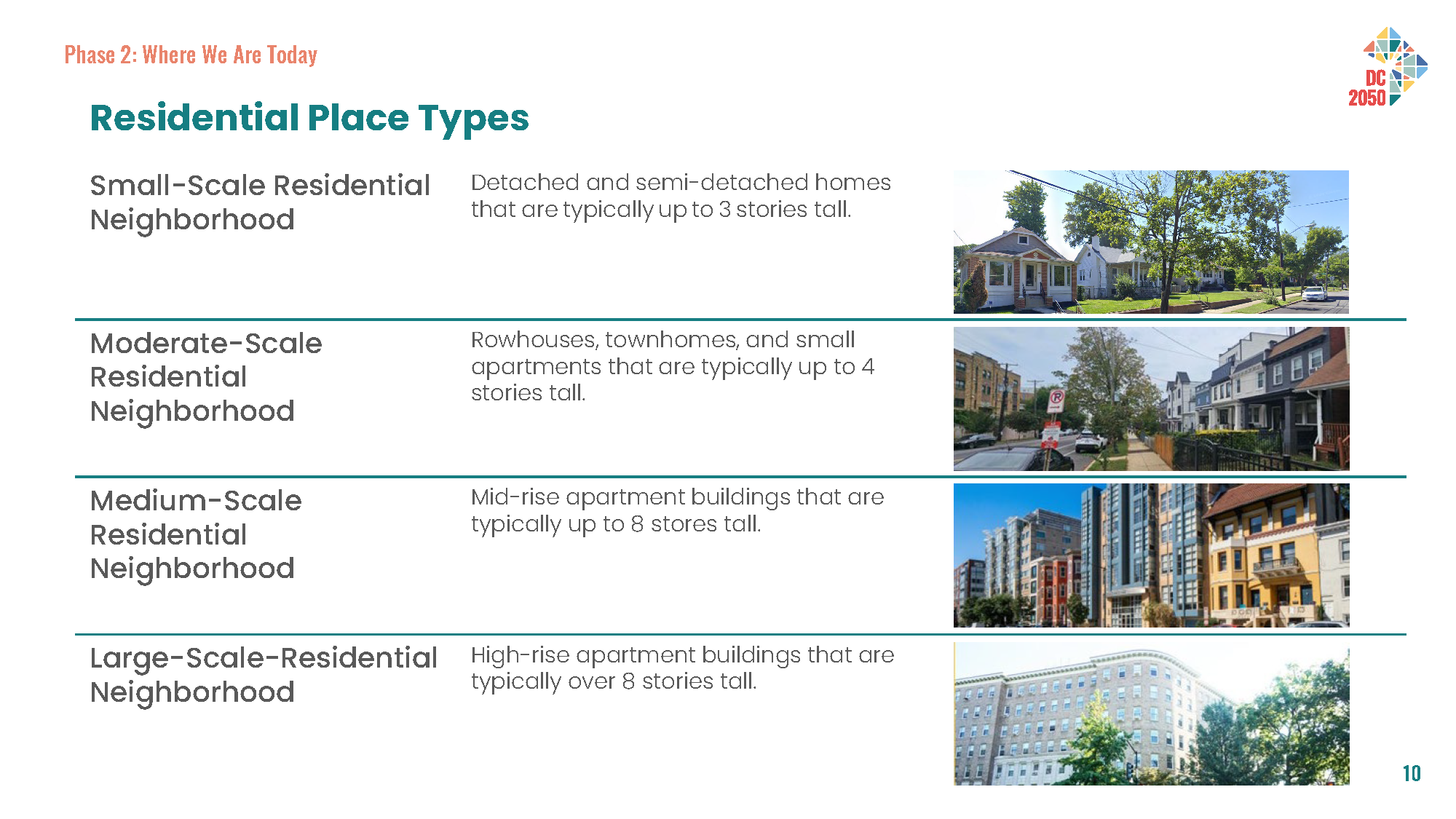
As it stands the amount of housing that OP is saying can be built in areas with existing, occupied semi-detached homes is a bit of fiction whereas there can be real numbers attached to institutional areas with vacant land on the map. Also, while I get the move to the new “place types” concept, I do think there is a bit of worthwhile distinction lost when one lumps semi-detached and rowhomes with apartment buildings in one category.
ANC Commissioner Bocoum (5A09) is having a virtual single member district (SMD) meeting tonight about the changes in this small section of North Michigan Park. I anticipate that ANC 5A will want to vote on the issue at their meeting on May 27. Mr. Hand told the commissioners at the North Michigan Park meeting that the ANC can submit their resolution to OP after this meeting. Mr. Hand noted that the Council changed the law so that OP has to give “great weight” to ANC resolutions at this draft phase (and not just at the final phase).
I do not know if OP plans to formally extend the deadline for everyone, so if you plan to submit individual comments, be sure to submit your comments by May 17.
To receive updates about the Comprehensive Plan process, join OP’s mailing list.

North Michigan Park residents (especially those who live within OP’s proposed Comprehensive Plan “Change Area”) may be interested in what Brookland residents have to say about OP’s proposed “Change Areas” in Brookland:
No Up-FLUMing or Up-Zoning Our Homes!
On March 17, 2026, the DC Office of Planning (OP) issued proposed “Change Areas” to the DC 2050 Future Land Use Map (FLUM) for the District of Columbia. The FLUM is an integral part of the city’s Comprehensive Plan. Together they serve as a guide to growth and development across DC. The FLUM categorizes land across the city (e.g., for low density residential, high density commercial, park space, etc.) and expresses official and legal city policy about future land use and development. The FLUM categories, in turn, correspond to zoning and set the stage for future re-zoning.
Most of Brookland is presently designated on the existing FLUM as “low density residential”. This designation characterizes neighborhoods largely consisting of single-family and semi-detached 2-3 story homes with front, back, and side yards. OP’s March 17th proposal identifies multiple areas throughout Brookland to be re-designated as “moderate density residential”. If OP’s proposal is adopted and these “Change Areas” are re-zoned, it will allow bigger, taller buildings, decreased yard space, more dwelling units per lot, and potentially more commercial uses.
No Up-FLUMing or Up-Zoning Our Homes!
We oppose the Office of Planning’s proposed Future Land Use Map (FLUM) “Change Areas” in Brookland for the following reasons:
Up-FLUMing or Up-Zoning our Brookland homes is not the answer.
Signed,
Caroline Petti and Verna Clayborne
I agree with Caroline’s analysis. We in North Michigan Park face the same challenges and much of what Ms. Petti has said is applicable to our situation. According to the Change Area 5.1 information shared by the DC Office of Planning (DCOP) during the May 6th North Michigan Park Civic Association Meeting, 90 units of housing is under consideration within an area bounded by South Dakota Avenue (North), Eight Street (East), Emerson Street (South), and 6th Place (West). This area contains 215 semi-detached homes, and all are in R2 zones.
So, the Zoning regulation must be changed to permit 4-unit apartments that require two contiguous lots to support one apartment building – a single R2 lots is too small. The proposed 90 units of housing could replace 20% of existing housing. That influx of housing will certainly change the character of the community and spark a speculative real estate frenzy that could impact property tax rates.
We need to keep our elected officials, at all levels, aware of our thoughts as the DCOP 2050 Project continues.