
DC’s Office of Planning released a Draft Future Land Use Map (FLUM) for DC’s next Comprehensive Plan that OP is calling DC 2050. The FLUM is designed to provide a view of where different land uses are recommended or planned. The FLUM is important because it can be used to support changes to land use. (Recall that McDonald’s used their requested change to the FLUM to support its quest to upzone their parcel for the sole purpose of putting in a drive-thru as a matter of right. OP signed off on that).
OP is using an approach called Place Types that they say will help make it easier to understand how a property can be used.
Attend OP’s Phase 2 spring workshop on March 21 at Martin Luther King, Jr. Library at 11am to give input on the Draft FLUM.
Draft FLUM Changes
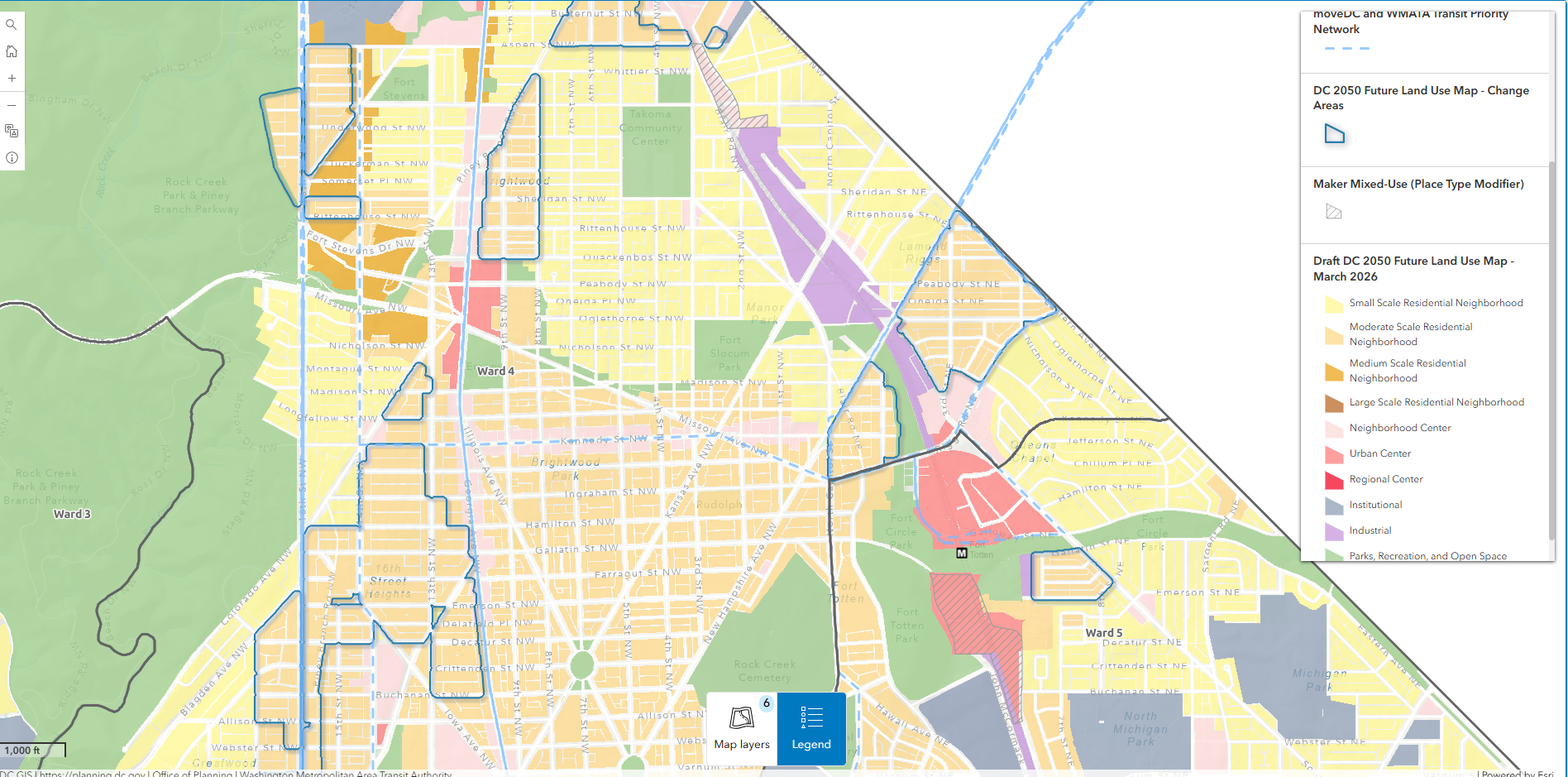
OP states the changes in the Draft FLUM are designed to do three things:
- Increase opportunities for more housing along high-frequency bus routes and metro stations, to direct more housing to neighborhoods that haven’t had a lot of development;
- Distribute housing opportunities across DC’s wards, to ensure fair and balanced housing development across the District; and
- Allow more types of housing and amenities, to meet the diverse needs of DC’s current and future residents.
OP also provided an explanation of the considerations that went into the Deaft FLUM:
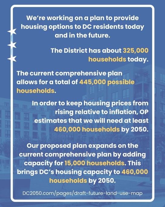
The current Future Land Use Map has an estimated capacity of 445,000 total households. In order to keep housing prices from rising relative to inflation, OP estimates that we will need at least 460,000 households by 2050. The DC 2050 Future Land Use Map proposes adding capacity to meet this new target by identifying new land use changes near transit, in areas that have grown less over the past twenty years, and with additional analysis in areas with the highest risk of displacement.
See OP explainer on Draft FLUM.
One thing to keep in mind is that Riggs Park has an approved Riggs Road/South Dakota Avenue Area Development Plan (sometimes referred to as a small area plan) for the commercial corridor. I previously asked OP reps how they intend to incorporate approved plans, which are consensus documents, into the new Comprehensive Plan. They said that for plans approved before a certain year, the plans would be incorporated into the Comp Plan through the FLUM. I do not remember the year OP stated, but it would cover our neighborhood plan, which was approved in 2009.
I do not remember what OP said about small area plans in progress or plans approved after a certain year. It would probably be helpful for OP to put all of this in the explanation.
Check out OP’s DC 2050 website. It has lots of resources to help residents understand how OP is approaching the Comp Plan rewrite.
If you would like to give feedback on the Draft Flum, attend tomorrow’s workshop or stay tuned for OP’s survey.

love a lot of these changes but I really wish they would have changed some of the industrial sites around the Fort Totten metro to mixed use or residential (particularly the one right next to the Metro stop where Magnolia is)
I’m a homeowner in Riggs Park (near the intersection of Hamilton and 11th) and would really like to see us upzoned to allow for more multi-family apartment buildings. I want friends and family to be able to move to the neighborhood, and I want more stores, cafes, and restaurants in walking distance.
With a few more multi-family apartment buildings we could easily have all of this.