The District Department of Transportation (DDOT) is once again administering the District E-Bike Incentive Program. The application cycle will run February 1, 2026, through February 21, 2026.
This application cycle is open only to District residents enrolled in the Supplemental Nutrition Assistance Program (SNAP), Temporary Assistance for Needy Families (TANF), Medicaid, or the DC Healthcare Alliance.
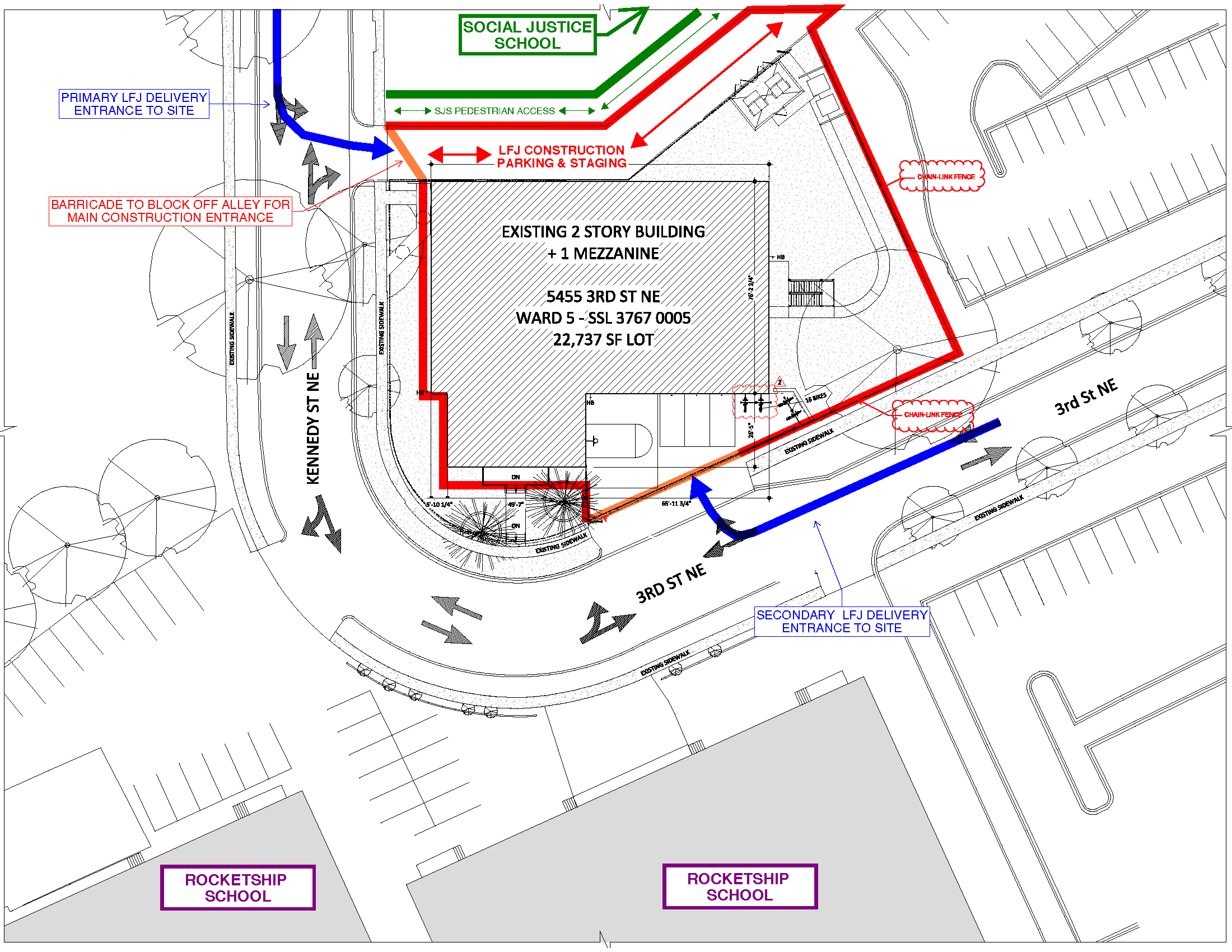
Eligible residents can apply online at ddot.dc.gov/ebikes or at in-person application events held during the application window at various community partner locations. All applicants must reapply regardless of whether an application was submitted during a previous application cycle. Details about application events will be listed on the District E-Bike Incentive Program’s website.
Selected applicants will receive a voucher of up to $1,500 that can be used toward the purchase of an e-bike, helmet, and bicycle lock at authorized retailers. Recipients will be chosen at random.
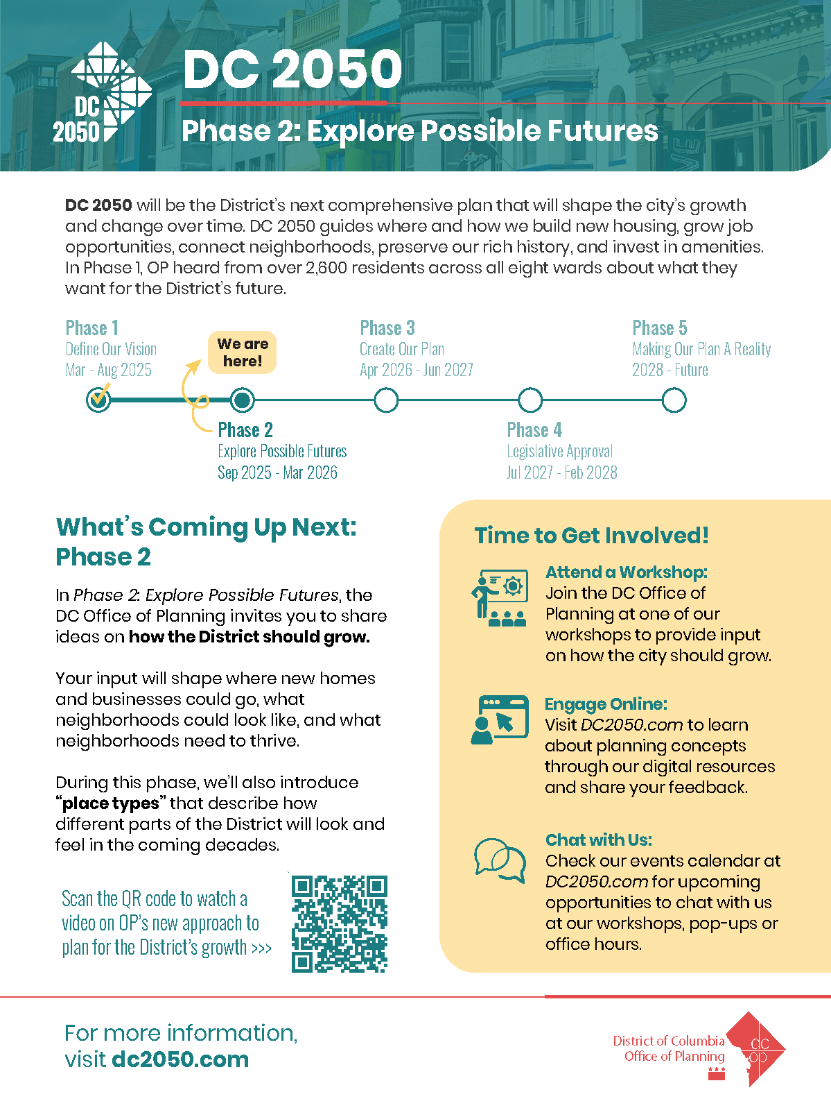
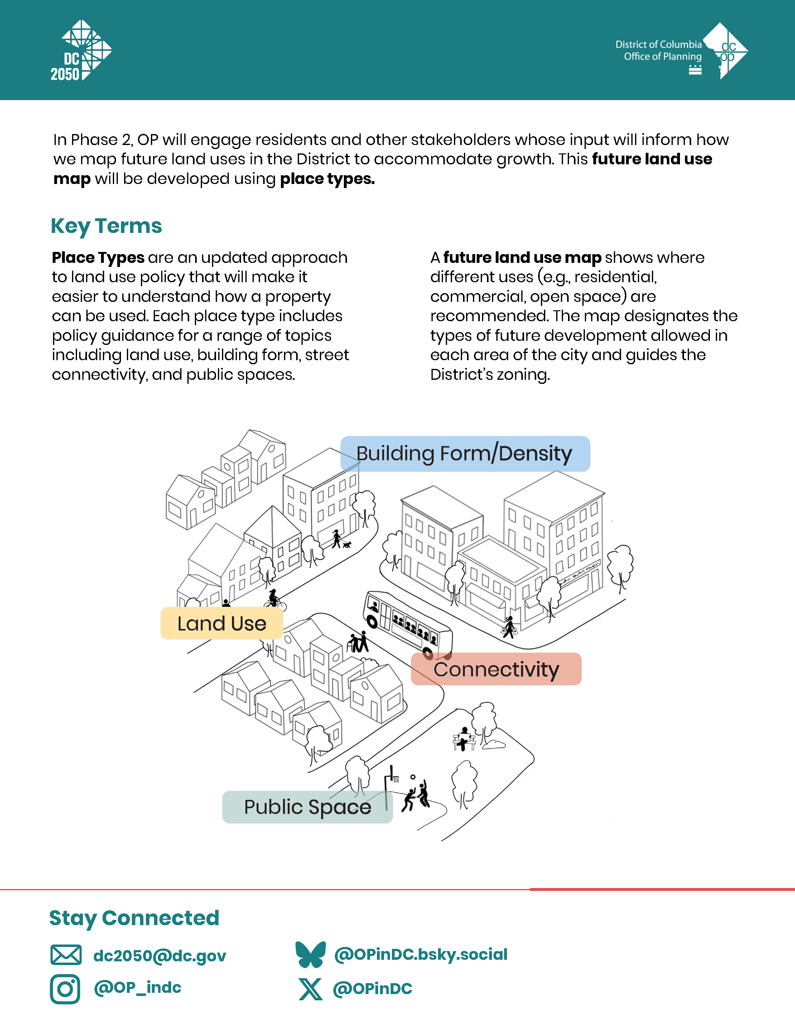
The DC Office of Planning (OP) is working on DC 2050, the rewrite of DC’s Comprehensive Plan, that will guide how the city grows and develops. With DC 2050, OP aims to “align land use policies and investments to make the District more equitable, affordable, and resilient.”
OP is currently in Phase 2 of the process. The agency is giving residents an opportunity to explore the city’s land use policy and let District officials know how and where you think the city should grow.
It is worth taking a few minutes to look at OP’s initial thinking about how to accommodate growth in the city (e.g., downtown, near Metrorail stations, and/or along bus priority corridors).
In addition, residents are invited to join musicians for a songwriting program, “Imagine Our City’s Next 250 Years,” at Woodridge Library on January 31 at 12pm. The DC 2050 team will be on hand to chat about the Comp Plan process.
Please join us on Wednesday, Jan. 28th at 6:45 PM for ANC 5A’s Monthly Meeting
The Commissioners will be meeting in-person. On Zoom, Commissioners will be let into the meeting room first. Once they are all present, the residents will be let in.
Join us In-Person: University of D.C Lamond Riggs Campus 5171 S Dakota Ave NE, Washington, DC 20017
Ward 5 Councilmember Zachary Parker recently introduced Bill no. 26-415 that would symbolically designate the 4800 block of 7th Street, N.E. in North Michigan Park as Joseph Bowser Way after Mayor Muriel Bowser’s father. The DC Council held a hearing on the bill on January 13, 2026. Written testimony will be accepted until January 27.
On the consent calendar for ANC 4B’s public meeting on January 26, 2026, is a resolution to support a zone designation change to the Future Land Use Map (FLUM) for 6000 Chillum Place NE from PDR-1 to Mixed-Use Industrial. The property is currently occupied by Martin Wiegand Lumber Wholesale.
The owners of Martin Wiegand Lumber Wholesale Inc, represented by Chandler Wiegand, have resided within ANC 4B for (insert number of years) on land presently designated as PDR-1, or Production, Distribution and Repair-1, at 6000 Chillum Place NE, pursuant to the District of Columbia’s Zoning Regulations.
The owners of the aforemementioned property have engaged in proactive, meaningful community outreach and have engaged with Commissioners within ANC 4B to ensure that as the city works toward DC 2050 – the District of Columbia’s Comprehensive Plan – that 6000 Chillum Place NE will be able to evolve with and support the city’s plans for the future. To that end, ANC 4B supports their request and application that SSL 3379 0821 be successfully reclassified from PDR-1 to Mixed-Use Industrial, which is a new proposed designation under consideration in the 2050 Comprehensive Plan. This application to be reclassified is in light of the Future Land Use Map under consideration in the DC 2050 Comprehensive Plan.
6000 Chillum Place NE presently resides within a narrow PDR zone; however, it is broadly surrounded by residentially zoned areas (specifically R-2), and is within 0.2 tenths of a mile of a MU-3A zone and within 300 feet of a public charter school. The Commission also takes note of the following changes to the area:
WHEREAS, encroaching uses that are not compatible with the current use, substantial and material changes in the character of the surrounding land including the introduction of public charter schools within industrial zones have fundamentally altered the functional landscape of the area; and
WHEREAS, the property driveway entrance is directly across from a public charter school and residentially zoned neighborhood; and
WHEREAS, the immediate vicinity of the property now reflects mixed urban uses, characterized by increased pedestrian activity and increased automotive traffic incompatible with current heavy truck use giving further evidence of the transition from historically industrial activity toward community-serving and mixed-use development; and
WHEREAS, the owners of 6000 Chillum Place NE have spent considerable time and effort seeking consideration of the site for distribution use but has been declined by both private companies and government agencies (DMV, DPW, DGS) in part due to the liability of high pedestrian and automotive traffic associated with the school directly across from the property and one block from the property. Additionally, pursuant to District of Columbia law, the property is prohibited from being utilized for alcohol production or cannabis cultivation, processing, or manufacturing due to its proximity—within 300 feet—to a school and—within 400 feet—to a church, without a special variant thereby creating a hardship by precluding viable industrial activities and limiting feasible by-right industrial uses; and
WHEREAS, the Advisory Neighborhood Commission finds that such constraints, when considered alongside the citywide demand for housing, community amenities, and flexible-use facilities, render a change to Mixed-Use Industrial zoning both reasonable and necessary; and
WHEREAS, the property is in close proximity to the public transportation, including two metro stations within one mile of the property (Fort Totten to the south and Takoma to the north), established bus routes and a dedicated bicycle trail (Metropolitan Branch Trail) connecting the property with two Metrorail stations located less than one mile from the site, support a land-use pattern more consistent with Mixed-Use Industrial zoning; and
WHEREAS, the change to Mixed Use Industrial is consistent with the goals outlined in the DC 2050 Comprehensive Plan to encourage transit-oriented, mixed-use development in appropriate locations; and
WHEREAS, a change to Mixed Use Industrial zoning would contribute to the economic vitality of the neighborhood by allowing for the creation of jobs and opportunity to create needed housing and reuse an underutilized industrial site; and WHEREAS, the Commission further finds that establishing Mixed-Use Industrial zoning at this location will strengthen the neighborhood’s long-term resilience by enabling a broader range of compatible uses and ensuring that the property may adapt to future, presently unforeseeable, community needs.
RESOLVED;
The Commission urges the Office of Planning and Zoning Commission to give consideration to this resolution in accordance with the rewrite of the DC 2050 District of Columbia Comprehensive Plan; and
ANC 4B hereby expresses its strong and unequivocal support for the change in the Future Land Use Map of the subject property from PDR-1 to Mixed-Use Industrial in the DC 2050 revision of the Comprehensive Plan; and
The Commission believes such a change is consistent with current neighborhood conditions, aligns with established planning objectives, and advances the public interest of Ward 4 and the District of Columbia.
Ward 5 Councilmember Zachary Parker invites residents to join his next Quarterly Public Safety Call on Tuesday, January 27, 2026, at 3:00 p.m.
Topics:
Helping neighbors experiencing mental health or substance abuse crises
Fire safety
Recent crime statistics and incidents
Guests:
MPD
DC Fire and EMS to cover recent fires
Department of Behavioral Health to discuss mental health crises and how to help neighbors out in the cold
HIPS to share about their harm reduction efforts in Ward 5.
Register to receive the meeting link at ward5.us/publicsafetycall. The meeting will be livestreamed on CM Parker’s YouTube channel. It will be recorded, and slides will be shared afterwards.
For voice-only participation on a telephone, dial +13017158592, 81406325863#
Meeting ID: 814 0632 5863
Call to Order & Roll Call
Administrative Items
Instructions for participation in virtual and in-person meetings
Consideration and approval of January 2026 Regular Public Meeting Agenda
Proposed 2026 meeting calendar
Approval of November 2025 Regular Public Meeting Minutes
Treasurer’s Report
Election of Officers
Commissioner Updates
Community Concerns
Please use the “Raise Hand” button via Zoom or *9 via telephone to speak.
The Commission will provide details regarding how to present community concerns at the start of the virtual meeting. This is the time for questions or statements from members of the public about issues on the agenda or other areas of concern. Please limit your statement or question to one minute. You may contact members of the Commission before and after Commission meetings.
Reports
Barbara Rogers, District Director, Ward 4 Councilmember Janeese Lewis-George (3 minutes)
T. Michelle Colson, Ward 4 State Board of Education Representative (3 minutes)
Leticia Acosta, Mayor’s Office on Community Relations and Services (3 minutes)
4B Community Safety & Support Committee (2 minutes)
Presentations
Kelly Whittier, Director of Public Affairs – Humane Rescue Alliance
Lauren Forbes, Manager, DC Region– Capital Area Food Bank
Shauna Gordon-McKeon, member of Ward 4 Leadership Team, Free DC
Michelle Hammonds, Director, Office of Financial Empowerment and Education – Department of Insurance, Securities and Banking (DISB)
Oversight hearings provide a good opportunity to let the Council know what District agencies are doing well and how they can improve. It is a good first step in advocating for budget funding. Visit the Council’s website to see tips about providing testimony.
Worth taking some time to let those with the power to do something know about issues that residents have.
We have a new mayor’s office liaison (MOCR) for Ward 5. Lacy Davis recently joined the Ward 5 MOCR team with Christian Starghill.
MOCRS are community outreach specialists typically seen at community meetings. They are helpful when residents need assistance with District agencies. Some issues can be resolved through submission of 311 service requests, so it is helpful to submit a 311 request first and then follow up with the MOCRs if the issue is not resolved satisfactorily. MOCRS can work long hours and in my experience they are usually quite patient and pleasant to work with.
Below is contact information for the Ward 4 and Ward 5 MOCRS.
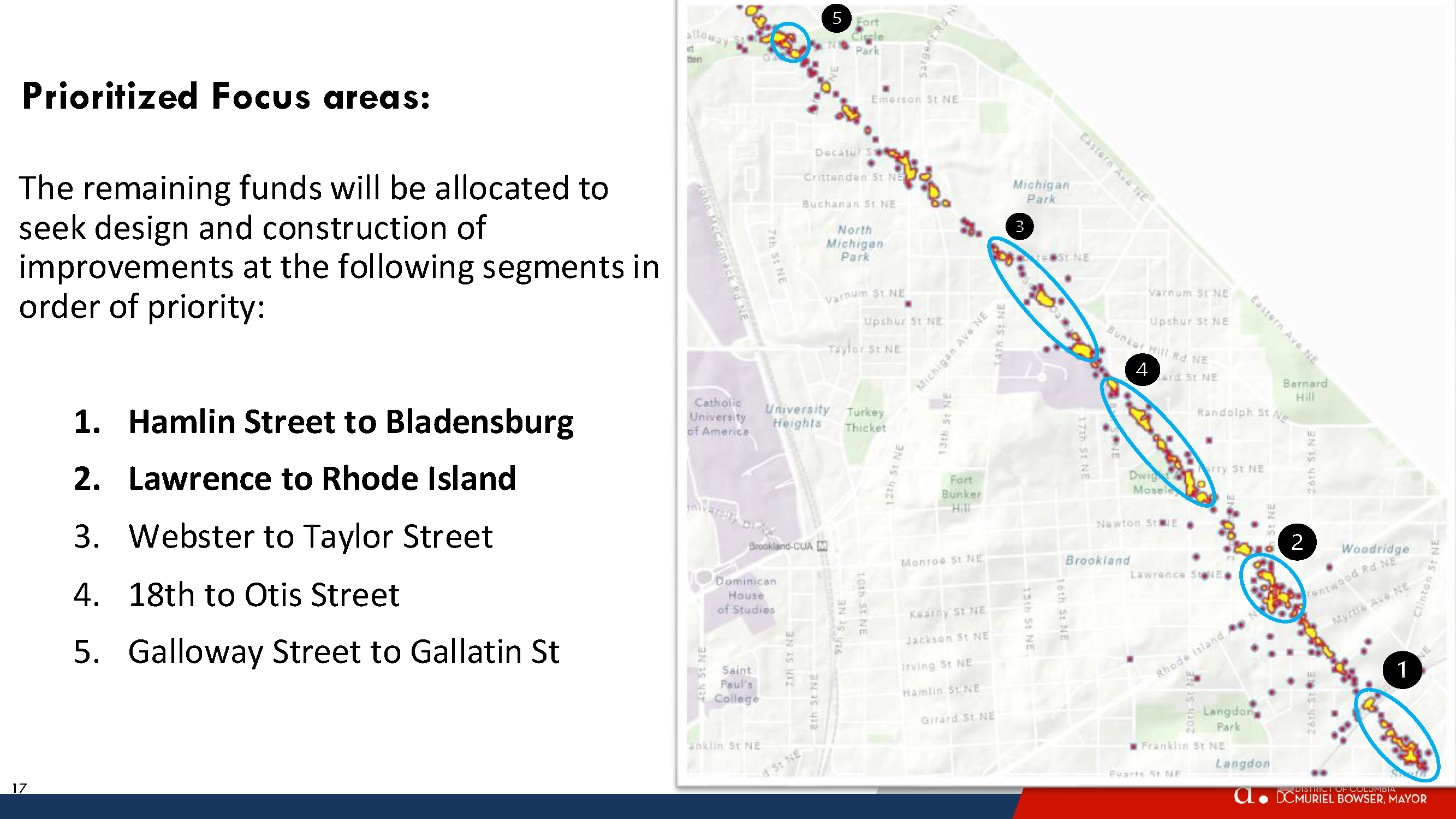
Spot Treatment Locations from Highest to Lowest priority
Hamlin Street to Bladensburg
Lawrence to Rhode Island
Webster to Taylor Street
18th to Otis Street
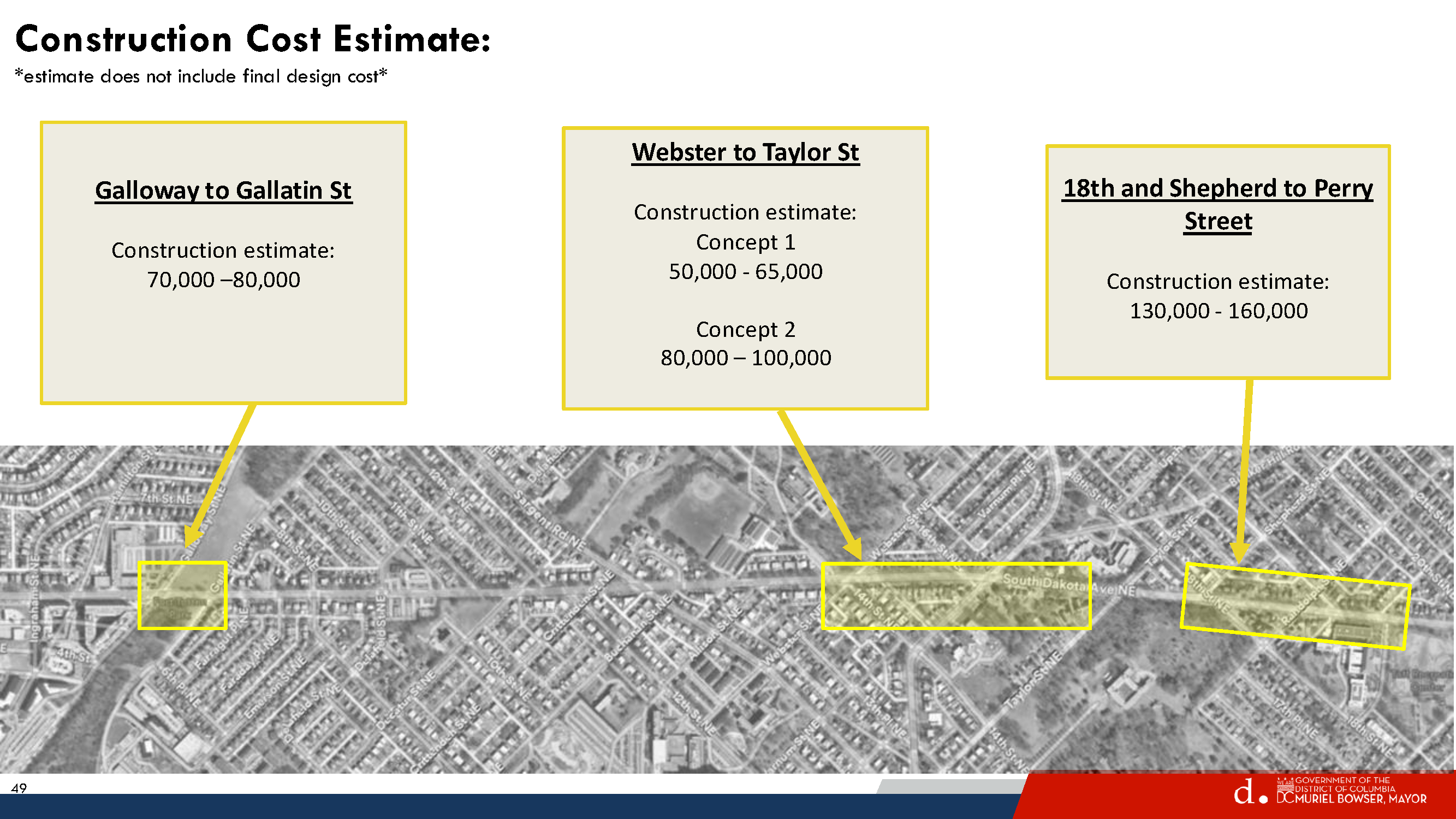
Galloway Street to Gallatin St
Galloway-Gallatin is the only location selected for spot treatment in this neck of the woods. DDOT did not plan to address anything on the northern end, but then Galloway received the most comments and Riggs Road received the second highest number of comments. So DDOT decided to put Galloway-Gallatin at the bottom of the priority list. Everyone, including DDOT, knows that Riggs is a problem but they say that addressing Riggs & South Dakota would be a very capital intensive project that would need support from the Ward 4 councilmember.
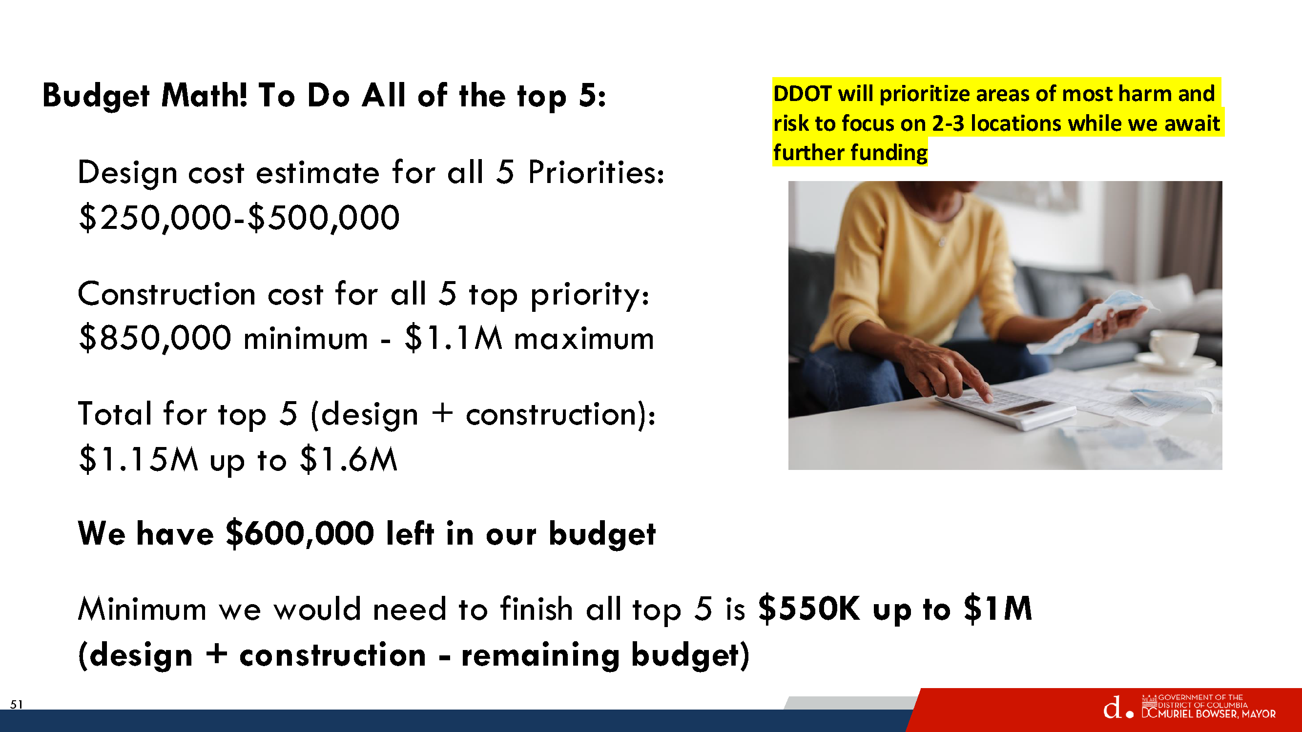
In any case, DDOT has about $600,000 remaining in the South Dakota Avenue corridor project budget, which is enough for just the top one or two priority areas. But Councilmember Zachary Parker’s office seems confident that they can get more money to do all five priority areas if residents really want them to.
So let’s pretend that DDOT will get to the northern end and take a look at what they propose for Galloway-Gallatin.
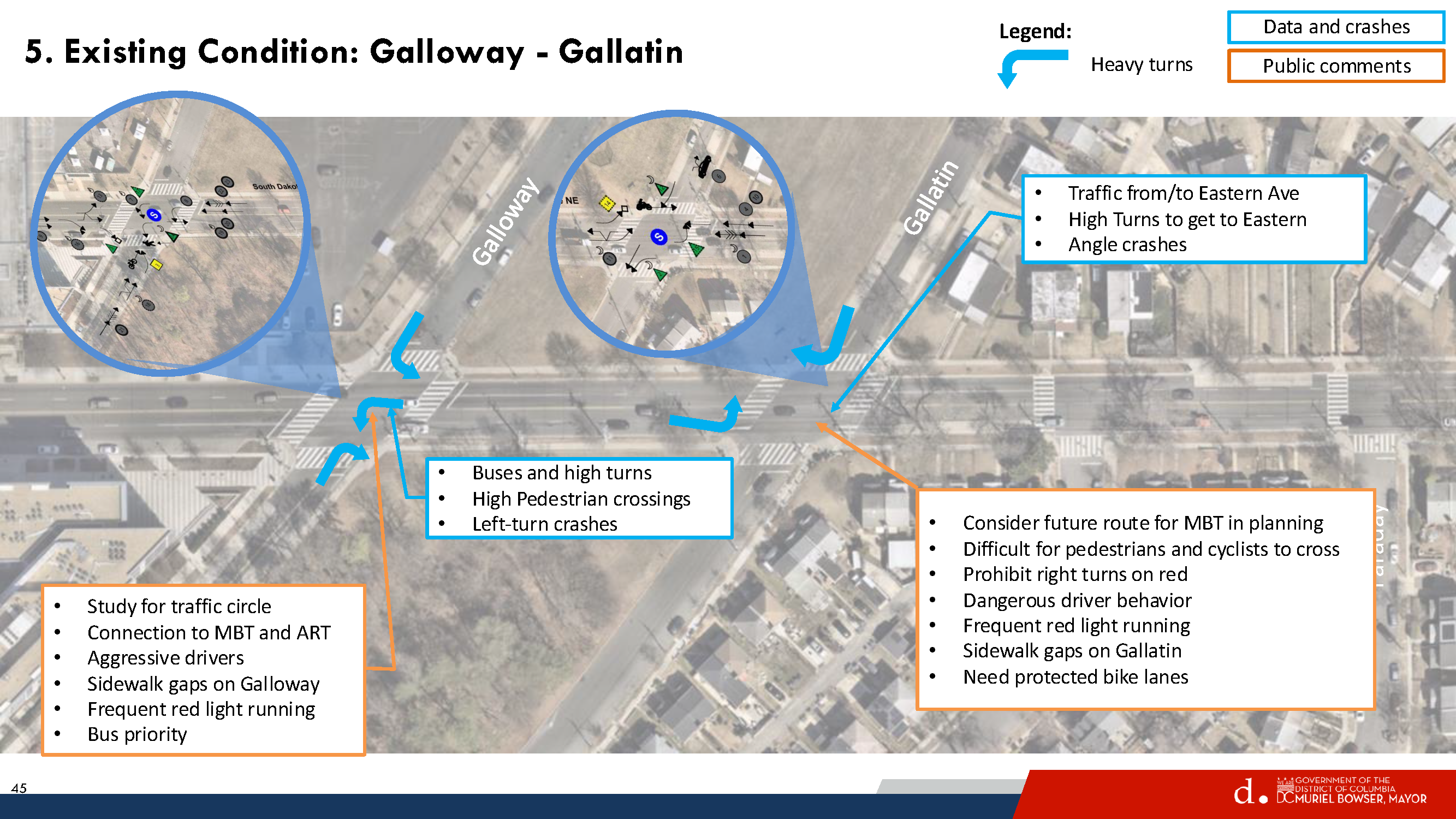
Existing Conditions Galloway-Gallatin
Residents are familiar with existing problems at South Dakota/Galloway and at South Dakota/Gallatin. Galloway gets a lot of traffic. It leads to the Fort Totten station and the Metropolitan Branch Trail, so lots of cars, buses, pedestrians, and people on bikes. The station is a major bus transfer point and lots of students use the station to get to nearby UDC and charter schools or to get on buses to go to schools outside the neighborhood. Gallatin sees less traffic than Galloway, but still gets a fair amount. And Gallatin is envisioned as a future connection to bike trails in Prince George’s County.
Looking at the existing conditions described by DDOT above, note that there is no intention of putting a traffic circle at either Galloway or Gallatin. That was a comment submitted by a resident during the early stages of the project.
Proposed Concept – Gallatin
For Gallatin, DDOT would consider a few things:
Centerline hardening southbound South Dakota to slow down turns
“Stop for Pedestrian while Turning” signs
Daylighting markings on all four corners of Gallatin to improve visibility of crossing pedestrians
Yellow frame around traffic lights so that they are easier to see
This all seems fine enough and would not interfere with potential bike facilities in the future.
Proposed Concept – Galloway
For Galloway Street, DDOT would consider doing a few things:
Northbound South Dakota Avenue
Dedicated left turn lane
Short Median in northbound travel lane would provide safe space for people in middle of crossing, ensure that drivers turn left at Galloway and do not proceed straight, and reduce the number of through lanes in just that one spot.
Center lane hardening
Southbound South Dakota Avenue
Lane markings
Eastbound Galloway Street
Two eastbound travel lanes so that there is a left turn lane for drivers to head northbound on South Dakota Avenue or proceed straight on Galloway and a dedicated right turn lane.
Westbound Galloway Street
One travel lane westbound
Daylighting markings east and west of South Dakota
This post is way too long so TL;DR here – I do not think what is proposed for Galloway makes sense, and I am curious what others think.
The thing that jumped out to me immediately is that the proposal states that DDOT would talk to Metro about removing the eastbound bus stop at Galloway & South Dakota in order to make two eastbound travel lanes on Galloway. I confirmed with DDOT that they were referring to the eastbound stop. In fact, Metro removed that eastbound bus stop during the bus network redesign but that got overlooked by DDOT.
That means the westbound stop on Galloway would remain. There are a lot of cars and buses that make that left turn onto Galloway. Currently, when buses make the turn onto Galloway and stop at that westbound stop (it is used a fair amount), cars are able to go around the bus. If DDOT makes two eastbound travel lanes and one westbound lane, I do not think there will be enough space for cars to go around the stopped bus and that would leave cars hanging out in the intersection trying to make the left turn. That would not be good.
DDOT said maybe they could move the stop further west or create a diversion space around the bus or something. I do not see where else the stop could go that would not create the same problem or become useless given that it is the last stop before the Metro station and moving it closer and closer to the station would eventually make it useless.
Also, I think I can safely say that the buses would not be able to make that turn onto Galloway if the stop bar is at the crosswalk. Moving the stop bar back could provide a better turning radius but then fewer vehicles would get through the intersection to turn left or go straight ahead.
With respect to the dedicated turn lanes westbound Galloway, I do not know that it makes sense to have vehicles traveling straight on Galloway sitting behind vehicles waiting to turn left.
I am also not sure about the treatment for South Dakota Avenue with the short refuge median there.
All of this to say, I am not so sure that the proposal for the Galloway-South Dakota travel lanes make a lot of sense. But I am not an engineer and I have not seen a traffic analysis, so I don’t know, maybe this all could make sense.
Things that I think would make sense:
More time for pedestrians to cross South Dakota at Galloway
Centerline hardening (though I suspect the buses will just run over it)
Daylighting on Galloway east of South Dakota on both sides of the street. Bulbouts here are actually included in UDC’s 2023-2033 Lamond-Riggs campus plan (which is not really moving forward because apparently there is no money or something). UDC’s enrollment at the Lamond-Riggs campus has grown tremendously (which is why they really need funding to proceed with their campus plan, so DC Council really should give them the money to do it!!). Between campus visitors and the youth sports teams that practice on the field across the street from the campus, lots of cars end up being parked right up to the intersection often enough.
I like the idea of dedicated left turn lanes because it is true that waiting for buses/cars to turn left backs up traffic and makes people impatient and they end up running the light regularly enough. But I just do not know that this concept is the way to do it unless maybe they removed the parking lane on Galloway west of South Dakota, which I am reluctant to even type out because I can just see heads exploding. Lots of parents drive to the daycare on Galloway so I can certainly see why people would want some curbside space to drop off and pick up the kiddos.
Also, a 10-foot multi-use path is supposed to be installed on the south side of Galloway between South Dakota and 4th Street, with construction currently anticipated in 2026-2027. This is one of those (federal) projects that keeps getting pushed back year after year for all sorts of reasons. If this does proceed as planned, it might be useful to see how travel patterns for pedestrians and people on bikes change.
None of this will likely do much to slow down the excessive speeding on South Dakota, which was supposed to be the whole point of the corridor project. But we abandoned that goal before we really got started so.
These are just my thoughts. DDOT will not do anything at Galloway-Gallatin unless residents really want them to and ask Councilmember Parker’s office to identify funding to get it done. The cost for Galloway-Gallatin is not that much (roughly $70,000-80,000), so people need to decide what they want to happen or not happen.