
Yesterday, Metro’s board approved the Better Bus network redesign. Metro will begin implementing the plan in summer 2025. The Better Bus Resource page contains route information/maps by state and other handy documents.
Bus Stop Consolidation
View Metro’s bus stop consolidation report (November 2024).
In the redesign, Metro continues to propose eliminating several neighborhood bus stops, as discussed in this post. But Metro now proposes to retain the stop at Chillum Place & Eastern Avenue NE that was originally slated for removal.
| Bus Stop | Route | Plan |
| South Dakota Ave & 8th St NE | 80 | Remove |
| Galloway St & South Dakota Ave NE | 80, E2, F6 | Remove |
| Riggs Rd & Rock Creek Church NE | 60, 64, E4, K2, K6 | Remove |
| Riggs Rd & Blair Rd NE | 60, 64, E4, K2, K6 | Remove |
| Chillum Pl & Eastern Ave NE | E4 | Retain |
| New Hampshire Ave & Longfellow St NE | K6 | Remove |
| Nicholson St & Riggs Rd NE | E4 | Remove |
| New Hampshire Ave & Oneida St NE | K6 | Remove |
| New Hampshire Ave & Quackenbos St NE | K6 | Remove |
I am personally annoyed about the planned removal of the stop at South Dakota and Galloway. Riggs Park residents will have to either walk up the steep dirt hill to the stop at Galloway & 4th or walk to the stop at South Dakota & Farragut and stand at a stop on a narrow sidewalk without a bench or shelter. Alas.
(Yesterday, Councilmember Zachary Parker sent a letter to Metro leadership with some initial concerns about some of the proposed stop removals in Ward 5. The letter mentions the stops at Riggs/Rock Creek Church and Riggs/Blair).
New Naming Convention
Metro is moving forward with the new naming convention. Routes are named based on the following criteria:
- The first character represents general area:
- D or C (District of Columbia, with D generally corresponding
to routes serving Downtown and C with Crosstown routes) - M (Montgomery)
- P (Prince George’s)
- A (Arlington and Alexandria)
- F (Fairfax County, City of Fairfax, and Falls Church)
- D or C (District of Columbia, with D generally corresponding
- The second character represents a number that clusters
routes along the same corridor or in the same neighborhood - The third character distinguishes it from other routes in that
cluster; an X represents limited-stop service
Neighborhood Bus Route Crosswalk: Existing Route –> Approximate Proposed Route
E2 –> C71 Fort Totten – Union Station via Ivy City
E4 –> C81 Sibley Hospital – Fort Totten
80 –> D30 Fort Totten – Federal Triangle via North Capitol Street
64 –> D44 Fort Totten – Federal Triangle via 11 Street NW
K2 –> C77 Takoma – Fort Totten
K6, K9 –> M60 White Oak Medical Center – Fort Totten via New Hampshire Avenue
K6, K9 –> M6X White Oak FDA – Fort Totten
R1, R2 –> P15 Riggs Road – Adelphi via Riggs Road)
R1, R2 –> P16 White Oak Medical Center – Fort Totten via Riggs Road
F6 –> P32 Fort Totten – Greenbelt
F6 –> P35 Fort Totten – New Carrollton
K2 –> P42 Takoma – New Carrollton
Route Changes
Neighbor Gavin and I took a quick look at some of the final route changes for the neighborhood. A few differ from what Metro proposed earlier this year. Entirely possible missed some things or got something wrong. Metro made some tweaks to the Maryland lines that serve Fort Totten station, but I did not look super closely at them.
Metro prepared a handy response summary providing a bit of rationale for some of their decisions.
Service on Riggs Road/Chillum Place/Nicholson Street/Eastern Avenue NE (E2 –>C71)


Metro is moving forward with chopping the upper NE/NW route E4 crosstown loop to Riggs Park. Seems planners could not quite figure out what to do about service between Fort Totten station and Eastern Avenue NE, despite the several comments asking them to keep at least one crosstown loop to Riggs Park so that people can actually travel crosstown and get to locations like grocery stores, schools, library, and their homes without having to transfer buses.
Previously Metro proposed adding the eastern tail of the current loop to a route that would go out to Maryland. In the final plan, Metro goes in a completely different direction by putting the eastern tail onto route C71, a route most similar to existing route E2 that runs between Fort Totten and Union Station via Ivy City. Looks like the route will no longer travel down Gallatin Street NE. Instead, the route will service South Dakota, Riggs, Chillum Place, Eastern, and Nicholson.
Service 7 days/week. Frequency 20-30 weekdays; 30 minutes on weekends.
Crosstown Route (E4 –>C81)

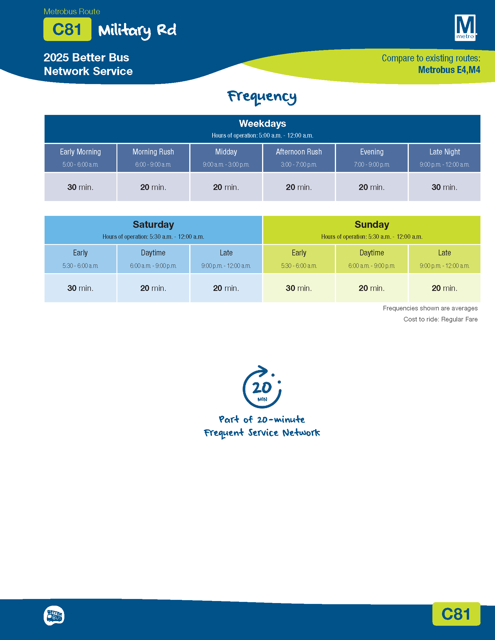
There will be just one upper NE/NW crosstown loop serving Fort Totten station. Route C81 will serve locations between Fort Totten station and Sibley Hospital. There will no longer be direct crosstown service to Friendship Heights station.
Service 7 days/week. Frequency of 20 minutes most of the time.
Lamond Service (K2 –> C77)
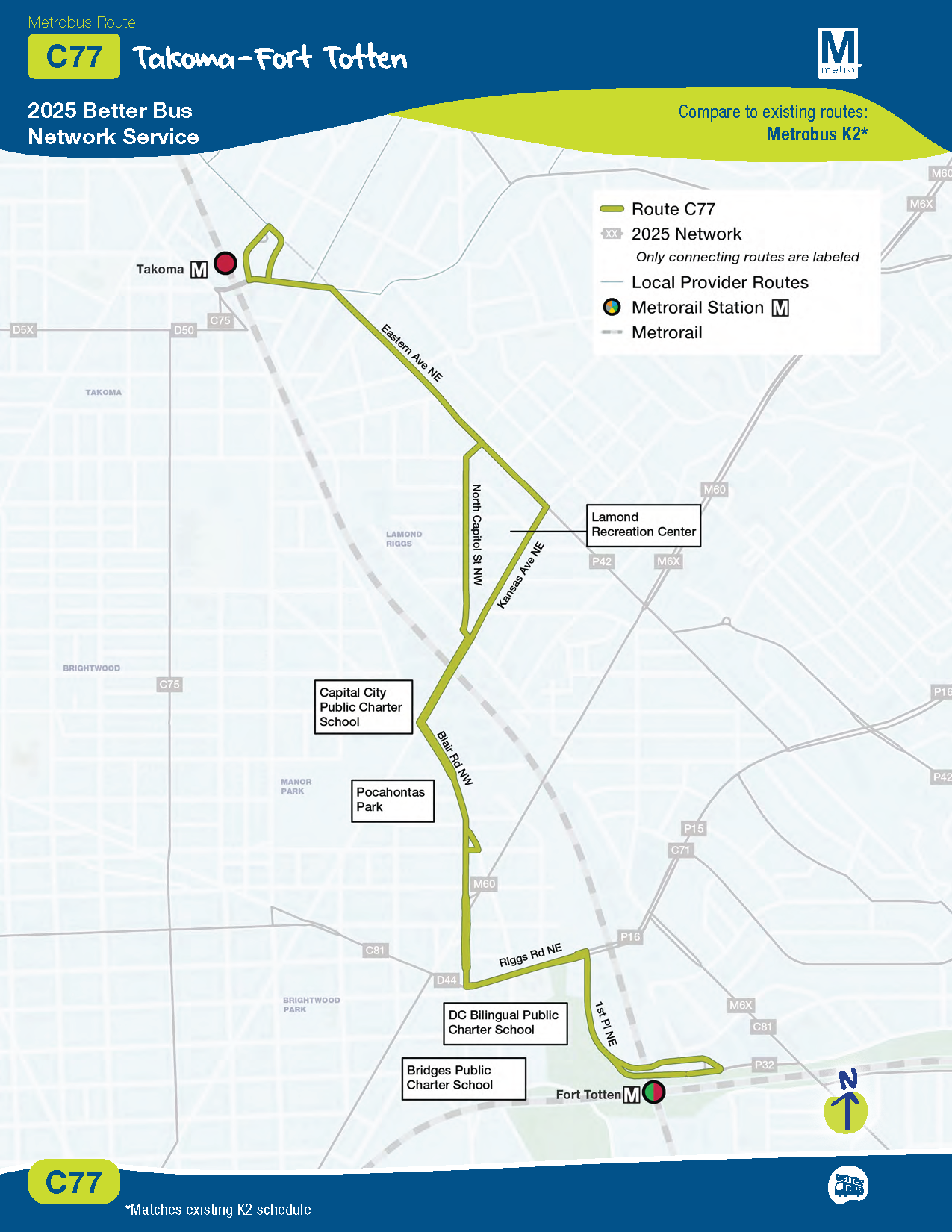
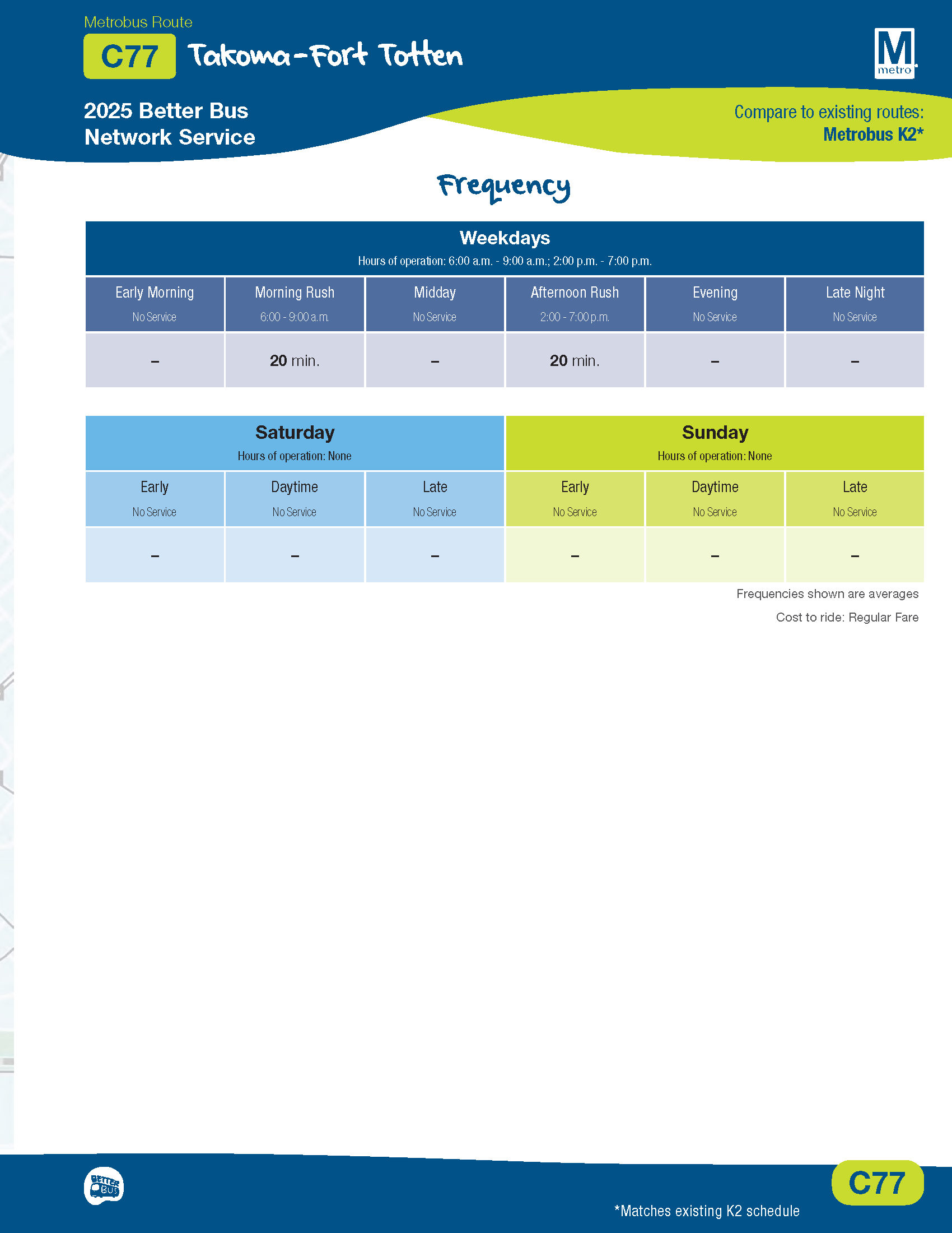
Metro previously proposed eliminating route K2 between Takoma and Fort Totten station. The final plan adopts new route C77, which will be similar to existing route K2.
Route C77 will run only on weekdays during rush hour. Frequency of 20 minutes.
Some Thoughts
This network redesign was a hefty task. I appreciate the level of outreach that Metro conducted and the various online tools developed to help make sense of all of the proposed changes and provide feedback. I also appreciated the comment/response summary documents. It is clear how much work went into collecting and analyzing all of the feedback and coming up with a final plan designed to meet several objectives. So while I would like to think of the bus as my personal chauffeur, I get that there have to be adjustments and tradeoffs.
Hopefully sooner rather than later, Metro will be able to enjoy a more sensible funding structure, and we can get a visionary network that the city and region deserve. On the Metrorail side, looking forward to the purple line in opening in a few years. Also, Metro is talking publicly about possibly restoring some yellow service to Fort Totten station.
In the meantime, Metro will be preparing to implement the bus network changes in summer 2025.

I am confused. Does this mean that the Riggs Park soon to be ? will still come down Chillum Place NE? I live in the 5200 block and have been riding this bus since the 70s. I am 66 now and walking ten blocks to Fort Totten will be a stretch.
Hi, there will still be service along Chillum Place, just not as part of the crosstown route. Look at the map for route C71 for service between Fort Totten & Union Station. It’s a little hard to tell exactly how the bus will travel in this part of the neighborhood. I think you would still be able to pick up the bus at Chillum Pl/Eastern Ave NE to get to Fort Totten station since they’re retaining that stop, but I can’t say for sure.
Ok but I live on Chillum Place NE. Bus stop is 4 houses from where I live. Very convenient for me but we have senior citizens and elementary school children who use this bus to get to LaSalle and DC Bilingual School on Righs Road. So there has to be a better solution
You can email your thoughts to CM Parker at ward5contact@dccouncil.gov.
Thanks for this summary. I attended one meeting metro had with councilwoman JLG. They changed a few things from their initial proposal which is good. A lot of people were concerned about them removing services that students used and changing to 20 to 30 min wait times. I also advocated for them not to entirely remove k2 as it would have left a large area in Lamond with no service. Alas 🤷♀️
1)The new names are STUPID. needs to stop messing with route names and worry about drunk bus drivers and train drivers.
2) So now e4 will run from Ft T to Sibley Hospital? It is going beyond FH? That is a long route. Reminds me of when 70 use to run SS to Half and O St SW, a 2 hour bus ride!
Leave the bus routes names. This is not better.