January 30, 2019
6:45 pm
UDC-CC Backus (5171 South Dakota Avenue NE)
Agenda:
1. Providence Hospital Update
2. 1 Hawaii Avenue NE Project Update
3. Public Safety Issues Crossing South Dakota Ave

January 30, 2019
6:45 pm
UDC-CC Backus (5171 South Dakota Avenue NE)
Agenda:
1. Providence Hospital Update
2. 1 Hawaii Avenue NE Project Update
3. Public Safety Issues Crossing South Dakota Ave
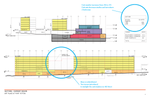
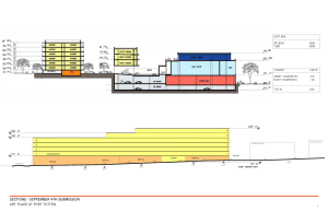
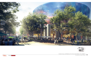
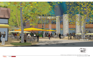
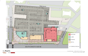
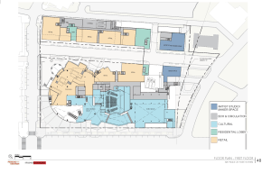
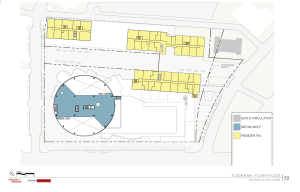
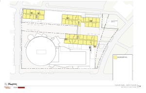
Back in September 2018, the Cafritz Foundation released big plans for the second phase of Art Place at Fort Totten, also known as the FEZ at Art Place or Block B in the plans. In December 2018, the developer announced that Meow Wolf would operate part of the family entertainment zone. On January 25, 2019, the developer filed updated plans to respond to issues raised by the Office of Planning (OP) and the District Department of Transportation (DDOT) when the project was recommended to be set down for a hearing. Some of the changes/clarifications include:
The developer states some of these changes were driven by Meow Wolf and the grocery store operator. On that note, the developer states it is very close to announcing the grocery store, as in the next couple of weeks. As this submission and also residents have noted, the city is full of free museums and other programming. Therefore, this family entertainment zone needs to offer something unique. The developers believe some of these changes will help to accomplish that goal.
It’s worth looking at their prehearing statement. To view the full book submitted with the prehearing sttement, look up case number 06-10D on the Zoning Commission’s website. A hearing is scheduled for April 4, 2019. Stay tuned for community meetings on these updates before then.
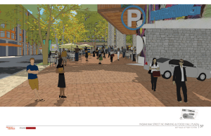
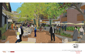
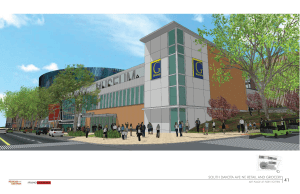
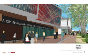
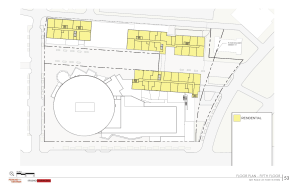
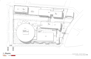
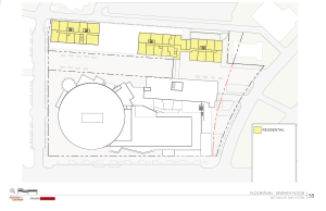
Proposed residential changes

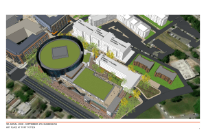
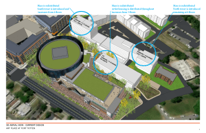
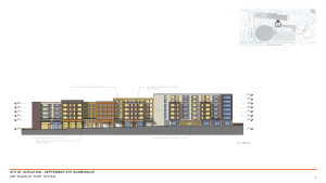
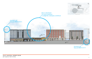
Renderings


A couple of updates on the first phase of Art Place at Fort Totten. T-Mobile is open at Art Place, located at 5210 South Dakota Avenue NE. Store hours are Monday through Friday 9:00 am-8:00 pm; Saturday 10:00 am-7:00 pm; and Sunday 12:00 pm-6:00 pm.
I have also gotten a lot of questions about the gym and when it will open. As noted individually to some readers, there really is not an update to provide since our last one. The developer is in late-stage negotiations with an operator. No word on when it will open. Sorry I cannot be the bearer of better news. I know residents are anxious for a neighborhood gym.
Guest post by David Kosub
In no particular order, these letters of support come voluntarily from members of the Riggs Park community. Their goal is encouraging Advisory Neighborhood Commission (ANC) 5A to endorse a resolution requesting the District Department of Transportation (DDOT) to strengthen pedestrian safety crossing South Dakota Avenue NE.
As some requested anonymity, I decided to respect everybody’s privacy and remove all names and other identifying information from this public post. That said, their words still demonstrate passion. Concerns are vividly expressed. Personal experiences are relived. Actions taken are retold. And, most importantly, you will see how much they care for their community.
A resolution and our concerns will be presented at the January 30, 2019, ANC 5A meeting at 6:45 p.m. at UDC-CC Backus, so please attend if your schedule permits. If you would like your voice included as part of this initiative, please add your thoughts in the Comments section below.
———————–
Letter #1
I am writing to voice support for the resolution brought forth by David Kosub. My husband and I moved to the neighborhood two years ago and began voicing concerns related to pedestrian safety and well-being crossing South Dakota Avenue NE at Ingraham Street NE and Jefferson Street NE (right by our public library) since that time.
We have collectively submitted dozens of 311 requests asking for improvements to safety in that area – ranging from white striping to signage to HAWK lights and even a traffic light. Each request is dutifully closed without any action taken. MPD officers themselves speed down South Dakota Avenue and do not stop at crosswalks. I’ve witnessed it many times. Every single time you cross, you literally take your life into your hands.
These two crosswalks are our main method of walking to and from the Metro Transit station each day. And it’s not just ours – it’s the pathway taken by nearly anyone in the neighborhood who travels via Metro – including young children, senior residents, families and even individuals who have disabilities or impairments. We’ve witnessed accidents (including a young pedestrian getting hit) which we’ve reported and near accidents personally. Better signage is seen throughout the South Dakota Avenue corridor and it’s incomprehensible at how much push back and delays we have faced to get the same signage installed at those two crossings.
As mentioned in the draft resolution, such concerns are likely to amplify as more residents move into nearby apartment buildings, development continues, commercial retail opens, Main Street aesthetic improvements are made, our local branch library reconstruction ramps up, and more citizens are encouraged to walk throughout the neighborhood (and/or come to visit the neighborhood).
The lack of safety precautions and appropriate lighting make this intersection deadly and it should not take a death for DC departments including the Mayors office, DDOT and MPD to work together to fix this problem. But from this lack of action and collaboration it feels as if that’s what these departments are waiting for. This lack of action is terrible customer service and very inconsistent with DC’s Vision Zero goals. I know that District officials can do better and offer a better response than what has been provided thus far. We’ve been waiting nearly two years and that’s long enough – I urge you to take action now.
———————–
Letter #2
I am very familiar with the situation at South Dakota and Ingraham. I walk to Metro every weekday from my house on Kennedy St., crossing South Dakota Avenue at the area under discussion. I walk back each weekday evening. As I have watched the Modern arise over the past few years, I have often wondered why the traffic signal remained at Hamilton and was not relocated to Ingraham.
From my personal experience, I do not have a problem crossing South Dakota in the morning. It is light out and there is often a substantial break in traffic to cross safely. Cars often slow down or stop for me. However, coming home in the evening is different. Northbound traffic seems to move much faster than the 25-mph limit. (I suppose people want to get home.) I also feel that I am not well seen in the evening.
I urge DDOT to reopen their exploration of this series of intersections and attempt to make it safer before something bad happens to a pedestrian.
———————–
Letter #3
We’re new homeowners in Lamond-Riggs, and proximity to metro and walkability were priorities when considering where to live. While we love being within walking distance of the Fort Totten metro, we’ve been dismayed at how dangerous it is to cross South Dakota Avenue to get to and from work each day.
Cars treat the stretch of South Dakota between Gallatin Street and Riggs Road like a raceway, and we sometimes have to step into traffic and wildly wave our arms at oncoming traffic in order to get them to stop. We’ve seen older residents stuck on the corner waiting for a break in traffic; cars that speed up because they’re coming off the light, even as people are already in the crosswalk; and drivers mockingly waving at people in the crosswalk as they speed through. It’s only a matter of time before someone is seriously hurt.
At a recent meeting with a DDOT representative, we were upset to hear that they did not know how long it would take to get signage at the intersection of South Dakota and Ingraham Street — the main access point to metro — and that there was no plan by DDOT to deploy the kind of infrastructure we’ve seen in other neighborhoods (traffic calming measures, flashing lights, or a traffic light, for instance).
If the city is serious about redeveloping Fort Totten, it must prioritize pedestrian access and safety, especially along such a primary access point to metro across a busy road.
———————–
Letter #4
I am writing this letter to express my strong support of efforts to increase pedestrian safety at the intersections of South Dakota Avenue and Jefferson Street NE and of South Dakota Avenue and Ingraham Street NE. I moved to Jefferson Street NE in September 2018 with my husband, and I use the crosswalk at South Dakota and Jefferson every weekday morning and evening to get to and from Ft. Totten Metro Station.
My experience with the crosswalk at Jefferson has been frustrating and frightening, because the vast, vast majority of drivers ignore pedestrian right of way at these intersections-even when I’m in the middle of a crosswalk. On average, I estimate that a vehicle only stops to let me start to cross the road once every 2 weeks. Every other time I’m at the intersection I have to wait for a break in traffic to be able to cross the street. I used to enter the crosswalk when the road was clear for the first section, so that I didn’t have to wait as long, but about once every week a driver would still drive through the crosswalk right in front of me without stopping. Earlier this month a driver doing this was also speeding, and I narrowly avoided him killing me.
Safe pedestrian access to the Metro station is too important to ignore. Please help.
———————–
Letter #5
I have lived on Ingraham Street NE for eight years and have observed one measure taken to address pedestrian safety since I have moved into the neighborhood – the addition of crosswalk painted lines to cross South Dakota Avenue. I walk and drive on South Dakota Avenue NE multiple times a day and worry about the safety of those crossing the street, particularly during rush hour and night times. That intersection is also not particularly well lit, making it difficult for drivers to see pedestrians waiting to cross.
As a frequent driver, I have noticed this firsthand – I will stop at the crosswalk to let a pedestrian cross only to have 10 cars drive past me instead of stopping.
Please help us keep my neighbors safe by installing additional pedestrian safety measures such as hawk lights and advanced pedestrian warning signs at this intersection.
———————–
Letter #6
I am writing to express my disappointment that the City has failed to properly ensure a safe street crossing at the intersection of South Dakota Ave. and Ingraham St. NE.
Our community is a diverse populous which includes many senior citizens, children, disabled citizens, and pets. All of us, but most particularly these residents, rely on quick and safe passage to the Fort Totten metro station. Many of these people can’t and shouldn’t have to divert their walking path due to the City’s failure to resolve a very dangerous crosswalk.
At this crosswalk, one of our neighborhood’s primary paths to Fort Totten metro station, cars often do not slow/stop for or even notice the pedestrians attempting to cross. I have experienced firsthand the dangers of crossing at this crosswalk. Luckily, I am able to divert my route to avoid this dangerous crossing because I do not have mobility issues. Many of our neighbors do not have this luxury. If a solution is not rectified soon, I am afraid of a fatal accident involving one of our neighbors.
———————–
Letter #7
I am a resident of Riggs Park. I live on Ingraham St NE and I cross the crosswalk on Ingraham and South Dakota on my route to the metro every day for work.
I constantly struggle with crossing South Dakota because there is no enforcement for cars to stop for pedestrians. It is especially difficult during rush hour as there are more cars speeding down the road which usually takes me minutes to wait for cars and/or traffic to come to a halt. It is most concerning when I see kids and teens crossing the street going and coming from school.
Please help us find a solution to keep the residents of our neighborhood safe.
———————–
Letter #8
We are writing in support of increased pedestrian safety at Ingraham St. and South Dakota Ave. NE. We can attest, as Riggs Park residents, to the need for slower traffic patterns on South Dakota Avenue. Cars traveling on South Dakota frequently ignore pedestrians looking to cross the avenue on the way to the Fort Totten metro station. Additional traffic lights, cross walks, and other measures are necessary.
———————–
Letter #9
We are writing to express our concerns with the current state of the pedestrian crossings on South Dakota Avenue NE between Hamilton Street NE and Jefferson Street NE. We purchased our home in June of 2016, while the Modern at Art Place was still under construction. We were hopeful that the pedestrian conditions on South Dakota Avenue would improve with the completion of the development, but it seems as though the opposite has happened.
The signalized intersection at Hamilton Street NE seems to give priority to the currently nearly non-existent traffic exiting from the parking garage over pedestrians, and the crosswalks at the intersections of Ingraham Street NE and Jefferson Street NE are poorly marked, poorly lit, and poorly signed. We have given up trying to cross at either Ingraham or Jefferson and walk out of our way to Hamilton or Gallatin on our way to Metro. Motorists often drive through the intersections at a high rate of speed, and even when they are driving the speed limit, they rarely stop for pedestrians at Ingraham and Jefferson as required by DC Law. This is obviously a dangerous situation for pedestrians in the Lamond-Riggs neighborhood who need to access Metro.
We encourage the ANC to work with DDOT to improve pedestrian safety on this stretch of South Dakota Avenue so that residents of the Lamond-Riggs neighborhood have a safe way to access the new retail at the Modern as well as the Metro.
———————–
Letter #10
I cross Riggs Rd. and South Dakota Ave. every day during my commute to and from work. I frequently cross at the intersection of Riggs and South Dakota.
This major intersection is dangerous. It is heavily trafficked during rush hour, and the turning patterns are not safe for pedestrians. I can only speak anecdotally, but as a 31-year-old man I have to think that if I don’t feel safe crossing, it must be much worse for slower walkers or those with a disability.
In the morning, people trying to turn from South Dakota onto Riggs frequently block the box and attempt to beat the light. The result is that, despite having a walk signal, pedestrians have to weave through cars, heavy trucks, and buses to try and cross in the short period of time allotted. Any delay, such as having to walk around a large vehicle, puts a pedestrian in danger of still being in the crosswalk when the light changes. Additionally, because cars are trying to beat the light, cars are regularly still turning through the crosswalk when the walk signal is illuminated.
In the evening, drivers barrel down the hill from Riggs and turn onto South Dakota. Vehicles often make this turn at speed, regardless of whether they have a green light. I have been almost hit several times by drivers making this turn despite having a walk signal.
I feel like the entire South Dakota corridor needs to be slowed and better tailored towards pedestrian safety. A red-light camera at Riggs and South Dakota would go a long way to slowing traffic down and prevent blocking the box, as would a prohibition of turning right on red.
When I speak to neighbors, I hear frequently of issues trying to cross South Dakota at various pints to get to the Fort Totten Metro Station. As the area continues to develop and seek to attract more pedestrians as part of the Main Street program, I hope that attention is given, and planning made for this planned influx of people and their safety is prioritized.
———————–
Letter #11
I write this letter in support of a resolution by the ANC to request that DDOT take action to improve pedestrian safety along the South Dakota Avenue/Riggs Road NE corridor.
Specifically, I write in support of a request that DDOT:
As a community leader, I have been working to address pedestrian safety issues along this corridor. I receive emails on this issue on a nearly weekly basis. Given the importance of pedestrian safety, I encourage the commission to request that DDOT act without delay. Mayor Bowser recently appointed a Vision Zero director within DDOT. It is past time for District officials to make real investments to achieve its Vision Zero goals instead of just offering platitudes.
———————–
Letter #12
I am writing in support that ANC 5A take up the resolution as presented by David Kosub to increase pedestrian safety along the South Dakota Ave/Riggs Road NE Corridor. I am most concerned about the intersection of South Dakota NE and Ingraham NE, which is the throughway to the metro train and numerous metro busses that serve the Lamond-Riggs and adjacent communities.
I have experienced numerous near-accidents from cars zooming down South Dakota, completely ignoring the marked pedestrian crossings at Ingraham St NE and Jefferson St. NE. Sometimes, motorists even angrily gesture at me for crossing the street at the legally marked crosswalks, and most do not stop or even slow down. When an attentive motorist does stop, those behind it tend to still ignore the pedestrian crossing and instead, go around the stopping car to pass through the crosswalk. It is scary, especially as a pregnant woman, that despite numerous alerts and requests from citizens about these dangers, that the City and DDOT do not follow through with securing these intersections. I worry about myself, my growing family, my elderly neighbors, children of all ages, and community members with disabilities (e.g. wheelchairs, walkers, and who are visually impaired).
A solution is possible – ideally a traffic signal or a HAWK signal with adequate lighting and signage – to contribute to keep our neighborhood safe for pedestrian’s and motorists alike, particularly as construction of the second phase of the Modern begins.
———————–
Letter #13 (Added 1/30/2019)
Currently the only intersection that has a pedestrian friendly walk signal to get to the Ft. Totten Metro station is at Hamilton Street NE. Before “THE MODERN” was completed, Hamilton Street NE was the through street to the Ft. Totten Station. Now, Hamilton Street ends at South Dakota Ave. and it is Ingraham Street at South Dakota Ave. that serves as a direct link to the station.
There is a need to have a pedestrian friendly signal to cross South Dakota Ave. at Ingraham Street N.E or at South Dakota Ave. and Jefferson St. NE.
We are personally affected or know someone who uses this route daily and would like to see the installation of some type of traffic signal or pedestrian friendly walk signal that would ensure the safety for all.
Signed by 26 community members of Jefferson St NE
———————–
Letter #14 (Added 1/30/2019)
I write to ask for your support for a traffic signal at the intersection of South Dakota Avenue and Ingraham Street Northeast and other pedestrian safety improvements on South Dakota in this area.
I walk through this area daily to and from the Fort Totten Metro station and I have felt concerned about my safety on several occasions. Guests visiting my house have also expressed difficulty crossing South Dakota here. Walking in our neighborhood should be safe for everyone, including our seniors, children, and people with disabilities. Installing a traffic signal at Ingraham Street is the best solution to provide safe crossing for our residents coming from Ingraham, Jefferson, and cross streets, including the Lamond-Riggs Library. Sadly, DDOT has not acted decisively when our neighborhood has raised these concerns in the past.
Our neighborhood deserves better. I urge the Commission to pass a resolution putting its weight behind our efforts to push DDOT to address this situation and keep our neighborhood safe.
———————–
Letter #15 (Added 2/4/2019)
As the Ward 5 representative on the D.C. Pedestrian Advisory Council, I write to express my concern about the conditions faced by pedestrians crossing South Dakota Avenue Northeast at Ingraham Street and Jefferson Street, and to request an urgent response to determine what infrastructure can be put in place to protect these residents as soon as possible.
Neighbors have recently reported several near-miss incidents where pedestrians were almost struck by drivers while crossing South Dakota Avenue at these intersections. This is unacceptable anywhere in the District of Columbia, but it is especially concerning for a primary pedestrian access route to the Fort Totten Metro station. No resident of the District should be forced to take their life into their hands in order to access public transportation.
I join with neighbors and ANC 5A in asking DDOT to promptly implement safety improvements that will reduce the risk to pedestrians from vehicular traffic at these crossings. I urge DDOT to perform a traffic count to determine whether a traffic signal or rapid flashing beacon can be installed at the intersection of South Dakota Avenue NE and Ingraham Street. Enhanced lighting and signage are needed to help improve the pedestrian experience at this location, and improvements to the roadway design are also needed to deter speeding and red light running in the vicinity. I urge DDOT not to remove the zebra stripes at the Jefferson Street crossing, which would add to the difficulty of crossing South Dakota Avenue, but to instead add sufficient measures such as curb extensions or a median island that would make crossing here safer.
Thank you for your prompt attention to this matter.
If you missed the Lamond-Riggs Library presentation with the design team on January 17, DC Public Library has posted a copy of the presentation as well as comments from the community on the project website. It is still very early in the design phase so more meetings and opportunity for public input will take place in the future.

Did you know there is community yoga at Culture Coffee Too (300 Riggs Road NE) every Wednesday at 6:30 pm? Melody, creator of AndLoveCommunity on instagram, strives to create an inclusive community of yoga practitioners. Bring $5 and a mat and enjoy midweek gentle yoga flow yoga with your neighbors.
Guest post by David Kosub
From asking why we are here to wondering what exactly is in a hot dog, I enjoy thinking about life’s unsolved mysteries. This even goes for our local mysteries too—like why is there a traffic signal at Hamilton Street NE at South Dakota Avenue, but not at Ingraham Street.
This particular mystery originated when the Modern at Art Place, the first phase of the Art Place at Fort Totten development, opened in late 2017. Before construction on the project began, Hamilton was a through street to Fort Totten metro station for Riggs Park residents. This would change once construction on the Modern was completed. Now, Hamilton ends at South Dakota, while Ingraham serves as the new through street to the metro flanked by retail. Despite this change, the traffic signal remained at Hamilton.


The developer’s original traffic study for the project assumed the traffic signal would be at Ingraham, not Hamilton. After the project was initially approved, it appears from traffic study filings from the developer with the Zoning Commission in 2012 that DDOT instructed the developers to “modify” the signal at Hamilton in addition to installing a traffic signal at Ingraham. A 2014 brochure from the leasing agent reflected this understanding too.
Something must have changed after construction began in 2014; perhaps DDOT had further conversations with the developer and they changed their mind again about where to have a traffic signal. The developer did in fact keep and upgrade the traffic signal at Hamilton as requested by DDOT, but for whatever reason, a traffic signal has not been installed at Ingraham.
Though more information is needed regarding the placement of the existing signal, the most obvious pedestrian access point to the metro and retail remains unsignalized. So, why can’t a HAWK signal or other traffic safety measure at Ingraham Street and Jefferson Street be installed instead to increase pedestrian safety and well-being?
Residents have requested many pedestrian improvements going back to November 2017 related to these intersections (see timeline at the end of this post). At the community walk through in March 2018, DDOT informed neighbors the traffic study was nearly complete, that a HAWK signal would be installed at Ingraham, and that it would take six months to install. Spoiler alert, there is still no pedestrian signal today. Neighbors, despite many attempts, have not succeeded at understanding this DDOT decision.
So, I FOIA’ed them and here is what I found.
The Study (see DDOT provided documents here)
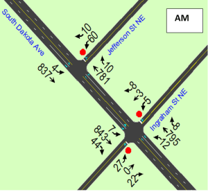
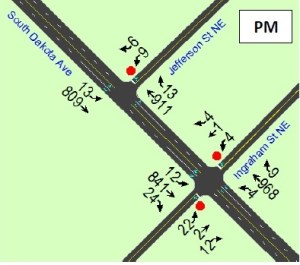

DDOT conducted a study per their standard 2009 manual practice in response to “perceived unsafe crosswalk conditions [including for the blind and elderly].” A “Professional Traffic Engineer” assessed vehicular and pedestrian volumes at “stop-controlled intersections” on Wednesday, December 6, 2017, during the peak hours of 8:00 am to 9:00 a.m. and 5:00 pm to 6:00 pm.
| Ingraham | Jefferson | |
| Distance from Signalized Intersection | 250 ft from Hamilton | 275 ft from Kennedy |
| Vehicles | 1700-1900 | 1700-1900 |
| Pedestrians | 43 | 28 |
| Bicyclists | 4 | 4 |
| Vehicle-Vehicle Crashes (01/01/2013-12/31/2015) | 3 | 3 |
In addition to the pedestrian, bicyclists, and vehicular counts, the report also noted the following items related to the intersections:
DDOT used a scoring matrix to evaluate the need for a HAWK signal. A simplified version is shown below with the score from their 2017 study (refer to the full report for explanation of the variables).
| Variable | Points Possible | Points Awarded |
| Pedestrian and Bicycle crashes (over recent 3-year period) | 20 | 0 |
| Vehicle Crashes (over recent 3-year period) | 10 | 6 |
| Street Traffic Volume | 30 | 30 |
| Number of lanes at peak hour | 30 | 10 |
| Elderly and disabled population | 10 | 0 |
| Proximity to K-12 School | 15 | 9 |
| Connection to parks, rec center, commercial, etc. | 15 | 15 |
| Metro station / bus stop | 20 | 0 |
| Posted speed limit | 15 | 5 |
| Distance to nearest signalized intersection | 30 | 0 |
| Crosses bike path | 5 | 0 |
| Total | 200 | 75 |
The Decision
According to their data, vehicular and pedestrian traffic counts warranted a HAWK signal at Ingraham street. But, as their report states, “satisfaction of meeting a warranting criteria shall not in itself justify the installation of a new traffic signal. Rather multiple site-specific factors must be considered, and engineering judgment applied before justifying any change in traffic control.”
Though we received an overall failing grade, the report also recognized pedestrian volumes would likely increase when the retail at the Modern opens.
Here is my take
For starters, their study does not appear to be the most rigorously designed. From being conducted on a single day, for only two hours, by one person, likely with temperatures that discouraged walking, lack of good lighting, and the Modern apartments barely open with no retail at that time, it seems unlikely that accurate and usable data would be obtained as the basis to make a decision.
The proximity to two other signalized intersections (Kennedy and Hamilton) appear to be the biggest reason why a HAWK signal was denied. Generally speaking, DDOT discourages traffic signals from being placed within 300 feet of each other because “challenges [exist] with signal coordination, driver confusion and lack of vehicle queuing space.” Putting aside the fact that HAWK signals have been installed to “help pedestrians safely cross [other] high traffic volume streets” (I’m looking at your ”mid-block crosswalk” Cleveland Park), I do find it dismaying that they would cite “driver confusion” here when pedestrian safety is just as critical (see any recent editorials on Vision Zero). The truly funny thing is that if the traffic signal had been installed at Ingraham to begin with, instead of being kept at Hamilton, then that would actually be more than 300 feet from the lights at Kennedy and Galloway.
DDOT also cites the “adequate sight distance for pedestrian visibility,” lack of pedestrian involved traffic crashes, and that “gaps” in through traffic are created with the current signal timing plan as additional factors to not install a HAWK signal. However, anybody waiting to cross those intersections would likely attest to the inadequate visibility they feel as pedestrians, especially when attempting to navigate the gaps in the platoon of cars barreling down South Dakota Avenue.
Speaking facetiously of course, I guess we need to have more pedestrian-involved crashes first to have more points on the DDOT scoring matrix, which would then help justify our request for increased pedestrian safety. But seriously, we really should not be waiting until any other unfortunate tragedies such as this one occur before the city takes action to install pedestrian safety measures within 250 feet of another signal. When it comes to the lack of pedestrian and bicycle crash incidents from 2013-2015, the Ingraham intersection in question did not even exist. The apartment building was under construction most of that time and the new street did not exist. A more appropriate use of pedestrian safety data would be all the 311 submissions neighbors have made regarding near crashes and other concerns since this intersection has been accessible by foot.
Going back to DDOT’s scoring matrix, no points were given for the elderly and disabled populations, despite that being part of the premise for the study. The intersection’s proximity to the metro did not yield points either, even though Ingraham is the through street to the metro.
Finally, DDOT did not independently act on a list of additional recommendations that were made in the report. Instead, neighbors needed to make numerous 311 requests to prompt the pedestrian safety enhancements. Such requests ended up being similar to the report’s recommendations unbeknownst to us, such as increasing crosswalk monitoring and installing high visibility pavement markings for the Jefferson Street crosswalk.
What’s Next
This is not the end of the story. At both the December Lamond-Riggs Citizens Association meeting and the brainstorming session, DDOT agreed to perform another study to evaluate if a HAWK signal is warranted now. Let’s hope they work with the community to design the best study possible.
Please join us at the next Advisory Neighborhood Commission 5A meeting where the topic of increasing pedestrian safety crossing South Dakota Avenue will be discussed. A draft resolution will be presented to the Commissioners as well. The meeting will be Wednesday, January 30, 2019 at 6:45 p.m. at UDC-CC Backus. If you want to submit a letter of support regarding this issue, please email a 250-word statement here.
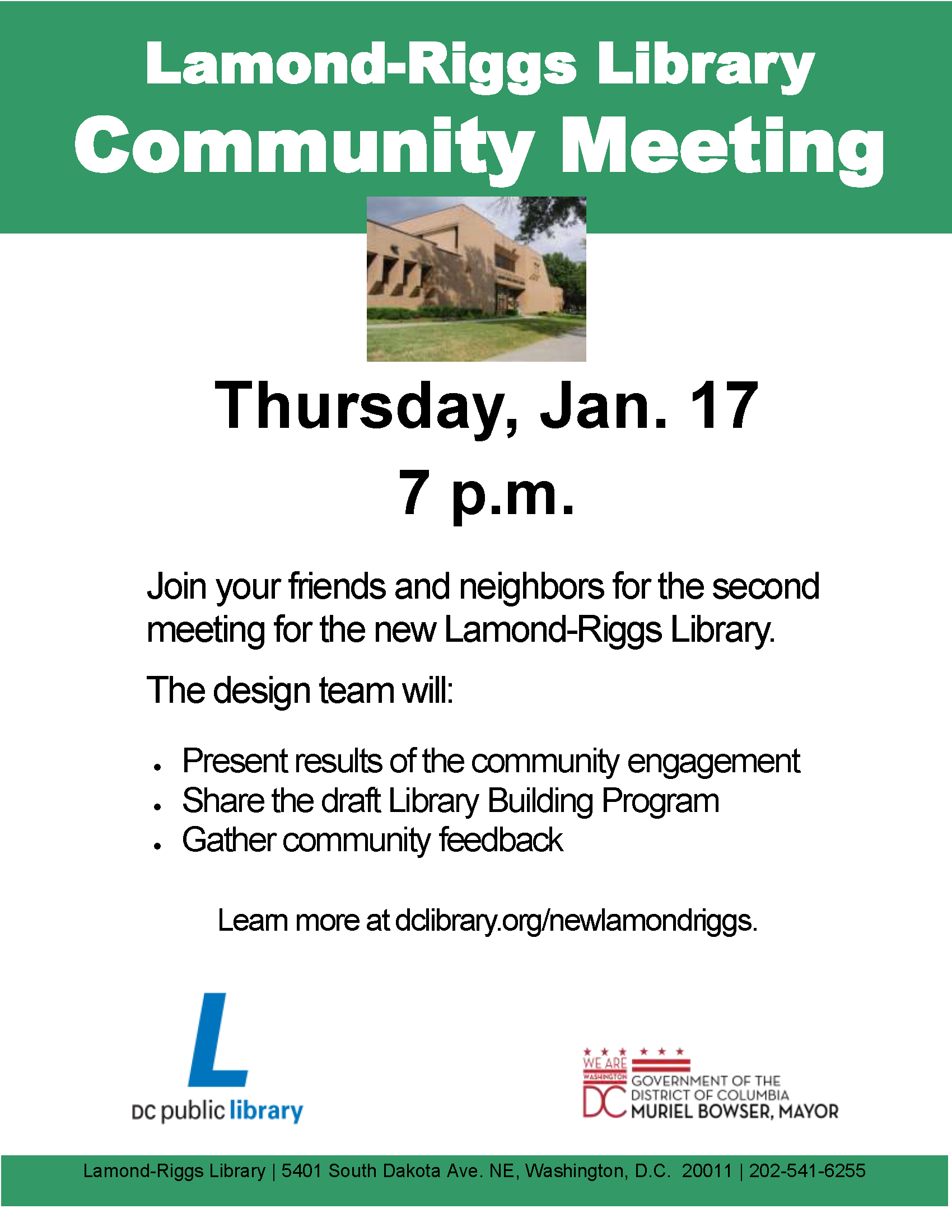
Lamond-Riggs Library
Reconstruction Community Meeting
January 17, 2019
7:00 pm
5401 South Dakota Avenue NE
Design team will present results of community engagement to date, share the draft Library Building Program, and gather community feedback
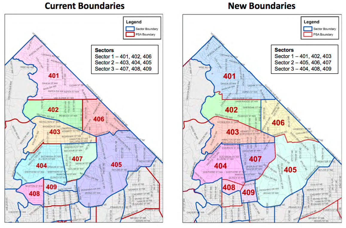
Map of old PSA boundaries (left) and new PSA boundaries (right)
Effective today, MPD has realigned police service areas (PSAs) for the neighborhood. Previously, the neighborhood was served by two different PSAs in two different sectors–PSA 405 in Sector 2 served residents south of Kennedy Street NE and PSA 406 in Sector 1 served residents north of Kennedy Street NE. Now, all of Riggs Park will be served by PSA 406 in Sector 2.
Each sector consists of three PSAs and is managed by a captain. MPD lieutenants and captains change often so be sure to visit MPD’s Fourth District webpage to keep up-to-date if you ever need to contact your police officers (though it does not appear that MPD has updated the webpage as of the time of this writing).
Lamond-Riggs Library Reconstruction Community Meeting
January 17, 2019
7:00 pm
Lamond-Riggs Library (5401 South Dakota Ave. NE)
Please join your neighbors for the 2nd community engagement meeting regarding reconstruction of the Lamond-Riggs Library with DCPL officials and the design team
Agenda:
(1) Hear about the results of community input to date
(2) Review the draft Library Building Program
Project website: https://www.dclibrary.org/newlamondriggs
ANC 5A held a special public meeting on January 8, 2019. By acclamation, the commission voted for the previous officers to continue serving in their respective positions. Ward 5 Councilmember Kenyan McDuffie swore in the officers.
Ronnie Edwards (5A05) – Chair
Gordon Fletcher (5A08) – Vice Chair
Sandi Washington (5A07) – Treasurer
Isaiah Burroughs (5A04) – Secretary
Grace Lewis (5A02) – Parliamentarian
Prior to the vote, there was discussion about having Commissioner Emily Lucio (5A03) serve as secretary rather than Commissioner Burroughs (5A04). The two commissioners decided beforehand though that Commissioner Burroughs will serve as secretary until he graduates from Catholic University in May, at which point Commissioner Lucio will assume full secretary duties. Until then, Commissioner Lucio will Commissioner Burroughs with getting a functioning website for the ANC and doing a better job in distributing timely meeting notices.
Pax Liquor Store Protest
The ANC continues to prepare for the protest hearing regarding the application of Pax Liquor to locate at 4944 South Dakota Avenue NE (near the McDonald’s). The ANC will have to make its case for why the establishment does not meet certain appropriateness standards. The hearing will be held at 4:30 pm on January 16, 2019, at the Reeves Building (2000 14th Street NW).
Commissioner Lucio (5A03), the new commissioner for the single member district (SMD) in which the liquor store seeks to locate, will appear on the local television show DREAMS the Capital View on January 10 to discuss the ANC’s protest. Residents are invited to be part of the audience. If you are interested in attending, please arrive at the station located at 901 Newton Street NE by 6:20 pm. Find archives of the tv show under DREAMS the Capital View. View a video of the street protest held by residents and commissioners earlier this year.
The commission also asked residents to pack the hearing room on January 16. The Reeves building is conveniently located near the green line. The ANC recommended GoGo Grandparent for seniors who are not able to use public transit. This service provides Uber and Lyft rides for seniors without a need for a smartphone. Call (855) 464-6872 for information.
Councilmember McDuffie submitted a letter in support of the ANC’s opposition to the liquor store and will have a staff member present at the hearing.
Wesley Housing Curb Cut Application & PUD
Representatives of Wesley Housing did not show up to discuss their application for a curb cut/driveway on the property located at 1 Hawaii Street NE in the Fort Totten/Pleasant Hills neighborhood. The property is bounded by Hawaii Street NE, Allison Street NW, and Rock Creek Church Road NW. The application was filed at the end of December; the ANC has 30 days to respond. The property is in the SMD of Commissioner Sandi Washington (5A07), who appeared to oppose the curb cut because it would take away on-street parking spaces on Allison Street. The application seeks to move the existing curb cut on Rock Creek Church Road to Allison Street.
Even more importantly though, on January 4, 2019, after the curb cut application was filed, Wesley Hawaii LLC, an affiliate of Wesley Housing, also filed an application for a planned unit development (PUD) and zoning map amendment for the property to change the zoning from RA-1 to RA-2 to permit greater density. The case number for the PUD application is 19-01. The property was acquired in 2018 from Sanford Capital, the infamous landlord sued by DC Attorney General Karl Racine to divest its properties in DC due to poor property management. The proposed plan would replace the existing apartment building at 1 Hawaii Avenue with a five-story apartment building with 78 units. The new building would have a 100% affordability covenant for a certain period of time. See Applicant Statement: Wesley Hawaii LLC Statement in Support of PUD Application (pdf)
Commissioner Washington thought it improper for the applicant to file for the curb cut before filing the PUD application. A footnote in the statement in support of the PUD application notes,
Though the Existing Building with 34 units has no parking, there is a curb cut from Rock Creek Church Road NW. However, pursuant to preliminary discussions with the District’s Department of Transportation, the Applicant will locate a new curb cut on Allison Street NW to provide access for parking and loading. The Applicant recently filed an application for concept review with DDOT’s Public Space Committee.
The commission tabled the curb cut issue until the next regular ANC meeting, which appears to be scheduled for January 30.
Post updated with flyers and correction to Proposal 3
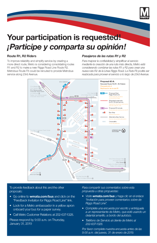
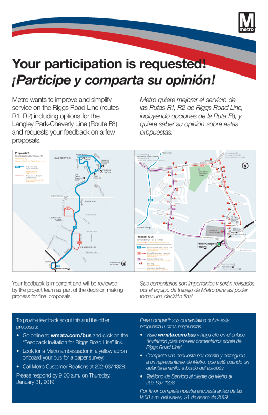
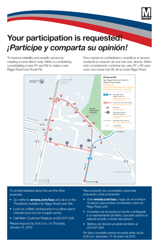
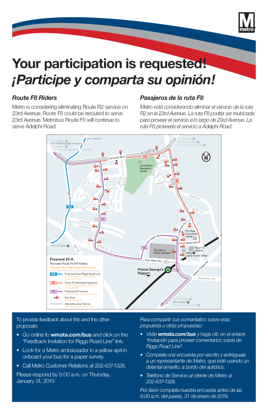
Metro Riggs Road Service Evaluation Study
Metro is seeking input on proposals that will impact the Riggs Road Line (routes R1, R1). These proposals will impact service in the neighborhood.
Proposals:
1. Extend Route R2 beyond Calverton
2. Consolidate Routes R1 & R2 to make a new R2 Line that will be more direct along Riggs Road; reroute F8 to serve areas that would be removed from the new R2 line, including parts of East-West Highway and University Boulevard
3. Consolidate bus stops on routes C4, C8, F8, R1, R2, & Z6 to remove stops that are not used frequently or that are close to other stops
How to provide feedback:
Responses are due by 9:00 am on January 31, 2019
Guest post by Sarah Shank
Post updated
Before the widespread availability of the internet, communities were built in the streets and on porches. This is how and where neighbors connected, news was shared, and families celebrated. It was rare that neighborhood happenings would go unnoticed. Community leaders united the neighborhood by spreading neighborhood news, organizing neighborhood watches, igniting local activism, and welcoming new neighborhood residents.
Lamond-Riggs is a community of leaders. Our residents have done this for decades and continue to be a force in the District. Even the mayor got her start in politics living in this corner of the diamond–first as ANC, then councilmember, then mayor–before moving to Northwest.
After living in DC for more than 20 years – in many different neighborhoods across the District – I’m proud to now call Lamond-Riggs home. While I’m a newcomer to the neighborhood (going on only 2 years now), I picked to live in this neighborhood for a few reasons: its established community, commitment to its residents, and the neighborhood family feel that it retains. I’m continually amazed by the civic engagement that residents have and the rich history that surrounds us.
We are a neighborhood of firsts.
And while many of these firsts are from way before my time, but none are by any means small and I’m just naming a few!
We are a neighborhood of activists.
As the headline to a 1988 Washington Post article notes, “For a small neighborhood tucked away in a corner of Northeast Washington, Riggs Park has made a lot of noise over the years.” So from the creation of Bertie Backus Junior High School in the 1950’s, to the freeway fights of the 1960’s and 1970’s, to construction of Fort Totten metro station in the 1970’s, to construction of the neighborhood library in the 1980’s and now again today – throughout time, residents developed and maintained a thriving, mixed-income community with strong civic participation.
Come to any Lamond-Riggs Citizens Association monthly meeting and you’ll see that civic engagement still happening to this day.
We are a neighborhood of families.
Young and old. Then and now. Our homes have yards and alleys. Our homes are filled with hard-working DC families. While accessible by metro, our neighborhood provides refuge from the daily grind. It has big open sky and it’s our home away from the city but still in the city – aren’t we lucky!
Founded in 1980, the Humanities Council of Washington, DC (HumanitiesDC) aims to enrich the quality of life, foster intellectual stimulation, and promote cross-cultural understanding and appreciation of local history in all neighborhoods of the District. They allow neighborhood organizations and individuals to apply for grants to help document and share their story of DC through oral histories. Through these DC Oral History Collaborative grants, HumanitiesDC aims to document and preserve the stories and memories of residents by making existing oral history recordings more accessible and giving residents the training and financial resources they need to conduct quality interviews.
With this type of financial support, we together can record the stories that bore witness to the neighborhood’s early years, allowing us the opportunity to capture key moments in the neighborhood’s history over the past seven decades. These stories should be documented and shared with our own community as well as have our civic pride touted to every other corner of DC.
I’m eager to apply on behalf of our neighborhood because I see tremendous value in the stories that we have in Lamond-Riggs. But to do this, I need the help and support of all my neighbors and friends. Our residents have a unique view of this Capitol city that I want that not only recorded, but also shared.
Send me your ideas.
Send me your photos (I promise to scan and return them).
Tell me your memories.
The grant application is due on January 25, 2019. This means there is still time to include as many of our community ideas into the grant application as possible. If we are awarded the grant, the funds will be used to record oral histories from five to ten Lamond-Riggs residents. We will supplement the recordings with photos. And if we have more people who want to tell their stories, we can always do more! Also, if we don’t win the grant, I still hope to begin collecting stories and documenting the legacy of our community and its residents so that this rich history can live on for generations to come.
I’m confident that by collecting and sharing these stories, we’ll be able to instill the same sense of community and activism in the next generation, so that they can continue to make this neighborhood one of firsts and families – much like it has always been.
Please feel free to comment below with comments and/or ideas. Or please send me a note directly here.
The Center for Nonprofit Advancement is pleased to announce the creation of the South Dakota Avenue/Riggs Road Main Street Program.
Funded through a grant awarded by the District Department of Small and Local Business Development (DSLBD), the Main Street Program will utilize public-private partnerships and community volunteers, build on neighborhood assets, and implement strategies to support and improve the business corridors in the Riggs Park and Manor Park neighborhoods.
The search for an executive director is open! Submit a cover letter and resume to SouthDakotaRiggsMainStreet@gmail.com with “Application SDA-Riggs Road Main Street ED” in the subject line. Applications may be submitted in Microsoft Word or pdf format. The deadline to apply is 5:00 pm on January 14, 2019.
Find more information at https://lrcadc.org/sda-riggs-road-main-street
ANC 5A Special Public Meeting
January 7, 2019
6:45 pm
The Modern, 400 Galloway Street NE (across the street from UDC-CC Backus)
Agenda:
1. Election of Officers
2. Pax Liquor Store Protest/Hearing Update
3. Wesley House – 1 Hawaii Avenue NE Update
DDOT Public Space Application Curb Cut/Paving: Driveway
Guest Post by David Kosub
*** Please note David is only a citizen historian and apologizes for any incidental fake news. He hopes neighbors share these stories and are inspired to write about their community in the new year too.*** [Ed. Note: If you would like to contribute a blog post for Next Stop . . . Riggs Park, please send an email to nextstopriggs@gmail.com]
Welcome to Part 2 of our Lamond-Riggs naming story. As you may recall, we met the Lamonds in Part 1 of the series, learned to make Terra Cotta, and found out about a little ol’ horrific train disaster. With that introduction, let’s meet Riggs.
The President’s Banker
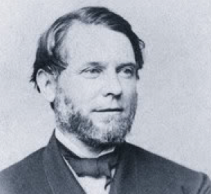
Picture of George Washington Riggs
Born on Independence Day in Georgetown in 1813, George Washington Riggs was definitely a firecracker. A true high-roller 19th century style, Riggs teamed with William Corcoran, of the present-day Dupont gallery fame, in what would become a very lucrative banking empire. Their bank, as a result of a government decision, was the only one allowed to obtain a large chunk of federal depositories in the city, leading to crazy profits. Rolling on all cylinders, they helped finance the Mexican-American War with over $15 million in loans from the federal government, provided over $7 million in gold for the purchase of Alaska, financed the development of the telegraph, provided funds to expand the Capitol, and resourced one of the first expeditions to the South Pole.
Multiple Presidents (including a Confederate one), Cabinet Secretaries, Senators, Generals, suffragettes, Red Cross founders, and many embassies entrusted their treasures with Riggs Bank. Riggs himself retired from the bank in the late 1840s, but his family had a stake in the institution until the early 20th century. In 1904, their new headquarters on Pennsylvania Ave was notable for its “Ladies’ Department,” designed to meet the special needs of women, including Clara Barton and Susan B. Anthony (ooh la la).
Riggs spent much of his time not too far from where you currently sleep. His 197-acre country estate was situated on a high vantage point, with views of the U.S. Capitol (though technically outside the city back then). You may know of this area now as the Armed Forces Retirement Home after the federal government purchased it from the Riggs estate in 1851 for $57,000 (after paying only $3,400 to purchase the site nine years earlier). It was on these grounds in the summer of 1862 where President Lincoln penned the final draft of the Emancipation Proclamation (only a dozen years after enslaved persons may have lived here too). Today, now recognized as a DC historic site and on the National Register of Historic Places, this property has sculptured landscapes, war memorials, and the original Gothic Revival-style cottage which bears the Riggs name.
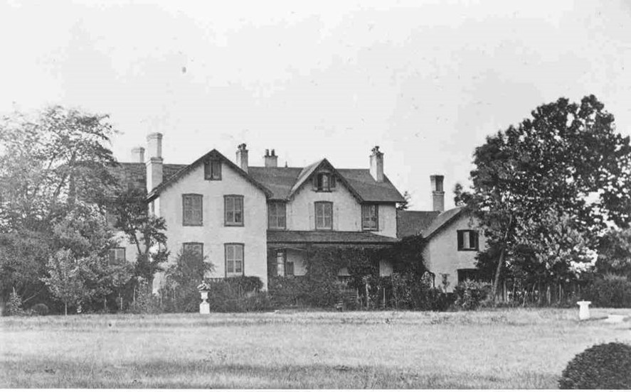
Lincoln Cottage. Source
Because you cannot hide money, Riggs established a second country estate – a new, slightly more modest 140-acre one known for its “fine blooded cattle” in present day Silver Spring. Alas, this one had to be sold too, a mere week after a “skirmish” between Union and Confederate troops that left the nearby vicinity torched and plundered in 1864. Though 300 people died, the Riggs family suffered too, losing “some hay forage,” vegetables, and a valuable ox.” Today, the property serves as a private school for students with learning disabilities.
At the age of 68, Riggs passed away in his Green Hill home—yes, a third country estate, which was 342 acres in Hyattsville and included the only mill still surviving in Prince George’s County. An obituary crooned that Riggs was “remarkable for strength of mind and . . . power to grasp and fathom any subject presented to him . . . and in all his transactions, his judgement prompt, and his conclusions just.” Wow, it’s like reading a biography of yours truly. Not too far from the Lamonds, Riggs can also be found lazing around Rock Creek Cemetery too (section D, Lot 14) – just a 25-minute stroll from the community bearing his name.
Bankers to the Most Important Money in the World – Yours
Now, let’s check back in with Riggs Bank (see these simply amazing commercials here, here, here and the 1980’s jingle here). Lasting over 150 years, with multiple iconic branches in the District, including Georgetown, Dupont, and across from the U.S. Treasury, it kind of fell with a thud. Though not as cool as this sort of Riggs downfall here, the bank’s failure in the early 21st century was just as epic and followed, wait for it . . . a handful of money laundering scandals resulting in the company paying millions in fines and penalties.
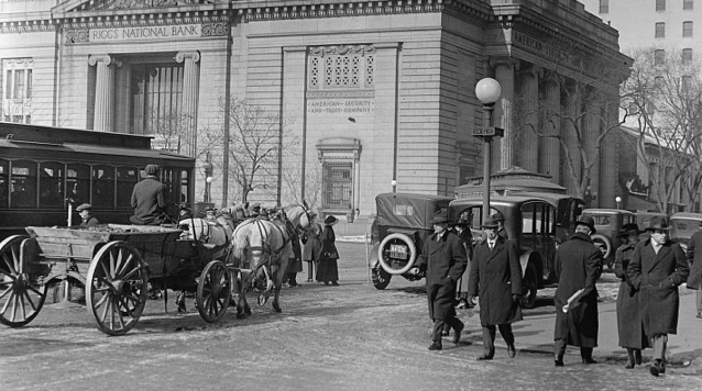
Image of Riggs National Bank ca. 1913-1918. Source
Remember those embassies mentioned earlier, and their treasures too? Well, various employees at Riggs Bank were caught embezzling over $30 million in oil revenues from the Embassy of Equatorial Guinea on behalf of that country’s dictator. One of the employees at the Dupont branch would apparently even walk up the road to the embassy and collect briefcases containing stacks of shrink-wrapped bills. The bank also was connected to yet another dictator, this time with Chile, helping him hide additional millions (see here how the bank tried to make good on this one). Federal reports also noted that the bank “inadequately monitored the destinations and uses of large amounts of cash, often more than $1 million at a time” in over 150 accounts linked to the Saudi Arabian embassy and ambassador (it even got a shout out on Meet The Press). And, of course, the bank was linked to the CIA too, because, why not?
Alternative facts: What If . . .
It is still unclear to me, however, why our neighborhood went from being known as Terra Cotta to Lamond-Riggs (Lamond & Riggs Park neighborhoods collectively) today. I find it a shame because Terra Cotta sounds pretty cool actually. I would like to believe that it goes deeper than just the nature of evolving communities and adjacent streets . . . like maybe the two families knew each other at some point in their life.
Perhaps Riggs issued a loan to Lamond to start the plant, who then reciprocated with a gift of the first clay tile hot out of the oven. Or, maybe Alcena caused an uproar at a citizen’s association meeting over the most hyper-local issue of the day — overgrown trees, unsafe pedestrian crossings at train tracks, silent invocations, and potholes, yes definitely potholes. Perhaps they shared stories over a pint during a Thirsty Third Terra Cotta Thursday too.
Regardless of the reason, we all live here together and have made it the tight, close-knit community it is today. As history happens every second of every day, let’s continue to create it, stroll through it, welcome it, and learn about the hidden mysteries that exist right under our noses.
Guest post by David Kosub
*** Please note David is only a citizen historian and apologizes for any incidental fake news. He hopes neighbors share these stories and are inspired to write about their community in the new year too.*** [Ed. Note: If you would like to contribute a blog post to Next Stop . . . Riggs Park, please send an email to nextstopriggs@gmail.com]
Back in 2011, all around the DMV, we found ourselves asking, “What is NoMA anyways”? After Amazon made its announcement, we found ourselves wondering something similarly–“National Landing, really”? I guess it’ll be called NaLa soon enough.
Even closer to our “scrappy, down-home” neighborhood, if you want to see sparks fly, then ask someone about what they think about the name “Fort Totten Square,” or about their initial impressions of “Fort Totten” metro. But, be careful. Make sure you do not call it Fort Totten-Riggs station though. For that matter, where did the name “Lamond-Riggs” come from anyways–or as I call it, LaRi?
Here, in this two-part series, I sought to uncover this mystery and meet the elusive Lamond and Riggs. In Part 1, let’s start by turning the clocks back about a century and a half and meet the Lamonds.
Terra Cotta Warriors: A Different Type of Baked Earth in Washington
There is a silty, reddish clay earth right beneath your feet. This soil, the bane of many area gardeners – like yours truly – who just want to grow some darn tomatoes and peppers in their yard, actually contributed to a vibrant industry over a century ago. Heating this ample clay-ground proved perfect for making a certain material commonly found in sculptures, flower pots, pipes, bricks, roofing tiles, and even metro platform embellishments.
And, voila, the Terra Cotta neighborhood was born. The Federal government officially recognized this description in 1979, the same year as the names Lamond-Riggs and Fort Totten Park, and it still existed as recently as 2007.
This name is linked to a thriving business established here in the latter half of the 19th Century, the Potomac Terra Cotta Company. Its impressive, large ovens could be seen creating clay tiles on the eastern side of the recently laid Baltimore and Ohio train tracks, near today’s Van Buren Street, Underwood Street, and Chillum Place.
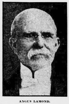
Picture of Angus Lamond
Drum roll please, this company was the brainchild of one Scottish-born Angus Lamond. He started the company some time after immigrating to the United States at the age of 25. With Gaelic and Norse origins, his family name meant “the law man” and was llikely pronounced “Laumon.” If you cannot get enough Game of Thrones, check out this actual ancestral history of the Lamonts of Tiree, from which our hero Angus may have derived.
In 1873, officials with the railroad, specifically the Metropolitan Branch rail line, moved the nearby Brightwood station closer to the company, renaming it Lamond Station or Terra Cotta. Likely located somewhere between where Fort Totten and Takoma metro stops are today, the relocation of this simple, three-sided wood-framed structure caused some consternation. The railway thus justified the move by explaining that the station was better protected from vandals at the new site.

Advertisement for Potomac Terra Cotta Company. Source:
The new station served another role too, incentivizing people to move to an unincorporated parcel of land destined to be a nuclear-free, suburban oasis located “high above the swampy, malaria-ridden Washington City.” When Alcena Lamond, Angus’s better half, encountered it in 1875, she lamented that the area “was all that a wilderness could be.”
Even with the fear of the unknown, the Lamonds would come to embrace the wild. The town would grow without regard for jurisdiction, incorporating part of the large Riggs estate (but we will get to Riggs later in Part 2). By 1889, this “place only for the wild creatures of nature” expanded from the original 5 homes—one of which was the Lamonds—to over 200.
The call of the wild was so strong that Angus and Alcena even donated land for a library, though not likely the one you are envisioning. Angus allegedly convinced his childhood friend Andrew to give a $40,000 construction grant, which together with the land, eventually became the Takoma Park Carnegie library in the early 20th century. Before it could become reality, the contribution of the “best men” in Takoma Park needed to testify at a House hearing in 1907, including Angus who was glorified as one of the “most generous” and “prominent” citizens during the lovefest. A Congressman touted the library would be a “valuable addition to the educational facilities of the District of Columbia . . . [and] that the remoter sections of the District are entitled to the largest possible use of the Washington Public Library.” Let’s keep that in mind as our local branch gets its own upgrade over the next couple years!
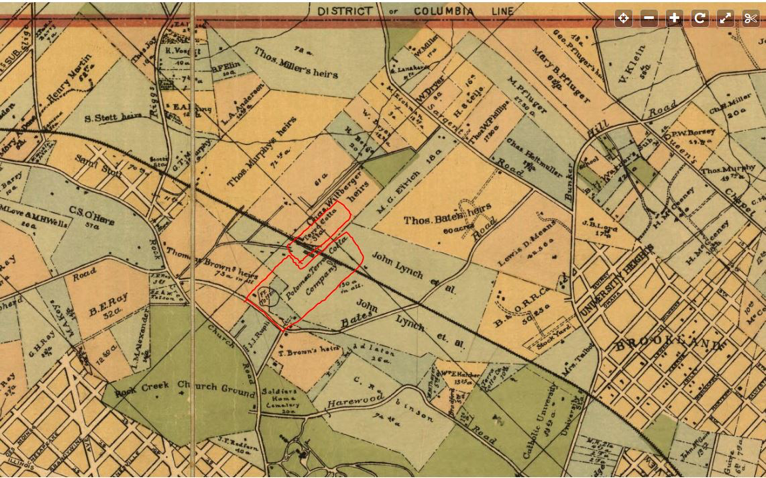
1890 map of Terra Cotta neighborhood. Company and railroad are circled in red Source
Alcena, the true rock star she was, worked her magic on the 57th Congress to pass legislation in 1902 to incorporate the Eastern Star Home for the District of Columbia. This institution was a home for “needy and worthy [fathers, their widows and orphans, and members] of the Order of the Eastern Star of [the District of Columbia].” The Order of the Eastern Star is a Masonic group (complete with its own International Temple in Dupont) that recognized her as a Grand Matron in 1896. Angus was prominent in Masonic circles too, recognized as a Grand Patron. The Eastern Star Home, essentially a nursing home off New Hampshire Ave NE, naturally (being D.C. and all) was destined to be a future sight for a zoning fight between the District, neighbors, and developers over a century later.
Meanwhile, back at the Terra Cotta Plant, work was seemingly difficult producing those clay tiles. For starters, it claimed the life of one of their sons in a tragic clothing-related accident in 1922. The other son also lost an arm while working in the factory. But, despite this incident, this son would successfully manage the company for decades until its closing in the mid-1950s (so, give him a hand for that, he needs it). Some of their clay fixtures can even probably still be found on houses in our neighborhood today.
Angus, who died in 1917 around the age of 75, and Alcena, who died in 1932 around the age of 82, both now leisurely hang out right around the corner in Rock Creek Cemetery (Section R11, Lot 49, Grave 3 and Grave 1, respectively). They are just a 25-minute stroll from the community bearing their name, so pay them a visit.
Train Spotters (caution ahead)
For an additional, unfortunate twist of fate, the Lamond/Terra Cotta station is known for the worst train disaster in Washington D.C. history, one hundred years before the one you are likely thinking about. This accident was later recounted in the book Undergraduate Days 1904-1908 as a “terrible noise…of an explosion, escaping steam, breaking wood, groaning brakes and human screams” heard as far away as Brookland and Catholic University. A newspaper recounted that “the butchery of the passengers was one of the most frightful things in the history of railroading.” They were cut into pieces and portions of their bodies scattered all along the track. When all was said and done, 53 passengers lost their lives, over 70 were injured, and none of the engineers on the offending train were found guilty of manslaughter.
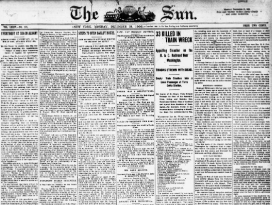
Image of newspaper article on train crash
A citizen historian who spent 10 years studying the crash opined that this incident “hastened the conversion of passenger cars from wood to steel and led to improvements in railroad signaling,” so I guess there is that silver lining. Though if you need another pick-me-up right about now, as I did when writing this, then see this happy story about the Fort Totten metro train tracks before going to bed.
So, that was the Lamonds. Stay tuned for Part 2 of our naming saga in which we’ll learn about bankers, emancipation, and dictators, oh my . . .
ANC 5A Special Public Meeting
January 7, 2019
6:45 pm
UDC-CC Backus (5171 South Dakota Ave. NE
Agenda:
1. Election of Officers
2. Pax Liquor Store Protest/Hearing Update
3. Wesley House – 1 Hawaii Avenue NE Update
DDOT Public Space Application Curb Cut/Paving: Driveway