September 2: MBT meeting

For those of you interested in the Metropolitan Branch Trail (MBT), there will be a meeting on what is being called the South Manor Park alignment (portion between Riggs Road NE and Oglethorpe Street NW, with emphasis on 1st Street and McDonald Place NE) this Wednesday.

MBT South Manor Park map

Meeting details:

St Paul Church and DC Councilmember Todd are hosting a meeting to discuss the trail alignment in the South Manor Park area

Here are the details:

Wednesday, September 2, 2015

6:30-8:00 pm

Greater St. Paul Baptist Church

5720 South Dakota Ave (aka 1st Street) NE


Proposed Metrobus Changes

Metro is proposing service changes to several bus lines. Reprinted from Metro’s website below are just some of the proposed service changes. Visit Metro’s website for a complete list and to take a survey to let Metro know how the proposed changes will affect you.

5A DC-Dulles Line

Proposed Change:

• Eliminate the entire line.

Reason for the Change:

• The Silver Line, Fairfax Connector 981, and the Washington Flyer have reduced the need for the 5A direct bus service between Washington and Dulles.

• Not as many people ride the 5A since the Silver Line opened.

Alternative Transportation Options:

• The Silver Line connects L’Enfant Plaza and Rosslyn to WiehleReston East Metrorail Station. From there, passengers can take Fairfax Connector 981 to Dulles, or Fairfax Connector 551 to Herndon-Monroe Park & Ride.

• The Washington Flyer also provides service between Wiehle-Reston East Metrorail Station and Dulles Airport.

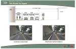
64 Fort Totten-Petworth Line

Proposed Change:

• Add one AM peak trip and one PM peak trip

• Add more time for buses to get from one end to the other.

Reason for the Change:

• To help reduce crowding in the morning and afternoon rush hours.

• It will help buses to be more on time.

Alternative Transportation Options: • No alternative

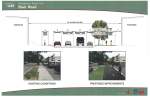
80 North Capitol Street Line

Proposed Change:

• Shorten the route by eliminating service between McPherson Square and the Kennedy Center.

Reason for the Change:

• To help buses arrive on time.

Alternative Transportation Options:

• Route D4 would be extended from Franklin Square to the Kennedy Center. Route D4 buses arrive on a similar schedule as route 80.

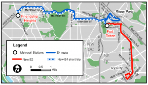
E2 Fort Totten-Ivy City Line & E4 Military Road-Crosstown Line

Proposed Change:

• Add more time for buses to get from one end to the other, on weekdays, Saturdays, and Sundays.

Reason for the Change:

• This will help buses to arrive on time.

Alternative Transportation Options: • No alternative needed.

July 21: Ward 4 Vision Zero event at Takoma metro station

From Washington Area Bicyclist Association

Dates, times, and locations for Vision Zero events:

Date Ward Locations Time
7/15/2015 6 Eighth and H Streets, NE 3:30 pm – 6:00 pm
7/16/2015 3 Cleveland Park Metro Station, NW 5:00 pm – 7:30 pm
7/18/2015 1 14th Street and Irving Street, NW 11:00 pm – 1:30 pm
7/21/2015 4 Takoma Metro Station, NW 5:00 pm – 7:30 pm
7/23/2015 8 Anacostia Metro Station, SE 3:30 pm – 6:00 pm
7/25/2015 2 M Street and Wisconsin Avenue, NW 11:00 pm – 1:30 pm
7/27/2015 2 Seventh and H Streets, NW 3:30 pm – 6:00 pm
7/29/2015 7 Minnesota Avenue Metro Station, NE 5:00 pm – 7:30 pm
7/28/2015 5 Rhode Island Ave Metro Station, NE 5:00 pm – 7:30 pm
8/1/2015 6 Eastern Market Metro Station, SE 11:00 am – 2:30 pm


Add your safety issues Vision Zero Map by visiting http://visionzero.ddot.dc.gov/VisionZero/. To find out more about Vision Zero visit www.DCVisionZero.com.

Crowdsource transportation safety issues around neighborhood

DDOT recently rolled out a crowdsourcing map as part of its Vision Zero initiative. Residents can click on a location on the map to pinpoint hazardous locations or behaviors. This is an opportunity for everyone to put their concerns on the map, literally. Just click on the link.

Vision Zero crowdsource map screenshot

Snapshot of safety hazards one can pinpoint on the map

Much ado has been made about the reconfiguration of the South Dakota/Riggs Road intersection, but there are a few problems that need to be addressed there and on nearby streets. It would be great if DDOT addressed them before the Walmart opens.

  • The turning radius from northbound South Dakota west onto Riggs is completely off. I witness many a driver either hitting the median with their rear tires or enter the turning path of the car next to them. This might not fit directly into the initiative, but because drivers have a hard time making the turn, sometimes drivers end up getting stuck in the intersection once the left-turn arrow has turned red. If DDOT does not want to remove or change the median (my understanding is this small median is supposed to be a pedestrian island), then maybe painted turn lanes will assist drivers in navigating that turn.


  • The placement of the curb cut and crosswalk on the southwest corner of Riggs & South Dakota takes pedestrians out of the line of vision of eastbound drivers on Riggs turning south onto South Dakota. Drivers will already have begun their turn before they realize that there is a pedestrian waiting to cross. If DDOT does not want to move the crosswalk, then perhaps giving pedestrians a headstart would work.


  • Where 2nd Street and 3rd Street meet just past Riggs is a big problem. A resident noted that there are no crosswalks anywhere in the vicinity and drivers tend to fly by on both streets. I do not know if reconfiguring the streets into a 3-way T with stop signs would work, but something needs to be done, preferably before the Walmart opens. (We can have a completely separate post on traffic fixes we would like to see addressed before the Walmart opens, such as the fact that we are convinced people will try to turn left out of the garage onto 3rd Street, which will create a huge traffic mess, but that is another post for another day).
2nd-3rd St intersection

2nd – 3rd Street intersection

Those are just a few problem areas. Please use the map to pinpoint places that need to be addressed. If a location is already highlighted, click on it again to add your own unique comment.

DDOT notes this crowdsourcing map does not replace 311, through which residents can make reports either online or by phone. While 311 is not perfect, I did use it to get a double-sided stop sign on my street because a tree was blocking a stop sign and drivers were inadvertently running the stop sign. DDOT came out to investigate and determined that there was indeed a hazard and put up a double sided stop sign on the other side of the street and painted high-visibility crosswalks with a stop line on each corner. I have also noticed residents crossing South Dakota at Jefferson Street to cut through to the metro station. That is a perfect place for a 311 request to have the crosswalk repainted. So let’s use the Vision Zero map to highlight problem areas, but let’s also make 311 requests while we’re at it.


Proposals for reduction in metro service to add more blue line trains

Catching up on news. A few articles mention that Metro will consider recommendations for service changes that would affect frequency of rush hour service on several lines. According to WAMU, “Rush Plus service on the Yellow Line would be eliminated, and the number of rush hour trains on the Green and Yellow tracks would drop from 26 to 15 per hour in each direction, which may lead to crowding on those two lines north of downtown D.C. between Fort Totten and Mount Vernon Square stations.” Service on the orange, blue, and silver line trains would also be affected by the recommendations. Metro will survey riders and hold public hearings before approving any service changes, so stay tuned for opportunities for input.

Route/schedule adjustments coming to E Line Metrobuses serving Fort Totten/Riggs Park

According to Metro’s planning blog, permanent service adjustments to E line buses will become effective June 21:

    • Route E2 will be revised as the Ivy City-Fort Totten Line. The route will operate between Ivy City and Fort Totten station only, and will no longer connect to Friendship Heights station.
    • Extra “short trips” on Route E4 will be added, which will connect Fort Totten and Friendship Heights station (bypassing Riggs Park).
    • The E3 weekend designation will be eliminated, because the new E2 and E4 will operate seven days a week.

E2_E4_brochure-300x174

More on MBT extension (on tonight’s ANC 5A meeting agenda)

MBT proposed extension map

MBT proposed extension map

If you did not make it to the open house for the Metropolitan Branch Trail (MBT) extension, there will be another chance to learn about the proposed design from DDOT at ANC 5A’s public meeting on March 25. Information about the trail is available on the project website. The WashCycle also has a nice post about the extension.

The new section will run from Brookland to Takoma, so that means that our neighborhood will finally be connected to the existing off-street trail. The new section will run along the railroad tracks from Bates Road to Fort Totten metro station, then along First Place NE, Riggs Road NE, First Street NE, and Blair Road NW. There will also be a new sidewalk on 1st Place NE by the metro station, which is a nice bonus.

The trail experience for the new section will be a bit different from the existing off-street trail because the new section will traverse three major intersections (Riggs Road, New Hampshire Avenue, and Kansas Avenue) and will not run completely alongside the train tracks as the existing off-street trail mostly does.  But, we love that progress is happening to finish the trail.

The proposed design is just a preliminary design. The final design is anticipated to be complete in 2016 and optimistically construction will begin in 2017. Comments may be sent to jim.sebastian@dc.gov.

If you support the trail or have questions, please consider coming out to ANC 5A’s meeting tonight (March 25) at 6:45 pm at UDC-CC’s Backus campus.


March 21 & 23: Learn about the proposed Fort Totten extension to the MBT

Two opportunities are coming up to learn about the Fort Totten extension to the Metropolitan Branch Trail (MBT) and give feedback.  Design is underway to extend the MBT from Brookland to Takoma.  The new section will run along the railroad tracks from Bates Road to Fort Totten metro station, then along First Place NE, Riggs Road NE, First Street NE, and Blair Road NW.

1. March 21, 1:00 pm – 4:00 pm DDOT and ANC 4B are hosting a public open house on the extension.

Location: MPD 4th District Headquarters (6001 Georgia Ave NW)

2. March 23, 6:00 pm – 7:00 pm DDOT and ANC 4B team up again before ANC 4B’s regular public meeting to give the public a chance to view the plans.

Location: MPD 4th District Headquarters (6001 Georgia Ave NW)

The Washington Area Bicyclist Association (WABA) is also hosting an informal happy hour on March 19 at Simple Bar & Grill in Brightwood to build community support for the extension.  RSVP here.

More information about the MBT and the proposed design is available on the MBT website. Comments and requests for information may be directed to jim.sebastian@dc.gov.

March 21: Save the date for public open house on the MBT

We anticipate there will be a meeting in ANC 5A, but in the meantime save the date for March 21 in ANC 4B.  The meeting will be open to everyone.

A message from the MBT Facebook page:

DDOT and ANC4B will host a public open house on Saturday, March 21 to discuss the preliminary design trail from Ft. Totten to Takoma. 1:00 to 4:00 pm at the 4th District police station at Georgia and Peabody, NW. More details to come.


Update on Fort Totten section of the MBT

WashCycle provides an update on the Fort Totten section of the MBT:

DDOT is planning to have a public meeting some time this spring at which they will present the preliminary design of the Metropolitan Branch Trail’s Fort Totten Section. This is the section in the Takoma and Brookland neighborhoods, from Bates Road at the trash transfer station to the Maryland boundary at Eastern Avenue. They hope to have a draft 30% design completed by this summer and a final version of that completed by the end of the year. That would allow for a final design to be funded in FY 2016 and construction in 2017.

Speaking of clearing sidewalks

Developers are not the only offenders when it comes to not clearing sidewalks after wintry weather.  District government tends to be a big offender.  See this picture we took on Monday evening of the sidewalk in front of the DOES building on Hamilton Street.

Hamilton Street sidewalk in front of DOES building

Hamilton Street sidewalk in front of DOES building

Around the corner on South Dakota Avenue, the sidewalk has been cleared in front of UDC-CC, but for some strange reason, the sidewalk on Hamilton is a problem.

Absentee property owners are also offenders.  There is a corner house being renovated on Hamilton Street and the owner never clears the sidewalk. Further up Hamilton Street is a group house with one diligent tenant who clears the walk when he is around, but if he is not, the others in the house do not do so. It might be too much to ask neighbors to clear the sidewalk for an absentee owner, but maybe that is the neighborly thing to do.

Generally though, people have been pretty good about clearing the sidewalks and helping each other out.

Comment on proposed metro path by February 19

There is one week left to comment on the National Park Service’s environmental assessment of construction of a formal path between Gallatin and Galloway Street NE to improve access to Fort Totten metro station. Currently, no funding plan exists to construct a path. However, it is an easier sell if 100 comments are received as opposed to 25.  Let neighbors who do not use computers know how they can comment or invite them over to use yours. Comments do not have to be elaborate. Just let the Park Service know where you stand on having a formal path to get to the metro station.

Ways to comment:

Rock Creek Park
Attn: Fort Totten-North Michigan Park Pedestrian Access Improvements EA
3545 Williamsburg Lane, NW
Washington, D.C. 20008

Comments must be submitted or postmarked by February 19, 2015.

Metrorail service changes for Tuesday morning

Metro alert

Metrorail service information for Tuesday, January 13

Updated: 4:55 a.m. / January 13, 2015

Metro is advising rail customers of the following service changes for Tuesday, January 13, following today’s incident at L’Enfant Plaza:

All Yellow Line service will be replaced with additional Blue Line trains operating between Huntington and Largo Town Center, via Rosslyn. Trains on this route will depart every 12 minutes. Use Green Line trains for service between Greenbelt and Downtown DC.

Blue Line trains between Franconia-Springfield and Largo Town Center will operate every 12 minutes.

Orange Line trains will run every 8 minutes between Vienna and New Carrollton.

Silver Line trains will run every 12 minutes between Wiehle-Reston East and Largo Town Center, with many trains expanded to 8-cars long to provide additional capacity.

Green Line trains will run normal service every 6 minutes between Branch Avenue and Greenbelt.

Red Line service is unaffected and will operate on a regular weekday schedule.

A limited shuttle bus option is available between Pentagon and L’Enfant Plaza, running every 20 minutes. Board shuttle buses from Pentagon on the lower level of the Pentagon bus bays; from L’Enfant Plaza at 7th & Maryland St SW.

FOR UPDATED SERVICE INFORMATION, PLEASE CHECK OUR ALERTS PAGE.

Regular Metrobus and Circulator bus service may provide a good alternate travel option for some riders. To check, use the Trip Planner at wmata.com and select the “bus only” option.


Proposed Capital Bikeshare price increase

Capital Bikeshare is hosting an open house on January 28, 2015, 6:00 pm – 8:00 pm, at the Martin Luther King Jr. Library (901 G Street NW) to discuss proposed price increases, future expansion plans, and rider policy. The price for an annual pre-paid membership would increase $10 to $85. Usage fees for trips over 30 minutes would remain the same. The entire proposed fee schedule is printed in the chart below. Written comments on the proposed fee schedule may also be submitted via email by February 15, 2015.

Proposed price increases

Proposed price increases (source: Capital Bikeshare)


October 18 & 19: Free shuttle buses replace Fort Totten red line trains

From 12:01 am Saturday to closing time Sunday, free shuttle buses replace red line trains between Rhode Island and Silver Spring. From WMATA’s website:

Stations Closed: Brookland, Fort Totten (Red Line platform) & Takoma

Last Train Time Change: The last Red Line train of the night from Glenmont to Silver Spring will depart 40 minutes earlier than normal to allow for shuttle bus connections. On Friday and Saturday nights, the last train will leave Glenmont at 1:57 a.m. On Sunday, the last train will leave Glenmont at 10:57 p.m.

Free shuttle buses will replace Red Line trains between Rhode Island Ave & Silver Spring. Shuttle buses will operate on two routes:

  • Express buses will operate between Rhode Island Avenue and Silver Spring with no intermediate stops. Please add up to 25 minutes of travel time.

  • Local buses will operate between Rhode Island Ave and Silver Spring, making intermediate stops at Brookland, Fort Totten and Takoma. Please allow 15 minutes of travel time for each station stop.

September 20: WABA Walking Tour of Northern Phase of MBT

The Washington Area Bicyclist Association is hosting a 2.2 mile walking tour of the planned northern phase of the Metropolitan Branch Trail (MBT) on Saturday, September 20, 2014.  The tour starts at Fort Totten metro station at 1:00pm and will end at Takoma metro station around 3:30 pm. Click here for more information and to register.

Updates from SMD 5A08 Meeting: Art Place and Metro shortcuts

Art Place at Fort Totten

At last night’s SMD 5A08 meeting, we heard a few updates regarding Building A at Art Place at Fort Totten.  The construction team is waiting for final approval of the traffic control plan to start construction.  The entire site will need to be fenced off before they begin relocating the utilities underneath Hamilton Street NE, which will be permanently closed.  Once construction starts, there will be jersey barriers along the north side of Galloway Street NE so that pedestrians can access the metro station.  That means there will no longer be a parking lane for cars on the north side of Galloway.  The bus stops on both sides of Galloway should remain accessible during construction. 

The architect mentioned one change that they are proposing to the residential parking.  As approved, the residential building is to have around 344 residential parking spaces in a structured garage.  The team proposes to reduce that amount by 80 spaces, dropping 1.5 floors of parking, to reduce costs.  That leaves around 264 spaces for 520 units.  The building will have 141 affordable units (of which 98 will be reserved for seniors), enough to relocate the residents of the Riggs Plaza apartments.  The residential apartment building is slated to have a senior work room/quiet area for seniors, rooftop pool and barbecue area, and fitness room.  In adidtion to retail tenants, Building A will have space for an ANC 5A office, and possibly a daycare center.  They are still working on executing leases with retailers.   

National Park Service Environment Study on Improvements to Paths between Gallatin and Galloway Street NE

The deadline to comment on the National Park Service options for improvements to the paths between Gallatin and Galloway is May 2, 2014.  Visit the project website by clicking here.  In addition to commenting on the specific options, individuals can share anything they wish about the paths.  The official from the NPS emphasized that this is an environmental study, so when they evaluate the comments, they will do so with an eye towards the impact any proposed action would have on the native plants and trees and experience of the park.  He also noted that the NPS does not yet have funding to implement any particular plan, but this environmental study is the first step in determining what they want to do and how much to budget for it.  Commissioner Angel Alston noted that there might be an opportunity for partnership to fund implementation and maintenance of any proposed plan.  The commissioner asks that people print out their comment so that the ANC has a record of the comments (a “print this page” tab will appear once a comment is submitted).  The ANC will vote on a recommendation at the next ANC 5A meeting.

Reminder: NPS will be at tonight’s ANC 5A meeting to discuss metro shortcuts from Gallatin to Galloway Street

  • What:    ANC 5A monthly public meeting
  • When:   Tonight, March 26,2014 at 6:45 pm
  • Where:  UDC-CC, Backus, Room 129 (5171 South Dakota Ave NE)
  • Why:     The National Park Service is doing an environmental study on improvements to the shortcuts people are taking through the parkland between Gallatin and Galloway Streets to access the metro station and bus bays. NPS representatives will be at tonight’s meeting to discuss options.

Can’t make tonight’s meeting? Visit the project website and submit comments by May 2, 2014.

No bidders for Fort Totten metro development

The Washington Business Journal brings us news that there were no submissions to WMATA’s solicitation for joint development at Fort Totten metro station.  The solicitation to develop the large park-and-ride lot went out in November 2013.  Submissions were due March 7, 2014.  Stan Wall, WMATA’s director of real estate and station planning, presented on the project at an ANC meeting in January 2014.  From the WBJ article:

There were no submissions for Fort Totten. At that site, Metro offered a relatively small parcel and required the replacement of roughly 400 commuter parking spaces. The cost of the project would be more than the value of any new development, Wall said, but he expects interest to grow over time.
“It’s not quite ready but I think it’ll be back in a year or two,” he said of Fort Totten.

Essentially, the cost of replacing the 400 or so parking spaces alone is a pretty high financial barrier to development of the property right now.  In addition, potential developers were wary about the two developments already in the pipeline, Fort Totten Square (which will bring 345 apartments to the area) and Art Place at Fort Totten (which is estimated to bring close to 900 apartments).  Once Fort Totten Square is completed in spring 2015 and Art Place is further along, developers will be able to see more clearly the level of investment in the area.

It is not clear if any of this will impact DDOT’s accessibility project around the metro station.  While DDOT is coordinating with WMATA because some of the potential changes will affect WMATA’s property, DDOT’s project is completely separate from WMATA’s solicitation for joint development of the large parking lot.