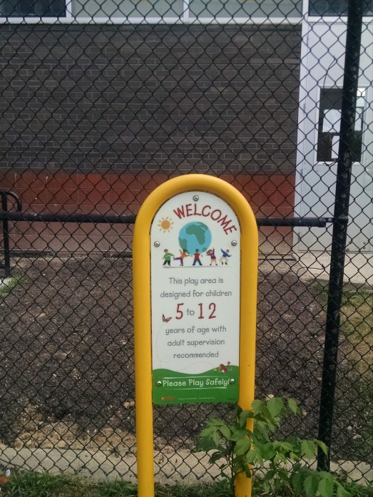
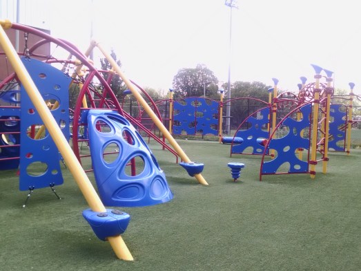
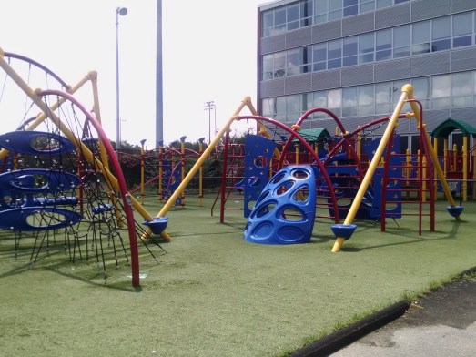
As previously noted, a new playground will be built at Riggs-LaSalle Recreation Center on the Nicholson Street NE side of the center. There will be a virtual community meeting on August 19, 2020. Please plan to attend to learn about the scope of the project and timeline and to get your questions answered.
Riggs-LaSalle Recreation Center Playground Community Meeting August 19, 2020 6:00 pm-7:00 pm Hosted by DC Department of Parks & Recreation
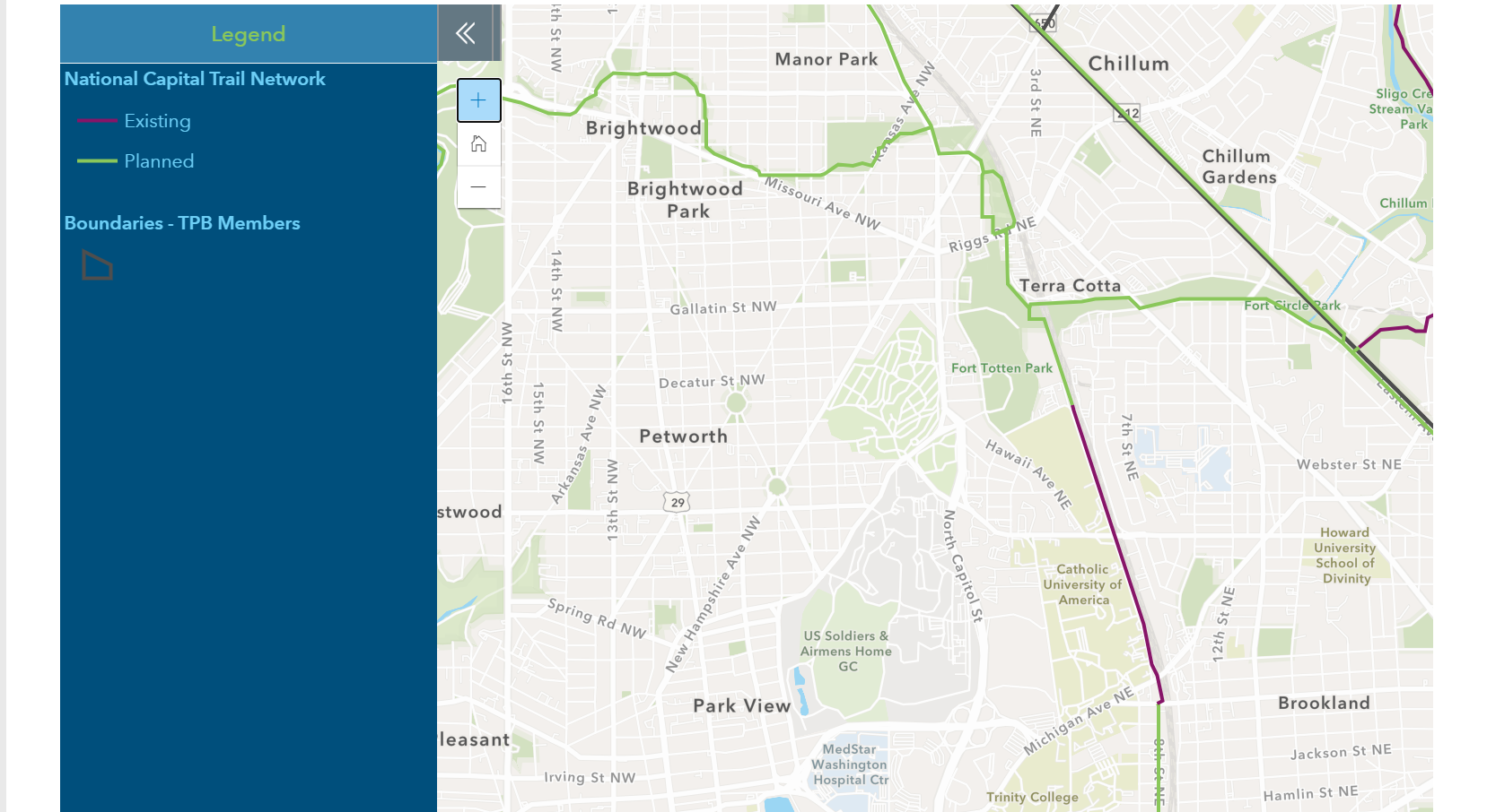
Neighbor Gavin Baker sent me an article from DCist regarding the approval of the National Capital Trail Network. Last week, the National Capital Region Transportation Planning Board, an arm of the regional Metropolitan Washington Council of Governments, approved the trail network via a board resolution. The plan includes a paved trail near/through Fort Circle Park, connecting to the Metropolitan Branch Trail near Fort Totten, and a trail along Eastern Avenue. The Fort Circle Park trail (named as a part of the Met Branch Trail) was previously included in the District Department of Transportation’s moveDC plan. The resolution calls for annual progress reports and priorization for funding for the trail network.
The District Department of Parks and Recreation (DPR) is undertaking a 20-year master planning effort called Ready2Play DC. Information is available at https://ready2playdc.com. There you will find links to FAQs, surveys, and meeting information. Importantly, this effort is not just for DC/DPR-owned parks and centers. It will also address National Park Service (NPS) parkland, of which we have plenty in this community. The first priority in the planning process is the Statewide DC Statewide Comprehensive Outdoor Recreation Plan (SCORP). The SCORP project page states:
As part of this Master Plan process, DPR will be drafting and submitting a new Statewide Comprehensive Outdoor Recreation Plan (SCORP) to the National Park Service. This SCORP is a requirement of the Land and Water Conservation Fund (LWCF) Act. It is a 5-year planning document that sets high-level goals and a prioritizing framework (called the Open Project Selection Process) for how DC will select future projects to be submitted for LWCF matching grant dollars.
Over the years, there have been efforts to get traction behind implementing elements of the neighborhood’s adopted area development plan related to green space in the neighborhood. In 2017, ANC 5A passed a resolution that I helped draft to preserve the green space in front of Food & Friends for neighborhood recreation. On this blog, I have cataloguedefforts regarding the NPS parkland at South Dakota Avenue and Galloway Street NE (formally known as the Civil War Defenses of Washington; informally known as Fort Circle Park). I personally submitted comments during the Comprehensive Plan process and budget process to advocate for a two-phase approach for the NPS parkland, starting with a paved trail around the perimeter of the park and adding amenities from there. Ward 5 Councilmember Kenyan McDuffie included funding for an environmental impact assessement of a paved trail at Fort Circle Park in his budget request letter to the mayor before she submitted her budget to the council.
As a neighborhood, we can all bolster these efforts by submitting comments during the DPR master planning process noting that these efforts are all in alignment with the neighborhood’s area development plan. (Aside: Before anyone asks, I am not that concerned about dog parks because a dog park is part of the plan for the second phase of Art Place at Fort Totten). And you can also share whatever other comments you may have regarding recreation in the neighborhood or DC in general. Please take a moment to participate by adding your comments at the Ready2play site or participating in an upcoming community meeting.
Earlier this week, I received an email from DPR stating the agency has awarded a design-build contract for a new playground at Riggs-LaSalle Recreation Center (501 Riggs Road NE) that will be located on the Nicholson Street NE side of the center. The existing playground was reopened to the community last year after being closed to the public for several years. During the time we were working to get the playground reopened, there were discussions about getting a new playground because there seemed to be a general consensus that the existing playground could be much better. Eventually funding became available for a new playground. There will be a community meeting scheduled in the upcoming weeks to review initial concept ideas and to gather community feedback on what residents would like in a new playground. Project scope, timeline, and community impacts will also be discussed. That is all of the information I have right now. I do not know if the idea is to supplement the existing playground with additional amenities or what. So stay tuned for information on when that meeting will be scheduled and start thinking about what you would like to see in a playground at Riggs-LaSalle Recreation Center.
Thank you to all the neighbors who have expressed interest and shared thoughts on reactivating the National Park Service (NPS) Civil War Defenses of Washington (CWDW) parkland in our neighborhood (see these posts from October 2019 and December 2019 for more). This is the Fort Totten Park site bounded by Galloway Street NE, South Dakota Avenue NE, and Gallatin Street NE, between Riggs Park and North Michigan Park.
I have shared your feedback and enthusiasm with folks from NPS and they agreed to participate in a community discussion on this topic. Our original target date for this meeting was cancelled due to the COVID-19 emergency and will be rescheduled for when the stay-at-home orders are lifted and we can safely gather again in public. An online/virtual meeting would not be optimal.
This meeting is expected to be similar to an event NPS held last September with the community near Fort Reno. For instance, an NPS park ranger will take us on a historical tour of Fort Totten, describe its role during the Civil War, and its life since. We will then move to hearing about the CWDW management plan, which is the guiding document that will help us better understand what is possible at this site. NPS will share what projects are currently underway or planned, such as wayfinding and historical marker signage, paving the long-awaited social trail, picnic pavilion improvements, and nearby trash mitigation efforts to restore the Anacostia River. It will conclude with NPS hearing directly from us on ways we would like to reactivate and use this CWDW site more for recreational, historical, educational, and cultural purposes, which are allowable under the management plan. Everybody in the community, from residents, to business owners, local developers, The Parks Main Street, civic leaders, and elected officials are welcome to attend.
It is important to note that “reactivation” here does not mean commercial development. Both NPS and the community recognize the importance of keeping an open green space in our neighborhood. This is an opportunity, though, to have us come together with NPS to identify ways to better utilize this public asset for the community.
My NPS colleagues and I will have standing monthly meetings to prep for this event. During these meetings, I’ll relay comments from the community related to the nearby CWDW parklands and report back with answers. So, if you have questions and/or ideas on what to expect at the NPS community meeting to reactivate the parkland, scheduled construction projects, beautification, habitat restoration, etc., please share them with me in the Comments section below or via direct email here.
Finally, some more good news on this site. NPS informed me that the following projects have made progress over the past few months:
Issued a contract to construct the paved and lighted trail between Galloway Street and Gallatin Streets NE. Construction should start later this spring or early summer, and is scheduled to be completed by the end of September.
Authorized the District’s Department of Transportation to start construction of the section of the Metropolitan Branch Trail that goes over the Metro green and yellow line tunnel at Fort Totten metro station. Construction should ramp up significantly in the coming weeks.
Ward 5 Councilmember Kenyan McDuffie submitted a letter to Mayor Muriel Bowser with his Ward 5 budget priorities. The letter incorporates feedback from residents in response to his budget engagement survey. I hope you had a chance to fill it out.
There are generally applicable items that would benefit large areas of the ward, such as around housing, public safety, and support for small businesses. One item in the letter specific to the neighborhood is a request for funding to assess the environmental impact of a paved trail around Fort Circle Park (formally known as the Civil War Defenses of Washington) at South Dakota Avenue and Galloway Street NE.
Based on feedback from residents, we can accomplish this through additional funds to activate a historic trail for the Trinidad community, and for an environmental impact assessment to examine the possibility of a paved park around Fort Circle Park at South Dakota Ave & Galloway Street, NE, and invest funds for upgrades to play surfaces for all Ward 5 playgrounds. I am also requesting funds to preserve green space and pocket parks in neighborhoods with limited green space such as the Brookland Green.
A trail and play areas around the perimeter of the park is an item in the neighborhood’s area development plan, which was approved by the DC Council in March 2009. In 2016, a nine-year-old Riggs Park resident named Lucas collected signatures for a petition to National Park Service (NPS) and testified at NPS townhalls in support of a playground and trail at Fort Circle Park. Blog contributor David Kosub has beenwriting about efforts to consolidate community action in support of amenities at the park. The Lamond-Riggs Citizens Association has a community benefits agreement with developer EYA to assist with visioning for activation of Fort Circle Park (as well as the District-owned green space in front of Food & Friends). So there is widespread support for a trail at the park, at a bare minimum. I think a two-phase approach might make sense: (1) get a trail; (2) get other stuff. We know anything involving NPS takes time. Funding for an environmental impact assessment would be a really good start and it is something we as a community should actively support.
Congresswoman Norton’s district office is hosting its third quarterly meeting of D.C. residents and representatives of the National Park Service in order to better understand the issues that constituents are having with national parks in the District.
The pertinent details are below:
Who: All D.C. Residents What: Quarterly National Park Service Meeting Where: Cleveland Park Library Meeting Room, 3310 Connecticut Ave NW When: Thursday, January 30, 2020 Time: 6:30 pm-8:00 pm
It’s a new year, and with that comes new opportunities to connect with your neighbors and friends all around you in the community. So, what are we waiting for? Let’s gather up already!
What: Thirsty Third Thursday Neighborhood Gathering
When: Thursday, January 16, 2020, starting around 6:30 pm
Where: Hellbender Brewery – 5788 2nd St NE. We’ll likely be around a circle table – just ask for Thirsty Third Thursday peeps
Who: Everybody is welcome. That includes you (yes, even you!), your family, your retired neighbor down the street, block captains, that new person who just moved in yesterday, folks with hidden agendas, your friend visiting from out of town, and all those babies who have recently entered the world (they know who they are)
Why: Because it’s fun to get to know folks living around you and share stories, unwind, support a local business, and there may even be some trivia too!
Never been to a Thirsty Third Thursday Neighborhood Gathering before? Well, don’t let that stop you now! It’s totally chill, welcoming, and a good respite from the workday.
In response to my October post, I was pleased to see so much interest related to the Civil War Defenses of Washington (CWDW) National Park Service (NPS) land in our community. I summarize the comments below and also describe what’s happened since. This is also a call for helping hands. Volunteers welcomed! Please note in the comments and send me an email on how you, your family, and your neighbors can help this project continue to gather steam.
Dusting Off the Plans
To know where we are going, we must look back to where we have been. The 2009 Riggs Road and South Dakota Avenue Area Development Plan generally calls for connections, reactivation, and the creation of open spaces around us (see Implementation Table 4.3). It also calls for establishing additional recreational opportunities in the green spaces. Let’s achieve these goals already!
Funding is referenced coming from the District’s Capital Improvement Budget and Capital Space Plan, such as for “active recreation, such as … trails at the edges of the Fort Circle Park near residential areas.” The Capital Space Plan provides strategies for parks, particularly those in the city’s neighborhoods, to create a beautiful, high-quality, and unified system for the Nation’s Capital. I doubt funding is available anymore, but are there any volunteers out there to look into this possible revenue source?
Trees, Trees, and more Trees
I was glad to see I’m not the only tree hugger in the neighborhood. We can always use more trees. Folks seem to echo the point that, without shade trees at least on the perimeter of the park, the area can get too hot during certain times of the year and thus become unusable for many (see this heat island map published last year noting our community is one of the hottest spots in the city). Moreover, trees help combat the effects of climate change, cool the roads, help with stormwater management, provide new habitats for the other creatures around us, give shade for folks who are taking in a pick-up game, and beautify the surroundings making this a more pleasant and desirable place.
During a recent follow-up conversation, NPS acknowledged the community’s desire to have more trees along the edges to help combat the heat island effects and provide shade for park visitors. They still stressed the point that the large swath of open green space in the middle must be maintained in accordance with the management plan for these parklands. That said, they are going to consider the option to plant trees along the perimeter and step up the effort to replace known dead or dying trees.
As suggested, I also reached out to Casey Trees about this site. They noted not working much with CWDW parks before, but were thrilled we want to utilize the land more effectively, such as by adding trees. The likely next step is to submit a Community Tree Planting application so their arborists can take a look and see if moving forward is feasible. Any volunteers to submit the application?
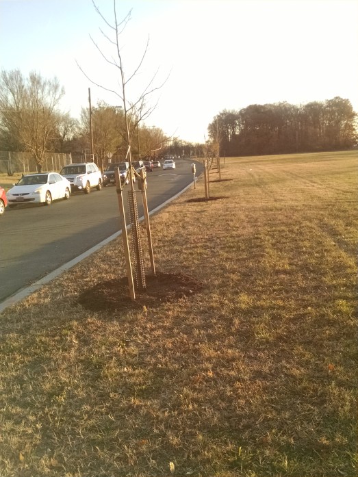
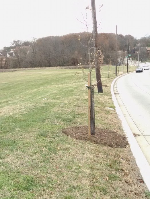
Interestingly enough, roughly 30 new trees were recently planted along the perimeter of the park on the Galloway Street side from South Dakota Avenue to 11th Street NE. Trees were also planted on the perimeter of the park east of Sargent Road NE on Galloway and Gallatin streets. It is unclear to me if these tree plantings were a result of my discussions with NPS, but they are most welcomed nonetheless.
Newly planted trees on Galloway Street NE
Newly planted trees on Gallatin Street NE
To Be Fit or Not to Be Fit
This NPS site is zoned for recreational purposes. And, to many, this means opportunities for exercise. Be it a walking or running path lined with markers, exercise equipment, and a designated field for sports and play for humans and our four-legged friends, we are ready to have fun! Any volunteers to organize a group yoga class or begin an annual Riggs Park v. North Michigan Park pick-up game, perhaps at the next Fort Circle Field Day?
NPS will not approve a designated dog park or install a water fountain (see this 1992 Washington Post story for other wishlist items which would not fly either, but hopefully we will have better neighborhood buy-in today). Other community suggestions are still possible. A walking trail could be installed, as it aligns with earlier NPS plans. But it’ll be costly, and the community would need to find the funding source (I’m looking at you, the District’s Capital Improvement Budget). For such a trail to be installed, environmental and geotechnical studies must be done, ensure it fits the historical and cultural aspects of the park, and professional designs must be obtained. The estimated cost would be around $250,000. The best option here would likely be having the District and local developers pony up the funds. With enough community support, this could be possible. It’s budget planning season after all.
Infrastructure
Perhaps those resources could be used elsewhere though. The pavilion area needs some TLC. Many neighbors noted its lack of accessibility and that it could be spruced up with picnic tables and natural shade. NPS indicated rehabbing the picnic and pavilion area is doable, including adding a grill. Some things could happen quickly, like bringing in some picnic tables, while others may take a couple years, such as renovating the picnic shelters and making them ADA compliant. NPS is currently in the process of requesting funding.
As for other infrastructure needs, such as lighting and sidewalk improvements, we likely need to reach out to the District’s Department of Transportation through 311 requests. Volunteers are welcomed to start submitting these requests today.
Historical markers
Historical markers for CWDW parks are on the way. NPS has submitted designs for approval from the Commission on Fine Arts. The Commission will discuss these interpretative signs at their upcoming spring 2020 meeting (renderings will be shared once available). I hope these markers add a nice piece of visual flair to the neighborhood.
Next steps
I feel like we are making progress. NPS is happy to partner with us, which does achieve one of the goals from the plans referenced earlier. One event NPS mentioned was teaming up with a group on the Maryland side already engaged with them for a spring clean-up event. And, since the community has expressed concerns related to trash in the park, perhaps additional resources could be provided to the South Dakota Ave Clean Team? I also spoke with a representative from the Cafritz Foundation and they expressed interest, general support, and a willingness to partner too. The Parks Main Street has some ideas too, and if they come to fruition, I think the community will enjoy them (yes, that is a teaser).
To reiterate though, I need your help. If we want resources to flow into this park, we need neighbors to stand up and volunteer their time. Would you consider attending a community meeting in January or February? We could bring NPS in, along with inviting local community groups, developers, and District government representatives. It would be great to hear your ideas in person. Raise your hand if you would attend, and I will put a meeting on the calendar.
Remnants of an earthen fortification exists right in Riggs Park’s backyard. Constructed from the surrounding ground, it helped protect the District of Columbia from invasion from from Confederate soldiers during the Civil War. Oh, how times have changed.
When going through the neighborhood today, we may not even give it a second thought. We may now only think of the area surrounding Fort Totten as a main transportation hub, an urban forest, and an open field adjacent to South Dakota Ave NE. But, could it be something more?
Originally known as the Fort Circle Parks, the Civil War Defenses of Washington (CWDW) (of which Fort Totten is a part) are a unique National Park System (NPS) asset located very close to home. In 2004, NPS released a plan to manage and preserve the circle of forts, with a particular focus to “preserve significant natural features, including substantial acreage of mature native hardwood forest, geologic and aquatic resources, and a diversity of important habitat for indigenous flora and fauna that are unusual in an urban setting and that contribute to the uniqueness of the nation’s capital.” In addition to natural preservation, it also called for enhancing knowledge on the forts’ cultural significance to the Civil War and encouraging recreation.
Let’s work as a community now to finally achieve these 15-year old goals for our slice of the CWDW. Following the enactment of the public lands package of bills earlier this spring, the District of Columbia and NPS can now enter into agreements to maintain and operate NPS properties in the District. See this post here for more.
With assistance from the office of Congresswoman Eleanor Holmes Norton (D-DC), I recently spoke with NPS about this issue, with a focus on reactivating the parcel of CWDW parkland bounded by Galloway Street, South Dakota Avenue, and Gallatin Street NE. Generally speaking, they appear willing to help, but we must work within the framework on the CWDW management plan. For instance, this area is zoned as “recreation” meaning open green space must be preserved, and “organized and informal recreational activities will be the primary use.” Thus, picnicking, pick-up games, community events, and the like are allowable, but things like playgrounds and water features which distract from the historical nature are not.
So, how would you like to use this space? Add your thoughts to the comments section or send me an email here. I’ll synthesize the ideas and share back in a follow-up post.
As a start, NPS threw out the following suggestions. They previously approved a multi-purpose trail to be installed, but this will be a timely and costly endeavor, one for which funds are not available. They could reinstall and enhance the picnic area with new tables, trash cans, grills, roof features, and even a composting toilet. However, they noted that the community has raised concerns previously related to potentially nefarious and illicit activities when picnic tables used to be there (see this caught on camera footage).
Programming with NPS events is possible too. The 2004 plan calls for the activity center at Fort Dupont to be transformed into a center educating the community on the cultural history and natural resources within the CWDW. This center, according to the plan, will help “schools within walking distance of the fort sites to use these areas as local outdoor classrooms for cultural and environmental education.” Perhaps our local schools and library educational activities could benefit from this?
Wayfinding signage would be great to help passersby know more about this national park. Such signage could explain the landscape and its historical importance. The plan also indicates that “signs, site furniture, and interpretive materials [were to be purchased] as a way to make the [CWDW[ more visible.” When we spoke, NPS appeared amenable to this idea as the 2004 plan talks about how markers are helpful to create a consistent interpretation of the cultural significance of the CWDW.
I also would love to see more trees around the perimeter of the site. That said, I recognize the call for maintaining the character of the large swath of open space in the 2004 plan, but trees provide many tangible benefits to a community that I feel they cannot be overlooked. NPS was hesitant about planting more trees around the perimeter, but they did not completely shut the door on the idea.
Finally, the plan does recognize the “need for visitors to be safe while in the parks. NPS indicated the design for a paved trail between Galloway and Gallatin is underway and will share information upon its completion. Congresswoman Norton is also aware of this community concern (see here).
We have a great opportunity as a community to engage with this space. The Parks Main Street (on whose Board I serve), aims to revitalize the Riggs Park small business corridor. This could be facilitated through creating historical markers, hosting promotional events, and securing resources to beautify the visual character of the nearby parkland adjacent to the neighborhood. Perhaps since the Lamond-Riggs Citizens Association approved the Community Benefits Agreement with EYA for the Fort Totten South project this past June, we could use future promised “funding [as noted in the agreement] to complete improvements or upgrades . . . following [in-kind design services and a minimum of three visioning sessions . . . [for the] activation of Fort Circle Park.” (Read more on this agreement here). Maybe ANC 5A could invite NPS to an upcoming meeting to hear directly from the community on this issue (building on Congresswoman Norton’s offer a couple weeks back to help bring NPS here for a community discussion). Call me a dreamer, but maybe all three could combine forces on this too. Either way, your ideas are welcomed in the comments section below or via email to me directly.
August 6, 2019 National Building Musuem Ward 4 Day 9:00 am-11:00 am National Building Museum 401 F Street NW Bring photo ID with zip code
MPD 4th District National Night Out 5:00 pm-9:00 pm Riggs-LaSalle Recreation Center 501 Riggs Road NE
August 9, 2019 Fridays at Fort Totten Concert Series: The JoGo Band 6:00 pm-8:00 pm South Dakota Avenue & Galloway Street NE Bring a lawn chair for seating. Sponsored by The Modern at Art Place & On Tap Magazine
August 10, 2019 Bertie Backus Farmstand 10:00 am-2:00 pm UDC-CC Backus 5171 South Dakota Avenue NE
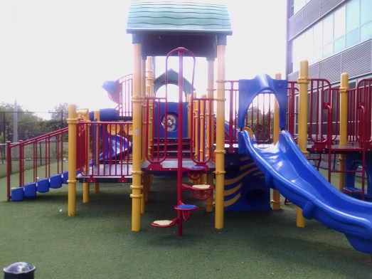
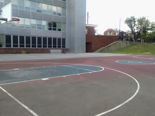
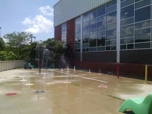
The community playground, tot lot, and basketball court at Riggs-LaSalle Recreation Center (501 Riggs Road NE) are open again after several years of being closed to the community. The splash park is functioning as well. These are community spaces, and we as a community need to make sure they are being used for community purposes. Employees from the mayor’s office and DPR staff have done a good job addressing issues regarding individuals using the rec center for antisocial, non-community purposes. If there are any issues with accessing the playground or if any public safety concerns arise, please let the rec center staff know.
Fridays at Fort Totten Concert Series featuring music by Allthebestkids and Carnivore BBQ food truck. 6:00 pm, corner of South Dakota Avenue & Galloway Street NE. Bring a lawn chair for seating
June 29, 2019
DDOT Rock Creek East I Livability Pop-up: Share your views on how to make the transportation network safer and more accessible. Study area is defined by Rock Creek and the Maryland border to the West, Eastern Avenue to the North, New Hampshire Avenue NE and the Red Line Metrorail tracks to the East, and Military Road NW, Missouri Avenue NW, and Riggs Road NE to the South. 10:00 am-12:00 pm, Safeway, 6500 Piney Branch Road NW
Explore! Jumpin’ July Community Festival featuring petting zoo, music show, science show, coloring, storytelling, face painting, and more. 10:00 am-1:30 pm, The Modern at Art Place, 400 Galloway Street NE
Come one, come all! Let’s have some fun playing in a National Park in our backyard!
What: Fort Circle Field Day
When: Saturday, May 18, 2019, starting around 12:00 noon
Where: We’ll be set up somewhere on the grassy field at Fort Circle Park bounded by South Dakota, Galloway, and Gallatin NE
Who: Everybody is welcome! Tell your neighbor of 40 years across the street and the one who just moved in next door. Tell your friends in Lamond-Riggs. Tell your family in North Michigan Park. Tell your buddy in Manor Park. Tell your puppy we’ll have a yappy hour. Tell the 96 Bus driver, but they may look confused.
Why: Because who doesn’t enjoy just hanging out in the park, meeting some new faces, playing a couple field games, drinking some lemonade, taking in nature, strumming a guitar and thumping a drum, and watching puppies catch frisbees
This is a totally low-key social event. Come and go as you please. Bring some musical instruments. Bring some balls. Bring a lawn chair. Bring some SPF 40. Bring your grandma’s homemade sweet potato pie. And, don’t forget to bring grandma too.
Please spread the word to folks far and wide. Let’s begin reactivating Fort Circle Park for the benefit of our community!
On March 12, 2019, President Trump signed a bill on a federal lands package that may have direct implications for activities in the Lamond-Riggs neighborhood. The bill (S. 47), entitled the “John D. Dingell, Jr. Conservation, Management, and Recreation Act,” sets forth “various programs, projects, activities, and studies for the management and conservation of natural resources on federal lands.”
According to a press release after Senate passage from Congresswoman Eleanor Holmes Norton (D-DC), who sponsored one of the bills in the package, the legislation clarifies that “the District of Columbia and the National Park Service (NPS) have the authority to enter into cooperative management agreements (CMAs) to maintain and operate NPS properties in the District.” The release quotes Holmes-Norton saying the bill would “allow D.C. to work with NPS to maintain and improve the many NPS-owned parks here in the nation’s capital.”
Franklin Park, one of the many NPS-owned parks in the District, is now on track to proceed more easily with a public-private partnership for its planned rehabilitation now that the bill is law. A case study in real-time (Read more here).
This is very interesting and exciting news to me, and it should also be for my Lamond-Riggs neighbors. There are many items on our wish-list for safety and recreational improvements to the national parks around us—Fort Circle Park and Fort Totten Park. Let’s use this new authority to help address our interests too!
Residents in the Fort Totten neighborhood have also expressed concerns related to safety using the trail on the other side of Fort Circle Park west of the metro station, which will become part of the Metropolitan Branch Trail very soon. The primary concern revolves around personal safety, especially at night, because of burnt out lights that have not been replaced. However, despite having this issue raised at countless ANC and other neighborhood meetings, DC officials and Metro police have voiced their own concerns related to working collaboratively with NPS in the past. Our neighbors should not feel scared to use this public asset when simply attempting to walk to and from the metro.
On the lighter side of life, these national parks in our backyard are underutilized for more leisurely pursuits. As a nine-year-old resident in Riggs Park wrote in a 2016 petition, additional resources for amenities in Fort Circle Park, like a paved trail and playground, would afford us a “place to get together, exercise, and for us to play and ride.” Nearly 240 neighbors agreed with him that an enhanced trail is desired, would complement the forthcoming Children’s Museum, as well as allow the “children and adults a safe place to walk, jog, or bike ride.” Moreover, I’m still open to the idea of Fort Drum Circle too, perhaps coming this spring or summer. And, did I hear someone say dog park? All in all, it would be great to see city investment here to help improve these public lands for recreational and historical purposes, while balancing that with conserving the precious green space we’ve all come to enjoy.
I recognize much still needs to be done to see these, and other, wish-list items come to fruition. It takes a village after all, naturally working together in a strategic, rational, civil, and non-conspiratorial manner. Perhaps as a start, we could get a representative from the Franklin Park project to speak at a neighborhood meeting about their best practices and lessons learned, which we can then apply to receive city funding to directly revamp our park. Maybe we can engage our local small businesses, neighborhood developers, UDC Backus friends, and the Main Street organization to help sponsor more projects that can activate these public resources. Encourage our youth to speak with elected officials again as Fort Circle Park Ambassadors? Or, a neighborhood yappy hour with our four-legged friends is in order? Let’s hear your ideas too!
Today at 11:00 am, join the National Park Service for a hike of Fort Totten. Meet at the Fort Totten metro station entrance.
DESCRIPTION
Join the Civil War Defenses of Washington (CWDW) for an exploration of Fort Totten, one of the 68 major forts that encircled Washington DC during the Civil War. The fort saw action during the Battle of Fort Stevens in July 1864 and is one of 17 sites preserved and managed by the National Park Service.
Ranger Steve T. Phan will guide visitors in and around the historic earthen fort, including recently discovered remnants thought to be lost during the post-war era.
Meet Ranger Steve at the entrance to the Fort Totten Metro Center.
The 1.5 mile hike and will be conducted over paved sidewalks, dirt paths, and grass. Visitors will be guided back to the metro station at the conclusion of the tour.
Fort Totten Metro Center Address: 550 Galloway St NE, Washington, DC 20011
Take my survey to tell me what you think, or read on for more
information.
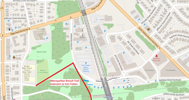
The Metropolitan Branch Trail (MBT) is a multi-use trail that will run from Silver Spring to Union Station when completed. Today, the trail segment connecting Fort Totten to the south is under construction and expected to open in 2020. When it opens, Lamond-Riggs and adjacent neighborhoods will have access to a great facility for walking, jogging, and biking. To access the MBT, the Fort Totten trailhead will be located on 1st Place NE, just west of the Fort Totten Metro station. The trailhead will connect to the sidewalk network, as well as the trail spur that connects west to Gallatin Street NE (which will be repaved as part of this project).
Overview map of the area, including approximate location of the new trail
But for those of us who live in Lamond-Riggs, the question
is: How are you going to bike there?
Bicycling is one of the primary purposes of the MBT, whether for recreation or commuting. However, Lamond-Riggs currently has no bike facilities, other than a single bike lane on Kansas Avenue, a mile away from Fort Totten. (Michigan Park and North Michigan Park also have no bike facilities.)
Biking on sidewalks is legal in this area, but not
recommended. (Bicyclists on sidewalks have to yield to pedestrians, and are at
greater risk of being struck by drivers at road crossings.)
Since there are no bike facilities and we don’t want to bike on the sidewalk, then that leaves biking in the street. Four streets provide access to the Fort Totten trailhead from Lamond-Riggs: Riggs Road, Galloway Street, Ingraham Street, or Kennedy Street (via 3rd Street). Riggs Road is a difficult option for cyclists because of high traffic speeds and volumes, so let’s look at the others. Galloway, Ingraham, and Kennedy streets all share another challenge for bicycling: a big hill. The climb on Galloway Street from South Dakota Avenue to the Fort Totten trailhead is comparable to Meridian Hill! I’ve watched many bicyclists humping up that hill, and none looked like they were having fun.
Up a big hill
Route
Distance
Climb
Incline
Galloway Street NE from South Dakota Avenue to the Fort Totten trailhead
2,255′
85′
3.8%
16th Street NW from U St. to Euclid St. (Meridian Hill)
2,284′
85′
3.7%
(Data from Google Maps)
Of course, that hill is exactly why Fort Totten is where it
is: to have a commanding view of Confederate advances. While that topography
served the Union Army well, it’s not so great for a leisurely ride.
Combine topography with traffic and this will be a frustrating spot. Drivers don’t want to be behind an exhausted bicyclist going uphill . . . and that bicyclist doesn’t want to be in front of drivers. Notably, Galloway Street is the route for several Metrobuses, as well as parking and kiss-and-ride for the Fort Totten Metro station.
The MBT is meant to be enjoyed by people of all ages and
ability levels. But under the current conditions, reaching the MBT by bike from
Lamond-Riggs may be an unpleasant experience for many people.
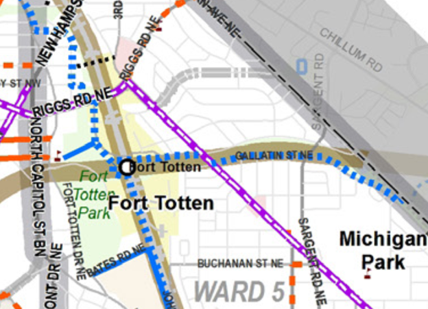
However, there may be opportunities to make some improvements so our neighborhood can have better access. There have been various plans for bike facilities on or next to Galloway Street. The District Department of Transportation’s (DDOT) 2014 moveDC plan includes a future trail along Galloway St. from the Fort Totten trailhead to South Dakota Avenue. That trail segment would continue along Gallatin St. to the District line, to a connection with the Northwest Branch Trail in Maryland. If built, that segment would connect our neighborhoods to many more miles of trails. However, at this time there seems to be no concrete plan for building it.
2014 moveDC plan. Blue dotted lines indicate a planned trail
More modestly, last year DDOT listed a climbing lane as a “possible 2018 installation” on the lower portion of Galloway Street, from South Dakota Avenue to 4th St. NE (the alley through the Modern). A climbing lane is an on-street bike lane in the uphill direction only. While that would be a start, bicyclists would still have to mix with vehicular traffic the rest of the way uphill, and all the way downhill from the trailhead. More to the point, 2018 is now over and it didn’t happen yet. (However, the recent February Lamond-Riggs Citizens Association, a DDOT representative said that the planned sidewalk would be installed on the south side of Galloway Street in this location some time in 2019. Maybe the sidewalk and the bike facility are related?)
Looking north, the Cafritz Foundation’s Art Place development sits between Ingraham and Kennedy streets. Maybe new bike facilities could be built as part of any transportation changes arising from that development. In fact, the developers have stated that they would like to realign Kennedy Street in a future development phase. Realignment would involve new paving and curbs: if appropriate, maybe new bike facilities could be included.
These are some of the issues and ideas as I see them. How about you? Take my survey to tell me what you think, and let’s work together to find solutions for our neighborhood. If folks respond to the survey, I’ll share the responses out with the community.
Like Dracula, it’s ready for a tasty drink. Like the werewolf, it’s howling for you to be there. Like Frankenstein, the combo of ingredients in the batch are alive. Like the Mummy, there’ll be paper towels to sop up any spills. And, like a zombie, it has raised back up from the dead (well a two-month hiatus at least).
That’s right! The Thirsty Third Thursday Neighborhood Gathering has returned! What are you waiting for? C’mon out and have fun with all of us. Don’t be scared!
What: Thirsty Third Thursday
When: Thursday, October 18, 2018 at 6:30 pm
Where: Hellbender Boo-ewery – 5788 2nd St. NE
Why: because we want to show off our costumes before Halloween
Pump up the kin. Dig up some friends. Scare up a neighbor or two. Let’s have some fun!