

In this post, I shared the tentative final map that the Ward 5 ANC redistricting task force created. The task force will vote on the map today at 6:00 pm. Meeting agenda here.
More information is available on the Ward 5 ANC redistricting website at https://kenyanmcduffieward5.wpcomstaging.com/ward-5/ward5redistricting.
ANC single member district 5A01
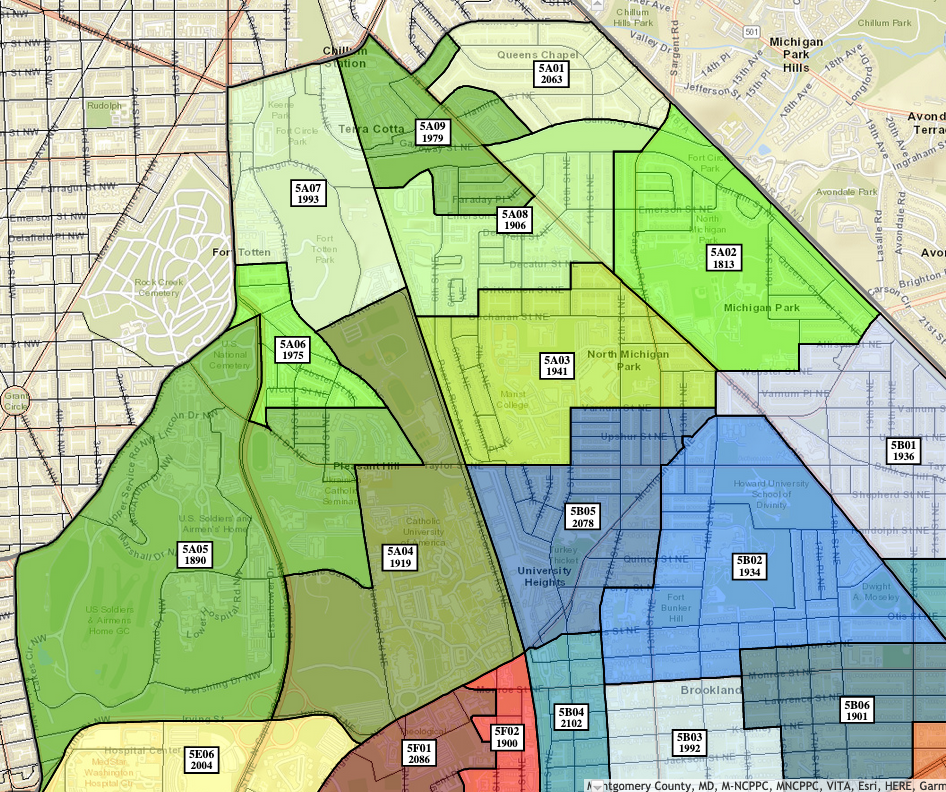
I previously submitted feedback on the task force’s three discussion maps to the effect of (1) keep 5A01 as is; (2) if 5A01 absolutely has to change, keep a sensible grouping of residents on South Dakota Avenue, Galloway, Hamilton, Jefferson, Ingraham, 7th, and 8th together; and (3) keep the residents east of South Dakota together with the residents west of South Dakota. I do not know what other feedback the task force received about 5A01. These were just my thoughts; I am certainly not trying to speak on behalf of all 5A01 residents.
I think the task force attempted to draw a district keeping as much of 5A01 together as possible, but because of the way the streets are designed and the way the census blocks are drawn in this area, the map continues to look strange and not make a lot of sense. You can see a map of the census blocks with populations here.
I continue to believe trying to carve up 5A01 is a fool’s errand (no offense to the task force, they are just trying to do the task they were assigned). The resulting tentative final map is evidence of the futility of this task. In the tentative map, residents on South Dakota Avenue between Hamilton and Ingraham would be in the same SMD as residents in the 400 block of Jefferson Street, but not the same SMD as residents on South Dakota Avenue between Ingraham and Jefferson.
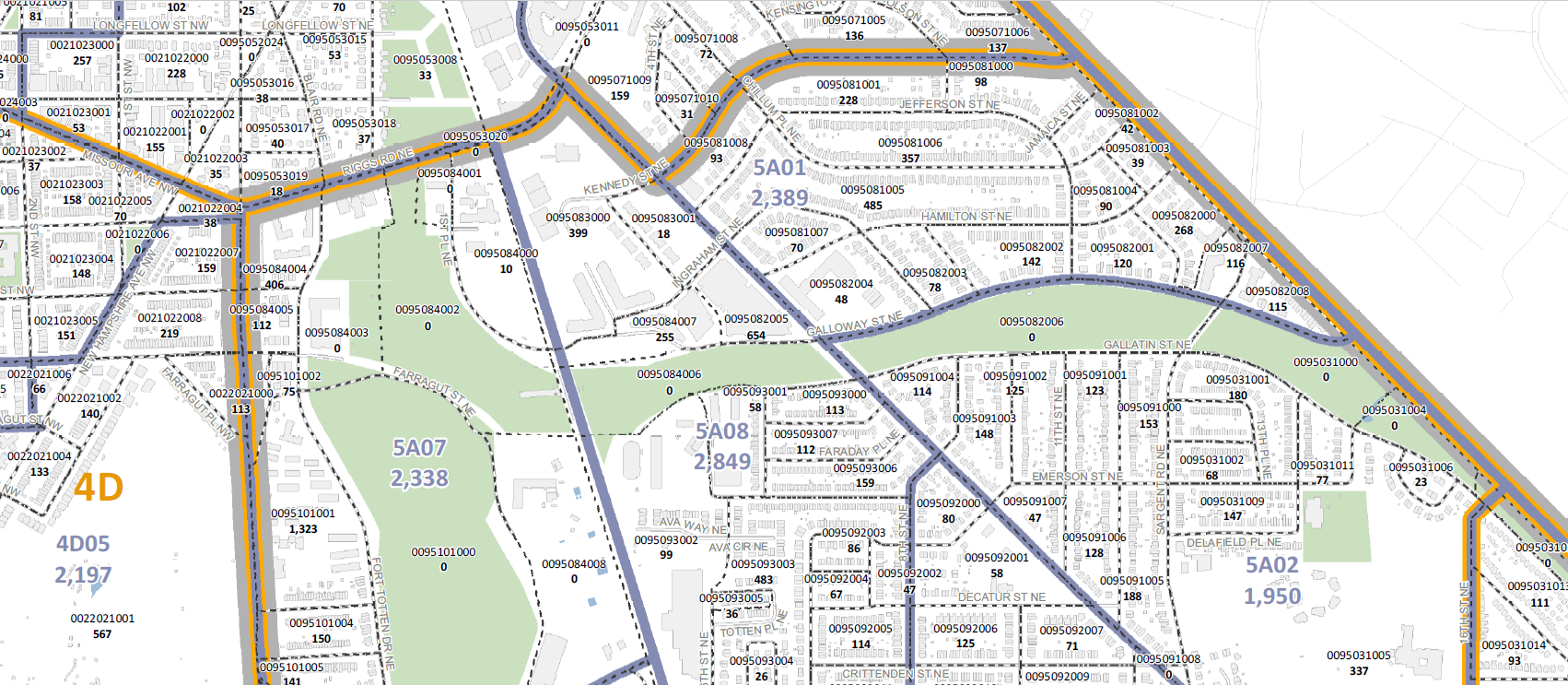
I think the biggest challenge to drawing a sensible map is census block 0095081005, which you can see in the picture below. It is bounded by South Dakota Avenue, Jefferson Street, Chillum Place, Ingraham Street, Hamilton Street, and 11th Street.
Unless there are going to be manual splits somewhere (and not clear where those splits would be), it is not going to be possible in my mind to draw a map that makes sense. So part of my feedback to the task force remains advocating for keeping all of 5A01 together. I continue to believe there is a strong defensible argument for keeping this SMD as is. (1) It is constrained by census geography (very large census blocks covering multiple streets that cannot be easily split). (2) It is constrained by political geography (the Ward 4/Ward 5 and state line boundaries). (3) It has a natural geographic boundary (Fort Circle Park). (4) It keeps a cohesive neighborhood unit intact.
SMD 5A01 started out with 2,139 residents following the 2010 Census. In 10 years, it has grown by a little over 200 residents. I suspect (but haven’t researched) that some of that growth is from families and families with children moving into the area. Because this SMD primarily consists of single family homes with a few established apartment buildings, I don’t think there is a risk that the population will grow so much as to be super problematic for purposes of representation.
The task force is making allowances for SMDs with up to 2,250 residents, but so far they have decided that 2,389 is just too far outside the max limit of 2,100 residents. I don’t fault them for deciding that. I still think there are good reasons for allowing it.
Proposed Amendment to Tentative Final Map for ANC 5A (link)
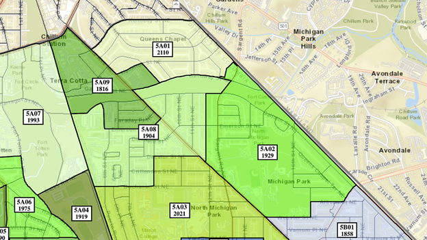
One amendment affecting this neck of the woods will be proposed at the task force meeting tonight by one of the co-chairs, from what I understand. It would shift roughly 48 residents on the west side of 7th Street (the folks who share the alley with UDC’s campus) to an SMD west of South Dakota Avenue. The folks on the east side of 7th Street would remain in 5A01. The residents across the street from UDC’s campus on the north side of the 500 block of Hamilton Street would remain in 5A01.
The amendment would also shift part of the apartment community along Sargent and Eastern to 5A02, which currently sits south of the park. It looks like the apartment buildings sit in three census blocks (census blocks 0095082000, 0095082007, 0095082008), with one of those census blocks sitting across Sargent/Eastern. The amendment is only proposing to shift two of those census blocks out of 5A01, so part of the apartment community would be in a different SMD from the rest, from what I can tell.
Alternative to the Amendment (link)
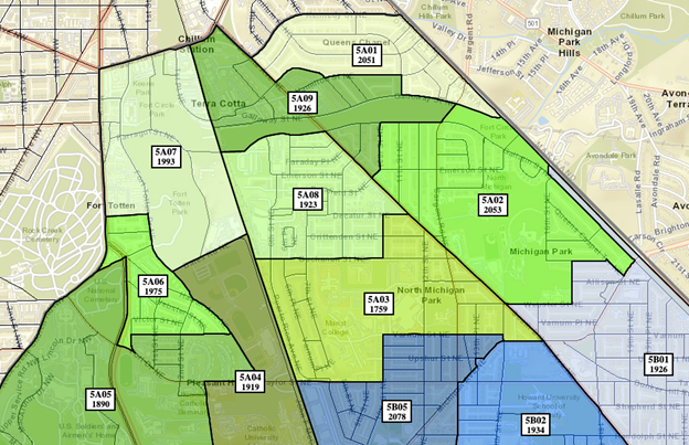
It looks like there is also an alternative to the possible amendment. This alternative is based in part on a map that I shared with the task force as I was playing around with the numbers for 5A01 and 5A08. My thinking was really to take the carveout of 5A01 residents from the discussion maps and group those residents with the other Riggs Park residents directly west of South Dakota Avenue rather than grouping them with North Michigan Park residents catty-corner across South Dakota Avenue. So I drew a partial map focusing on 5A01, 5A02, and 5A08 to see what the numbers might look like. The co-chair played around with those SMDs, plugged in the other SMDs, and came up with this alternative. I do kind of think the alternative (and my conceptual map) suffer from the same problem as all of the other maps though.
Next Steps
The Ward 5 ANC redistricting task force will vote on a final Ward 5 ANC map today. The task force’s report with recommendations is due to the Council on April 1, 2022.
The Council will hold hearings on the ANC maps before they are finalized. The first Council hearing on the ANC boundaries will be on April 7, 2022. Sign up to testify by April 5, 2022. Written comments will be accepted until May 13, 2022. Instructions are in the hearing notice.

The map known as “5A01-5A-5B ALT” appeals to me. I like the changes to my SMD 5A08. I feel like it captures my neighborhood much better than proposed final or other proposed amendment.
You should let the Council know (either testify or submit written comments). It honestly sounded like 5A drew the short straw in this process. A few of the task force members said that only 2 of the people on the 5A subgroup actually took the time to fully participate in the process. Neither of those 2 people live in 5A from my understanding, so I think they just tried their best. But the result was no draft 5A map or discussion of any kind before the discussion maps were released, discussion maps for 5A that didn’t make a whole lot of sense, a tentative final map that tried to make a bit more sense, and then bewilderingly a decision by the task force to support an amendment for 5A that puts one apt community (Michigan Park Commons) in two different SMDs despite my comments letting them know that was what they were doing. And now we get to spend even more of our time writing the same comments to the Council about why this doesn’t make sense. This whole process has been baffling and I really think the Council should utilize professionals who know how to do this stuff rather than relying solely on volunteer residents.