In advance of the April 4th public hearing for a requested first stage modification and second stage review for the Art Place at Fort Totten planned unit development, the development team has provided an updated project overview. View the document here. This information has also been posted on the Lamond-Riggs Citizens Association’s neighborhood development page.
There will be a few opportunities for residents to learn more and share thoughts/concerns about the plans, which were first submitted in September 2018 and refined in January 2019.
February 28: Lamond-Riggs Development Task Force meeting, 6:30 pm, Lamond-Riggs Library (5401 South Dakota Avenue NE)
March 4: Lamond-Riggs Citizens Association monthly public meeting, 7:00 pm, LaSalle-Backus Education Campus auditorium (501 Riggs Road NE)
March 25: ANC 4B monthly public meeting, 7:00 pm, MPD 4D Headquarters (6001 Georgia Avenue NW)
March 27: ANC 5A monthly public meeting, 6:45 pm, UDC-CC Backus (5171 South Dakota Avenue NE)
Lamond-Riggs Citizens Association Public Meeting March 4, 2019 7:00 pm Location: LaSalle-Backus Education Campus (501 Riggs Road NE, enter auditorium on Madison Street)
Agenda * Pepco Capital Grid Project Update * Cafritz Foundation: Art Place at Fort Totten Phase 2
Read LRCA’s March 2019 newsletter at lrcadc.org. Pay membership dues online to support scholarships for neighborhood youth.
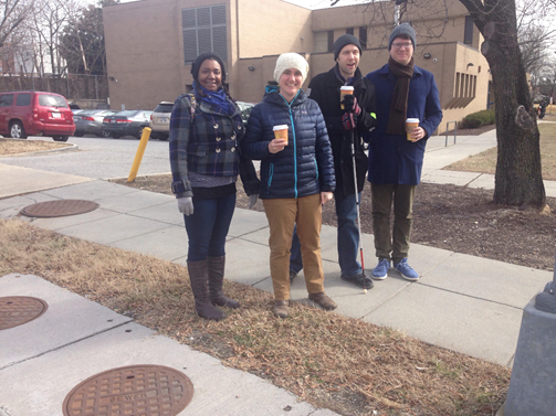
Guest Post by David Kosub, SDA-Riggs Road Main Street Board of Directors
Thanks to all who attended the community kick-off meeting for the South Dakota Avenue & Riggs Road Main Street program. Through this initiative, we aim to organize improvement efforts for the commercial corridors located on South Dakota Avenue and Riggs Road in Lamond-Riggs as well as 3rd Street NW in Manor Park.
For those unable to attend, we presented the scope and goals of the program focused around improving these corridors through streetscape branding and beautification, retaining our small businesses and non-profits in the area, and helping to recruit new ones. Folks also met the community volunteer Board of Directors, newly hired executive director Edwin Washington, and the fiscal sponsor Center for Nonprofit Advancement. Representatives from the offices of Ward 4 Councilmember Brandon Todd and Ward 5 Councilmember Kenyan McDuffie gave congratulatory remarks.
The kick-off presentation is available here for you to learn more.
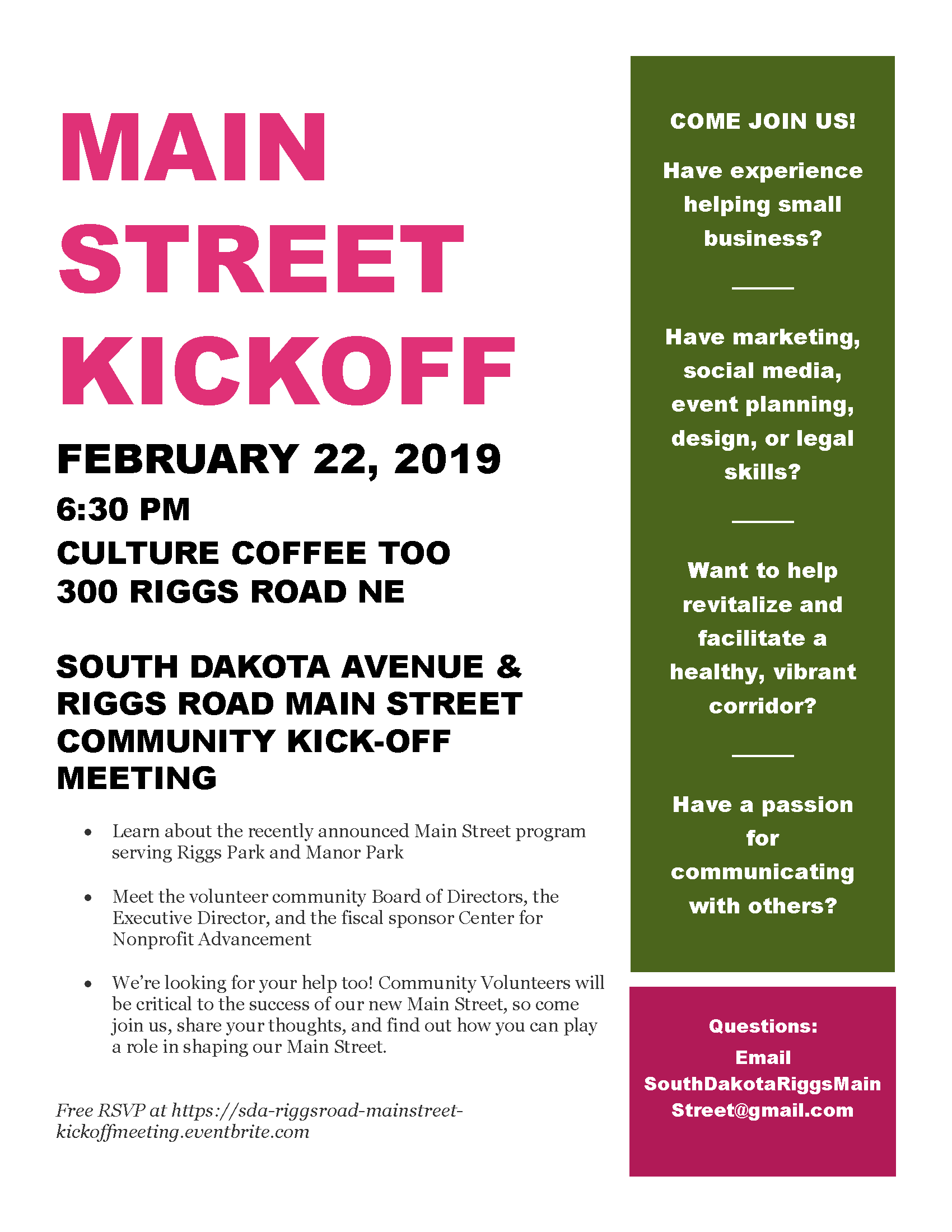
Our new Main Street wants your help. Community members are invited to volunteer their time, expertise, and interest in areas such as small business support, marketing, design and branding, legal, communications, event planning, and more. For this program to be a success, it needs your passion and engagement.
If you would like to volunteer for a specific committee or just want to remain informed as we move along, please fill out the following form here and email it back to SouthDakotaRiggsMainStreet@gmail.com. Everybody is welcome to help, so please join us!
Who: Neighbors, families, friends, business owners, local non-profit leaders, elected officials, community activists, and all others from the Lamond-Riggs, Manor Park, Michigan Park, Fort Totten, and Takoma areas
Why: Because the Main Street wants your support and help
This kick-off meeting will be a great opportunity to meet the volunteer community Board of Directors, the Executive Director, and the fiscal sponsor Center for Non-Profit Advancement
The Board is looking for your help too! Community volunteers will be critical to the success of our new Main Street.
Do you have experience with helping local small businesses grow and thrive?
Do you have marketing, social media, event planning, design, or legal skills to lend to the cause?
Do you have an aesthetic vision for how our communities should look and feel?
Do you have skills organizing community members to achieve a common goal?
Do you want to help revitalize and facilitate a healthy, vibrant corridor that meets the needs of its residents?
Do you have a passion for communicating with and reaching out to others in the neighborhood?
The Board looks forward to seeing you at the kick-off meeting. For questions, comments, or suggestions, please send an email to SouthDakotaRiggsMainStreet@gmail.com
Do you ever wish you could help shape your city’s future? Now is your chance to make your voice heard.
DC Public Library invites you to help us plan our next 10 years.
DC Public Library is developing a Library Facilities Master Plan to help guide planning for library services across the city. Together, we can fine tune and expand library services to remain responsive to the District’s changing and growing needs.
Welcome news: 24 Hour Fitness has signed a lease for a 40,000 square foot gym in the first phase of Art Place at Fort Totten along South Dakota Avenue. It is expected to open near the end of this year or early next year.
Our neighborhood, all tucked away here in upper northeast DC, also lies within the Anacostia River watershed. It regularly reminds me of how connected we are to the rivers in our city. And, this connection is about to get stronger.
Due to the great work of the Lamond-Riggs Citizen Association (LRCA) Environmental Committee, which partnered with the Anacostia Watershed Society (AWS) to obtain a Community Storm Water Solutions grant from the District Department of Energy and the Environment, we will be receiving some new artistic murals around the community very soon. But, don’t look up, look down at your feet. These pieces of visual art will remind us about the state of the Anacostia River and how we must take strides in our own lives every day to keep the river clean. Last year, AWS and LRCA called for artists of all ages to submit designs for storm drain murals. Submissions were judged on their aesthetic strengths and incorporation of an environmental theme. After the community voted on the designs in December, three winners emerged. Let’s meet the winning artists now…
Lovancy Ingram: As a music teacher and amateur artist, she reflects the beauty of her D.C. hometown in her work. Her piece, entitled “Anacostia Water View” received the most votes from the community (11 votes).
“Anacostia Water View”
Elizabeth Sampson: With undergraduate and master’s degrees in the field, she currently lives, creates, and teaches art in the District, where she hopes to use visual art to celebrate positive stories in the world. Inspired by the 2018 Anacostia River Heroes, her mural highlights the role of these hardworking individuals in protecting and restoring the Anacostia River. Particular attention is paid to how their hands work in unique ways to help nurture and sustain a healthy river. Entitled “Jahlil Wormley” with 10 votes, this mural depicts the subject as he catches and releases numerous playfully colored fish, which together represent the importance of imagination as youth work to protect the watershed.
“Jahlil Wormley”
Leila Eguino: A native of Bolivia, Leila completed her undergraduate studies in Art History and Fine Art in Washington D.C. “Crane” received 8 votes from the community.
“Crane”
Look for these murals to be installed on a nearby storm drain come April 2019, just in time for Earth Day. A couple weeks ago, I met up with a group of neighbors, (Olga and Nick) along with Ariel and Stacy from AWS to scope out the perfect installation sites. After considering factors like foot traffic and visibility, the likely best locations found were around the library along South Dakota Ave NE for these welcomed pieces of art.
Neighbors and AWSStacy from AWS pointing to a storm drain near the library
Stay tuned for an opportunity to join the artists in person as they install their murals—bringing a splash of artistic flare to our everyday lives while reminding us of just how connected we are to the health of the Anacostia.
Who: Neighbors, families, friends, business owners, local non-profit leaders, elected officials, community activists, and all others from the Lamond-Riggs, Manor Park, Michigan Park, Fort Totten, and Takoma areas
Why: Because the Main Street wants your support and help
This kick-off meeting will be a great opportunity to meet the volunteer community Board of Directors, the Executive Director, and the fiscal sponsor Center for Non-Profit Advancement
The Board is looking for your help too! Community volunteers will be critical to the success of our new Main Street.
Do you have experience with helping local small businesses grow and thrive?
Do you have marketing, social media, event planning, design, or legal skills to lend to the cause?
Do you have an aesthetic vision for how our communities should look and feel?
Do you have skills organizing community members to achieve a common goal?
Do you want to help revitalize and facilitate a healthy, vibrant corridor that meets the needs of its residents?
Do you have a passion for communicating with and reaching out to others in the neighborhood?
The Board looks forward to seeing you at the kick-off meeting. For questions, comments, or suggestions, please send an email to SouthDakotaRiggsMainStreet@gmail.com
ANC 5A Special Public Meeting
February 20, 2019
6:45 pm
UDC-CC Backus (5171 South Dakota Avenue NE)
Agenda: Wesley Housing – Curb Cut Public Space Application, 1 Hawaii Avenue NE
In case you were not able to make the Lamond-Riggs Citizens Association meeting on February 4, DDOT announced they will install a HAWK signal, a controlled pedestrian signal, at the intersection of Ingraham St NE and South Dakota Ave NE. This is a great step forward in strengthening pedestrian safety here in our community.
DDOT has a handy video explaining how HAWK pedestrian signals work on its website. When a HAWK signal is activated by a push button, yellow lights will flash to warn motorists to slow down for an impending red light. When the light turns red, motorists will be required to stop, just as with traditional traffic signals, to permit pedestrians to cross the street.
Work is expected to be completed around late summer/early fall 2019. We will provide regular updates on DDOT progress as they are received over the coming months.
DDOT committed to take the following actions:
South Dakota Avenue NE and Ingraham Street NE Intersection
Install a HAWK signal in accordance with the MUTCD and DDOT guidelines.
South Dakota Avenue NE and Jefferson Street NE Intersection
Install in-street pedestrian crossing signs (R1-6a) at both sides of crosswalk located at the southbound approach of South Dakota Avenue NE.
Install advanced pedestrian crossing sign (W11-2) along both directions of South Dakota Avenue NE.
Remove the pedestrian warning sign on the northwest of Jefferson Street.
Mid-block (between Ingraham Street and Jefferson Street)
Update redundant parking regulation signs on the eastern side of South Dakota Avenue NE.
Please pat yourself on the back for this outcome. Without your letters of support, many reports to 311 and 911, outreach to elected officials, submitting traffic studies, direct engagement with city agencies, and so much more, we may not be in the position we are today.
Today at 11:00 am, join the National Park Service for a hike of Fort Totten. Meet at the Fort Totten metro station entrance.
DESCRIPTION
Join the Civil War Defenses of Washington (CWDW) for an exploration of Fort Totten, one of the 68 major forts that encircled Washington DC during the Civil War. The fort saw action during the Battle of Fort Stevens in July 1864 and is one of 17 sites preserved and managed by the National Park Service.
Ranger Steve T. Phan will guide visitors in and around the historic earthen fort, including recently discovered remnants thought to be lost during the post-war era.
Meet Ranger Steve at the entrance to the Fort Totten Metro Center.
The 1.5 mile hike and will be conducted over paved sidewalks, dirt paths, and grass. Visitors will be guided back to the metro station at the conclusion of the tour.
Fort Totten Metro Center Address: 550 Galloway St NE, Washington, DC 20011
Take my survey to tell me what you think, or read on for more
information.
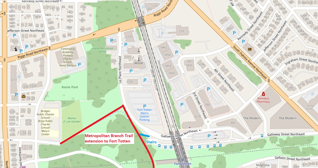
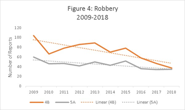
The Metropolitan Branch Trail (MBT) is a multi-use trail that will run from Silver Spring to Union Station when completed. Today, the trail segment connecting Fort Totten to the south is under construction and expected to open in 2020. When it opens, Lamond-Riggs and adjacent neighborhoods will have access to a great facility for walking, jogging, and biking. To access the MBT, the Fort Totten trailhead will be located on 1st Place NE, just west of the Fort Totten Metro station. The trailhead will connect to the sidewalk network, as well as the trail spur that connects west to Gallatin Street NE (which will be repaved as part of this project).
Overview map of the area, including approximate location of the new trail
But for those of us who live in Lamond-Riggs, the question
is: How are you going to bike there?
Bicycling is one of the primary purposes of the MBT, whether for recreation or commuting. However, Lamond-Riggs currently has no bike facilities, other than a single bike lane on Kansas Avenue, a mile away from Fort Totten. (Michigan Park and North Michigan Park also have no bike facilities.)
Biking on sidewalks is legal in this area, but not
recommended. (Bicyclists on sidewalks have to yield to pedestrians, and are at
greater risk of being struck by drivers at road crossings.)
Since there are no bike facilities and we don’t want to bike on the sidewalk, then that leaves biking in the street. Four streets provide access to the Fort Totten trailhead from Lamond-Riggs: Riggs Road, Galloway Street, Ingraham Street, or Kennedy Street (via 3rd Street). Riggs Road is a difficult option for cyclists because of high traffic speeds and volumes, so let’s look at the others. Galloway, Ingraham, and Kennedy streets all share another challenge for bicycling: a big hill. The climb on Galloway Street from South Dakota Avenue to the Fort Totten trailhead is comparable to Meridian Hill! I’ve watched many bicyclists humping up that hill, and none looked like they were having fun.
Up a big hill
Route
Distance
Climb
Incline
Galloway Street NE from South Dakota Avenue to the Fort Totten trailhead
2,255′
85′
3.8%
16th Street NW from U St. to Euclid St. (Meridian Hill)
2,284′
85′
3.7%
(Data from Google Maps)
Of course, that hill is exactly why Fort Totten is where it
is: to have a commanding view of Confederate advances. While that topography
served the Union Army well, it’s not so great for a leisurely ride.
Combine topography with traffic and this will be a frustrating spot. Drivers don’t want to be behind an exhausted bicyclist going uphill . . . and that bicyclist doesn’t want to be in front of drivers. Notably, Galloway Street is the route for several Metrobuses, as well as parking and kiss-and-ride for the Fort Totten Metro station.
The MBT is meant to be enjoyed by people of all ages and
ability levels. But under the current conditions, reaching the MBT by bike from
Lamond-Riggs may be an unpleasant experience for many people.
However, there may be opportunities to make some improvements so our neighborhood can have better access. There have been various plans for bike facilities on or next to Galloway Street. The District Department of Transportation’s (DDOT) 2014 moveDC plan includes a future trail along Galloway St. from the Fort Totten trailhead to South Dakota Avenue. That trail segment would continue along Gallatin St. to the District line, to a connection with the Northwest Branch Trail in Maryland. If built, that segment would connect our neighborhoods to many more miles of trails. However, at this time there seems to be no concrete plan for building it.
2014 moveDC plan. Blue dotted lines indicate a planned trail
More modestly, last year DDOT listed a climbing lane as a “possible 2018 installation” on the lower portion of Galloway Street, from South Dakota Avenue to 4th St. NE (the alley through the Modern). A climbing lane is an on-street bike lane in the uphill direction only. While that would be a start, bicyclists would still have to mix with vehicular traffic the rest of the way uphill, and all the way downhill from the trailhead. More to the point, 2018 is now over and it didn’t happen yet. (However, the recent February Lamond-Riggs Citizens Association, a DDOT representative said that the planned sidewalk would be installed on the south side of Galloway Street in this location some time in 2019. Maybe the sidewalk and the bike facility are related?)
Looking north, the Cafritz Foundation’s Art Place development sits between Ingraham and Kennedy streets. Maybe new bike facilities could be built as part of any transportation changes arising from that development. In fact, the developers have stated that they would like to realign Kennedy Street in a future development phase. Realignment would involve new paving and curbs: if appropriate, maybe new bike facilities could be included.
These are some of the issues and ideas as I see them. How about you? Take my survey to tell me what you think, and let’s work together to find solutions for our neighborhood. If folks respond to the survey, I’ll share the responses out with the community.
Stories in recent years reflect a general downward trend in overall crime in the Washington, D.C. area (see here, here, and here). However, we also experienced dramatic upswings in homicides in the District last year (see here). Of course, these numbers are D.C.-wide and given the importance of public safety, I took a look at what the numbers tell us about crime in our Riggs Park neighborhood. Has it gone up? Down? Which offenses are most frequent? Any trends in recent years?
Reported offenses, including arson, assault with a deadly weapon, burglary, homicide, motor vehicle theft, robbery, sex assault, theft from autos, and other theft (as described here in D.C. Code).
Date of reports made to MPD from calendar years 2009 to 2018 (note reporting date may be later than the date the offense occurred).
Advisory Neighborhood Commission (ANC) 4B and 5A, which serve the majority of Riggs Park and nearby areas. (Note: ANC boundaries were adjusted after the 2010 Decennial Census. ANC boundaries are larger than police service area (PSA) and neighborhood boundaries. PSA boundaries were redrawn in 2004 and again in January 2019. Crime trends at the ANC level may diverge from trends at the PSA and neighborhood level, but for purposes of this post ANC-level data are used as as indicators for trends in neighborhood crime).
Note: Data presented here represent only reports of the offenses (no indication if the case was closed) and does not include demographic or other identifying information about the offenders or victims. The Crime Map did not provide data on illicit drug offenses. Further, the data are not normalized to the annual population changes in the neighborhood.
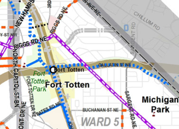
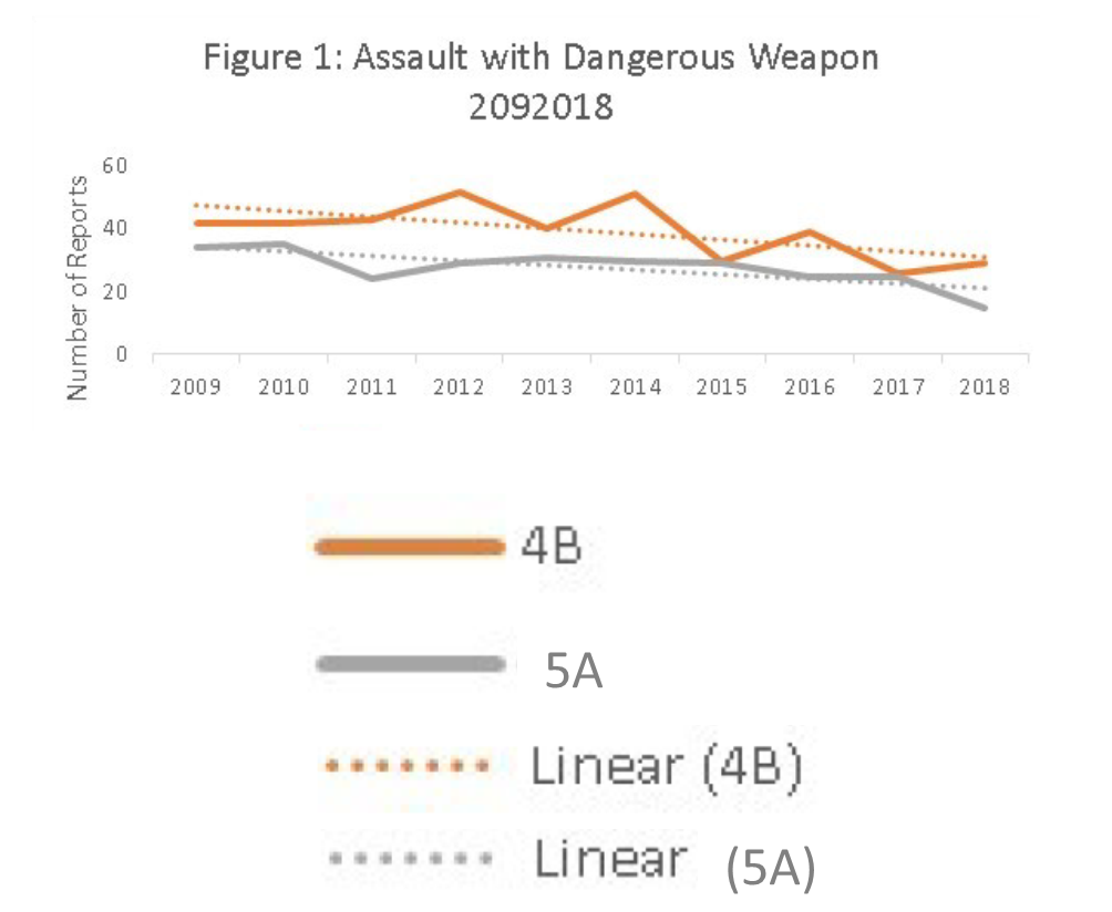
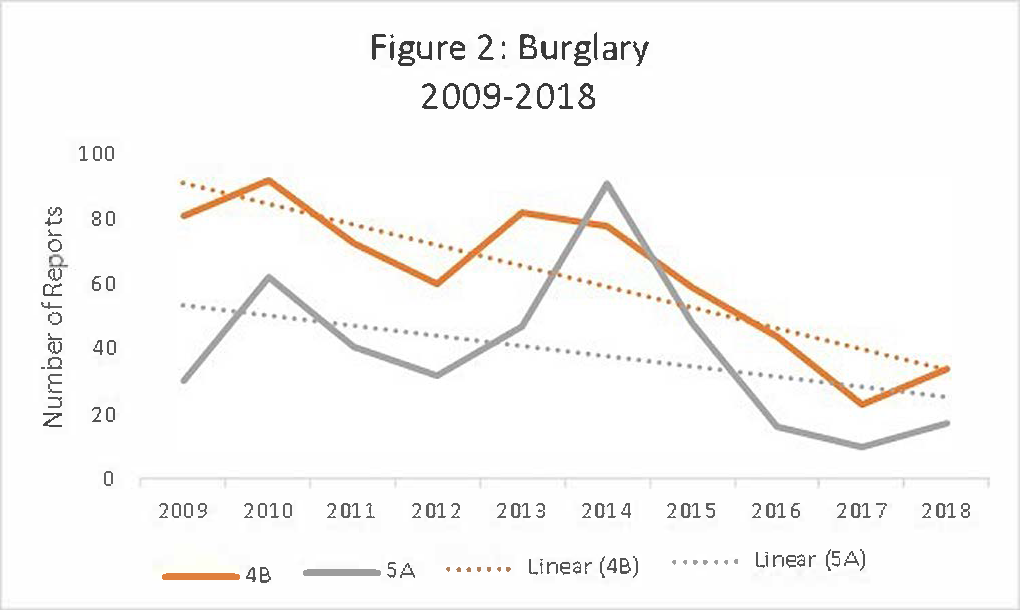
Below are some of the findings. The complete data and my analyses are available here (excel spreadsheet). Please note that for each graph, the “X” axis represents the calendar year, while the “Y” axis is the aggregate number of reports made. Solid orange and gray lines represent ANC 4B and ANC 5A, respectively. Dashed orange and gray lines represent trendlines for the two ANC areas as well.
Figure 1
Assaults with a dangerous weapon (ADW) are defined as aggravated assaults that knowingly or purposely cause serious bodily injury, threaten to do so, or knowingly engage in conduct that creates a grave risk of serious bodily injury to another person. In ANC 4B and 5A, these offenses apear to be trending downward over the decade (Figure 1, above). Since 2009, ANC 4B and 5A experienced a 31 percent and 55 percent decline, respectively, in reports of this crime.
Figure 2
Figure 2 shows that burglaries in the neighborhood are also trending downwards. Burglary is the unlawful entry of a structure, vessel, watercraft, railroad car or yard where chattels are deposited with the intent to commit any criminal offense. ANC 4B and 5A experienced a 58 percent and 43 percent decline, respectively, in this reported crime between 2009 and 2018.
Figure 3
Building on the downward trends, motor vehicle thefts, which are defined as the theft of any self-propelled, motor driven vehicle that is primarily intended to transport persons and property on a highway, also show declines over the decade. From Figure 3, we can see a 36 percent and 48 percent decline in the report of this offense in ANC 4B and 5A since 2009.
Figure 4
Robberies are defined as taking of anything of value from another person by force, violence, or fear. The downward trend in offenses goes for robbery too in our neighborhood. When looking at 2009 to 2018, a 64 percent and 41 percent decline were observed in ANC 4B and 5A, respectively, for reports of robbery (Figure 4). Not everything is going down though. As MPD officers regularly remind us at community meetings, thefts are a major problem. Generally speaking, theft is defined as wwrongfully obtaining or using the property of another with the intent to deprive the owner of the value thereof.
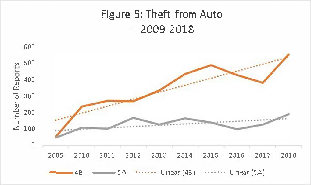
Figure 5
Not everything is going down though. As MPD officers regularly remind us at community meetings, thefts are a major problem. Generally speaking, theft is defined as wwrongfully obtaining or using the property of another with the intent to deprive the owner of the value thereof.
Let’s focus our attention first on theft from automobiles. This is specific foritems from within a vehicle, excluding motor vehicle parts and accessories. As Figure 5 shows, this offense has steadily risen in our neighborhood ANCs over the decade. ANC 4B and 5A experienced 10x and 2x increase in reports of thefts from autos when comparing 2009 to 2018.
Figure 6
Further, reports of other thefts (e.g., embezzlement, theft of services, fraud, and false pretenses) are a mixed bag. This category of offenses held relatively steady, according to the trendlines (Figure 6), over the decade in ANC 4B, while 5A did experience a modest decline.
Reports of
homicide, sex assault, and arson were best displayed as absolute numbers rather
than in graphical form (Table 1). For reference, MPD defines homicide as the killing of another purposely, or otherwise, with malice
aforethought. Sex abuse is engaging in or causing another person to submit to a
sexual act, by force, threat, fear, involuntary impairment, or rendering
unconscious, where consent was not willingly given. Arson is the malicious
burning, or attempt to burn, any structure, vessel, vehicle, railroad car or
property of another.
Table 1
Homicide`
Sex Abuse
Arson
Year
4B
5A
4B
5A
4B
5A
2009
0
2
3
4
0
0
2010
3
2
1
1
0
0
2011
4
0
1
2
1
0
2012
0
5
7
5
0
0
2013
3
0
7
3
1
0
2014
0
1
4
8
0
0
2015
2
1
8
7
0
0
2016
3
0
7
7
0
0
2017
2
2
8
3
0
0
2018
3
0
3
6
0
1
Total
20
13
49
46
2
1
Reports of
homicide, sex assault, and arson were best displayed as absolute numbers rather
than in graphical form (Table 1). For reference, MPD defines homicide as the killing of another purposely, or otherwise, with malice
aforethought. Sex abuse is engaging in or causing another person to submit to a
sexual act, by force, threat, fear, involuntary impairment, or rendering
unconscious, where consent was not willingly given. Arson is the malicious
burning, or attempt to burn, any structure, vessel, vehicle, railroad car or
property of another.
Community members often express concern that the majority of crime in Riggs Park likely occurs within close proximity to the Riggs-LaSalle Recreation Center. So, I pulled those data too, and you can decide for yourself.
Table 2 below depicts the aggregate counts of offenses reported over the decade within a 1,500-ft radius of this ANC 4B facility. For those interested, additional data are available on the Lamond Recreation Center in the supporting materials linked above.
Table 2
Year
ADW
Burglary
Homicide
Vehicle Theft
Robbery
Sex Abuse
Theft from Auto
Theft Other
2009
11
5
0
14
15
0
4
24
2010
6
4
0
20
7
1
22
14
2011
5
8
1
22
3
0
27
10
2012
4
3
0
14
7
1
20
17
2013
4
6
0
12
9
2
21
17
2014
5
5
0
10
14
0
36
39
2015
14
6
0
10
11
3
39
45
2016
12
4
2
7
5
1
63
89
2017
8
4
0
5
18
0
53
82
2018
5
3
1
9
3
1
89
85
Total
74
48
4
123
92
9
374
422
In summary, reports
of offenses such as assaults with a dangerous weapon, burglary, motor vehicle
theft, and robbery are trending downwards in our community, while reports of
thefts from automobiles have risen over the decade.
Though each offense is one too many, especially if you are a victim of the crime, the overall trend is promising for the Riggs Park area. The data show we’re moving in the right direction for the most part. We must build on this together by continuing to encourage public safety generally, getting to know our MPD officers, and by maintaining vigilance in our daily lives. Further, we must heed the advice from MPD officers and not keep any items of value visible in our vehicles. We must not stay silent, but rather speak out when illegal behavior happens, like in this Next Stop . . . Riggs Park post. As we are reminded in community meetings, it is up to us, as community members, to report crimes when they occur. And yes, you actually can be anonymous when calling 911 and when texting tips to the police at 50411. By doing this, and remaining civil with each other in the process, we will achieve a community where everybody can feel safe and welcome in their neighborhood.
Riggs Park is just outside the study area, but Lamond is included. The study area is defined by Rock Creek and the Maryland border to the West, Eastern Avenue to the North, New Hampshire Avenue NE and the Red Line Metrorail tracks to the East, and Military Road NW, Missouri Avenue NW, and Riggs Road NE to the South.
The District Department of Transportation (DDOT) will host its first public event for the Rock Creek East I Livability Study on Wednesday, February 6, 2019, from 6:30 pm to 8:30 pm. The purpose of this neighborhood study is to identify opportunities to enhance community quality of life through transportation safety and access improvements for all modes within the study area. At the first public event, DDOT will introduce the project, share data collection, and provide opportunities for participants to share existing concerns.
When: Wednesday, February 6, 2019, 6:30pm – 8:30pm
Where: Juanita E. Thornton/Shepherd Park Neighborhood Library
7420 Georgia Ave. NW (SPK Meeting Room 2)
Washington, DC 20012
Project Background
DDOT is undertaking the Rock Creek East I Livability Study to evaluate the transportation network in the study area from a system perspective, and look for opportunities for a safer and more accessible multimodal network. This study will be led with a data-driven approach, using existing and future conditions to understand transportation challenges and opportunities and to recommend specific implementable actions. The study will be supported with robust public outreach throughout the process. You can find out more about the study by visiting www.rceast1.com.
Questions?
Contact the DDOT Project Manager: Cynthia Lin, cynthia.lin@dc.gov, (202) 671-2381
MORRIS AND GWENDOLYN CAFRITZ FOUNDATION PARTNER WITH ALDI IN FORT TROTTEN
Art Place Mixed-Use Development In Northeast Washington, D.C. Opening 2022
WASHINGTON – February 4, 2019 – The Morris and Gwendolyn Cafritz Foundation (Cafritz Foundation), developers of the Fort Totten mixed-use development project Art Place, today announced that the lease has been executed for an approximately 25,000 square-foot ALDI store at Art Place at Fort Totten. Located on the corner of South Dakota Avenue and Kennedy Street, this will be the largest ALDI DC location and the second ALDI in the city, the first being in the H Street Corridor.
ALDI is a leader in the grocery retailing industry and operates more than 1,800 stores in 35 states. More than 40 million customers each month benefit from the simple, streamlined approach ALDI brings to retailing. ALDI sells frequently purchased grocery and household items, primarily under its exclusive brands, which meet or exceed national name brands on taste and quality.
“We are excited to announce this new addition to the Fort Totten area as part of Art Place,” said Jane Cafritz of the Morris and Gwendolyn Cafritz Foundation. “ALDI is known for providing customers with quality and value while ensuring a shopping experience that works with people’s busy lives. We welcome this transformative retailer to the area as we continue to enhance Fort Totten with innovative and art-focused partners.”
The new ALDI store is part of the second phase of the Art Place at Fort Totten development. The first phase opened in the fall of 2017 and includes, The Modern at Art Place, a 520-unit apartment building, Ramdass Pharmacy, Shiningstars Pediatric Dentistry and DMV Urgent Care.
The announcement of ALDI joining the development comes on the heels of the Cafritz Foundation’s announcement that Meow Wolf, the nationally renowned, immersive art experience will also be opening a 75,000-square-foot exhibition in the second phase of the development in 2022.
“In partnership with The Morris and Gwendolyn Cafritz Foundation, the Fort Totten ALDI store is one of our most innovative and cutting-edge real estate ventures to date,” said Jake DiPiazza, ALDI Frederick Director of Real Estate. “We’re eager to expand our presence in the Washington D.C. metropolitan area, and the Fort Totten store will be our second mixed-use development in the area, conveniently located for urban shoppers. The future is bright for our ALDI Washington, D.C. expansion.”
At full build out, the multi-phase development is anticipated to include nearly 2 million square feet across a mix of uses. These uses include multi-family residential, retail, cultural, art, public and entertainment spaces.
Media Contact:
Sofia Royce, PR Director
The Brand Guild sofia@thebrandguild.com
202.733.5223
About The Morris and Gwendolyn Cafritz Foundation
The Morris and Gwendolyn Cafritz Foundation is the largest private, independent, local foundation dedicated exclusively to the Washington, D.C. metropolitan area. The Foundation is the legacy of Morris Cafritz–one of Washington’s leading commercial and residential builders from the early 1920’s to the mid-60’s–and is committed to improve the quality of life for residents of the area. Since 1970, the foundation has granted awards totaling more than $447 million. In just the last ten years, $185 million has been awarded to more than 961 organizations in Community Services, Arts & Humanities, Education, Health and the Environment.
Washington Business Journal is out with the news that Aldi will be coming to Riggs Park in the second phase of Art Place at Fort Totten with an anticipated opening date in 2022.
Lamond-Riggs Citizens Association Public Meeting February 4, 2019 7:00 pm-8:30 pm Location: LaSalle-Backus Education Campus (501 Riggs Road NE, enter auditorium on Madison Street)
Agenda:
* DC Fire & EMS – Update on Right Care, Right Now ambulance transport policy
* DDOT – Pedestrian Safety Issues on South Dakota Avenue/Riggs Road NE corridor
ANC 5A held its monthly public meeting on January 30, 2019. Five commissioners were present for a quorum: Frank Wilds (5A01); Emily Lucio (5A03); Ronnie Edwards (5A05); Sandi Washington (5A07); Gordon Fletcher (5A08).
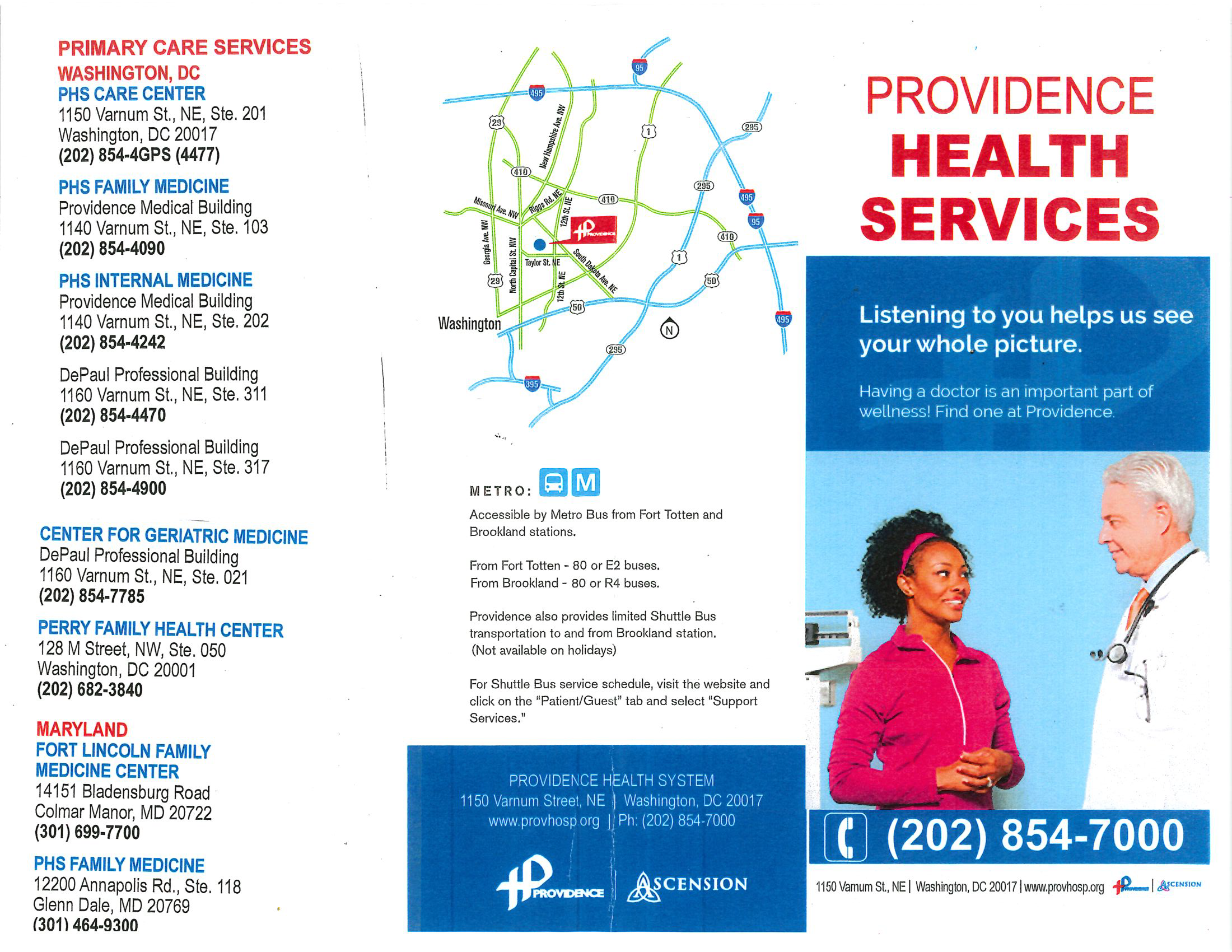
Providence took up most of the discussion time. The long and short of it is that Providence Hospital is ending its emergency and acute care services on April 30, 2019, as has been widely discussed. What has been less discussed is that Providence intends to continue providing primary and outpatient behavorial health care, as noted in this press release from December 2018, through an entity called Providence Health Services (PHS). Primary care services include internal medicine, family medicine, and geriatric services. A pediatric clinic and outpatient behavorial health services are provided on the campus by separate entities and will continue operating. Carroll Manor Nursing and Rehabilitation center will also remain in operation on the campus. PHS representatives explained that PHS is a group of practitioners providing primary care services under the license of Providence Hospital. PHS would like to continue providing primary care services once the hospital closes, but in order to do so it needs its own certificate of need (or license) from DC’s Department of Health (DOH). PHS stated they receive the majority of their patients from Wards 1, 5, 6, 7, and 8, so they are visiting the ANCs in those wards to show DOH that it has done outreach to those communities to explain that it is seeking a certificate of need to continue providing services.
Providence Hospital and Providence Health Services are both owned by Ascension (one resident noted Providence should have brought a flow chart to show the corporate structure). The PHS representatives repeatedly stated that Ascension is committed to continue providing primary services via PHS. Commissioners and residents alike questioned why anyone should trust what Ascension says given the lack of candor and communication around the closure of services at Providence Hospital. Residents noted that Providence’s messaging about what services are closed and which ones will remain open has been lacking and inconsistent throughout this transition process. PHS committed to communicating with Commissioner Lucio (5A03), who represents the area in which the hospital is located, to keep residents informed about the transition.
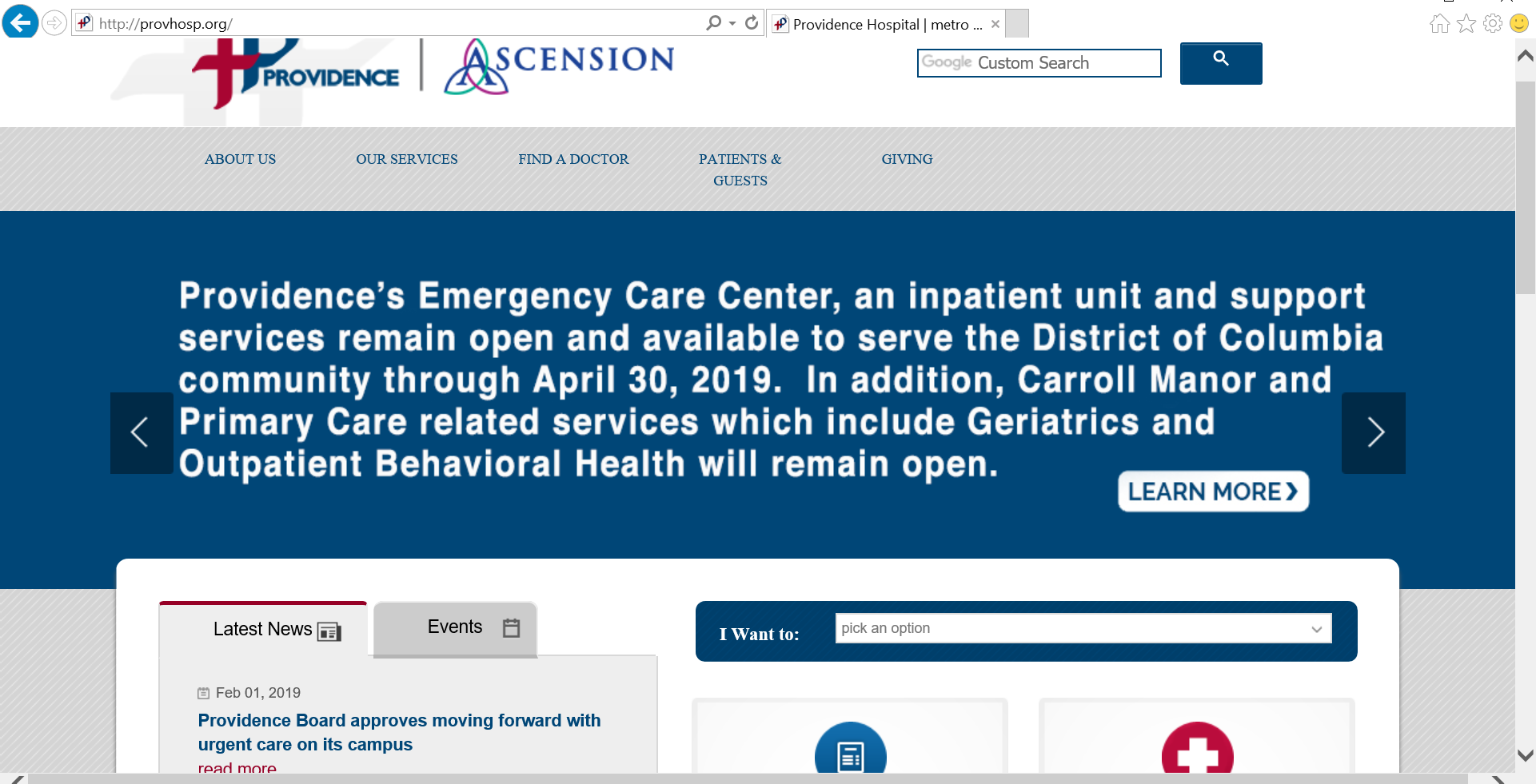
(Aside: The day after the ANC meeting, Providence issued a news release stating it is seeking a certificate of need to provide urgent care services on the campus. Then a new banner explaining that primary care services will continue to be provided was prominently featured on the website, though the link to the content in that banner appears to be broken.)
Providence website updated February 1, 2019
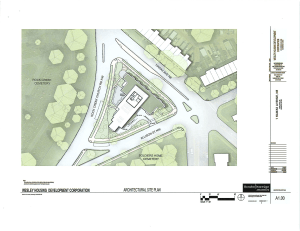
Wesley Housing
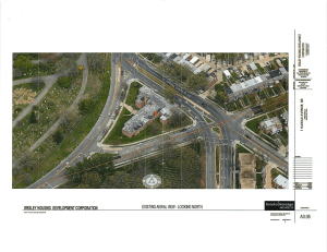
Aerial view of existing building
Aerial rendering of proposed new building
Wesley Housing was back before the ANC to receive approval for its curb cut application that is pending with the District Department of Tranportation’s public space committee. As explained previously, Wesley Housing wants to move the existing curb cut on Rock Creek Church Road NW to Allison Street NW. The issue is that they applied for the curb cut at the same time that they applied for approval to replace the entire apartment building with a new one with more units, a separate planned unit development (PUD) process that will need to be approved by DC’s Zoning Commission. This project is also contingent on receiving financing from the District Department of Housing and Community Development. The developer will present on the proposed development at a later date, but anticipates that with all of the required regulatory processes, construction will not start until 2021.
Wesley Housing explained last night that they filed the curb cut and PUD applications concurrently on the advice of DDOT and that they do not plan to put in the desired curb cut before the new development is constructed. The developer wants the curb cut on Allison Street for the new project because they plan to build a below-grade garage, having the cut on Allison will enable them to build out a terrace overlooking Rock Creek Church, they do not want to back up traffic on Rock Creek Church, and Allison is a one-way street so it will be easier for vehicles to maneuver turns into and out of the driveway.
When commissioners continued to express that it makes no sense for the commission to consider a curb cut application separate and apart from the proposed development itself, Wesley Housing’s representative stated that ANCs should prepare themselves to see other developers file these types of concurrent applications because developers seem to think this approach could reduce the amount of time it takes projects to get approved.
The ANC again tabled a vote on the curb cut application stating it does not make sense for them to be considering items piecemeal for a project on which they have not been briefed and that might not be approved. The ANC plans to reach out to DDOT to figure out why DDOT thinks this makes sense. The ANC will once again consider a special meeting, tentatively scheduled for February 20, to discuss and possibly vote on the curb cut issue. A hearing on the curb cut application is scheduled for February 28.
South Dakota Avenue Pedestrian Safety Improvements
Riggs Park resident David Kosub presented on pedestrian safety improvements at South Dakota Avenue and Ingraham Street NE, for which residents are requesting the ANC’s support in the form of a resolution.
Mr. Kosub highlighted the problems pedestrians face (with video footage, apologies from Mr. Kosub for the brief curse word), outlined the actions residents have taken to date to address the issues, and encouraged the ANC to support a resolution to enhance pedestrian safety. (Mr. Kosub previously wrote about these issues on this blog here, here, and here). The specific community concerns that the resolution seeks to address include:
Issue for public safety and well-being
Should not fear crossing the street
Vehicular traffic regularly fails to stop for pedestrians
Inadequate signage on South Dakota for pedestrian crossings
Unclear why the most appropriate path to the metro station (Ingraham) remains unsignalized
Anxious issue will go unaddressed and become worse due to inaction
The draft resolution requests that the District Department of Transportation:
Continue engaging with the Commission and residents to identify all hazardous locations for pedestrians along the South Dakota Ave corridor from Riggs Road to Galloway Street NE
Install a traffic signal at the intersection of Ingraham Street NE with South Dakota Ave NE (as originally discussed in the Planned Unit Development for the Art Place at Fort Totten project reviewed by the District Department of Transportation, Case #06-10)
Expedite remedies for the South Dakota Avenue NE intersections with Ingraham St NE and Jefferson St NE to improve pedestrian safety
In the absence of a signalized intersection at Ingraham Street NE and South Dakota Ave NE, install static signage (including Pedestrian Crossing, Yield, Radar announcements, etc.) for pedestrian crossings with red flashing lights
Improve lighting on the entire South Dakota Avenue NE Corridor from Riggs Road NE to Galloway Street NE, particularly at intersections so that drivers can see and stop for pedestrians waiting to use crosswalks
Investigate the timing of signalization lights along the South Dakota Avenue NE corridor to identify a potential strategy to reduce speeding and red light running
(Disclosure: I had a hand in contributing to the resolution)
The resolution notes that these action items are consistent with the District’s Vision Zero goals as well as the neighborhood’s small area plan. Several residents spoke up in favor of the pressing need for ANC as well as Council support for getting these improvements done, as residents have been working to resolve these issues since November 2017.
Most of the commissioners acknowledged that crossing South Dakota Avenue is an issue and were generally supportive. Commissioner Wilds, who represents the area in which this is an issue, stated that having a traffic signal at Ingraham would delay motorists; he generally seemed confused about which streets lead directly to Fort Totten metro station; and he seemed to seriously dispute residents and commissioners alike that motorists speed down South Dakota Avenue. When it came time for the ANC to vote on the draft resolution, Commissioner Wilds abstained. When asked why he was abstaining, he stated that he had not been invited to the community brainstorming session held in December 2018. Mr. Kosub stated he invited Commissioner Wilds to that meeting in person and via email. The four other commissioners present–Commissioners Lucio (5A03), Edwards (5A05), Washington (5A07), and Fletcher (5A08)–all voted to support the sense of the draft resolution with the goal of finalizing a resolution for presentation to DDOT.
Miscellaneous
The commission agreed to work with a resident that requested the ANC to work with the Office of Advisory Neighborhood Commissions to correct the official record that discusses when the first commissioners were elected and who served when in the early years of the ANCs. The resident identified some errors in the record with respect to Ward 5 ANCs so he stated there are probably others and he believes it is important for the record to be accurate.
Representatives from Mundo Verde spoke briefly about the school and its continued desire to expand to a campus at 8th and Varnum NE. The school has presented several times before the commission.
Ward 5 Councilmember Kenyan McDuffie is holding a Ward 5 Budget Engagement Forum on February 13, 2019, at 6:30 pm at Luke C. Moore High School (1001 Monroe Street NE).
Councilmember McDuffie is working with the ANC to explore a liquor license moratorium for North Michigan Park. The ANC protested a liquor license for Pax Liquor, which is seeking to open a liquor store in North Michigan Park. A hearing on that liquor license application was held on January 16, 2019. Commissioner Edwards said he expects a decision within 60 days from the date of the hearing.
The ANC voted to seek bids for cameras for the ANC office that is located inside UDC-CC Backus. Commissioners believe someone is using supplies that belong to the ANC without authorization because the ANC’s copier broke and its supplies have been depleted.